Download presentation
Presentation is loading. Please wait.

1
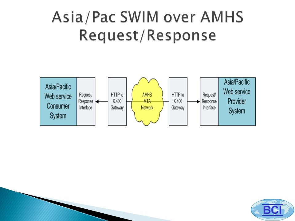
The Next Generation Network Enabled Weather (NNEW) SWIM Application Asia/Pacific AMHS/SWIM Workshop Chaing Mai, Thailand March 5-7, 2012 Tom McParland, BCI SP/8
 SWIM Application Asia/Pacific AMHS/SWIM Workshop Chaing Mai, Thailand March 5-7, 2012 Tom McParland, BCI SP/8")
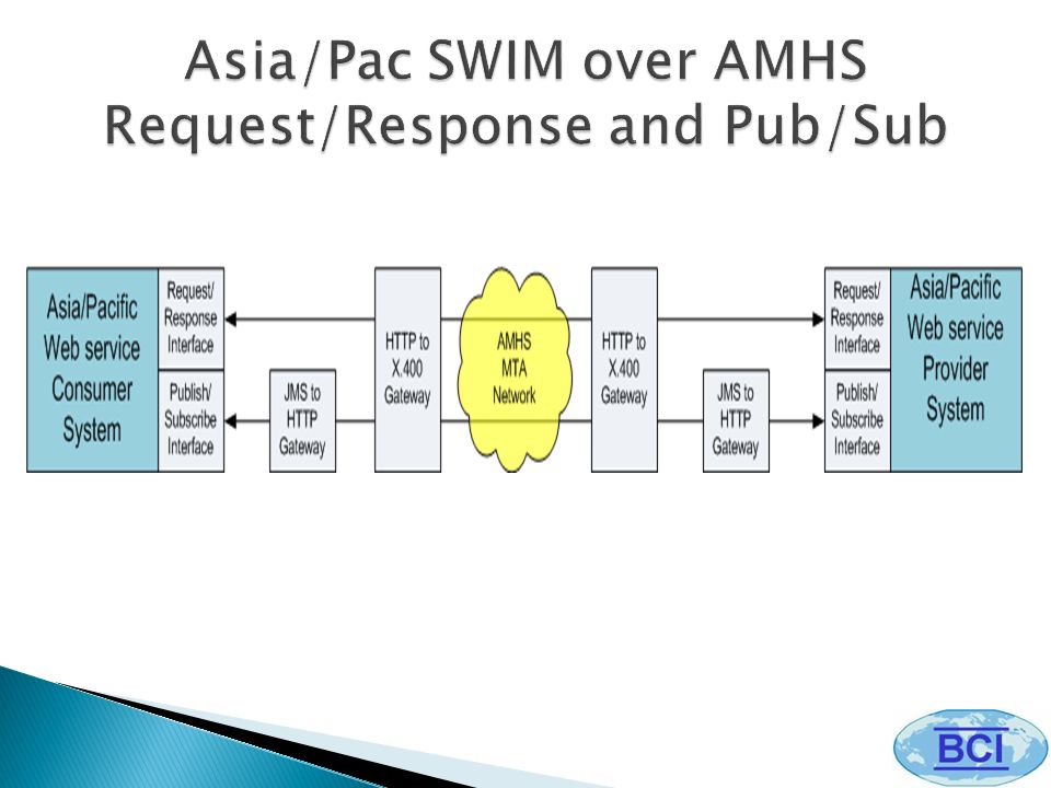
2
Geographic Information Systems (GIS) Vector Data, Raster Data OGC Data Access Standards WCS, WFS, WMS Services Relationship of Standards WCS, WFS, WMS Operations and Bindings NextGen Network Enabled Weather (NNEW) NNEW and the 4-D Weather Cube NNEW Interface Extensions OGC-defined Request/Response and NNEW-defined Pub/Sub Asia/Pacific SWIM over AMHS HTTP/X.400 Gateway JMS/HTTP Gateway
 Vector Data, Raster Data OGC Data Access Standards WCS, WFS, WMS Services Relationship of Standards WCS, WFS, WMS Operations and Bindings NextGen Network Enabled Weather (NNEW) NNEW and the 4-D Weather Cube NNEW Interface Extensions OGC-defined Request/Response and NNEW-defined Pub/Sub Asia/Pacific SWIM over AMHS HTTP/X.400 Gateway JMS/HTTP Gateway")
3
Historically, geographic information has been treated in terms of two fundamental types called vector data and raster data. Vector data deals with discrete phenomena, each of which is conceived of as a feature. The spatial characteristics of discrete real-world phenomenon are represented by a set of one or more geometric primitives (points, curves, surfaces or solids). Other characteristics of the phenomenon are recorded as feature attributes. Raster data deals with real-world phenomenon that vary continuously over space. It contains a set of values, each associated with one of the elements in a regular array of points or cells. Source: ISO 19123:2005
. Other characteristics of the phenomenon are recorded as feature attributes. Raster data deals with real-world phenomenon that vary continuously over space. It contains a set of values, each associated with one of the elements in a regular array of points or cells. Source: ISO 19123:2005.")
4
The Open Geospatial Consortium (OGC) has defined several Data Access services. Web Feature Service (WFS) provides features (vector data) as a Web service Web Coverage Service (WCS) provides coverages (raster data) as a Web service Web Map Service (WMS) provides rendered maps containing a base map with layered feature and coverage data as a Web service
 provides features (vector data) as a Web service Web Coverage Service (WCS) provides coverages (raster data) as a Web service Web Map Service (WMS) provides rendered maps containing a base map with layered feature and coverage data as a Web service.")
7
Web Feature Service (WFS) defines protocols for requesting GML Features through HTTP requests. GML Features are geospatial objects such as images or GML documents that describe real-world entities, e.g. meteorological objects (fronts, precipitation areas), weather observation readings, observation stations or roads as a combination of the entities geometry (points, lines, or polygons) and attributes (other information about those entities).
, weather observation readings, observation stations or roads as a combination of the entities geometry (points, lines, or polygons) and attributes (other information about those entities)..")
8
The WFS specification defines three basic operations: GetCapabilities queries the WFS service to determine available options; DescribeFeatureType retrieves the XML schema to allow the WFS client to parse the result; and GetFeature performs the actual query.

10
The Web Coverage Service (WCS) is similar to WFS, but instead of images or features deals with coverages, i.e. digital geospatial information representing space-varying phenomena. WCS operates with gridded data, i.e. collections of mappings from geometry (grid points) into parameter (temperature, pressure, etc.) values. WCS provides access to intact (unrendered) geospatial information, as needed for client-side rendering, multi- valued coverages, and input into scientific models and other clients beyond simple viewers.
 into parameter (temperature, pressure, etc.) values. WCS provides access to intact (unrendered) geospatial information, as needed for client-side rendering, multi- valued coverages, and input into scientific models and other clients beyond simple viewers..")
11
Similar to WFS, the WCS client can request the WCS server for available options using the GetCapabilities operation; ask the server to describe coverages of interest with DescribeCoverage operation; and create and return the requested subset of the available coverage data with GetCoverage operation.

13
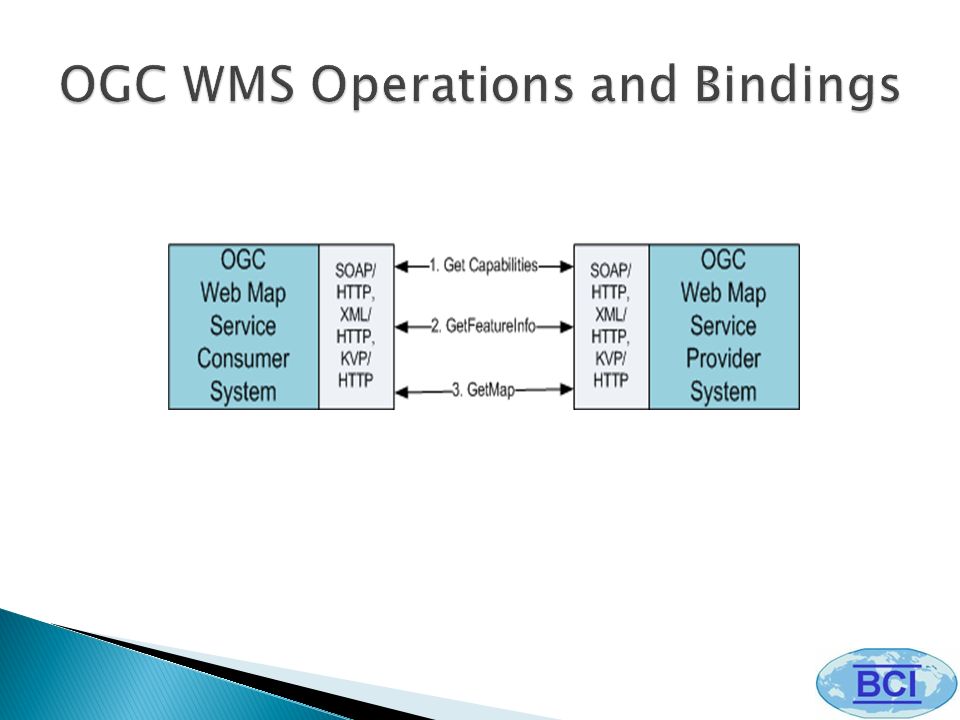
The OGC WMS produces maps of spatially referenced data dynamically from geographic information. This standard defines a "map" as a digital image file suitable for display on a computer screen (map is not the data itself). WMS-produced maps are generally rendered in a pictorial format such as PNG, GIF or JPEG.
. WMS-produced maps are generally rendered in a pictorial format such as PNG, GIF or JPEG..")
14
WMS defines three operations: GetCapabilities provides a description of the available information content and acceptable request parameters; GetMap returns a map as an image; GetFeatureInfo provides information about features at a point on a map.

16
Source: MIT LL

18
NNEW offers the OGC defined request/response services (i.e. WFS, WCS, and WMS Web service interfaces) NNEW has also defined interface extensions to the OGC standard WFS and WMS operations. The extensions enable a client to subscribe to a service and then receive the data or notifications about the data over a publish/subscribe interface.
 NNEW has also defined interface extensions to the OGC standard WFS and WMS operations. The extensions enable a client to subscribe to a service and then receive the data or notifications about the data over a publish/subscribe interface..")
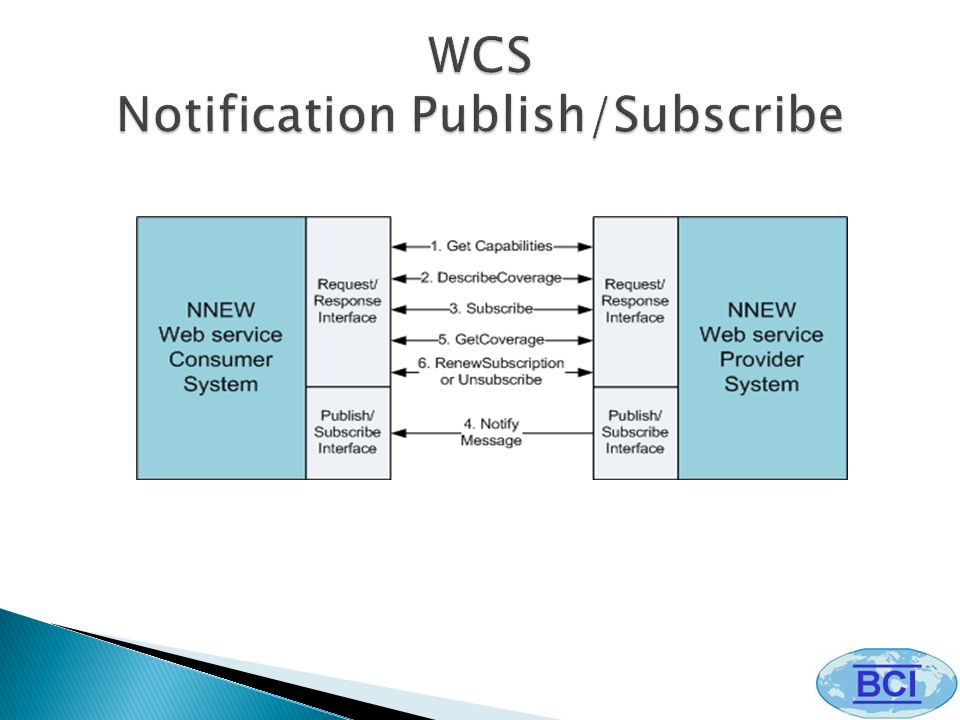
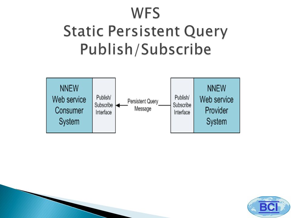
20
An NNEW Service Provider may be configured to support several different types of Exchange Scenarios (i.e., a particular combination of request/response and publish/subscribe service interfaces.) 1.WFS, WCS, WMS Request/Response (i.e. OGC Request/Response) 2.WFS Persistent Query Publish/Subscribe 3.WCS Notify Publish/Subscribe 4.WFS Static Persistent Query
 2.WFS Persistent Query Publish/Subscribe 3.WCS Notify Publish/Subscribe 4.WFS Static Persistent Query.")
Similar presentations


 Washington University, St. Louis, MO OGC TC.>")


 1 GIS Web Services NDFD Technical Workshop November 2, 2006 John Schattel ->")


