Download presentation
Presentation is loading. Please wait.

6
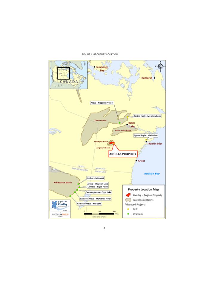
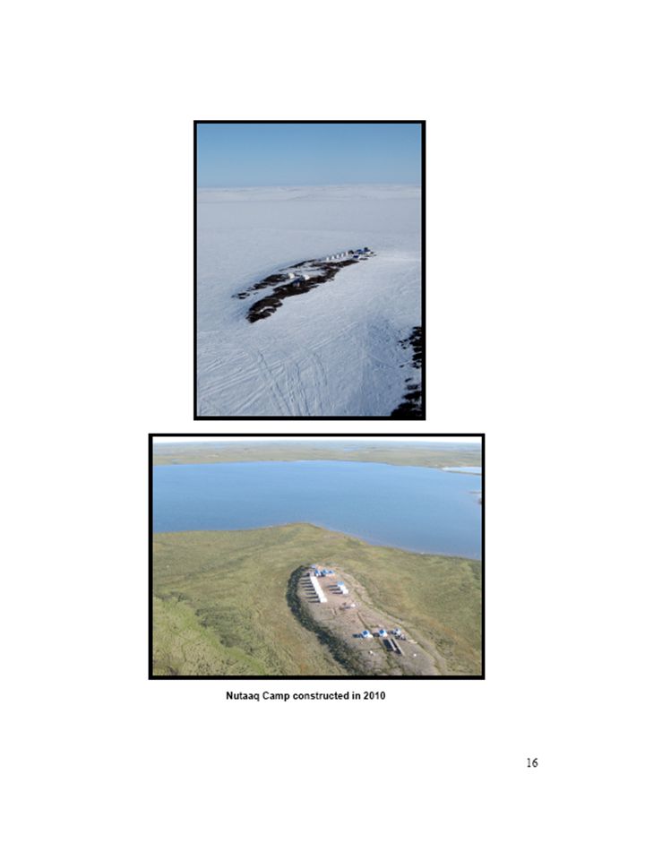
ANNUAL REPORT 2010 Inuit Land Use Licence Number: KVL308C09 INAC Land Use Permit Number: N2008C0026 Submitted to: KIA, INAC, NIRB Prepared by: Andrew Berry, Vice President of Operations Kivalliq Energy Corporation Submitted on: March 14, 2011 2 TABLE OF CONTENTS Section Page Property Description and Location 4 Corporate Background and Project Description 7 Work Completed To Date 2010 Program 9 Baseline Studies 19 Environmental Considerations 23 Mitigation Measures 27 Waste Management 28 Fuel Inventory 31 Flight Summary 31 Reclamation 33 Socio-Economic Benefits 33 Community Consultation 34 Archaeology and Traditional Knowledge 34 3 Section Page Tables Table 1: 2010 Land Use Permits and Licences 4 Table 2: Wildlife Sightings Summary 24 Table 3: Water Use Summary 26 Table 4: Incineration Summary 29 Table 5: Fuel Cache 30 Table 6: Helicopter Touchdown Summary 32 Figures Figure 1: Angilak Project Location 5 Figure 2: Angilak Project, Land Tenure 6 Figure 3: 2010 Drill Target Locations 13 Figure 4: General Camp Layout 15 Figure 5: Cat Train Route 17 Figure 6: Bio-Physical Baseline Studies 21 Figure 7: Wildlife Monitoring Study Area 22 Appendices 35 Appendix A: 2010 Cat Train Route Coordinates Appendix B: 2010 Water Use Appendix C: 2010 Helicopter Touchdowns Appendix D: 2010 Drill Hole Locations and Drill Site Photos Appendix E: 2010 Contractor Services Appendix F: 2010 Community Consultation Log 4 PROPERTY DESCRIPTION AND LOCATION The Angilak Project property consists of 90 active mineral claims and Inuit Owned Land Parcel RI-30 (IOL), comprising a total area of 90,930 hectares (224,686 acres) in the Kivalliq region of southern Nunavut Territory. The property is located 350 kilometres west of Rankin Inlet and 225 kilometres southsouthwest of Baker Lake (Figure 1), and currently measures 65 kilometres in an east-west direction and approximately 30 kilometres north-south. As indicated on Figure 2, all mineral claims and the IOL are contiguous and extend north, south, east and west between latitudes 62° 26’ and 62°43’ North and longitudes 98° 21’ and 99°24’ West in NTS map areas 65 J/06, 65 J/09, 65 J/10 and 65 J/11 (UTM coordinates: 6925000N to 6955000N and 480000E to 535000E, NAD83, Zone 14). Land use permits, enabling exploration work to be conducted over the entire property area, have been issued, renewed and amended by the Kivalliq Inuit Association (KIA) for parts of the property covering Inuit Owned Lands (IOL) and by Indian and Northern Affairs Canada (INAC) for Crown lands. Kivalliq Energy Corporation (Kivalliq Energy) also operates under the terms and conditions of a Nunavut Water Board (NWB) licence, covering activities on IOL and Crown Lands. 2010 was the third year that Kivalliq Energy operated on the lands described in this report and the second year with drill operations. See Table 1 for a list of active permits and licences issued for lands that comprise the Angilak Project. Table 1. 2010 / 2011 Land Use Permits and Licences Issuing/Screening Agency Date Issued File Number KIA August 1, 2008 KVL308C09 NIRB July 31, 2008 08EN052 INAC August 8, 2008 N2008C0026 NWB August 6, 2008 2BE-ANG0813 FIGURE 1: PROPERTY LOCATION 5 FIGURE 2: LAND TENURE 6 7 CORPORATE BACKGROUND AND GENERAL INFORMATION Following the establishment of a uranium policy by Nunavut Tunngavik Inc. (NTI) in September 2007, Kaminak Corporation (a predecessor to Kivalliq Energy Corporation,“Kivalliq”) signed an exploration agreement with NTI on May 8, 2008 that granted uranium rights to Kaminak on 18,000 acres of Inuit Owned Land (IOL RI-30), located in the Kivalliq District of Nunavut. In discussions with NTI, it was decided cooperatively that Kaminak spin-out all of its uranium interests in Nunavut into a new, uranium exploration and development company called Kivalliq Energy Corporation (KIV: TSX-V). Kivalliq Energy Corporation was specifically formed to focus on projects in Nunavut. Management has extensive background working in Canada’s north. John Robins is Chairman of the Company’s board of directors, Jim Paterson is the Chief Executive Office and Jeff Ward serves as President. Mr. Chris Twells is Chief Financial Officer and Mr. Andrew Berry is Vice President, Operations. Dr. Robert Carpenter, Jim Dawson and Garth Kirkham serve as directors. The group is committed to the social and economic development of the north while maintaining a level of excellence in minimizing environmental impacts. Kivalliq looks forward to conducting a third community tour this year to meet with community members and increase awareness about the company and its projects. Kivalliq was the first company in Canada to have a comprehensive agreement to explore on Inuit Owned Land for uranium. As part of this landmark partnership, NTI receives shares in Kivalliq and can elect to have a participating interest in the project, or collect royalties at a later date. Kivalliq also makes advance royalty payments to NTI annually and commits to specific work programs until 2012. The agreement not only applies to privately-held Inuit Owned Land, but also extends to 90 Crown issued claims. The Angilak property totals 225,000 acres in all. Since 1979, the property and surrounding area has been called various names (i.e. LGT, Yathkyed, Lac Cinquante); however going forward, Kivalliq collectively refers to all land holdings as the “Angilak Property”. The Angilak claims and IOL RI-30 are host to over 150 mineral showings and in particular the high-grade Lac Cinquante uranium deposit, On February 7, 2011 the Company received a summary report for Lac Cinquante that describes an Inferred Mineral Resource Estimate of 810,000 tonnes grading 0.79% U 3 O 8, totalling 14.15 million lbs U 3 O 8 (17.5 lbs U 3 O 8 /tonne) at a 0.2%U 3 O 8 cut-off grade. The Mineral Resource estimate was prepared under the direction of Robert Sim P.Geo., of SIM Geological Inc. A resource model was generated using drill sample assay results from Kivalliq’s 2009 and 2010 field seasons (up to October 31, 2010), and interpretation of a geological model relating to spatial distribution of uranium. For evaluation purposes, three additional metals: silver (g/t), molybdenum (%) and copper (%) were also estimated within the resource 8 model. Lac Cinquante is considered to be an early stage project, therefore little is known about its potential mining or metallurgical characteristics. However, the resource is considered to exhibit reasonable prospects for economic extraction, and the base case cut-off threshold of 0.2% U 3 O 8 is considered appropriate based on its location and other assumptions derived from deposits of similar type and scale. This first 43-101 compliant mineral resource estimate for the Lac Cinquante uranium deposit represents a major milestone and provides the Company with a strong base from which to build additional uranium resources in 2011. 9 WORK COMPLETED TO DATE 2010 Program Exploration work in 2010 included the establishment of the Nutaaq Camp, diamond drilling, prospecting, environmental baseline studies and re-logging/resampling selected core from the historic core storage. Drilling Kivalliq Energy Corporation contracted Major Drilling Group International Inc. to perform diamond drilling on the Angilak Property in 2010. Under this contract Kivalliq completed 16,606 metres of diamond drilling in 107 holes from April 24 to October 16, 2010. Of these four drill holes tested exploration targets and three holes were lost due to poor drilling conditions. The work was undertaken using two Boyles diamond drill rigs. The first, a Boyles 37 fly rig, was staged on the property from drilling undertaken by Major Drilling in 2009. The second, a Boyles 17 fly rig, was mobilized to the property in late July and commenced operations at the beginning of August. A total of 100 drill holes (Figure 3) evaluated the Lac Cinquante uranium deposit in 2010. Each of these intersected the stratigraphic graphitic/sulphidic tuff quartz/carbonate vein unit that hosts the mineralized zone referred to as the Lac Cinquante main zone. Anomalous radiation associated with the main zone unit was intersected in 86 of these drill holes. The remaining 14 drill holes were barren of radiation within the main zone stratigraphy. Intersected grades ranged to a maximum of 6.86% U3O8 over a core length of 1.13 metres in DDH 10-LC- 089. The widest mineralized intersection was 13.98 metres grading 0.70% U3O8 in DDH 10-LC-003. Holes were drilled on a 50 metre grid oriented at 26 degrees and targeted to intersect the Lac Cinquante main zone at vertical intervals of approximately 50 metres. Hole inclination angles ranged from -45 degrees to -90 degrees. Down hole termination depths ranged from 47 metres to 302 metres. The Lac Drill rig at 10-NE-001 10 Cinquante zone was drilled along a strike length of 1350 metres. As a general rule drill holes were terminated approximately 10 metres after intercepting main zone mineralization. Using Portland cement all main zone intercepts running in excess of 0.05% U3O8 were cemented for a distance of at least 10m above and below the radioactive intercept. All drill holes were cemented for a distance of 35 metres from the overburden / bedrock interface. Major Drilling Group designed and installed a drill cuttings containment / collection circuit for Kivalliq Energy. The system utilized a sump pump and a series of four 150 gallon, inline settling tanks. To capture cuttings a small sump area was dug beneath the rig adjacent to the cuttings discharge from the drill casing. It was lined with an impervious liner. A sump pump placed within the sump removed all drill effluents from beneath the rig. The cuttings were pumped into tank one, the first of the four in-line tanks. Overflow from tank one is collected in tank two, from tank two to tank three and from tank three to tank four. A majority of the drill cuttings precipitate were contained in tank one. Incrementally lesser volumes of cuttings precipitated in tanks two and three respectively. Discharge from tank four was essentially clear water. From tank four, clear water can be circulated back through the rig or discharged. All four tanks had a 3” value at their base. Nonradioactive cuttings were released as a slurry from the bottom of each tank through a flexible 3” hose into 1 tonne fibrene bulk bags suspended at ground level from a jig. Excess water was allowed to weep through the weave of the bag material. After approximately 24 hours the dewatered bulk bags with cuttings were flown to a naturally occurring depression/sump where they were deposited. Major Drilling’s Boyles 36 Diamond drill rig and drill cuttings containment circuit. 11 Four (4) inline settling tanks are used to capture and contain all drill cuttings from the drilling process. Drill cuttings from the settling tanks are collected in 1 tonne bulk bags. Kivalliq isolates and collects radioactive cuttings using the cuttings collection circuit described above. The spatial occurrence of radioactive mineralization associated with the Lac Cinquante uranium deposit is predictable. Drilling has indicated that the Lac Cinquante main zone tuff strikes and dips coherently from hole to hole and between drill hole cross sections. Kivalliq geologists notify drill crews of the predicted intercept depth for the Lac Cinquante main zone lithologies when drill holes are spotted and collared. Drilling is temporarily suspended approximately 15 metres above the predicted intercept depth. The cuttings containment circuit is cleaned and all non- radioactive cuttings are 12 removed and collected in bulk bags. Drilling then proceeds to core through the target main zone mineralization. As a rule drill holes are terminated approximately 10 metres below mineralized Lac Cinquante main zone intercepts. Cuttings are provided a settling period while the drill hole is being surveyed and cemented and rods and casing are removed. Clear water is discharged. Radioactive cuttings are collected in 205 litre steel drums and sealed. The sealed drums are temporarily staged on a flat dry outcropping ridge on the east side of the Lac Cinquante drill area at 519615E 6939955N Nad 83 z14. Radioactive cuttings contained in seales 205 litre steel drums. Temporarily staged on an outcrop. Drums are flown to the temporary staging area with a vertical drum lifter. Prospecting During the 2010 summer field season, Kivalliq contracted prospectors from Taiga Consultants Ltd. from Calgary, Alberta and Discovery Consultants from Vernon, British Columbia. to undertake a prospecting program targeting historical uranium showings on the Angilak Property. The helicopter‐supported program consisted of four persons and was operational from early July to mid August. A three‐week follow‐up program was conducted during September 2010 with a two man crew. Prospecting crews examined more than 38 mineral showings during the course of the 2010 field season. These have been grouped and narrowed to 9 distinct areas that are considered to hold significant potential for subsurface uranium mineralization. A total of 291 rock samples were collected from outcropping bedrock and boulder exposures during the course of the program. Samples were shipped to SRC in Saskatoon for geochemical analysis. FIGURE 3: 2010 DRILL TARGET LOCATIONS 13 14 2010 Infrastructure An amendment for the establishment of a new camp on the Angilak property to facilitate easier logistical support and closer access to the Lac Cinquante work area was approved by INAC and NIRB in May 2009 and by NWB in January 2010. The new camp, constructed in 2010, is located at 527975m E, 6937950mN Nad 83 Z14, see Figure 4 for the general layout of the camp. The general area offers several flat topped gravel deposits formed in association with a large trunk esker trending south approximately 2 kilometres west of the proposed site. The location itself was selected due to several favourable natural attributes amenable to the efficient operation of an aircraft supported exploration facility. The site sits close to water on a dry, flat topped gravel deposit that lies elevated above the surrounding tundra. An adjacent flat topped feature situated immediately north trends several hundred metres and will accommodate ancillary facilities, specifically helicopter landing sites, core racks and fuel storage. A larger flat topped gravel deposit approximately 1.5 kilometres west of the camp site and proximal to the trunk esker serves as an airstrip for light aircraft. The entire camp area is situated directly north of a 1.5 kilometre x 4.1 kilometre long east–west trending lake which can easily accommodate both ski equipped and float equipped aircraft. The lake is currently used as the camp water source. In the future, should the project warrant, the lake is sufficiently long to allow the establishment of an ice strip to accommodate large aircraft. Aircraft commenced shuttling camp equipment and materials to the location of the new camp site on March 21, 2010. A four-man camp construction crew contracted from Discovery Mining Services out of Yellowknife NT was mobilized to site on April 4 and began building the camp infrastructure. By the time crews arrived on site commence drilling operations on April 21 the camp comprised twelve individual structures; 1-16’x32’ kitchen, 1-16’x32’ wash tent, 1- 14’x16’ toilet shack, 1-14’x16’ Level II First Aid facility, a 10’x12’ generator shed, 1- 14’X16’ office, 2-14’x16’ core and 4-14’x16’ vinyl Weatherport sleepers. Three additional Weatherport sleepers and a 14’X16’ kitchen overflow were added to the camp in June to support an increase in staff for the summer program. The camp remained open from April through to October. Exploration activities ceased on October 18 and all work crews vacated the camp. A three man crew from Discovery Mining Services was brought to site to winterize the camp and close it for the season. All canvas tent covers were removed from wooden tent frames. All Weatherport vinyl tents were left standing. The camp was shut down on October 27, 2010. Cat Train The exploration program was primarily supported by aircraft in 2010. During the month of April, as snow conditions allowed, a cat train comprising of two snow cats and eight sleds was utilised to transport bulk cargo from Baker Lake. The route coordinates that the Cat train followed can be found in Appendix A. This is also illustrated in Figure 5. FIGURE 4: 2010 NUTAAQ CAMP LAYOUT 15 16 Nutaaq Camp constructed in 2010 FIGURE 5: CAT TRAIN ROUTE 17 18 Cat Train used to haul supplies overland from Baker Lake to Nutaaq Camp. 19 Baseline Studies 2010 In 2010 Kivalliq Energy contracted Hemmera Envirochem Inc. to design and implement baseline studies that corresponded with the stage of current exploration. The studies in 2010 included: Hydrology, Water Quality, Air Quality, and Non-invasive, Observational Wildlife Monitoring. Hydrology The 2010 hydrological work consisted of a desktop study and the establishment of field sites. The goal was to characterize the hydrologic regime of the project area. Watersheds were characterized using digital elevation model (DEM) imagery within the study area. Eight sites were identified for manual measurements (Figure 6). Instantaneous water level and period peak water level were recorded every two weeks from the end of June until the seasonal camp closure in October. This information will for a base for future hydrology studies as the project advances. Water Quality The 2010 water quality program focuses on assessing and quantifying existing water quality conditions across the study area. Twenty sites were sampled (Figure 6) once in August. Water was analyzed for hardness, metals, pH, total suspended solids, ammonia, nitrate, cyanide and alkalinity. Temperature, pH and conductivity were also measured at each of the twenty (20) sites in August and September using a handheld meter. Meteorology On-site meteorological data was collected by a fully automated Onset Hobo Weather Station and an OTT Pluvio Rain Gauge. The weather station was installed in June 2010 (Figure 6). Parameters recorded include; air temperature, relative humidity, total precipitation, barometric pressure, wind speed and direction. Data has been collected since July 2, 2010. While camp was operational, manual weather information was also collected to ensure the weather station was functioning properly. Air Quality In the latter part of June 2010, four dust fall stations were established (Figure 6). Dust fall canisters were replaced every thirty (30) days, sealed and sent to the lab for analyses. A total of three rounds of samples were collected. Wildlife The goal of the 2010 wildlife program was to establish an overview of the wildlife species present, and general use of the area. The study area was defined as five (5) kilometre buffer around existing and proposed activity areas. The total 20 area encompassed approximately 169 km2 (Figure 7). Data was collected during two site visits by Hemmera personnel; June 27 to July 3, and August 16 to 21. During the initial visit, Kivalliq Energy staff were trained in documenting wildlife observations. Wildlife data was collected during non-invasive focal behavioural observations and incidental observations. #7 p XW # & G WQ9 WQ8 WQ7 WQ6 WQ5 WQ4 WQ3 WQ2 WQ1 WQ20 WQ18 WQ19 WQ17 WQ16 WQ15 WQ14 WQ13 WQ12 WQ11 WQ10 W4 W3 W2 W1 S1 N2 N1 C1 DF4 DF3 DF2 DF1 510000.000000 515000.000000 520000.000000 525000.000000 530000.000000 535000.000000 540000.000000 6930000.000000 6935000.000000 6940000.000000 6945000.000000 ± 0 1 2 3 0.5 Kms 1:45,000 March 2011 Early Stage Bio-Physical Baseline Studies Angilak Project Kivalliq Region, Nunavut 1190-001.01 N u n a v u t Site Location Legend G Dust Fall Station & Climate Station # Water level station XW Water Quality Station Study Area p Airstrip #7 Nutaaq Camp Approx Drilling Area Watershed Wetland Lake Streams Height Values 254 0 Yathkyed Lake Nutaaq Lake Kazan River Calpine Lake Big Gash Lake No Gash Lake Siuraq Creek Little Gash Lake Molson Lake Lac Cinquante Figure 6 ! #7 p kj ") !( ! !( &: HOL-C HOL-W HOL-ML1 HOL-ML2 510000.000000 515000.000000 520000.000000 525000.000000 530000.000000 535000.000000 540000.000000 6930000.000000 6935000.000000 6940000.000000 6945000.000000 ± 0 1 2 3 4 5 0.5 Kms 1:45,000 March 2011 Angilak 2010 Wildlife Program Study Areas, HOL Survey Locations & Carnivore Dens Angilak Project Kivalliq Region, Nunavut 1190-001.01 N u n a v u t Site Location Nutaaq Lake Kazan R iver Calpine Lake Big Gash Lake No Gash Lake Siuraq Creek Little Gash Lake Molson Lake Lac Cinquante Legend ! Height of Land - Camp !( Height of Land - Molson Lake 1 !( Height of Land - Molson Lake 2 !( Height of Land - Weather &: Grizzly Bear - Spring resting area ") Fox Den kj Inactive Wolf den p Airstrip #7 Nutaaq Camp Approx Drilling Area Wetland Lake Watershed Streams Study Area ! ! Potential Carnivore Denning Habitat Height Values 254 0 Yathkyed Lake Figure 7 Observed Caribou Migration Direction 23 ENVIRONMENTAL CONSIDERATIONS All employees and contractors working for Kivalliq Energy Corp. are made aware of the company’s internal policies and procedures and are made familiar with the Terms and Conditions of the project’s licences and permits. Every person arriving at the Angilak Project undergoes an orientation which includes information on health, safety and environmental responsibilities and stewardship. The orientation and training includes, but is not be limited to: spill response, bear safety, environmental policies (including waste management), wildlife mitigation measures and the caribou protection measures. Employees, contractors and visitors are asked to review printed materials from the orientation and to sign-off that they have received the orientation, reviewed the information materials and that they understand their individual responsibilities. Wildlife sightings are recorded in the field and at camp. See Table 2 for a summary of these sightings. Sightings are compiled for reporting in each annual report. All employees and contractors are required to populate the wildlife sightings sheets. Wildlife incidents will be reported immediately to the KIA and to the GN Wildlife Biologists. Contact information for emergency situations are hung on the wall of the office and provided on page 5 of the Wildlife Management and Mitigation Plan. Water and aquatic life will be protected. Waterlines for drilling and domestic use are properly placed to minimize disturbance to the shoreline and substrate and will be screened in accordance with the “Freshwater Intake End-of-Pipe Screen Guideline” prepared by the Department of Fisheries and Oceans. A copy of this guideline document is kept at the head office in Vancouver and at the field office at the project. No wastes enter any water bodies. This includes discharge from the camp and seepage from the drill and grey water sumps. The grey water sump will be inspected daily. Drill sumps will be inspected prior to the drill being moved and the area being reclaimed. Daily inspections will be conducted around the camp and a record of these inspections is kept in the office for review by the Inspector upon request while at the camp. Water use was recorded for both the domestic camp water and the water used at the drill. A summary of the water use by month is shown in Table 3. The complete water use data can be found in Appendix B. 24 Table 2. Wildlfe Sightings Summary !"#$#"%& !"#$!%!&!'()$!% !'()$!*!&!'()$!+% !'()$!+%!&!'()$!,- !'()$!,-!&!.(/!+ !.(/!0!&!.(/!,1 !.(/!0-!&!234!0 !234!%!&!234!5 !234!1!&!234!+, !234!+0!&!234!+% !234+%!&!234!+* !234!+6!&!234+1 !234!,-!&!234!,, 234&,0 234&,% !234!,*!&!234!0- !789!+!&!789!0 !789!%!&!789!5 !789!1!&!789+0 '(')# *+,*#)'&- :#; ( 0*,% %-- 0 ** % +, 0 % + +- 6 +6,- + 6./01 "(?@>A3B,, + + + +, 2/ '345678 90:1./: 2. 00. 2 :. /. 2 2/ 1 21 :2 9 1./11 ;)<+"=(<&- C>A!!?4D + +6, % +, +,, +, + + % +./ E;<FF)$!G3#; + + + + *, 22 E;3$!H>)I + +, + 0 + > H>)J3;<B3! 0 +, 1 K>9#)?L :2 / 9 1 2 9 2 / : 9 2 9 : 9 : 9 > 9 11 <($&+'- M3NN<B/!?4D + + +, 0.;89 (BO!2P(<;;3) + + 0 0 K )3 + + +- + 29 '345678 2 2 / 2 2 2 / 9 2/ / / / / 2 2 2 / : :9 <)?'(<- G#)O!R#/)3, + 9 S>;9T3;B!U#;;<3;, : V3;3/; B + 0 + 0 E$;I#)8>B % + 0 2T>;9&3#;3O!7W), 0, % + 6, +- 0, *./ 2B>W$!7W), + 9 7W)!?4D + + 0 0 X>(/T&)3//3O!U#W@, + 9 2T#;4&9#<)3O!U#W@, : U#W@!?4D, +, + + +, 2/ 79T3;!X#49>;!?4D + + +, 0 '345678 1 2/ 2 9 9 / 1 0 :. : > 2 : 2: 1. @ A9 + !?4D!;34;3?3B9?!#B!(B@B>WB!?438 =?3;J3O!W (4D B:/2/B- CDD5EFB3GB"HIJKLH456B!J6K6JGLB(M7LEN54J3H7 +!>I!, 25 Table 2. Continued !"#$#"%& !"#$!%!&!'()$!% !'()$!*!&!'()$!+% !'()$!+%!&!'()$!,- !'()$!,-!&!.(/!+ !.(/!0!&!.(/!,1 !.(/!0-!&!234!0 !234!%!&!234!5 !234!1!&!234!+, !234!+0!&!234!+% !234+%!&!234!+* !234!+6!&!234+1 !234!,-!&!234!,, 234&,0 234&,% !234!,*!&!234!0- !789!+!&!789!0 !789!%!&!789!5 !789!1!&!789+0 '(')# !)'&*%(!# :;;,,, + +, +, :;</&9#?)3@!A(8B +0 +- A(8B!=4> + +%,, +,C./ D#<#@#!E;;=3 +* *+ ++ +*,-- 0%+ 6--,--,%-,%,--- ++- -0,1 2<;F!E;;=3 0-,0--,0,*,+* +--- 0,-,- 0.2+- G(<@H#!2F#< % % 0 0, +C % 06 % + + + +,1 I;H9J3H<!K?<9#?) * *, +2 '345678 /, 09 :+ +0 2,, -:-.-- 2/+1 2/./ 212 -,-. :-: + 2, 2 + : + +,221 (';&* K9#HL?/# 1* C, +* +* % C %0 +- +90 2#<@J?))!DH#<3 5 5 0 6,6 +6 +0,5 60 +1+.L3H?8#<!E;)@3<&K);M3H % +, 1 K);M3H!=4> + + 2# + % / NJ?LOH3) +,, / N?)=;<P=!2<?43, 2 Q<?@3<9?R?3@!2J;H3O?H@ + + 2 GJ#$3HP=!E()) % : E())!=4>, + + 0 1 D;LL;<!S#M3< + + S(=9$!T)#8BO?H@, 2.L3H?8#<!S;O?< 0 - NJ?93&8H;F<3@!24#HH;F! + +,+ +- -- :#4)#<@!:;</=4(H + + 2 2<;F!T(<9?</ +* + 0- *- 9. S3@4;))!=4> + + K?<3!2?=B?<= * / '#3/3H!=4>, 0 C 0, + +0 '345678 +,/ 2- +9 2. :9 // 2: -. 19 +2, +, -, :- +, /+, /.- (';&*<!"#$#"%&.H89?8!U#H3 % + 0 + %, +/ '345678 :, +,,,,,,,, -, + : 2,, +/ ?*)@$ 8 -1+- /2/.. /0 -,9 :,.../ 2/.- 2..2 29+ -,:- :/+ +:.- 0, :: 1+ +9 +/,:- ABB5CD<3E<"FGHIJF456<!H6I6HEJ<(K7JCL54H3F 7,!;R!, 26 Table 3. Water Use Summary !"#$% &"'()*+), !"#$% &&'(( !"#$% )*+,% -&.'/ 0,1 &2'(/ !34#,5467,1.('8 9:;4 &&'.< 0,1 )*+,% <=8'/ 9:%1./'88 !34#,5467,1 /='/ !:5:>+ /.'(? 9:;4 )*+,% &?8'( @4"+4AB4#.('&= !34#,5467,1 -('? CD+*B4# -&'/= 9:%1 )*+,% 222'2 !34#,54E7,$%1 ('=2 !34#,5467,1.-'. -./.+0"$1' & + )*+,% &?.?'= !34#,5467,1 8-'= @4"+4AB4# )*+,% &8.-'. !34#,5467,1 8&'& CD+*B4# )*+,% =.&'? !34#,5467,1 88'/ /&'? ?&?/'/ -./.+0"$1' -(&(E7,$%1E!34#,54 2($113+41)5+61$*7+89* :#; 7<''+?7";71)+61$*7+89*+ 27 Secondary containment and spill kits were established at the main camp fuel cache, all fuelling locations (camp generator, helicopter pad and drill sites) and at every drum behind tents. Regulatory Inspections and Reporting Three regulatory inspections were conducted during the 2010 April to October work program at Angilak: June 24, 2010 WSCC Engineer/Mines Inspector July 18, 2010 INAC Water Resource Officer & District Geologist August 24, 2010 KIA Land Use Inspector There were no deficiencies noted during either of the land use inspections. MITIGATION MEASURES Caribou A one kilometre buffer will be used as a measure of a safe distance for working in areas where caribou are present. If caribou come within one kilometre of any work site, work activities will cease until the caribou have moved safely beyond buffer area. Helicopter flights will maintain a 300 metre altitude whenever possible. In areas where wildlife are observed the helicopter will maintain a minimum of 610 metre altitude. Absolutely no landings will be allowed in areas where caribou are present. Helicopter and aircraft pilots will be instructed that they are not to fly over the caribou calving grounds on their way to or from the project area. Crossings – Between May 15 and September 1, no fuel cache will be established, and no blasting is to occur within 10 kilometres of a “designated caribou crossing”. As well, no drilling is to be conducted within 5 kilometres. Absolutely no activities will act as a block or in any way cause a diversion to migration of caribou. Airborne Geophysical Surveys – Prior to conducting any low-level airborne geophysical surveys the Kivalliq Inuit Association will be contacted and the following information will be provided; dates of surveys, location of surveys, how long the surveys will take to complete. As well, the locally hired wildlife monitors will be required to conduct a survey of the area to ensure that there is no wildlife present and will monitor for wildlife during the survey. If caribou and/or muskox are seen in the area, the geophysical survey will not be flown until they have moved a safe distance (at least 1 km) from the area to be surveyed. A copy of the Caribou Protection Measures is included in Kivalliq’s Wildlife Management and Mitigation Plan. 28 Bear and other Carnivores Known dens will be avoided. Any new dens discovered will be reported to the regional wildlife biologist and the KIA and avoided. I f bears are present in the area, work will cease until the bears have moved safely out of the area. All human-bear interactions will be reported immediately. Breeding and Nesting Birds No eggs or nests are to be disturbed by any activities. If any employee or contractor comes across any active nests, they are to cease all activities immediately to ensure that the nest is not disturbed. Coordinates are to be recorded on the wildlife sighting sheets and these coordinates are to be reported to Environment Canada. Moving or disturbing the nest of a migratory bird is in contravention of the Migratory Birds Convention Act. The peregrine falcon has been identified as species of Special Concern by COSEWIC. If any nests are found, a buffer must be maintained. A 1.5 kilometre buffer is recommended for the peregrine falcon. Any nests discovered will be recorded and the GPS coordinates provided to the applicable regulatory authorities and interested parties. WASTE MANAGEMENT The Nutaaq camp has a Bernadette diesel / electric incinerator installed at the south end of the camp compound, 25 metres south of the camp generator shed. All combustible waste including food waste was incinerated daily. Incinerator ash was collected 205 litre steel drums with locking lids. Filled ash drum are staged at the incinerator until removed from site. All food waste was stored such that it was not accessible to any wildlife prior to incineration. Recyclable plastics and cans were separated as produced and stored in bulk bags for removal from site. Kivalliq Energy has developed a waste management plan for the site which includes incineration guidelines. These guidelines were posted in the generator shed by the incinerator for operator reference. Noncombustible waste was collected in bulk bags for removal from site. To handle sewage waste at the Nutaaq camp, Kivalliq Energy has installed 4 Storburn propane toilets in a latrine building located adjacent to the dry / shower facility. The units employ a boiling process that renders waste to a sterile ash. A vacuum system installed on the exterior of the building is used to remove ash from the units following the incineration cycle. Ash is collected in sealed plastic 205 litre drum staged outside of the building. Total sewage ash volume generated during the course of the 2010 program was approximately 115 litres. Kivalliq Energy is aware that disposal sites in Nunavut communities that service the Angilak project are in regulatory non-compliance and that waste disposal within these communities landfills cannot be authorized. In accordance, all wastes generated by the project including incinerator ash, non- combustible wastes and 29 recyclables produced during the 2010 program on the Angilak property, were airlifted on a regular basis to Yellowknife, Northwest Territories for authorized disposal. This practice will continue until authorized waste disposal in Nunavut communities can be resumed. Kivalliq Energy is registered in Nunavut and has a waste generator number (NUG100036). All waste materials shipped from site are disposed of by KBL Environmental, an authorized disposal service based in Yellowknife. Table 4. Incineration Summary !"#$% &"'()*+,-.* /'01*( !"#$% &$'()*+,-./0*1, 2#$%3.451 6 7//839(#4" 6 :4;"3<35*+*#4% 6 =4> &$'()*+ ?@./0*1,A, 2#$%3.451 AB 7//839(#4",B :4;"3<35*+*#4% @C DE+* &$'()*+ A6./0*1 FB 2#$%3.451 A 7//839(#4" C :4;"3<35*+*#4%,6 DE%> &$'()*+ F@./0*1 @@ 2#$%3.451,B 7//839(#4", :4;"3<35*+*#4% B !E5E1' &$'()*+ GC./0*1,6? 2#$%3.451,C 7//839(#4" @ :4;"3<35*+*#4% BF 9*"'*;H*# &$'()*+,,6./0*1 6 2#$%3.451 A 7//839(#4" 6 :4;"3<35*+*#4% A I('/H*# &$'()*+ A,./0*1 6 2#$%3.451 C 7//839(#4" 6 :4;"3<35*+*#4% B J/'4%1 &$'()*+ @FG./0*1 CFF 2#$%3.451 ?6 7//839(#4" B6 :4;"3<35*+*#4% G? /'$2234520.4678749#):#*(2$"(4;<*4 &'002(- 30 FUEL INVENTORY Kivalliq is permitted to cache 200 drums of fuel on the Angilak Property. To accommodate this capacity the company installed a 15’ x 60’ x 18” fuel manufactured by Raymac Industries in British Columbia. The berm is located on the glaciofluvial gravel deposit directly adjacent to the Nutaaq camp. The site offers an ideal smooth, sand covered, flat surface with no hazardous rocks or vegetation to perforate the berm membrane. The berm was lined with Spilfyter RailMat, a 3 ply hydrocarbon absorbent fabric from Pygmalion Environmental. Lengths of dimensional lumber were laid down upon the RailMat liner in a manner to support 4 rows of rolling fuel drums. Within the berm, drums were positioned with bungs at 3 o’clock and 9 o’clock in two rows of two running the full 60’ length of the unit and positioned so that bungs are visible for inspection at all times. To protect the berm from precipitation the entire unit was fitted with a two- piece overlapping sliding cover. The cover slides on and off from either side, over the length of the berm, and is opened as required when drums are inserted or removed. Empty fuel drums are removed from site regularly as backhaul cargo on the Turbo Otter. Empties are returned to Aviation Fuel Enterprises in Baker Lake, an authorized drum distributor, where they are cached to be reused for diesel fuel. On April 23, 2010 221 empties from the 2009 program were loaded onto a Cat Train contracted from SK construction in Baker Lake and returned to Aviation Fuel Enterprises. At commencement of the 2010 program, fuel was cached at two locations on the Angilak property. At the decommissioned Yat camp were 4 drums of jet fuel, 13 drums of diesel, 30 100lb propane cylinders and 0.5 drums of low lead gas. At the Nutaaq airstrip were 7 drums of jet fuel. A total of 618 drums of jet fuel, 422 drums of diesel fuel, 7 drums of low lead gasoline and 79 propane cylinders were used over the course of the program 2010 program. At the end of the 2010 program the Nutaaq Camp fuel cache contained 33 drums of jet fuel, 21 drums of diesel and 11 100lb propane cylinders. All empties from the 2010 season have been removed from the property. Table 5. Fuel Cache Inventory – Close of Camp October 25 2010 - Nutaaq Fuel Cache - Closing Inventory Type Drums /Cylinders Jet B 33 Diesel 21 Propane 11 Coordinates 62 34' 22" N Lat., 98 27' 31" W Long. 31 Raymac 15’ x 60’ Fuel Berm. RailMat 3 Ply hydrocarbon absorbent liner and lumber drum supports. Raymac 15’ x 60’ Fuel Berm with 2 piece sliding cover. FLIGHT SUMMARY Exploration at Angilak relies upon aircraft support. The 2010 program was facilitated by two primary aircraft charter services. Ookpik Aviation Ltd based out of Baker Lake, Nunavut utilizing a Turbo Otter provided regular fixed wing flights from Baker Lake into the Nutaaq camp. With 296 flights from Baker Lake into the Nutaaq camp over the course of the program, the Ookpik Turbo Otter ferried employees, food, supplies, equipment and fuel into site. Between March 21 and June 5 2010, Ookpik’s Turbo Otter had 75 flights that landed at 62 34’ 10” N. Lat. 98 27’ 30” W. Long., on the lake ice approximately 200 metres southwest of the Nutaaq camp facility. Fixed wing schedules into camp were temporarily Secondary containment is used to house the fuel stored on site. 32 suspended for a short break-up period in June. Utilizing the Nutaaq airstrip 1.5 kilometres west of the Nutaaq camp at 62 34' 20" N Lat., 98 29' 10" W Long. fixed wing service to site resumed on June 21. The Ookpik Turbo Otter made an additional 221 flights into camp over course of the program. On occasion Twin Otter aircraft were chartered from Air Tindi Ltd. and Arctic Sunwest Ltd. from Yellowknife, Northwest Territories. These flights were used for logistical support during certain times when increased fixed wing capacity was required to facilitate the program. Specifically Air Tindi provided a Twin Otter to shuttle camp building materials to site during a March 25 to March 28 camp mobilization period. A Twin Otter from Yellowknife was used to airlift fuel from Baker Lake to Nutaaq from May 22 to May 24. A total of 24 flights landed on the lake ice at Nutaaq during during the spring work period. During the period of July 25 to July 27 an Air Tindi Twin Otter on floats landing on lake south of camp was used to shuttle a 2 nd diamond drill from Baker Lake into site. A total of 7 Twin Otter flights on floats landed on the lake at this time. A Bell L4 Long Ranger helicopter contracted from Great Slave Helicopters out of Yellowknife Northwest Territories was used to support Kivalliq’s 2010 exploration program. The helicopter arrived on April 12 and remained on site to the program completion on October 25. The L4 flew a total of 870.4 hours. A second helicopter an MD 550D was active on site during July and August. This machine flew a total of 95.8 hours. The helicopters flew primarily between three points: the Nutaaq camp, the Lac Cinquante drill site the gravel airstrip, see Table 6. A summary of the helicopter touchdown locations can be found in Appendix C. Table 6. Helicopter Touch Down Summary !"#"$%&'()*+,&-$.*/)01*234$5/667-8 9*3,0 :/,77;$<76+ =(-4,-(+ >-(''4 %(4,*-()$<*-&$507)?$@./+(;A B(&'1$@+-*4+&),*-4A C=.$<76+ B&-D/4*3$E7?& F7?&-$E7?& 9&D7G7D$5(,&4 H&7,0&-$5,7,(*3 H7,&-$576+'(3D$5(,&4$ >/4,I7''$5(,&4 >&3$5/-J&8 K,0&- !"#$% &' ' (( ) ' * ' + ' ' ' ' ',-./ )01 ' )'( ) ' ' + ' + ' ' ' ' 2345/ 67 +* *( * ' ' ' ' + ' ' ' ' 23%./ 0)* &7 ++6 0* 0* ' ' ' ' + + ) ) !3839: +7' &' )*6 ++ 0* ' ) ) ' 0 )' ) 0 ) ;5":5<=5#/ +1) (6 )7' 01 0( ' ) ' 7 ' ' ' ' >?:@=5#/ )*( 1) )'0 ' ' ' ' ' )+ ' ( ' ' A5-#/B@:-%9 )+60 00& 6(' &( )'1 * * 0 ++ 1 )& + * ) 33 RECLAMATION Kivalliq Energy Corp. has a policy of progressive reclamation. As work is completed at one site, the area will be cleaned and reclaimed as needed before moving to the next site. Photos will be taken of all sites requiring reclamation and will be submitted to the KIA and INAC in the annual report, see Appendix D. Drill sites will be reclaimed at the completion of each hole, unless due to bad weather or other extenuating circumstances this is not possible. When immediate reclamation is not possible, these sites will be recorded and re-visited later that same field season year or the following year. Kivalliq Energy Corp. will work closely with the KIA, INAC and the NWB to develop alternative and acceptable measures of handling drill cuttings that have a greater than 0.05% uranium concentration. The water licence and land use permit both state that these cuttings are to be placed back down the drill hole. This is not practical given the permafrost conditions in Nunavut. A significant amount of salt would be required to keep these holes open and even then there is no guarantee that this would be sufficient to achieve the intent behind this condition. In the interim, a cutting retrieval system will be used during drill operations. Benign cuttings will be captured and stored in a natural depression as permitted. If uranium concentrations are greater than 0.05%, drill cuttings will be contained and stored in a well-marked location, similar to uranium core storage. SOCIO-ECONOMIC IMPACTS AND BENEFITS Kivalliq Energy Corp. is in the early stages of exploration and evaluation. The company and its management have demonstrated a strong commitment to Nunavut by creating a new company whose focus is to explore the Angilak Project in partnership with the Inuit. By entering into a uranium exploration agreement with NTI, Kivalliq Energy Corp. provides benefits to the Inuit as shareholders in the company, as well as NTI having the option to participate directly in the project at a later date. Kivalliq’s agreement with NTI not only covers Inuit Owned Land, but extends the same benefits to a total 225,000 acres that includes Crown claims held by Kivalliq. Kivalliq Energy Corp. will hire locally whenever possible and will utilize northern businesses and services wherever available. A list of contractors whose services were utilized in 2010 is provided in Appendix E. 34 COMMUNITY CONSULTATION Kivalliq Energy is committed to the north and to northerners. Each year representatives from the company travel to the communities to provide updates and to discuss upcoming programs. The community consultation log is provided in Appendix F. ARCHAEOLOGICAL, TRADITIONAL KNOWLEDGE In 2010 archaeological sites were discovered and reported to the Government of Nunavut and to the KIA. These sites are not in an area of exploration or activity. They will be protected and avoided. In 2011, Kivalliq Energy will work with Points West Heritage Consulting Ltd. to conduct archaeology surveys in areas of planned activity. During all activities, all personnel and contractors are made aware that if any archaeological sites are discovered they are not to be disturbed, the GPS coordinates will be recorded and reported to the Government of Nunavut and the KIA. These sightings will also be reported in the annual report submitted to the KIA and INAC. This is discussed in greater detail in the Wildlife Management and Mitigation Plan that has been previously submitted with the original applications to conduct work. During upcoming community visits, Kivalliq Energy will meet with elders to discuss the work plan and proposed areas of interest. Any information that is shared regarding sites of historical significance, etc., will be incorporated in to the design of the program to ensure that these sites are protected for future generations. 35 APPENDICES Appendix A: 2010 Cat Train Route Coordinates Appendix B: 2010 Water Use Appendix C: 2010 Helicopter Touchdowns Appendix D: 2010 Drill Site Photos Appendix E: 2010 Contractor Services Appendix F: 2010 Community Consultation Log APPENDIX A CAT TRAIN ROUTE COORDINATES Baker Lake to Nutaaq Cat Train Route Coordinates Latitude Longitude Latitude Longitude 62.572 -98.472 64.0919 -96.3007 63.1839 -97.5629 62.6054 -98.6636 62.5731 -98.4573 64.1255 -96.2735 63.1671 -97.5705 62.6058 -98.6359 62.5732 -98.4852 64.1438 -96.2564 63.1519 -97.5803 62.6042 -98.605 62.5732 -98.4572 63.3623 -97.4854 63.1357 -97.5867 62.6026 -98.573 62.5732 -98.4853 63.3622 -97.4854 63.121 -97.5987 62.5989 -98.5398 62.5732 -98.4572 63.3623 -97.4854 63.1074 -97.6128 62.6009 -98.5144 62.5733 -98.4572 63.3623 -97.4854 63.0944 -97.6371 62.5733 -98.4853 64.1958 -96.22 63.0849 -97.6578 Decimal Degrees Nad 83 62.5733 -98.4853 64.3024 -96.0743 63.0714 -97.6831 62.5733 -98.4571 63.3623 -97.4854 63.0562 -97.695 62.5733 -98.4572 63.9565 -96.4463 63.0436 -97.7012 62.5734 -98.4575 62.5437 -98.9882 63.0304 -97.7074 62.5734 -98.4577 62.5733 -98.4572 63.0223 -97.7134 62.5734 -98.4576 62.5835 -98.882 63.006 -97.723 62.5737 -98.4612 62.5715 -98.9155 62.9898 -97.7327 62.5738 -98.4593 62.5581 -98.9405 62.9731 -97.7469 62.5738 -98.4595 62.5416 -98.964 62.9554 -97.7611 62.5739 -98.4609 62.544 -98.9926 62.9413 -97.7795 62.5739 -98.4603 62.5439 -98.9926 62.9282 -97.7969 62.574 -98.4601 62.544 -98.9926 62.9188 -97.823 63.2262 -97.544 62.544 -98.9927 62.9119 -97.8512 63.2525 -97.5252 62.544 -98.9926 62.9066 -97.8882 63.2745 -97.4952 62.544 -98.9927 62.9033 -97.9297 63.3069 -97.4871 62.544 -98.9928 62.898 -97.9701 63.3205 -97.496 63.9007 -96.5385 62.8947 -98.0082 63.3338 -97.4949 63.8869 -96.5663 62.8919 -98.0406 63.3488 -97.4906 63.8707 -96.6024 62.8871 -98.0843 63.3623 -97.4855 63.8574 -96.6324 62.8823 -98.1258 63.3623 -97.4854 63.8438 -96.6751 62.8779 -98.1561 63.3623 -97.4854 63.8265 -96.7389 62.8699 -98.1964 63.3623 -97.4854 63.8135 -96.7883 62.8589 -98.2257 63.3623 -97.4854 63.7985 -96.8402 62.8514 -98.2516 63.3623 -97.4854 63.7873 -96.8734 62.8429 -98.2808 63.3623 -97.4854 63.7737 -96.9239 62.8329 -98.3145 63.3624 -97.4855 63.7636 -96.9638 62.8253 -98.3391 63.3624 -97.4855 63.7554 -97 62.8147 -98.3628 63.3824 -97.4855 63.7459 -97.0479 62.8072 -98.383 63.5704 -97.3642 63.7377 -97.0841 62.7976 -98.4076 63.5856 -97.3455 64.1098 -96.2869 62.786 -98.4379 63.5976 -97.3294 64.163 -96.2455 62.7749 -98.457 63.6117 -97.3143 64.1836 -96.2294 62.7602 -98.474 63.6118 -97.3144 64.2143 -96.2064 62.7444 -98.4876 63.6118 -97.3144 64.2328 -96.1882 62.7282 -98.4968 63.6118 -97.3144 64.2503 -96.1712 62.7144 -98.507 63.6119 -97.3145 64.2688 -96.1517 62.6972 -98.515 63.6226 -97.3022 64.2844 -96.1149 62.6819 -98.5186 63.6373 -97.2868 64.0212 -96.3513 62.6691 -98.5199 63.6518 -97.2696 64.0032 -96.3681 62.6544 -98.5213 63.6686 -97.2483 63.5554 -97.3797 62.6422 -98.5215 63.6825 -97.2314 63.5368 -97.4002 62.6309 -98.5216 63.6974 -97.2151 63.5181 -97.4149 62.6187 -98.5185 63.7114 -97.1917 63.4988 -97.4274 62.6075 -98.5065 63.7192 -97.1625 63.4816 -97.4386 62.5982 -98.4868 63.7295 -97.1273 63.4629 -97.4487 62.5874 -98.4682 63.9126 -96.5211 63.4447 -97.4588 62.5783 -98.4628 63.9259 -96.5012 63.4259 -97.4689 62.8744 -98.1785 63.9448 -96.469 63.4112 -97.4754 62.5874 -98.8516 63.9704 -96.4216 63.397 -97.483 62.5914 -98.8207 63.9903 -96.3836 63.2911 -97.4852 62.599 -98.7897 64.0398 -96.3376 63.2397 -97.5376 62.6025 -98.7543 64.0568 -96.3273 63.2113 -97.5514 62.6045 -98.7244 64.0741 -96.3144 63.196 -97.5578 62.6054 -98.6945 APPENDIX B WATER USE: CAMP & DRILLING Date Time Volume (gal) Volume m3 Employee 16-Apr 10:00 500 1.1 Discovery 17-Apr 12:00 250 0.6 Byron 18-Apr 12:00 300 0.7 Byron 19-Apr 13:00 250 0.6 Byron 20-Apr 10:00 400 0.9 Byron 21-Apr 12:00 400 0.9 Byron 22-Apr 12:00 250 0.6 Byron 23-Apr 17:30 300 0.7 Byron 24-Apr 12:00 300 0.7 Byron 25-Apr 13:00 300 0.7 Byron 26-Apr 20:30 300 0.7 Byron 16-Apr 15:30 400 0.9 Byron 28-Apr 16:30 485 1.1 Byron 29-Apr 17:30 305 0.7 Byron 30-Apr 17:20 255 0.6 Byron 1-May 17:03 350 0.8 Byron 3-May 16:48 463 1.0 Byron 4-May 17:26 435 1.0 Byron 6-May 17:16 516 1.1 Byron 7-May 16:56 435 1.0 Byron 9-May 19:35 280 0.6 Byron 10-May 18:04 270 0.6 Byron 11-May 20:41 390 0.9 Byron 13-May 11:58 410 0.9 Byron 14-May 10:50 435 1.0 Byron 15-May 14:21 345 0.8 Byron 16-May 16:01 425 0.9 Byron 17-May 17:14 295 0.6 Byron 18-May 14:45 130 0.3 Byron 19-May 13:54 250 0.6 Byron 20-May 16:41 330 0.7 Byron 21-May 15:43 335 0.7 Byron 22-May 14:52 310 0.7 Byron 23-May 18:33 280 0.6 Byron 24-May 18:46 375 0.8 Byron 25-May 16:03 345 0.8 Byron 26-May 17:53 370 0.8 Byron 28-May 14:49 510 1.1 Byron 30-May 9:30 360 0.8 Woody 1-Jun 11:30 300 0.7 Woody 3-Jun 13:30 325 0.7 Woody 5-Jun 14:50 300 0.7 Woody 8-Jun 14:00 410 0.9 Woody 10-Jun 14:00 325 0.7 Woody 15-Jun 14:00 350 0.8 Woody 17-Jun 14:00 300 0.7 Woody 19-Jun 14:00 250 0.6 Woody 22-Jun 10:00 400 0.9 Woody 23-Jun 12:00 250 0.6 Woody 24-Jun 14:00 200 0.4 Woody 25-Jun 15:00 300 0.7 Woody 26-Jun 16:00 325 0.7 Woody 27-Jun 20:15 200 0.4 Woody 2010 - Nutaaq Camp Water Use Record Date Time Volume (gal) Volume m3 Employee 28-Jun 10:00 300 0.7 Woody 29-Jun 9:00 325 0.7 Woody 30-Jun 9:00 300 0.7 Woody 1-Jul 9:00 325 0.7 Woody 1-Jul 19:30 225 0.5 Woody 2-Jul 8:15 325 0.7 Woody 2-Jul 17:30 200 0.4 Woody 3-Jul 8:30 300 0.7 Woody 3-Jul 16:30 200 0.4 Woody 4-Jul 8:08 200 0.4 Woody 4-Jul 19:30 200 0.4 Woody 5-Jul 13:00 250 0.6 Woody 6-Jul 9:25 300 0.7 Woody 6-Jul 19:30 200 0.4 Woody 7-Jul 12:45 250 0.6 Woody 8-Jul 13:30 425 0.9 Woody 9-Jul 17:00 400 0.9 KM 10-Jul 17:00 500 1.1 KM 11-Jul 15:00 500 1.1 KM 12-Jul 17:00 300 0.7 KM 13-Jul 11:00 225 0.5 KM 14-Jul 9:00 400 0.9 KM 14-Jul 20:00 200 0.4 KM 15-Jul 9:00 300 0.7 KM 16-Jul 10:30 300 0.7 KM 17-Jul 10:00 450 1.0 KM 18-Jul 9:30 500 1.1 KM 19-Jul 15:00 500 1.1 KM 20-Jul 17:00 300 0.7 KM 21-Jul 11:00 225 0.5 KM 22-Jul 9:00 400 0.9 Woody 23-Jul 10:00 350 0.8 Woody 23-Jul 19:00 300 0.7 Woody 24-Jul 8:30 400 0.9 Woody 24-Jul 18:30 350 0.8 Woody 25-Jul 9:30 400 0.9 Woody 25-Jul 16:30 300 0.7 Woody 26-Jul 8:20 400 0.9 Woody 26-Jul 19:00 400 0.9 Woody 27-Jul 8:30 600 1.3 Woody 27-Jul 19:00 400 0.9 Woody 28-Jul 9:00 350 0.8 Woody 28-Jul 20:00 600 1.3 Woody 29-Jul 9:00 400 0.9 Woody 29-Jul 18:30 360 0.8 Woody 30-Jul 8:30 425 0.9 Woody 30-Jul 19:30 300 0.7 Woody 31-Jul 8:15 450 1.0 Woody 1-Aug 8:00 600 1.3 Woody 1-Aug 18:30 300 0.7 Woody 2-Aug 9:00 150 0.3 Woody 2-Aug 19:00 450 1.0 Woody 3-Aug 8:30 500 1.1 Woody 3-Aug 19:30 350 0.8 Woody Date Time Volume (gal) Volume m3 Employee 4-Aug 7:30 400 0.9 Woody 4-Aug 19:00 350 0.8 Woody 5-Aug 8:30 600 1.3 Woody 5-Aug 19:30 300 0.7 Woody 6-Aug 18:30 600 1.3 Woody 7-Aug 7:30 550 1.2 Woody 8-Aug 7:00 500 1.1 Woody 9-Aug 13:00 550 1.2 Woody 10-Aug 16:00 500 1.1 Woody 11-Aug 16:30 600 1.3 Woody 12-Aug 17:00 600 1.3 Woody 13-Aug 14:30 550 1.2 Woody 14-Aug 16:30 600 1.3 Woody 15-Aug 9:30 500 1.1 Woody 15-Aug 17:30 400 0.9 Woody 16-Aug 16:30 600 1.3 Woody 17-Aug 18:30 650 1.4 Woody 18-Aug 18:00 600 1.3 Woody 19-Aug 17:30 650 1.4 Woody 20-Aug 17:00 550 1.2 Woody 21-Aug 17:30 650 1.4 Woody 22-Aug 18:30 600 1.3 Woody 23-Aug 18:00 650 1.4 Woody 24-Aug 8:00 300 0.7 Woody 24-Aug 18:00 250 0.6 Woody 25-Aug 8:30 250 0.6 Woody 25-Aug 18:30 450 1.0 Woody 26-Aug 17:00 500 1.1 Woody 27-Aug 18:00 600 1.3 Woody 28-Aug 8:30 400 0.9 Woody 28-Aug 18:00 350 0.8 Woody 29-Aug 16:30 550 1.2 Woody 30-Aug 16:45 500 1.1 K. Osmond 31-Aug 14:00 500 1.1 K. Osmond 1-Sep 10:30 400 0.9 K. Osmond 2-Sep 9:00 450 1.0 K. Osmond 3-Sep 8:30 500 1.1 K. Osmond 4-Sep 9:15 400 0.9 K. Osmond 5-Sep 8:00 500 1.1 K. Osmond 6-Sep 10:00 350 0.8 K. Osmond 7-Sep 7:30 400 0.9 K. Osmond 8-Sep 8:30 550 1.2 K. Osmond 9-Sep 7:30 450 1.0 K. Osmond 10-Sep 9:00 500 1.1 K. Osmond 11-Sep 8:30 450 1.0 K. Osmond 12-Sep 9:15 400 0.9 K. Osmond 13-Sep 10:30 500 1.1 K. Osmond 14-Sep 8:30 500 1.1 K. Osmond 15-Sep 9:30 400 0.9 K. Osmond 16-Sep 8:30 500 1.1 K. Osmond 17-Sep 12:30 450 1.0 K. Osmond 18-Sep 9:00 500 1.1 K. Osmond 19-Sep 8:30 500 1.1 K. Osmond 20-Sep 10:30 500 1.1 K. Osmond Date Time Volume (gal) Volume m3 Employee 21-Sep 9:00 450 1.0 K. Osmond 22-Sep 13:00 500 1.1 K. Osmond 23-Sep 8:00 400 0.9 K. Osmond 24-Sep 9:00 500 1.1 K. Osmond 25-Sep 10:30 400 0.9 K. Osmond 26-Sep 10:30 500 1.1 K. Osmond 27-Sep 10:30 400 0.9 K. Osmond 28-Sep 9:00 450 1.0 K. Osmond 29-Sep 8:30 500 1.1 K. Osmond 30-Sep 9:15 400 0.9 K. Osmond 1-Oct 8:00 500 1.1 K. Osmond 2-Oct 8:30 400 0.9 K. Osmond 3-Oct 7:30 400 0.9 K. Osmond 4-Oct 8:30 550 1.2 K. Osmond 5-Oct 7:30 450 1.0 K. Osmond 6-Oct 9:00 500 1.1 K. Osmond 7-Oct 8:30 500 1.1 K. Osmond 8-Oct 9:15 400 0.9 K. Osmond 9-Oct 9:00 500 1.1 K. Osmond 10-Oct 8:30 500 1.1 K. Osmond 11-Oct 9:30 400 0.9 K. Osmond 12-Oct 9:00 450 1.0 Chad 13-Oct 8:30 500 1.1 Chad 14-Oct 9:15 400 0.9 Chad 15-Oct 8:00 500 1.1 Chad 16-Oct 8:30 500 1.1 Chad 17-Oct 7:30 500 1.1 Chad 18-Oct 8:30 400 0.9 Chad 19-Oct 9:15 500 1.1 Chad 20-Oct 8:00 500 1.1 Chad 21-Oct 8:30 400 0.9 Chad Date Rig 1201 Rig 1224 TOTAL m3/day m3/day m3/day 24-Apr 17.6 17.6 23-Jun 41.8 41.8 25-Apr 48.4 48.4 24-Jun 11 11 26-Apr 0 0 25-Jun 24.2 24.2 27-Apr 19.8 19.8 26-Jun 33 33 28-Apr 48.4 48.4 27-Jun 24.2 24.2 29-Apr 33 33 28-Jun 24.2 24.2 30-Apr 46.2 46.2 29-Jun 4.4 4.4 1-May 39.6 39.6 30-Jun 2.2 2.2 2-May 13.2 13.2 1-Jul 13.2 13.2 3-May 39.6 39.6 2-Jul 31.9 31.9 4-May 26.4 26.4 3-Jul 30.8 30.8 5-May 39.6 39.6 4-Jul 48.4 48.4 6-May 33 33 5-Jul 13.2 13.2 7-May 28.6 28.6 6-Jul 37.4 37.4 8-May 19.8 19.8 7-Jul 41.8 41.8 9-May 48.4 48.4 8-Jul 37.4 37.4 10-May 33 33 9-Jul 44 44 11-May 44 44 10-Jul 15.4 15.4 12-May 35.2 35.2 11-Jul 33 33 13-May 17.6 17.6 12-Jul 35.2 35.2 14-May 44 44 13-Jul 39.6 39.6 15-May 33 33 14-Jul 22 22 16-May 46.2 46.2 15-Jul 48.4 48.4 17-May 19.8 19.8 16-Jul 26.4 26.4 18-May 13.2 13.2 17-Jul 22 22 19-May 37.4 37.4 18-Jul 33 33 20-May 37.4 37.4 19-Jul 37.4 37.4 21-May 44 44 20-Jul 26.4 26.4 22-May 37.4 37.4 21-Jul 45.1 45.1 23-May 11 11 22-Jul 13.2 13.2 24-May 30.8 30.8 23-Jul 15.4 15.4 25-May 13.2 13.2 24-Jul 33 33 25-Jul 34.1 34.1 26-Jul 41.8 41.8 27-Jul 37.4 37.4 28-Jul 35.2 35.2 29-Jul 26.4 2nd Rig Starts 26.4 30-Jul 0 4.4 4.4 31-Jul 48.4 28.6 77 1-Aug 34.1 33 67.1 2-Aug 44 44 88 3-Aug 28.6 8.8 37.4 4-Aug 39.6 31.9 71.5 5-Aug 4.4 13.2 17.6 6-Aug 33 28.6 61.6 7-Aug 15.4 33 48.4 8-Aug 33 6.6 39.6 9-Aug 33 35.2 68.2 10-Aug 22 19.8 41.8 11-Aug 41.8 39.6 81.4 12-Aug 37.4 30.8 68.2 13-Aug 37.4 4.4 41.8 14-Aug 0 41.8 41.8 15-Aug 35.2 38.5 73.7 16-Aug 19.8 0 19.8 17-Aug 19.8 0 19.8 18-Aug 28.6 33 61.6 19-Aug 17.6 41.8 59.4 BREAK UP PERIOD - DRILL SHUT DOWN 2010 - Angilak Drill Program - Water Use Record Date Rig 1201 Rig 1224 TOTAL m3/day m3/day m3/day 20-Aug 11 15.4 26.4 21-Aug 26.4 44 70.4 22-Aug 33 26.4 59.4 23-Aug 31.9 44 75.9 24-Aug 35.2 46.2 81.4 25-Aug 6.6 41.8 48.4 26-Aug 22 8.8 30.8 27-Aug 28.6 26.4 55 28-Aug 22 30.8 52.8 29-Aug 26.4 11 37.4 30-Aug 8.8 28.6 37.4 31-Aug 13.2 39.6 52.8 1-Sep 26.4 28.6 55 2-Sep 19.8 30.8 50.6 3-Sep 19.8 13.2 33 4-Sep 6.6 39.6 46.2 5-Sep 23.1 13.2 36.3 6-Sep 28.6 37.4 66 7-Sep 19.8 44 63.8 8-Sep 33 7.7 40.7 9-Sep 13.2 28.6 41.8 10-Sep 24.2 22 46.2 11-Sep 26.4 24.2 50.6 12-Sep 30.8 41.8 72.6 13-Sep 44 15.4 59.4 14-Sep 8.8 24.2 33 15-Sep 14.3 44 58.3 16-Sep 33 29.7 62.7 17-Sep 2.2 8.8 11 18-Sep 44 34.1 78.1 19-Sep 33 23.1 56.1 20-Sep 35.2 8.8 44 21-Sep 24.2 44 68.2 22-Sep 26.4 20.9 47.3 23-Sep 41.8 26.4 68.2 24-Sep 31.9 41.8 73.7 25-Sep 4.4 24.2 28.6 26-Sep 44 35.2 79.2 27-Sep 31.9 0 31.9 28-Sep 15.4 26.4 41.8 29-Sep 0 17.6 17.6 30-Sep 35.2 35.2 70.4 1-Oct 44 44 88 2-Oct 27.5 37.4 64.9 3-Oct 13.2 24.2 37.4 4-Oct 37.4 15.4 52.8 5-Oct 23.1 33 56.1 6-Oct 44 34.1 78.1 7-Oct 31.9 33 64.9 8-Oct 13.2 41.8 55 9-Oct 44 27.5 71.5 10-Oct 28.6 13.2 41.8 11-Oct 44 46.2 90.2 12-Oct 17.6 26.4 44 13-Oct 22 8.8 30.8 14-Oct 6.6 20.9 27.5 15-Oct 28.6 0 28.6 PROGRAM CLOSURE - DRILL RIGS SHUT DOWN APPENDIX C HELICOPTER LOG Date Camp Airstrip Drills Historic Core Shack (Tupiq) Field (prospectors) Other 12-Apr 1 13-Apr 5 14-Apr 1 1 15-Apr 3 3 16-Apr 3 3 - YAT Camp 17-Apr 4 4 18-Apr 3 3 19-Apr 5 4 20-Apr 8 16 21-Apr 6 6 22-Apr 4 4 23-Apr 5 4 1 - YAT Camp 24-Apr 3 3 25-Apr 6 3 2 - Baker Lake 26-Apr 4 4 27-Apr 8 8 28-Apr 7 5 29-Apr 9 7 30-Apr 5 3 1-May 7 3 2-May 6 6 3-May 3 2 4-May 6 3 1 - Ferguson Lake 5-May 4 3 1 - Ferguson Lake 6-May 8 6 7-May 3 2 8-May 9 5 9-May 4 4 10-May 6 5 2010 Helicopter Up/Down Log Touchdowns Date Camp Airstrip Drills Historic Core Shack (Tupiq) Field (prospectors) Other 2010 Helicopter Up/Down Log Touchdowns 11-May 3 2 12-May 4 2 13-May 6 8 14-May 5 3 15-May 7 6 16-May 7 6 17-May 4 3 18-May 3 3 19-May 5 5 20-May 3 2 21-May 6 6 22-May 3 2 23-May 3 2 24-May 6 6 25-May 6 6 1 26-May 2 2 27-May 4 4 28-May 29-May 30-May 31-May 2 2 - Megabag Sites 1-Jun 2-Jun 3-Jun 3 3 4-Jun 1 1 5-Jun 6-Jun 7-Jun 8-Jun Date Camp Airstrip Drills Historic Core Shack (Tupiq) Field (prospectors) Other 2010 Helicopter Up/Down Log Touchdowns 9-Jun 10-Jun 11-Jun 5 2 - Megabags 12-Jun 13-Jun 14-Jun 15-Jun 16-Jun 17-Jun 18-Jun 19-Jun 1 1 20-Jun 2 2 21-Jun 4 4 22-Jun 7 2 5 23-Jun 6 1 4 24-Jun 8 2 4 25-Jun 6 2 3 26-Jun 8 3 3 27-Jun 8 1 7 28-Jun 9 2 5 29-Jun 8 1 8 30-Jun 10 3 8 1-Jul 3 1 2 2-Jul 5 1 4 Weather station, dustfall stations, dens 3-Jul 5 3 2 Weather station, water stations 4-Jul 11 4 4 Water stations 5-Jul 15 3 12 6-Jul 13 4 10 7-Jul 9 5 6 Date Camp Airstrip Drills Historic Core Shack (Tupiq) Field (prospectors) Other 2010 Helicopter Up/Down Log Touchdowns 8-Jul 5 1 4 9-Jul 6 3 4 10-Jul 10 4 8 11-Jul 11 2 7 12-Jul 15 3 12 13-Jul 13 4 11 14-Jul 10 4 8 15-Jul 11 2 7 2 2 16-Jul 15 3 12 2 2 17-Jul 13 4 11 2 2 18-Jul 12 4 8 2 2 19-Jul 11 2 7 2 2 20-Jul 15 3 12 2 2 21-Jul 13 4 11 2 2 22-Jul 10 4 8 2 2 23-Jul 11 2 14 2 2 24-Jul 15 3 12 2 2 25-Jul 12 5 11 2 2 26-Jul 5 2 1 2 2 27-Jul 7 3 3 2 2 28-Jul 6 2 3 2 2 29-Jul 11 5 8 2 2 30-Jul 6 2 2 2 2 31-Jul 10 4 4 2 2 1-Aug 14 5 3 2 2 2-Aug 5 2 4 2 2 3-Aug 7 3 3 2 2 4-Aug 6 2 3 2 3 5-Aug 9 3 5 Date Camp Airstrip Drills Historic Core Shack (Tupiq) Field (prospectors) Other 2010 Helicopter Up/Down Log Touchdowns 6-Aug 6 2 2 2 3 7-Aug 10 4 4 2 2 8-Aug 7 3 4 2 2 9-Aug 6 1 3 2 1 - Ferguson Lake 10-Aug 12 5 4 6 11-Aug 6 2 6 3 12-Aug 8 5 3 3 13-Aug 11 2 6 14-Aug 6 3 2 1 2 7 - Water Stations, 1 - Check out old camp from '70's 15-Aug 5 2 4 16-Aug 5 2 4 17-Aug 5 1 6 1 - Weather Station, Dust stations and den search 18-Aug 5 3 6 1 - Weather Station, 3 - Water Sampling 19-Aug 10 2 6 1 1 - Weather Station, 3 - Den surveys 20-Aug 11 5 5 21-Aug 12 2 5 22-Aug 9 4 4 1 - Baker Lake 23-Aug 8 2 7 24-Aug 9 3 9 25-Aug 10 2 6 26-Aug 11 5 5 27-Aug 12 2 5 28-Aug 9 4 4 29-Aug 8 2 7 30-Aug 9 3 9 2 2 31-Aug 9 4 4 2 2 1-Sep 8 2 7 2 2 2-Sep 9 3 9 2 2 3-Sep 10 2 6 2 2 Date Camp Airstrip Drills Historic Core Shack (Tupiq) Field (prospectors) Other 2010 Helicopter Up/Down Log Touchdowns 4-Sep 6 2 2 2 2 5-Sep 10 4 4 2 3 6-Sep 7 3 4 2 2 7-Sep 6 1 3 2 3 8-Sep 12 5 4 2 2 9-Sep 6 2 6 2 2 10-Sep 8 5 3 2 3 11-Sep 8 2 7 2 2 12-Sep 9 3 9 2 2 13-Sep 10 2 6 2 3 14-Sep 8 5 3 2 2 15-Sep 8 2 7 2 1 16-Sep 11 2 7 2 17-Sep 14 2 10 2 - Megabags 18-Sep 12 3 8 19-Sep 9 4 6 2 4 20-Sep 4 1 1 1 21-Sep 9 2 5 22-Sep 9 4 7 23-Sep 10 2 5 4 - Megabags 24-Sep 4 1 6 25-Sep 9 3 6 26-Sep 13 3 5 27-Sep 11 5 5 1 - Ferguson Lake 28-Sep 3 1 3 29-Sep 3 1 2 30-Sep 5 1 4 1-Oct 5 3 2 2-Oct 11 4 4 7 - Water Stations Date Camp Airstrip Drills Historic Core Shack (Tupiq) Field (prospectors) Other 2010 Helicopter Up/Down Log Touchdowns 3-Oct 15 3 12 4-Oct 13 4 10 5-Oct 9 5 6 6-Oct 5 1 4 7-Oct 6 3 4 2 - Megabags 8-Oct 10 4 8 9-Oct 6 6 10-Oct 7 2 6 11-Oct 4 1 4 12-Oct 7 2 4 4 - Megabags 13-Oct 6 8 14-Oct 8 3 6 15-Oct 8 4 8 16-Oct 6 2 6 17-Oct 8 3 6 - Megabags 18-Oct 6 3 2 19-Oct 3 3 20-Oct 2 2 21-Oct 2 2 APPENDIX D DRILL HOLE LOCATIONS AND DRILL SITE PHOTOS DDH Easting Northing Elev. AZ DIP EOH (m) Section Level Start Finish Surveyed 10-LC-001 519509 6940027 209 26 -45 104 7700E 150m 24-Apr-10 26-Apr-10 Yes 10-LC-002 519289 6940087 212 26 -71 134 7475E 100m 27-Apr-10 29-Apr-10 Yes 10-LC-003 519289 6940087 212 26 -78 164 7475E 75m 29-Apr-10 1-May-10 Yes 10-LC-004 519256 6940022 208 26 -60 197 7475E 50m 1-May-10 4-May-10 Yes 10-LC-005 519255 6940022 208 9 -61 194 7450E 50m 5-May-10 7-May-10 Yes 10-LC-006 519232 6940029 208 26 -68 218 7450E 25m 8-May-10 10-May-10 Yes 10-LC-007 519232 6940029 208 26 -54 185 7450E 75m 10-May-10 12-May-10 Yes 10-LC-008 519174 6940024 206 26 -60 215 7400E 50m 13-May-10 15-May-10 Yes 10-LC-009 519174 6940024 206 26 -72 254 7400E 0m 15-May-11 17-May-10 Yes 10-LC-010 518490 6940332 225 26 -63 215 6650E 50m 18-May-10 20-May-10 Yes 10-LC-011 518490 6940332 225 26 -55 188 6650E 75m 20-May-10 21-May-10 Yes 10-LC-012 518490 6940333 225 26 -49 167 6650E 110m 22-May-10 23-May-10 Yes 10-LC-013 517890 6940581 238 26 -69 143 6000E 125m 24-May-10 26-May-10 Yes 10-LC-014 517889 6940581 238 26 -79 137 6000E 100m 22-Jun-10 24-Jun-10 Yes 10-LC-015 519109 6940123 211 26 -45 107 7300E 195m 25-Jun-10 26-Jun-10 No 10-LC-016 519109 6940123 211 26 -71 149 7300E 195m 27-Jun-10 29-Jun-10 No 10-LC-017 518627 6940384 215 26 -45 74 6750E 185m 29-Jun-10 2-Jul-10 Yes 10-LC-018 518626 6940383 215 26 -75 92 6750E 150m 2-Jul-10 4-Jul-10 Yes 10-LC-019 518626 6940383 215 26 -82 149 6750E 100m 4-Jul-10 5-Jul-10 Yes 10-LC-020 518818 6940204 209 26 -45 164 7000E 100m 5-Jul-10 6-Jul-10 Yes 10-LC-021 518817 6940203 209 26 -65 197 7000E 50m 7-Jul-10 8-Jul-10 Yes 10-LC-022 518817 6940203 209 26 -76 235 7000E 0m 8-Jul-10 10-Jul-10 Yes 10-LC-023 518624 6940267 217 26 -45 173 6800E 100m 11-Jul-10 12-Jul-10 Yes 10-LC-024 518624 6940266 217 26 -58 203 6800E 50m 12-Jul-10 14-Jul-10 Yes 10-LC-025 518624 6940266 217 26 -73 284 6800E 0m 15-Jul-10 17-Jul-10 Yes 10-LC-026 518464 6940396 226 26 -45 53 6600E 150m 18-Jul-10 18-Jul-10 Yes 10-LC-027 518464 6940395 226 26 -65 128 6600E 125m 18-Jul-10 19-Jul-10 Yes 10-LC-028 518464 6940394 226 26 -73 167 6600E 75m 19-Jul-10 20-Jul-10 Yes 10-LC-029 518465 6940396 226 36 -45 161 6612.5E 150m 20-Jul-10 22-Jul-10 Yes 10-LC-030 519075 6940164 208 26 -45 95 7250E 150m 22-Jul-10 24-Jul-10 Yes 10-LC-031 519074 6940163 208 26 -72 116 7250E 100m 24-Jul-10 26-Jul-10 Yes 10-LC-032 519074 6940163 208 26 -82 152 7250E 50m 26-Jul-10 27-Jul-10 Yes 10-LC-033 519074 6940163 208 26 -87 194 7250E 25m 27-Jul-10 30-Jul-10 Yes 10-LC-034 519161 6940112 208 26 -45 98 7350E 150m 30-Jul-10 1-Aug-10 Yes 10-LC-035 519160 6940111 208 26 -69 128 7350E 100m 1-Aug-10 3-Aug-10 Yes 10-LC-036 519160 6940110 208 26 -81 155 7350E 70m 3-Aug-10 7-Aug-10 Yes 10-LC-037 519215 6940110 210 26 -45 101 7400E 150m 7-Aug-10 8-Aug-10 Yes 10-LC-038 519215 6940109 210 26 -75 126 7400E 100m 9-Aug-09 10-Aug-10 Yes 10-LC-039 519215 6940109 210 26 -83 168 7400E 60m 10-Aug-10 13-Aug-10 Yes 10-LC-040 519066 6940027 207 26 -60 256 7300E 40m 16-Aug-10 19-Aug-10 Yes 10-LC-041 519031 6940190 210 26 -45 71 7200E 170m 20-Aug-10 21-Aug-10 Yes 10-LC-042 519030 6940188 210 26 -87 164 7200E 60m 21-Aug-10 22-Aug-10 Yes 10-LC-043 519031 6940189 210 26 -60 74 7200E 160m 22-Aug-10 23-Aug-10 Yes 10-LC-044 519031 6940188 210 26 -80 134 7200E 95m 23-Aug-10 24-Aug-10 Yes 10-LC-045 519376 6940095 210 26 -45 68 7550E 175m 25-Aug-10 26-Aug-10 Yes 10-LC-046 519376 6940094 210 26 -74 102 7550E 125m 26-Aug-10 27-Aug-10 Yes 10-LC-047 519376 6940094 210 26 -86 149 7550E 85m 28-Aug-10 29-Aug-10 Yes 10-LC-048 519524 6940056 209 26 -45 62 7700E 175m 30-Aug-10 31-Aug-10 Yes 10-LC-049 519523 6940054 209 26 -87 101 7700E 125m 31-Aug-10 1-Sep-10 Yes 10-LC-050 519277 6940121 211 26 -45 65 7450E 175m 30-Jul-10 1-Aug-10 Yes 10-LC-051 519277 6940120 210 26 -78 101 7450E 125m 1-Aug-10 2-Aug-10 Yes 10-LC-052 518995 6940230 211 26 -45 65 7150E 175m 3-Aug-10 4-Aug-10 Yes 10-LC-053 518995 6940229 211 26 -80 92 7150E 150m 4-Aug-10 6-Aug-10 Yes 10-LC-054 518947 6940243 211 26 -45 71 7100E 175m 6-Aug-10 7-Aug-10 Yes 10-LC-055 518947 6940241 211 26 -73 86 7100E 150m 7-Aug-10 8-Aug-10 Yes 10-LC-056 518896 6940136 210 26 -56 176 7100E 75m 8-Aug-10 10-Aug-10 Yes 10-LC-057 518896 6940136 209 26 -70 218 7100E 50m 10-Aug-10 13-Aug-10 Yes 10-LC-058 518881 6940222 210 26 -68 185 7050E 100m 13-Aug-10 16-Aug-10 Yes 10-LC-059 518764 6940206 211 26 -45 176 6950E 100m 16-Aug-10 20-Aug-10 Yes 2010 Angilak Drill Hole Collar Data and Coordinates (Nad 83 z14) DDH Easting Northing Elev. AZ DIP EOH Section Level Start Finish Surveyed 10-LC-060 518763 6940205 211 26 -71 210 6950E 125m 20-Aug-10 22-Aug-10 Yes 10-LC-061 518763 6940204 211 26 -86 356 6950E 50m 22-Aug-10 25-Aug-10 Yes 10-LC-062 518676 6940371 211 26 -52 69 6800E 175m 26-Aug-10 27-Aug-10 Yes 10-LC-063 518676 6940370 211 26 -74 89 6800E 150m 27-Aug-10 28-Aug-10 Yes 10-LC-064 518676 6940370 211 26 -82 110 6800E 125m 28-Aug-10 29-Aug-10 Yes 10-LC-065 518710 6940329 210 26 -48 93 6850E 150m 29-Aug-10 30-Aug-10 Yes 10-LC-066 518710 6940328 210 26 -86 158 6850E 75m 30-Aug-10 1-Sep-10 Yes 10-LC-067 518710 6940328 210 26 -78 146 6850E 100m 1-Sep-10 2-Sep-10 Yes 10-LC-068 518580 6940289 219 26 -60 224 6750E 50m 3-Sep-10 5-Sep-10 Yes 10-LC-069 518580 6940289 219 26 -70 272 6750E 100m 5-Sep-10 8-Sep-10 Yes 10-LC-070 518423 6940425 227 26 -45 110 6550E 160m 8-Sep-10 9-Sep-10 No 10-LC-071 518423 6940425 227 26 -75 143 6550E 100m 9-Sep-10 10-Sep-10 No 10-LC-072 518423 6940425 227 26 -83 179 6550E 050m 11-Sep-10 13-Sep-10 No 10-LC-073 518423 6940419 229 26 -90 302 6550E -050m 14-Sep-10 16-Sep-10 Yes 10-LC-074 518536 6940428 220 26 -45 68 6650E 192m 17-Sep-10 18-Sep-10 No 10-LC-075 518536 6940428 220 26 -82 86 6650E 153m 18-Sep-10 19-Sep-10 No 10-LC-076 518536 6940428 220 26 -66 56 6650E 175m 19-Sep-10 19-Sep-10 No 10-LC-077 518513 6940268 223 26 -45 227 6700E 075m 20-Sep-10 23-Sep-10 No 10-LC-078 518513 6940268 223 26 -60 260 6700E 025m 23-Sep-10 25-Sep-10 No 10-LC-079 518513 6940268 223 26 -70 281 6700E -025m 25-Sep-10 29-Sep-10 No 10-LC-080 518513 6940268 223 26 -76 321 6700E -035m 30-Sep-10 3-Oct-10 No 10-LC-081 519601 6939989 209 26 -45 82 7800E 170m 2-Sep-10 3-Sep-10 Yes 10-LC-082 519600 6939987 209 26 -77 89 7800E 130m 3-Sep-10 4-Sep-10 Yes 10-LC-083 519641 6939952 207 26 -45 82 7850E 170m 5-Sep-10 6-Sep-10 Yes 10-LC-084 519641 6939951 207 26 -80 107 7850E 125m 6-Sep-10 7-Sep-10 Yes 10-LC-085 519666 6939889 204 26 -45 98 7900E 150m 7-Sep-10 8-Sep-10 Yes 10-LC-086 519665 6939888 204 26 -77 131 7900E 100m 8-Sep-10 9-Sep-10 Yes 10-LC-087 519550 6939995 209 26 -45 93 7750E 150m 10-Sep-10 11-Sep-10 Yes 10-LC-088 519549 6939994 209 26 -73 119 7750E 100m 11-Sep-10 12-Sep-10 Yes 10-LC-089 519548 6939995 208 26 -88 167 7750E 050m 12-Sep-10 14-Sep-10 No 10-LC-090 519473 6940069 210 26 -45 68 7650E 175m 14-Sep-10 15-Sep-10 No 10-LC-091 519473 6940066 209 26 -81 110 7650E 125m 15-Sep-10 16-Sep-10 Yes 10-LC-092 519395 6940024 208 26 -56 152 7600E 100m 17-Sep-10 19-Sep-10 No 10-LC-093 519395 6940024 208 26 -72 194 7600E 50m 19-Sep-10 20-Sep-10 No 10-LC-094 519395 6940024 208 26 -79 145 7600E LOST 21-Sep-10 22-Sep-10 No 10-LC-095 519395 6940024 208 26 -81 252 7600E 0m 22-Sep-10 25-Sep-10 No 10-LC-096 519250 6939954 208 26 -50 245 7500E 025m 25-Sep-10 27-Sep-10 No 10-LC-097 519250 6939954 208 26 -62 47 7500E LOST 27-Sep-10 28-Sep-10 No 10-LC-098 519250 6939954 208 26 -65 302 7500E -050m 29-Sep-10 2-Oct-10 No 10-LC-099 519469 6939948 207 26 -65 185 7700E 050m 3-Oct-10 4-Oct-10 No 10-LC-100 519469 6939948 207 26 -80 251 7700E 0m 5-Oct-10 7-Oct-10 No 10-LC-101 519551 6939887 204 26 -51 182 7800E 75m 8-Oct-10 10-Oct-10 No 10-LC-102 519551 6939887 204 26 -65 221 7800E 25m 10-Oct-10 12-Oct-10 No 10-LC-110 518420 6940306 227 26 -55 248 6600E 050m 4-Oct-10 6-Oct-10 No 10-LC-111 518420 6940306 227 26 -66 290 6600E 0m 6-Oct-10 9-Oct-10 No 10-LC-112 518958 6940154 213 26 -60 197 7150E -050m 9-Oct-10 12-Oct-10 No 10-NE-001 516599 6940564 210 35 -45 95 N/A N/A 13-Oct-10 15-Oct-10 No 10-L52-001 520670 6940105 205 40 -45 95 N/A N/A 13-Oct-10 16-Oct-10 No Lac Cinquante 2010 Drill Sites After Drilling Photos 10-LC-001 UTM 14Z 519506E 6940025N April 24 2010 to 26 April 2010 10-LC-002 + 10-LC-003 UTM 14Z 519285E 6940086N 10-LC-002: April 27 2010 to April 29 2010 10-LC-003: April 29 2010 to May 1 2010 10-LC-004 + 10-LC-005 UTM 14Z 519256E 6940022N 10-LC-004: May 1 2010 to May 4 2010 10-LC-005: May 5 2010 to May 7 2010 10-LC-006 + 10-LC-007 UTM 14Z 519231E 6940031N 10-LC-006: May 8 2010 to May 10 2010 10-LC-007: May 10 2010 to May 12 2010 Lac Cinquante 2010 Drill Sites After Drilling Photos 10-LC-008 + 10-LC-009 UTM 14Z 519173E 6940024N 10-LC-008: May 13 2010 to May 15 2010 10-LC-009: May15 2010 to May 17 2010 10-LC-010 + 10-LC-011 + 10-LC-012 UTM 14Z 518489E 6940333N 10-LC-010: May 18 2010 to May 20 2010 10-LC-011: May 20 2010 to May 21 2010 10-LC-012: May 22 2010 to May 23 2010 10-LC-013 + 10-LC-014 UTM 14Z 517889E 6940582N 10-LC-013: May 24 2010 to May 26 2010 10-LC-014: June 22 2010 to June 24 2010 10-LC-015 + 10-LC-016 UTM 14Z 519109E 6940123N 10-LC-015: June 25 2010 to June 26 2010 10-LC-016: June 27 2010 to June 29 2010 Lac Cinquante 2010 Drill Sites After Drilling Photos 10-LC-017 + 10-LC-018 + 10-LC-019 UTM 14Z 518625 E 6940384N 10-LC-017: June 29 2010 to July 2 2010 10-LC-018: July 2 2010 to July 4 2010 10-LC-019: July 4 2010 to July 5 2010 10-LC-020 + 10-LC-021 + 10-LC-022 UTM 14Z 518816E 6940205N 10-LC-020: July 5 2010 to July 6 2010 10-LC-021: July 7 2010 to July 8 2010 10-LC-022: July 8 2010 to July 10 2010 10-LC-023 + 10-LC-024 + 10-LC-025 UTM 14Z 518623E 6940266N 10-LC-023: July 11 2010 to July 12 2010 10-LC-024: July 12 2010 to July 14 2010 10-LC-025: July 15 2010 to July 17 2010 10-LC-026 + 10-LC-027 + 10-LC-028 + 10-LC-029 UTM 14Z 51846 6940397 10-LC-026: July 18 2010 to July 18 2010 10-LC-027: July 18 2010 to July 19 2010 10-LC-028: July 19 2010 to July 20 2010 10-LC-029: July 20 2010 to July 22 2010 Lac Cinquante 2010 Drill Sites After Drilling Photos 10-LC-030 + 10-LC-031 + 10-LC-032 + 10-LC-033 UTM 14Z 519072 6940160 10-LC-030: July 22 2010 to July 24 2010 10-LC-031: July 24 2010 to July 26 2010 10-LC-032: July 26 2010 to July 27 2010 10-LC-033: July 27 2010 to July 30 2010 10-LC-034 + 10-LC-035 + 10-LC-036 UTM 14Z 519160 6940111 10-LC-034: July 30 2010 to August 1 2010 10-LC-035: August 1 2010 to August 3 2010 10-LC-036: August 3 2010 to August 7 2010 10-LC-037 + 10-LC-038 + 10-LC-039 UTM 14Z 519214 6940109 10-LC-037: August 7 2010 to August 8 2010 10-LC-038: August 9 2010 to August 10 2010 10-LC-039: August 10 2010 to August 13 2010 10-LC-040 UTM 14Z 519064 6940028 August 16 2010 to August 19 2010 Lac Cinquante 2010 Drill Sites After Drilling Photos 10-LC-041 + 10-LC-042 + 10-LC-043 + 10-LC-044 UTM 14Z 519031 6940189 10-LC-041: August 20 2010 to August 21 2010 10-LC-042: August 21 2010 to August 22 2010 10-LC-043: August 22 2010 to August 23 2010 10-LC-044: August 23 2010 to August 24 2010 10-LC-045 + 10-LC-046 + 10-LC-047 UTM 14Z 519375 6940097 10-LC-045: August 25 2010 to August 26 2010 10-LC-046: August 26 2010 to August 27 2010 10-LC-047: August 28 2010 to August 29 2010 10-LC-048 + 10-LC-049 UTM 14Z 519523 6940057 10-LC-048: August 30 2010 to August 31 2010 10-LC-049: August 31 2010 to September 1 2010 10-LC-050 + 10-LC-051 10-LC-050: July 30 2010 to August 1 2010 10-LC-051: August 1 2010 to August 2 2010 Lac Cinquante 2010 Drill Sites After Drilling Photos 10-LC-052 + 10-LC-053 10-LC-052: August 3 2010 to August 4 2010 10-LC-053: August 4 2010 to August 6 2010 10-LC-054 + 10-LC-055 UTM 14Z 518945 6940241 10-LC-054: August 6 2010 to August 7 2010 10-LC-055: August 7 2010 to August 8 2010 10-LC-056 + 10-LC-057 UTM 14Z 518894 6940137 10-LC-056: August 8 2010 to August 10 2010 10-LC-057: August 10 2010 to August 13 2010 10-LC-058 UTM 14Z 518879 6940222 August 13 2010 to August 16 2010 Lac Cinquante 2010 Drill Sites After Drilling Photos 10-LC-059 + 10-LC-060 + 10-LC-061 UTM 14Z 518762 6940207 10-LC-059: August 16 2010 to August 20 2010 10-LC-060: August 20 2010 to August 22 2010 10-LC-061: August 22 2010 to August 25 2010 10-LC-062 + 10-LC-063 + 10-LC-064 UTM 14Z 518676 6940374 10-LC-062: August 26 2010 to August 27 2010 10-LC-063: August 27 2010 to August 28 2010 10-LC-064: August 28 2010 to August 29 2010 10-LC-065 + 10-LC-066 + 10-LC-067 UTM 14Z 518710 6940330 10-LC-065: August 29 2010 to August 30 2010 10-LC-066: August 30 2010 to September 1 2010 10-LC-067: September 1 2010 to September 2 2010 10-LC-068 + 10-LC-069 UTM 14Z 518580 6940291 10-LC-068: September 3 2010 to September 5 2010 10-LC-069: September 5 2010 to September 8 2010 Lac Cinquante 2010 Drill Sites After Drilling Photos 10-LC-070 + 10-LC-071 + 10-LC-072 + 10-LC-073 UTM 518423 6940425 10-LC-070: September 8 2010 to September 9 2010 10-LC-071: September 9 2010 to September 10 2010 10-LC-072: September 11 2010 to September 13 2010 10-LC-073: September 14 2010 to September 16 2010 10-LC-074 + 10-LC-075 + 10-LC-076 UTM 14Z 518536 6940428 10-LC-074: September 17 2010 to September 18 2010 10-LC-075: September 18 2010 to September 19 2010 10-LC-076: September 19 2010 to September 19 2010 10-LC-077 + 10-LC-078 + 10-LC-079 + 10-LC-080 UTM 14Z 518513 6940268 10-LC-077: September 20 2010 to September 23 2010 10-LC-078: September 23 2010 to September 25 2010 10-LC-079: September 25 2010 to September 29 2010 10-LC-080: September 30 2010 to October 3 2010 10-LC-081 + 10-LC-082 UTM 14Z 519600 6939989 10-LC-081: September 2 2010 to September 3 2010 10-LC-082: September 3 2010 to September 4 2010 10-LC-083 + 10-LC-084 UTM 14Z 519641 6939952 10-LC-083: September 5 2010 to September 6 2010 10-LC-084: September 6 2010 to September 7 2010 10-LC-085 + 10-LC-086 UTM 14Z 519666 69399888 10-LC-085: September 7 2010 to September 8 2010 10-LC-086: September 8 2010 to September 9 2010 Lac Cinquante 2010 Drill Sites After Drilling Photos 10-LC-087 + 10-LC-088 + 10-LC-089 UTM 14Z 519549 6939995 10-LC-087: September 10 2010 to September 11 2010 10-LC-088: September 11 2010 to September 12 2010 10-LC-089: September 12 2010 to September 14 2010 10-LC-090 + 10-LC-091 UTM 14Z 519473 940069 10-LC-090: September 14 2010 to September 15 2010 10-LC-091: September 15 2010 to September 16 2010 10-LC-092 + 10-LC-093 + 10-LC-094 + 10-LC-095 UTM 14Z 519395 6940024 10-LC-092: September 17 2010 to September 19 2010 10-LC-093: September 19 2010 to September 20 2010 10-LC-094: September 21 2010, Lost September 22 2010 10-LC-095: September 22 2010 to September 25 2010 10-LC-096 + 10-LC-097 + 10-LC-098 UTM 14Z 519250 6939954 10-LC-096: September 25 2010 to September 27 2010 10-LC-097: September 27 2010, Lost September 28 2010 10-LC-098: September 29 2010 to October 2 2010 10-LC-099 + 10-LC-100 UTM 14Z 519469 6939948 10-LC-099: October 3 2010 to October 4 2010 10-LC-100: October 5 2010 to October 7 2010 Lac Cinquante 2010 Drill Sites After Drilling Photos 10-LC-101 + 10-LC-102 UTM 14Z 519551 6939887 10-LC-101: October 8 2010 to October 10 2010 10-LC-102: October 10 2010 to October 12 2010 10-LC-110 + 10-LC-111 UTM 14Z 518420 6940306 10-LC-110: October 4 2010 to October 6 2010 10-LC-111: October 6 2010 to October 9 2010 10-LC-112 UTM 14Z 518958 6940154 October 9 2010 to October 12 2010 10-NE-001 UTM 14Z 516599 6940564 October 13 2010 to October 15 2010 10-L52-001 UTM 14Z 520670 6940105 October 13 2010 to October 16 2010 APPENDIX E CONTRACTOR SERVICES Contractor Services 2010 Baker Lake NU Ookpik Aviation Ltd. Aviation Fuel Enterprises Nunamuit Lodge Northwest Company Inc SK Construction Ltd. BLCS Development Ltd Sanavik Co-op Association Inc. Baker Lake Lodge Arviat NU Padlei Inn Nunavut Arctic College – 5 Graduate hires The Cake Shop I qaluit NU Unaalik Aviation Rankin Inlet NU Kissarvik Co-op Inns M&T Yellowknife NT Discovery/Nunavut Mining Services Air Tindi Great Slave Helicopters/Kivalliq Aviation Aurora Geosciences Medic North Arctic Sunwest Northern Communications Canadian North KBL Environmental ALS Laboratory Group Sub-Arctic Surveys Ltd. Force One Ron’s Auto Service and Equipment Rentals Fuel Flow Logistics Superior Propane Weatherby Trucking Weaver and Devore Trading Ltd True Value Hardware Crother’s Home Building Centre Canadian Tire Staples Business Depot Ltd. BC 1984 Enterprises Inc. Raymac Environmental Services Inc. Sim Geological Inc. Acme Analytical Laboratories Black Mountain Mapping Blender Media Hemmera Envirochem Inc. JDS Energy and Mining Inc. Lockett Consultation Services Inc. J Stritychuk and Associates Western Industrial Distributors Alberta Apex Geoscience Ltd Alara Consultants Grimshaw Trucking Discovery Consultants Taiga Consultants Ltd. InfoSat Communications Globetrotter Travel and Cruise Centre Saskatchewan SRC Geoanalytical Laboratories Manitoba Calm Air Major Drilling Group International Ltd Four Points Sheraton Hotels Ontario Pigmalion Environmental Services Group SGS Canada Inc Mineral Services InfoSat Communications Ranger Survey Systems Quebec First Air APPENDIX F COMMUNITY CONSULTATION LOG
, and currently measures 65 kilometres in an east-west direction and approximately 30 kilometres north-south. As indicated on Figure 2, all mineral claims and the IOL are contiguous and extend north, south, east and west between latitudes 62° 26’ and 62°43’ North and longitudes 98° 21’ and 99°24’ West in NTS map areas 65 J/06, 65 J/09, 65 J/10 and 65 J/11 (UTM coordinates: N to N and E to E, NAD83, Zone 14). Land use permits, enabling exploration work to be conducted over the entire property area, have been issued, renewed and amended by the Kivalliq Inuit Association (KIA) for parts of the property covering Inuit Owned Lands (IOL) and by Indian and Northern Affairs Canada (INAC) for Crown lands. Kivalliq Energy Corporation (Kivalliq Energy) also operates under the terms and conditions of a Nunavut Water Board (NWB) licence, covering activities on IOL and Crown Lands was the third year that Kivalliq Energy operated on the lands described in this report and the second year with drill operations. See Table 1 for a list of active permits and licences issued for lands that comprise the Angilak Project. Table / 2011 Land Use Permits and Licences Issuing/Screening Agency Date Issued File Number KIA August 1, 2008 KVL308C09 NIRB July 31, EN052 INAC August 8, 2008 N2008C0026 NWB August 6, BE-ANG0813 FIGURE 1: PROPERTY LOCATION 5 FIGURE 2: LAND TENURE 6 7 CORPORATE BACKGROUND AND GENERAL INFORMATION Following the establishment of a uranium policy by Nunavut Tunngavik Inc. (NTI) in September 2007, Kaminak Corporation (a predecessor to Kivalliq Energy Corporation, Kivalliq ) signed an exploration agreement with NTI on May 8, 2008 that granted uranium rights to Kaminak on 18,000 acres of Inuit Owned Land (IOL RI-30), located in the Kivalliq District of Nunavut. In discussions with NTI, it was decided cooperatively that Kaminak spin-out all of its uranium interests in Nunavut into a new, uranium exploration and development company called Kivalliq Energy Corporation (KIV: TSX-V). Kivalliq Energy Corporation was specifically formed to focus on projects in Nunavut. Management has extensive background working in Canada’s north. John Robins is Chairman of the Company’s board of directors, Jim Paterson is the Chief Executive Office and Jeff Ward serves as President. Mr. Chris Twells is Chief Financial Officer and Mr. Andrew Berry is Vice President, Operations. Dr. Robert Carpenter, Jim Dawson and Garth Kirkham serve as directors. The group is committed to the social and economic development of the north while maintaining a level of excellence in minimizing environmental impacts. Kivalliq looks forward to conducting a third community tour this year to meet with community members and increase awareness about the company and its projects. Kivalliq was the first company in Canada to have a comprehensive agreement to explore on Inuit Owned Land for uranium. As part of this landmark partnership, NTI receives shares in Kivalliq and can elect to have a participating interest in the project, or collect royalties at a later date. Kivalliq also makes advance royalty payments to NTI annually and commits to specific work programs until The agreement not only applies to privately-held Inuit Owned Land, but also extends to 90 Crown issued claims. The Angilak property totals 225,000 acres in all. Since 1979, the property and surrounding area has been called various names (i.e. LGT, Yathkyed, Lac Cinquante); however going forward, Kivalliq collectively refers to all land holdings as the Angilak Property . The Angilak claims and IOL RI-30 are host to over 150 mineral showings and in particular the high-grade Lac Cinquante uranium deposit, On February 7, 2011 the Company received a summary report for Lac Cinquante that describes an Inferred Mineral Resource Estimate of 810,000 tonnes grading 0.79% U 3 O 8, totalling million lbs U 3 O 8 (17.5 lbs U 3 O 8 /tonne) at a 0.2%U 3 O 8 cut-off grade. The Mineral Resource estimate was prepared under the direction of Robert Sim P.Geo., of SIM Geological Inc. A resource model was generated using drill sample assay results from Kivalliq’s 2009 and 2010 field seasons (up to October 31, 2010), and interpretation of a geological model relating to spatial distribution of uranium. For evaluation purposes, three additional metals: silver (g/t), molybdenum (%) and copper (%) were also estimated within the resource 8 model. Lac Cinquante is considered to be an early stage project, therefore little is known about its potential mining or metallurgical characteristics. However, the resource is considered to exhibit reasonable prospects for economic extraction, and the base case cut-off threshold of 0.2% U 3 O 8 is considered appropriate based on its location and other assumptions derived from deposits of similar type and scale. This first compliant mineral resource estimate for the Lac Cinquante uranium deposit represents a major milestone and provides the Company with a strong base from which to build additional uranium resources in WORK COMPLETED TO DATE 2010 Program Exploration work in 2010 included the establishment of the Nutaaq Camp, diamond drilling, prospecting, environmental baseline studies and re-logging/resampling selected core from the historic core storage. Drilling Kivalliq Energy Corporation contracted Major Drilling Group International Inc. to perform diamond drilling on the Angilak Property in Under this contract Kivalliq completed 16,606 metres of diamond drilling in 107 holes from April 24 to October 16, Of these four drill holes tested exploration targets and three holes were lost due to poor drilling conditions. The work was undertaken using two Boyles diamond drill rigs. The first, a Boyles 37 fly rig, was staged on the property from drilling undertaken by Major Drilling in The second, a Boyles 17 fly rig, was mobilized to the property in late July and commenced operations at the beginning of August. A total of 100 drill holes (Figure 3) evaluated the Lac Cinquante uranium deposit in Each of these intersected the stratigraphic graphitic/sulphidic tuff quartz/carbonate vein unit that hosts the mineralized zone referred to as the Lac Cinquante main zone. Anomalous radiation associated with the main zone unit was intersected in 86 of these drill holes. The remaining 14 drill holes were barren of radiation within the main zone stratigraphy. Intersected grades ranged to a maximum of 6.86% U3O8 over a core length of 1.13 metres in DDH 10-LC The widest mineralized intersection was metres grading 0.70% U3O8 in DDH 10-LC-003. Holes were drilled on a 50 metre grid oriented at 26 degrees and targeted to intersect the Lac Cinquante main zone at vertical intervals of approximately 50 metres. Hole inclination angles ranged from -45 degrees to -90 degrees. Down hole termination depths ranged from 47 metres to 302 metres. The Lac Drill rig at 10-NE Cinquante zone was drilled along a strike length of 1350 metres. As a general rule drill holes were terminated approximately 10 metres after intercepting main zone mineralization. Using Portland cement all main zone intercepts running in excess of 0.05% U3O8 were cemented for a distance of at least 10m above and below the radioactive intercept. All drill holes were cemented for a distance of 35 metres from the overburden / bedrock interface. Major Drilling Group designed and installed a drill cuttings containment / collection circuit for Kivalliq Energy. The system utilized a sump pump and a series of four 150 gallon, inline settling tanks. To capture cuttings a small sump area was dug beneath the rig adjacent to the cuttings discharge from the drill casing. It was lined with an impervious liner. A sump pump placed within the sump removed all drill effluents from beneath the rig. The cuttings were pumped into tank one, the first of the four in-line tanks. Overflow from tank one is collected in tank two, from tank two to tank three and from tank three to tank four. A majority of the drill cuttings precipitate were contained in tank one. Incrementally lesser volumes of cuttings precipitated in tanks two and three respectively. Discharge from tank four was essentially clear water. From tank four, clear water can be circulated back through the rig or discharged. All four tanks had a 3 value at their base. Nonradioactive cuttings were released as a slurry from the bottom of each tank through a flexible 3 hose into 1 tonne fibrene bulk bags suspended at ground level from a jig. Excess water was allowed to weep through the weave of the bag material. After approximately 24 hours the dewatered bulk bags with cuttings were flown to a naturally occurring depression/sump where they were deposited. Major Drilling’s Boyles 36 Diamond drill rig and drill cuttings containment circuit. 11 Four (4) inline settling tanks are used to capture and contain all drill cuttings from the drilling process. Drill cuttings from the settling tanks are collected in 1 tonne bulk bags. Kivalliq isolates and collects radioactive cuttings using the cuttings collection circuit described above. The spatial occurrence of radioactive mineralization associated with the Lac Cinquante uranium deposit is predictable. Drilling has indicated that the Lac Cinquante main zone tuff strikes and dips coherently from hole to hole and between drill hole cross sections. Kivalliq geologists notify drill crews of the predicted intercept depth for the Lac Cinquante main zone lithologies when drill holes are spotted and collared. Drilling is temporarily suspended approximately 15 metres above the predicted intercept depth. The cuttings containment circuit is cleaned and all non- radioactive cuttings are 12 removed and collected in bulk bags. Drilling then proceeds to core through the target main zone mineralization. As a rule drill holes are terminated approximately 10 metres below mineralized Lac Cinquante main zone intercepts. Cuttings are provided a settling period while the drill hole is being surveyed and cemented and rods and casing are removed. Clear water is discharged. Radioactive cuttings are collected in 205 litre steel drums and sealed. The sealed drums are temporarily staged on a flat dry outcropping ridge on the east side of the Lac Cinquante drill area at E N Nad 83 z14. Radioactive cuttings contained in seales 205 litre steel drums. Temporarily staged on an outcrop. Drums are flown to the temporary staging area with a vertical drum lifter. Prospecting During the 2010 summer field season, Kivalliq contracted prospectors from Taiga Consultants Ltd. from Calgary, Alberta and Discovery Consultants from Vernon, British Columbia. to undertake a prospecting program targeting historical uranium showings on the Angilak Property. The helicopter‐supported program consisted of four persons and was operational from early July to mid August. A three‐week follow‐up program was conducted during September 2010 with a two man crew. Prospecting crews examined more than 38 mineral showings during the course of the 2010 field season. These have been grouped and narrowed to 9 distinct areas that are considered to hold significant potential for subsurface uranium mineralization. A total of 291 rock samples were collected from outcropping bedrock and boulder exposures during the course of the program. Samples were shipped to SRC in Saskatoon for geochemical analysis. FIGURE 3: 2010 DRILL TARGET LOCATIONS Infrastructure An amendment for the establishment of a new camp on the Angilak property to facilitate easier logistical support and closer access to the Lac Cinquante work area was approved by INAC and NIRB in May 2009 and by NWB in January The new camp, constructed in 2010, is located at m E, mN Nad 83 Z14, see Figure 4 for the general layout of the camp. The general area offers several flat topped gravel deposits formed in association with a large trunk esker trending south approximately 2 kilometres west of the proposed site. The location itself was selected due to several favourable natural attributes amenable to the efficient operation of an aircraft supported exploration facility. The site sits close to water on a dry, flat topped gravel deposit that lies elevated above the surrounding tundra. An adjacent flat topped feature situated immediately north trends several hundred metres and will accommodate ancillary facilities, specifically helicopter landing sites, core racks and fuel storage. A larger flat topped gravel deposit approximately 1.5 kilometres west of the camp site and proximal to the trunk esker serves as an airstrip for light aircraft. The entire camp area is situated directly north of a 1.5 kilometre x 4.1 kilometre long east–west trending lake which can easily accommodate both ski equipped and float equipped aircraft. The lake is currently used as the camp water source. In the future, should the project warrant, the lake is sufficiently long to allow the establishment of an ice strip to accommodate large aircraft. Aircraft commenced shuttling camp equipment and materials to the location of the new camp site on March 21, A four-man camp construction crew contracted from Discovery Mining Services out of Yellowknife NT was mobilized to site on April 4 and began building the camp infrastructure. By the time crews arrived on site commence drilling operations on April 21 the camp comprised twelve individual structures; 1-16’x32’ kitchen, 1-16’x32’ wash tent, 1- 14’x16’ toilet shack, 1-14’x16’ Level II First Aid facility, a 10’x12’ generator shed, 1- 14’X16’ office, 2-14’x16’ core and 4-14’x16’ vinyl Weatherport sleepers. Three additional Weatherport sleepers and a 14’X16’ kitchen overflow were added to the camp in June to support an increase in staff for the summer program. The camp remained open from April through to October. Exploration activities ceased on October 18 and all work crews vacated the camp. A three man crew from Discovery Mining Services was brought to site to winterize the camp and close it for the season. All canvas tent covers were removed from wooden tent frames. All Weatherport vinyl tents were left standing. The camp was shut down on October 27, Cat Train The exploration program was primarily supported by aircraft in During the month of April, as snow conditions allowed, a cat train comprising of two snow cats and eight sleds was utilised to transport bulk cargo from Baker Lake. The route coordinates that the Cat train followed can be found in Appendix A. This is also illustrated in Figure 5. FIGURE 4: 2010 NUTAAQ CAMP LAYOUT Nutaaq Camp constructed in 2010 FIGURE 5: CAT TRAIN ROUTE Cat Train used to haul supplies overland from Baker Lake to Nutaaq Camp. 19 Baseline Studies 2010 In 2010 Kivalliq Energy contracted Hemmera Envirochem Inc. to design and implement baseline studies that corresponded with the stage of current exploration. The studies in 2010 included: Hydrology, Water Quality, Air Quality, and Non-invasive, Observational Wildlife Monitoring. Hydrology The 2010 hydrological work consisted of a desktop study and the establishment of field sites. The goal was to characterize the hydrologic regime of the project area. Watersheds were characterized using digital elevation model (DEM) imagery within the study area. Eight sites were identified for manual measurements (Figure 6). Instantaneous water level and period peak water level were recorded every two weeks from the end of June until the seasonal camp closure in October. This information will for a base for future hydrology studies as the project advances. Water Quality The 2010 water quality program focuses on assessing and quantifying existing water quality conditions across the study area. Twenty sites were sampled (Figure 6) once in August. Water was analyzed for hardness, metals, pH, total suspended solids, ammonia, nitrate, cyanide and alkalinity. Temperature, pH and conductivity were also measured at each of the twenty (20) sites in August and September using a handheld meter. Meteorology On-site meteorological data was collected by a fully automated Onset Hobo Weather Station and an OTT Pluvio Rain Gauge. The weather station was installed in June 2010 (Figure 6). Parameters recorded include; air temperature, relative humidity, total precipitation, barometric pressure, wind speed and direction. Data has been collected since July 2, While camp was operational, manual weather information was also collected to ensure the weather station was functioning properly. Air Quality In the latter part of June 2010, four dust fall stations were established (Figure 6). Dust fall canisters were replaced every thirty (30) days, sealed and sent to the lab for analyses. A total of three rounds of samples were collected. Wildlife The goal of the 2010 wildlife program was to establish an overview of the wildlife species present, and general use of the area. The study area was defined as five (5) kilometre buffer around existing and proposed activity areas. The total 20 area encompassed approximately 169 km2 (Figure 7). Data was collected during two site visits by Hemmera personnel; June 27 to July 3, and August 16 to 21. During the initial visit, Kivalliq Energy staff were trained in documenting wildlife observations. Wildlife data was collected during non-invasive focal behavioural observations and incidental observations. #7 p XW # & G WQ9 WQ8 WQ7 WQ6 WQ5 WQ4 WQ3 WQ2 WQ1 WQ20 WQ18 WQ19 WQ17 WQ16 WQ15 WQ14 WQ13 WQ12 WQ11 WQ10 W4 W3 W2 W1 S1 N2 N1 C1 DF4 DF3 DF2 DF ± Kms 1:45,000 March 2011 Early Stage Bio-Physical Baseline Studies Angilak Project Kivalliq Region, Nunavut N u n a v u t Site Location Legend G Dust Fall Station & Climate Station # Water level station XW Water Quality Station Study Area p Airstrip #7 Nutaaq Camp Approx Drilling Area Watershed Wetland Lake Streams Height Values Yathkyed Lake Nutaaq Lake Kazan River Calpine Lake Big Gash Lake No Gash Lake Siuraq Creek Little Gash Lake Molson Lake Lac Cinquante Figure 6 . #7 p kj ) !( . !( &: HOL-C HOL-W HOL-ML1 HOL-ML ± Kms 1:45,000 March 2011 Angilak 2010 Wildlife Program Study Areas, HOL Survey Locations & Carnivore Dens Angilak Project Kivalliq Region, Nunavut N u n a v u t Site Location Nutaaq Lake Kazan R iver Calpine Lake Big Gash Lake No Gash Lake Siuraq Creek Little Gash Lake Molson Lake Lac Cinquante Legend . Height of Land - Camp !( Height of Land - Molson Lake 1 !( Height of Land - Molson Lake 2 !( Height of Land - Weather &: Grizzly Bear - Spring resting area ) Fox Den kj Inactive Wolf den p Airstrip #7 Nutaaq Camp Approx Drilling Area Wetland Lake Watershed Streams Study Area . Potential Carnivore Denning Habitat Height Values Yathkyed Lake Figure 7 Observed Caribou Migration Direction 23 ENVIRONMENTAL CONSIDERATIONS All employees and contractors working for Kivalliq Energy Corp. are made aware of the company’s internal policies and procedures and are made familiar with the Terms and Conditions of the project’s licences and permits. Every person arriving at the Angilak Project undergoes an orientation which includes information on health, safety and environmental responsibilities and stewardship. The orientation and training includes, but is not be limited to: spill response, bear safety, environmental policies (including waste management), wildlife mitigation measures and the caribou protection measures. Employees, contractors and visitors are asked to review printed materials from the orientation and to sign-off that they have received the orientation, reviewed the information materials and that they understand their individual responsibilities. Wildlife sightings are recorded in the field and at camp. See Table 2 for a summary of these sightings. Sightings are compiled for reporting in each annual report. All employees and contractors are required to populate the wildlife sightings sheets. Wildlife incidents will be reported immediately to the KIA and to the GN Wildlife Biologists. Contact information for emergency situations are hung on the wall of the office and provided on page 5 of the Wildlife Management and Mitigation Plan. Water and aquatic life will be protected. Waterlines for drilling and domestic use are properly placed to minimize disturbance to the shoreline and substrate and will be screened in accordance with the Freshwater Intake End-of-Pipe Screen Guideline prepared by the Department of Fisheries and Oceans. A copy of this guideline document is kept at the head office in Vancouver and at the field office at the project. No wastes enter any water bodies. This includes discharge from the camp and seepage from the drill and grey water sumps. The grey water sump will be inspected daily. Drill sumps will be inspected prior to the drill being moved and the area being reclaimed. Daily inspections will be conducted around the camp and a record of these inspections is kept in the office for review by the Inspector upon request while at the camp. Water use was recorded for both the domestic camp water and the water used at the drill. A summary of the water use by month is shown in Table 3. The complete water use data can be found in Appendix B. 24 Table 2. Wildlfe Sightings Summary ! #$# %& ! #$!%!&! ()$!% ! ()$!*!&! ()$!+% ! ()$!+%!&! ()$!,- ! ()$!,-!&!.(/!+ !.(/!0!&!.(/!,1 !.(/!0-!&!234!0 !234!%!&!234!5 !234!1!&!234!+, !234!+0!&!234!+% !234+%!&!234!+* !234!+6!&!234+1 !234!,-!&!234!,, 234&,0 234&,% !234!,*!&!234!0- !789!+!&!789!0 !789!%!&!789!5 !789!1!&!789+0 ( )# *+,*#) &- :#; ( 0*,% %-- 0 ** % +, 0 % ,- + 6./ , 2/ :1./: :. /. 2 2/ 1 21 :2 9 1./11 ;)<+ =(<&- C>A!! 4D + +6, % +, +,, +, + + % +./ E;<FF)$!G3#; *, 22 E;3$!H>)I + +, > H>)J3;<B3. 0 +, 1 K>9#) L :2 / / : : 9 : 9 > 9 11 <($&+ - M3NN<B/! 4D + + +, 0.;89 (BO!2P(<;;3) K ) / / 9 2/ / / / / / : :9 <) (<- G#)O!R#/)3, + 9 S>;9T3;B!U#;;<3;, : V3;3/; B E$;I#)8>B % + 0 2T>;9&3#;3O!7W), 0, % + 6, +- 0, *./ 2B>W$!7W), + 9 7W)! 4D : 4D, +, + + +, 2/ 79T3;!X#49>;! 4D + + +, / / 1 0 :. : > 2 : 2: A9 + ! 4D!;34;3 3B9 438 = 3;J3O!W (4D B:/2/B- CDD5EFB3GB HIJKLH456B!J6K6JGLB(M7LEN54J3H7 +!>I!, 25 Table 2. Continued ! #$# %& ! #$!%!&! ()$!% ! ()$!*!&! ()$!+% ! ()$!+%!&! ()$!,- ! ()$!,-!&!.(/!+ !.(/!0!&!.(/!,1 !.(/!0-!&!234!0 !234!%!&!234!5 !234!1!&!234!+, !234!+0!&!234!+% !234+%!&!234!+* !234!+6!&!234+1 !234!,-!&!234!,, 234&,0 234&,% !234!,*!&!234!0- !789!+!&!789!0 !789!%!&!789!5 !789!1!&!789+0 ( )# !) &*%(!# :;;,,, + +, +, :;</&9# A(8B!=4> + +%,, +,C./ +* *+ ++ +*,-- 0%+ 6--,--,%-,%, ,1 2<;F!E;;=3 0-,0--,0,*,+* ,-, % % 0 0, +C % 06 % ,1 I;H9J3H<!K <9# ) * *, /, 09 :+ +0 2,, -:-.-- 2/+1 2/./ 212 -,-. :-: + 2, 2 + : + +,221 ( ;&* K9#HL /# 1* C, +* +* % C % ))!DH#< , , L3H % +, 1 K);M3H!=4> + + 2# + % / NJ LOH3) +,, / N )=;<P=!2< 43, 2 R GJ#$3HP=!E()) % : E())!=4>, D;LL;<!S#M3< + + S(=9$!T)#8BO 2.L3H 8#<!S;O < 0 - NJ + +, <;F!T(<9 </ +* + 0- * K <3!2 =B <= * / #3/3H!=4>, 0 C 0, ,/ :9 // 2: , +, -, :- +, /+, /.- ( ;&*<! #$# %&.H89 8!U#H3 % %, +/ :, +,,,,,,,, -, + : 2,, +/ /2/.. /0 -,9 :,.../ 2/ ,:- :/+ +:.- 0, :: /,:- ABB5CD<3E< FGHIJF456<!H6I6HEJ<(K7JCL54H3F 7,!;R!, 26 Table 3. Water Use Summary ! #$% & ()*+), ! #$% && (( ! #$% )*+,% -&. / 0,1 &2 (/ !34#,5467,1.( 8 9:;4 && .< 0,1 )*+,% <=8 / 9:%1./ 88 !34#,5467,1 /= / !:5:>+ /. (. 9:;4 )*+,% & 8 +4AB4#.( &= !34#,5467,1 -( . CD+*B4# -& /= 9:%1 )*+,% !34#,54E7,$%1 ( =2 !34#,5467, /.+0 $1 & + )*+,% & . = !34#,5467, AB4# )*+,% &8.- . !34#,5467,1 8& & CD+*B4# )*+,% =.& . !34#,5467,1 88 / /& . & / / -./.+0 $1 -(&(E7,$%1E!34#,54 2($113+41)5+61$*7+89* :#; 7< + 7 ;71)+61$*7+89*+ 27 Secondary containment and spill kits were established at the main camp fuel cache, all fuelling locations (camp generator, helicopter pad and drill sites) and at every drum behind tents. Regulatory Inspections and Reporting Three regulatory inspections were conducted during the 2010 April to October work program at Angilak: June 24, 2010 WSCC Engineer/Mines Inspector July 18, 2010 INAC Water Resource Officer & District Geologist August 24, 2010 KIA Land Use Inspector There were no deficiencies noted during either of the land use inspections. MITIGATION MEASURES Caribou A one kilometre buffer will be used as a measure of a safe distance for working in areas where caribou are present. If caribou come within one kilometre of any work site, work activities will cease until the caribou have moved safely beyond buffer area. Helicopter flights will maintain a 300 metre altitude whenever possible. In areas where wildlife are observed the helicopter will maintain a minimum of 610 metre altitude. Absolutely no landings will be allowed in areas where caribou are present. Helicopter and aircraft pilots will be instructed that they are not to fly over the caribou calving grounds on their way to or from the project area. Crossings – Between May 15 and September 1, no fuel cache will be established, and no blasting is to occur within 10 kilometres of a designated caribou crossing . As well, no drilling is to be conducted within 5 kilometres. Absolutely no activities will act as a block or in any way cause a diversion to migration of caribou. Airborne Geophysical Surveys – Prior to conducting any low-level airborne geophysical surveys the Kivalliq Inuit Association will be contacted and the following information will be provided; dates of surveys, location of surveys, how long the surveys will take to complete. As well, the locally hired wildlife monitors will be required to conduct a survey of the area to ensure that there is no wildlife present and will monitor for wildlife during the survey. If caribou and/or muskox are seen in the area, the geophysical survey will not be flown until they have moved a safe distance (at least 1 km) from the area to be surveyed. A copy of the Caribou Protection Measures is included in Kivalliq’s Wildlife Management and Mitigation Plan. 28 Bear and other Carnivores Known dens will be avoided. Any new dens discovered will be reported to the regional wildlife biologist and the KIA and avoided. I f bears are present in the area, work will cease until the bears have moved safely out of the area. All human-bear interactions will be reported immediately. Breeding and Nesting Birds No eggs or nests are to be disturbed by any activities. If any employee or contractor comes across any active nests, they are to cease all activities immediately to ensure that the nest is not disturbed. Coordinates are to be recorded on the wildlife sighting sheets and these coordinates are to be reported to Environment Canada. Moving or disturbing the nest of a migratory bird is in contravention of the Migratory Birds Convention Act. The peregrine falcon has been identified as species of Special Concern by COSEWIC. If any nests are found, a buffer must be maintained. A 1.5 kilometre buffer is recommended for the peregrine falcon. Any nests discovered will be recorded and the GPS coordinates provided to the applicable regulatory authorities and interested parties. WASTE MANAGEMENT The Nutaaq camp has a Bernadette diesel / electric incinerator installed at the south end of the camp compound, 25 metres south of the camp generator shed. All combustible waste including food waste was incinerated daily. Incinerator ash was collected 205 litre steel drums with locking lids. Filled ash drum are staged at the incinerator until removed from site. All food waste was stored such that it was not accessible to any wildlife prior to incineration. Recyclable plastics and cans were separated as produced and stored in bulk bags for removal from site. Kivalliq Energy has developed a waste management plan for the site which includes incineration guidelines. These guidelines were posted in the generator shed by the incinerator for operator reference. Noncombustible waste was collected in bulk bags for removal from site. To handle sewage waste at the Nutaaq camp, Kivalliq Energy has installed 4 Storburn propane toilets in a latrine building located adjacent to the dry / shower facility. The units employ a boiling process that renders waste to a sterile ash. A vacuum system installed on the exterior of the building is used to remove ash from the units following the incineration cycle. Ash is collected in sealed plastic 205 litre drum staged outside of the building. Total sewage ash volume generated during the course of the 2010 program was approximately 115 litres. Kivalliq Energy is aware that disposal sites in Nunavut communities that service the Angilak project are in regulatory non-compliance and that waste disposal within these communities landfills cannot be authorized. In accordance, all wastes generated by the project including incinerator ash, non- combustible wastes and 29 recyclables produced during the 2010 program on the Angilak property, were airlifted on a regular basis to Yellowknife, Northwest Territories for authorized disposal. This practice will continue until authorized waste disposal in Nunavut communities can be resumed. Kivalliq Energy is registered in Nunavut and has a waste generator number (NUG100036). All waste materials shipped from site are disposed of by KBL Environmental, an authorized disposal service based in Yellowknife. Table 4. Incineration Summary ! #$% & ()*+,-.* / 01*( ! #$% &$ ()*+,-./0*1, 2#$% //839(#4 6 :4; 3<35*+*#4% 6 =4> &$ 2#$%3.451 AB 7//839(#4 ,B :4; DE+* &$ ()*+ A6./0*1 FB 2#$%3.451 A 7//839(#4 C :4; 3<35*+*#4%,6 DE%> &$ ()*+ 2#$%3.451,B 7//839(#4 , :4; 3<35*+*#4% B !E5E1 &$ ()*+ GC./0*1,6. 2#$%3.451,C :4; 3<35*+*#4% BF 9* *;H*# &$ ()*+,,6./0*1 6 2#$%3.451 A 7//839(#4 6 :4; 3<35*+*#4% A I( /H*# &$ ()*+ A,./0*1 6 2#$%3.451 C 7//839(#4 6 :4; 3<35*+*#4% B J/ 4%1 &$ CFF 2#$% //839(#4 B6 :4; 3<35*+*#4% G. / $ #):#*(2$ (4;<*4 & 002(- 30 FUEL INVENTORY Kivalliq is permitted to cache 200 drums of fuel on the Angilak Property. To accommodate this capacity the company installed a 15’ x 60’ x 18 fuel manufactured by Raymac Industries in British Columbia. The berm is located on the glaciofluvial gravel deposit directly adjacent to the Nutaaq camp. The site offers an ideal smooth, sand covered, flat surface with no hazardous rocks or vegetation to perforate the berm membrane. The berm was lined with Spilfyter RailMat, a 3 ply hydrocarbon absorbent fabric from Pygmalion Environmental. Lengths of dimensional lumber were laid down upon the RailMat liner in a manner to support 4 rows of rolling fuel drums. Within the berm, drums were positioned with bungs at 3 o’clock and 9 o’clock in two rows of two running the full 60’ length of the unit and positioned so that bungs are visible for inspection at all times. To protect the berm from precipitation the entire unit was fitted with a two- piece overlapping sliding cover. The cover slides on and off from either side, over the length of the berm, and is opened as required when drums are inserted or removed. Empty fuel drums are removed from site regularly as backhaul cargo on the Turbo Otter. Empties are returned to Aviation Fuel Enterprises in Baker Lake, an authorized drum distributor, where they are cached to be reused for diesel fuel. On April 23, empties from the 2009 program were loaded onto a Cat Train contracted from SK construction in Baker Lake and returned to Aviation Fuel Enterprises. At commencement of the 2010 program, fuel was cached at two locations on the Angilak property. At the decommissioned Yat camp were 4 drums of jet fuel, 13 drums of diesel, lb propane cylinders and 0.5 drums of low lead gas. At the Nutaaq airstrip were 7 drums of jet fuel. A total of 618 drums of jet fuel, 422 drums of diesel fuel, 7 drums of low lead gasoline and 79 propane cylinders were used over the course of the program 2010 program. At the end of the 2010 program the Nutaaq Camp fuel cache contained 33 drums of jet fuel, 21 drums of diesel and lb propane cylinders. All empties from the 2010 season have been removed from the property. Table 5. Fuel Cache Inventory – Close of Camp October Nutaaq Fuel Cache - Closing Inventory Type Drums /Cylinders Jet B 33 Diesel 21 Propane 11 Coordinates N Lat., W Long. 31 Raymac 15’ x 60’ Fuel Berm. RailMat 3 Ply hydrocarbon absorbent liner and lumber drum supports. Raymac 15’ x 60’ Fuel Berm with 2 piece sliding cover. FLIGHT SUMMARY Exploration at Angilak relies upon aircraft support. The 2010 program was facilitated by two primary aircraft charter services. Ookpik Aviation Ltd based out of Baker Lake, Nunavut utilizing a Turbo Otter provided regular fixed wing flights from Baker Lake into the Nutaaq camp. With 296 flights from Baker Lake into the Nutaaq camp over the course of the program, the Ookpik Turbo Otter ferried employees, food, supplies, equipment and fuel into site. Between March 21 and June , Ookpik’s Turbo Otter had 75 flights that landed at 62 34’ 10 N. Lat ’ 30 W. Long., on the lake ice approximately 200 metres southwest of the Nutaaq camp facility. Fixed wing schedules into camp were temporarily Secondary containment is used to house the fuel stored on site. 32 suspended for a short break-up period in June. Utilizing the Nutaaq airstrip 1.5 kilometres west of the Nutaaq camp at N Lat., W Long. fixed wing service to site resumed on June 21. The Ookpik Turbo Otter made an additional 221 flights into camp over course of the program. On occasion Twin Otter aircraft were chartered from Air Tindi Ltd. and Arctic Sunwest Ltd. from Yellowknife, Northwest Territories. These flights were used for logistical support during certain times when increased fixed wing capacity was required to facilitate the program. Specifically Air Tindi provided a Twin Otter to shuttle camp building materials to site during a March 25 to March 28 camp mobilization period. A Twin Otter from Yellowknife was used to airlift fuel from Baker Lake to Nutaaq from May 22 to May 24. A total of 24 flights landed on the lake ice at Nutaaq during during the spring work period. During the period of July 25 to July 27 an Air Tindi Twin Otter on floats landing on lake south of camp was used to shuttle a 2 nd diamond drill from Baker Lake into site. A total of 7 Twin Otter flights on floats landed on the lake at this time. A Bell L4 Long Ranger helicopter contracted from Great Slave Helicopters out of Yellowknife Northwest Territories was used to support Kivalliq’s 2010 exploration program. The helicopter arrived on April 12 and remained on site to the program completion on October 25. The L4 flew a total of hours. A second helicopter an MD 550D was active on site during July and August. This machine flew a total of 95.8 hours. The helicopters flew primarily between three points: the Nutaaq camp, the Lac Cinquante drill site the gravel airstrip, see Table 6. A summary of the helicopter touchdown locations can be found in Appendix C. Table 6. Helicopter Touch Down Summary ! # $%& ()*+,&-$.*/)01*234$5/ *3,0 :/,77;$<76+ =(-4,-(+ >-( 4 %(4,*-()$<*-&$507) B(& C=.$<76+ B&-D/4*3$E7 & F7 &-$E7 & 9&D7G7D$5(,&4 H&7,0&-$5,7,(*3 H7,&-$576+ (3D$5(,&4$ >/4,I7 $5(,&4 >&3$5/-J&8 K,0&- ! #$% & (( ) * + ,-./ )01 ) ( ) / 67 +* *( * + 23%./ 0)* & * 0* + + ) ) !3839: +7 & )*6 ++ 0* ) ) 0 ) ) 0 ) ;5 :5<=5#/ +1) (6 )7 01 0( ) 7 > )*( 1) ) 0 )+ ( )+60 00& 6( &( ) 1 * * )& + * ) 33 RECLAMATION Kivalliq Energy Corp. has a policy of progressive reclamation. As work is completed at one site, the area will be cleaned and reclaimed as needed before moving to the next site. Photos will be taken of all sites requiring reclamation and will be submitted to the KIA and INAC in the annual report, see Appendix D. Drill sites will be reclaimed at the completion of each hole, unless due to bad weather or other extenuating circumstances this is not possible. When immediate reclamation is not possible, these sites will be recorded and re-visited later that same field season year or the following year. Kivalliq Energy Corp. will work closely with the KIA, INAC and the NWB to develop alternative and acceptable measures of handling drill cuttings that have a greater than 0.05% uranium concentration. The water licence and land use permit both state that these cuttings are to be placed back down the drill hole. This is not practical given the permafrost conditions in Nunavut. A significant amount of salt would be required to keep these holes open and even then there is no guarantee that this would be sufficient to achieve the intent behind this condition. In the interim, a cutting retrieval system will be used during drill operations. Benign cuttings will be captured and stored in a natural depression as permitted. If uranium concentrations are greater than 0.05%, drill cuttings will be contained and stored in a well-marked location, similar to uranium core storage. SOCIO-ECONOMIC IMPACTS AND BENEFITS Kivalliq Energy Corp. is in the early stages of exploration and evaluation. The company and its management have demonstrated a strong commitment to Nunavut by creating a new company whose focus is to explore the Angilak Project in partnership with the Inuit. By entering into a uranium exploration agreement with NTI, Kivalliq Energy Corp. provides benefits to the Inuit as shareholders in the company, as well as NTI having the option to participate directly in the project at a later date. Kivalliq’s agreement with NTI not only covers Inuit Owned Land, but extends the same benefits to a total 225,000 acres that includes Crown claims held by Kivalliq. Kivalliq Energy Corp. will hire locally whenever possible and will utilize northern businesses and services wherever available. A list of contractors whose services were utilized in 2010 is provided in Appendix E. 34 COMMUNITY CONSULTATION Kivalliq Energy is committed to the north and to northerners. Each year representatives from the company travel to the communities to provide updates and to discuss upcoming programs. The community consultation log is provided in Appendix F. ARCHAEOLOGICAL, TRADITIONAL KNOWLEDGE In 2010 archaeological sites were discovered and reported to the Government of Nunavut and to the KIA. These sites are not in an area of exploration or activity. They will be protected and avoided. In 2011, Kivalliq Energy will work with Points West Heritage Consulting Ltd. to conduct archaeology surveys in areas of planned activity. During all activities, all personnel and contractors are made aware that if any archaeological sites are discovered they are not to be disturbed, the GPS coordinates will be recorded and reported to the Government of Nunavut and the KIA. These sightings will also be reported in the annual report submitted to the KIA and INAC. This is discussed in greater detail in the Wildlife Management and Mitigation Plan that has been previously submitted with the original applications to conduct work. During upcoming community visits, Kivalliq Energy will meet with elders to discuss the work plan and proposed areas of interest. Any information that is shared regarding sites of historical significance, etc., will be incorporated in to the design of the program to ensure that these sites are protected for future generations. 35 APPENDICES Appendix A: 2010 Cat Train Route Coordinates Appendix B: 2010 Water Use Appendix C: 2010 Helicopter Touchdowns Appendix D: 2010 Drill Site Photos Appendix E: 2010 Contractor Services Appendix F: 2010 Community Consultation Log APPENDIX A CAT TRAIN ROUTE COORDINATES Baker Lake to Nutaaq Cat Train Route Coordinates Latitude Longitude Latitude Longitude Decimal Degrees Nad APPENDIX B WATER USE: CAMP & DRILLING Date Time Volume (gal) Volume m3 Employee 16-Apr 10: Discovery 17-Apr 12: Byron 18-Apr 12: Byron 19-Apr 13: Byron 20-Apr 10: Byron 21-Apr 12: Byron 22-Apr 12: Byron 23-Apr 17: Byron 24-Apr 12: Byron 25-Apr 13: Byron 26-Apr 20: Byron 16-Apr 15: Byron 28-Apr 16: Byron 29-Apr 17: Byron 30-Apr 17: Byron 1-May 17: Byron 3-May 16: Byron 4-May 17: Byron 6-May 17: Byron 7-May 16: Byron 9-May 19: Byron 10-May 18: Byron 11-May 20: Byron 13-May 11: Byron 14-May 10: Byron 15-May 14: Byron 16-May 16: Byron 17-May 17: Byron 18-May 14: Byron 19-May 13: Byron 20-May 16: Byron 21-May 15: Byron 22-May 14: Byron 23-May 18: Byron 24-May 18: Byron 25-May 16: Byron 26-May 17: Byron 28-May 14: Byron 30-May 9: Woody 1-Jun 11: Woody 3-Jun 13: Woody 5-Jun 14: Woody 8-Jun 14: Woody 10-Jun 14: Woody 15-Jun 14: Woody 17-Jun 14: Woody 19-Jun 14: Woody 22-Jun 10: Woody 23-Jun 12: Woody 24-Jun 14: Woody 25-Jun 15: Woody 26-Jun 16: Woody 27-Jun 20: Woody Nutaaq Camp Water Use Record Date Time Volume (gal) Volume m3 Employee 28-Jun 10: Woody 29-Jun 9: Woody 30-Jun 9: Woody 1-Jul 9: Woody 1-Jul 19: Woody 2-Jul 8: Woody 2-Jul 17: Woody 3-Jul 8: Woody 3-Jul 16: Woody 4-Jul 8: Woody 4-Jul 19: Woody 5-Jul 13: Woody 6-Jul 9: Woody 6-Jul 19: Woody 7-Jul 12: Woody 8-Jul 13: Woody 9-Jul 17: KM 10-Jul 17: KM 11-Jul 15: KM 12-Jul 17: KM 13-Jul 11: KM 14-Jul 9: KM 14-Jul 20: KM 15-Jul 9: KM 16-Jul 10: KM 17-Jul 10: KM 18-Jul 9: KM 19-Jul 15: KM 20-Jul 17: KM 21-Jul 11: KM 22-Jul 9: Woody 23-Jul 10: Woody 23-Jul 19: Woody 24-Jul 8: Woody 24-Jul 18: Woody 25-Jul 9: Woody 25-Jul 16: Woody 26-Jul 8: Woody 26-Jul 19: Woody 27-Jul 8: Woody 27-Jul 19: Woody 28-Jul 9: Woody 28-Jul 20: Woody 29-Jul 9: Woody 29-Jul 18: Woody 30-Jul 8: Woody 30-Jul 19: Woody 31-Jul 8: Woody 1-Aug 8: Woody 1-Aug 18: Woody 2-Aug 9: Woody 2-Aug 19: Woody 3-Aug 8: Woody 3-Aug 19: Woody Date Time Volume (gal) Volume m3 Employee 4-Aug 7: Woody 4-Aug 19: Woody 5-Aug 8: Woody 5-Aug 19: Woody 6-Aug 18: Woody 7-Aug 7: Woody 8-Aug 7: Woody 9-Aug 13: Woody 10-Aug 16: Woody 11-Aug 16: Woody 12-Aug 17: Woody 13-Aug 14: Woody 14-Aug 16: Woody 15-Aug 9: Woody 15-Aug 17: Woody 16-Aug 16: Woody 17-Aug 18: Woody 18-Aug 18: Woody 19-Aug 17: Woody 20-Aug 17: Woody 21-Aug 17: Woody 22-Aug 18: Woody 23-Aug 18: Woody 24-Aug 8: Woody 24-Aug 18: Woody 25-Aug 8: Woody 25-Aug 18: Woody 26-Aug 17: Woody 27-Aug 18: Woody 28-Aug 8: Woody 28-Aug 18: Woody 29-Aug 16: Woody 30-Aug 16: K. Osmond 31-Aug 14: K. Osmond 1-Sep 10: K. Osmond 2-Sep 9: K. Osmond 3-Sep 8: K. Osmond 4-Sep 9: K. Osmond 5-Sep 8: K. Osmond 6-Sep 10: K. Osmond 7-Sep 7: K. Osmond 8-Sep 8: K. Osmond 9-Sep 7: K. Osmond 10-Sep 9: K. Osmond 11-Sep 8: K. Osmond 12-Sep 9: K. Osmond 13-Sep 10: K. Osmond 14-Sep 8: K. Osmond 15-Sep 9: K. Osmond 16-Sep 8: K. Osmond 17-Sep 12: K. Osmond 18-Sep 9: K. Osmond 19-Sep 8: K. Osmond 20-Sep 10: K. Osmond Date Time Volume (gal) Volume m3 Employee 21-Sep 9: K. Osmond 22-Sep 13: K. Osmond 23-Sep 8: K. Osmond 24-Sep 9: K. Osmond 25-Sep 10: K. Osmond 26-Sep 10: K. Osmond 27-Sep 10: K. Osmond 28-Sep 9: K. Osmond 29-Sep 8: K. Osmond 30-Sep 9: K. Osmond 1-Oct 8: K. Osmond 2-Oct 8: K. Osmond 3-Oct 7: K. Osmond 4-Oct 8: K. Osmond 5-Oct 7: K. Osmond 6-Oct 9: K. Osmond 7-Oct 8: K. Osmond 8-Oct 9: K. Osmond 9-Oct 9: K. Osmond 10-Oct 8: K. Osmond 11-Oct 9: K. Osmond 12-Oct 9: Chad 13-Oct 8: Chad 14-Oct 9: Chad 15-Oct 8: Chad 16-Oct 8: Chad 17-Oct 7: Chad 18-Oct 8: Chad 19-Oct 9: Chad 20-Oct 8: Chad 21-Oct 8: Chad Date Rig 1201 Rig 1224 TOTAL m3/day m3/day m3/day 24-Apr Jun Apr Jun Apr Jun Apr Jun Apr Jun Apr Jun Apr Jun May Jun May Jul May Jul May Jul May Jul May Jul May Jul May Jul May Jul May Jul May Jul May Jul May Jul May Jul May Jul May Jul May Jul May Jul May Jul May Jul May Jul May Jul May Jul May Jul May Jul Jul Jul Jul Jul Jul nd Rig Starts Jul Jul Aug Aug Aug Aug Aug Aug Aug Aug Aug Aug Aug Aug Aug Aug Aug Aug Aug Aug Aug BREAK UP PERIOD - DRILL SHUT DOWN Angilak Drill Program - Water Use Record Date Rig 1201 Rig 1224 TOTAL m3/day m3/day m3/day 20-Aug Aug Aug Aug Aug Aug Aug Aug Aug Aug Aug Aug Sep Sep Sep Sep Sep Sep Sep Sep Sep Sep Sep Sep Sep Sep Sep Sep Sep Sep Sep Sep Sep Sep Sep Sep Sep Sep Sep Sep Sep Sep Oct Oct Oct Oct Oct Oct Oct Oct Oct Oct Oct Oct Oct Oct Oct PROGRAM CLOSURE - DRILL RIGS SHUT DOWN APPENDIX C HELICOPTER LOG Date Camp Airstrip Drills Historic Core Shack (Tupiq) Field (prospectors) Other 12-Apr 1 13-Apr 5 14-Apr Apr Apr YAT Camp 17-Apr Apr Apr Apr Apr Apr Apr YAT Camp 24-Apr Apr Baker Lake 26-Apr Apr Apr Apr Apr May May May May Ferguson Lake 5-May Ferguson Lake 6-May May May May May Helicopter Up/Down Log Touchdowns Date Camp Airstrip Drills Historic Core Shack (Tupiq) Field (prospectors) Other 2010 Helicopter Up/Down Log Touchdowns 11-May May May May May May May May May May May May May May May May May May 29-May 30-May 31-May Megabag Sites 1-Jun 2-Jun 3-Jun Jun Jun 6-Jun 7-Jun 8-Jun Date Camp Airstrip Drills Historic Core Shack (Tupiq) Field (prospectors) Other 2010 Helicopter Up/Down Log Touchdowns 9-Jun 10-Jun 11-Jun Megabags 12-Jun 13-Jun 14-Jun 15-Jun 16-Jun 17-Jun 18-Jun 19-Jun Jun Jun Jun Jun Jun Jun Jun Jun Jun Jun Jun Jul Jul Weather station, dustfall stations, dens 3-Jul Weather station, water stations 4-Jul Water stations 5-Jul Jul Jul Date Camp Airstrip Drills Historic Core Shack (Tupiq) Field (prospectors) Other 2010 Helicopter Up/Down Log Touchdowns 8-Jul Jul Jul Jul Jul Jul Jul Jul Jul Jul Jul Jul Jul Jul Jul Jul Jul Jul Jul Jul Jul Jul Jul Jul Aug Aug Aug Aug Aug Date Camp Airstrip Drills Historic Core Shack (Tupiq) Field (prospectors) Other 2010 Helicopter Up/Down Log Touchdowns 6-Aug Aug Aug Aug Ferguson Lake 10-Aug Aug Aug Aug Aug Water Stations, 1 - Check out old camp from 70 s 15-Aug Aug Aug Weather Station, Dust stations and den search 18-Aug Weather Station, 3 - Water Sampling 19-Aug Weather Station, 3 - Den surveys 20-Aug Aug Aug Baker Lake 23-Aug Aug Aug Aug Aug Aug Aug Aug Aug Sep Sep Sep Date Camp Airstrip Drills Historic Core Shack (Tupiq) Field (prospectors) Other 2010 Helicopter Up/Down Log Touchdowns 4-Sep Sep Sep Sep Sep Sep Sep Sep Sep Sep Sep Sep Sep Sep Megabags 18-Sep Sep Sep Sep Sep Sep Megabags 24-Sep Sep Sep Sep Ferguson Lake 28-Sep Sep Sep Oct Oct Water Stations Date Camp Airstrip Drills Historic Core Shack (Tupiq) Field (prospectors) Other 2010 Helicopter Up/Down Log Touchdowns 3-Oct Oct Oct Oct Oct Megabags 8-Oct Oct Oct Oct Oct Megabags 13-Oct Oct Oct Oct Oct Megabags 18-Oct Oct Oct Oct 2 2 APPENDIX D DRILL HOLE LOCATIONS AND DRILL SITE PHOTOS DDH Easting Northing Elev. AZ DIP EOH (m) Section Level Start Finish Surveyed 10-LC E 150m 24-Apr Apr-10 Yes 10-LC E 100m 27-Apr Apr-10 Yes 10-LC E 75m 29-Apr-10 1-May-10 Yes 10-LC E 50m 1-May-10 4-May-10 Yes 10-LC E 50m 5-May-10 7-May-10 Yes 10-LC E 25m 8-May May-10 Yes 10-LC E 75m 10-May May-10 Yes 10-LC E 50m 13-May May-10 Yes 10-LC E 0m 15-May May-10 Yes 10-LC E 50m 18-May May-10 Yes 10-LC E 75m 20-May May-10 Yes 10-LC E 110m 22-May May-10 Yes 10-LC E 125m 24-May May-10 Yes 10-LC E 100m 22-Jun Jun-10 Yes 10-LC E 195m 25-Jun Jun-10 No 10-LC E 195m 27-Jun Jun-10 No 10-LC E 185m 29-Jun-10 2-Jul-10 Yes 10-LC E 150m 2-Jul-10 4-Jul-10 Yes 10-LC E 100m 4-Jul-10 5-Jul-10 Yes 10-LC E 100m 5-Jul-10 6-Jul-10 Yes 10-LC E 50m 7-Jul-10 8-Jul-10 Yes 10-LC E 0m 8-Jul Jul-10 Yes 10-LC E 100m 11-Jul Jul-10 Yes 10-LC E 50m 12-Jul Jul-10 Yes 10-LC E 0m 15-Jul Jul-10 Yes 10-LC E 150m 18-Jul Jul-10 Yes 10-LC E 125m 18-Jul Jul-10 Yes 10-LC E 75m 19-Jul Jul-10 Yes 10-LC E 150m 20-Jul Jul-10 Yes 10-LC E 150m 22-Jul Jul-10 Yes 10-LC E 100m 24-Jul Jul-10 Yes 10-LC E 50m 26-Jul Jul-10 Yes 10-LC E 25m 27-Jul Jul-10 Yes 10-LC E 150m 30-Jul-10 1-Aug-10 Yes 10-LC E 100m 1-Aug-10 3-Aug-10 Yes 10-LC E 70m 3-Aug-10 7-Aug-10 Yes 10-LC E 150m 7-Aug-10 8-Aug-10 Yes 10-LC E 100m 9-Aug Aug-10 Yes 10-LC E 60m 10-Aug Aug-10 Yes 10-LC E 40m 16-Aug Aug-10 Yes 10-LC E 170m 20-Aug Aug-10 Yes 10-LC E 60m 21-Aug Aug-10 Yes 10-LC E 160m 22-Aug Aug-10 Yes 10-LC E 95m 23-Aug Aug-10 Yes 10-LC E 175m 25-Aug Aug-10 Yes 10-LC E 125m 26-Aug Aug-10 Yes 10-LC E 85m 28-Aug Aug-10 Yes 10-LC E 175m 30-Aug Aug-10 Yes 10-LC E 125m 31-Aug-10 1-Sep-10 Yes 10-LC E 175m 30-Jul-10 1-Aug-10 Yes 10-LC E 125m 1-Aug-10 2-Aug-10 Yes 10-LC E 175m 3-Aug-10 4-Aug-10 Yes 10-LC E 150m 4-Aug-10 6-Aug-10 Yes 10-LC E 175m 6-Aug-10 7-Aug-10 Yes 10-LC E 150m 7-Aug-10 8-Aug-10 Yes 10-LC E 75m 8-Aug Aug-10 Yes 10-LC E 50m 10-Aug Aug-10 Yes 10-LC E 100m 13-Aug Aug-10 Yes 10-LC E 100m 16-Aug Aug-10 Yes 2010 Angilak Drill Hole Collar Data and Coordinates (Nad 83 z14) DDH Easting Northing Elev. AZ DIP EOH Section Level Start Finish Surveyed 10-LC E 125m 20-Aug Aug-10 Yes 10-LC E 50m 22-Aug Aug-10 Yes 10-LC E 175m 26-Aug Aug-10 Yes 10-LC E 150m 27-Aug Aug-10 Yes 10-LC E 125m 28-Aug Aug-10 Yes 10-LC E 150m 29-Aug Aug-10 Yes 10-LC E 75m 30-Aug-10 1-Sep-10 Yes 10-LC E 100m 1-Sep-10 2-Sep-10 Yes 10-LC E 50m 3-Sep-10 5-Sep-10 Yes 10-LC E 100m 5-Sep-10 8-Sep-10 Yes 10-LC E 160m 8-Sep-10 9-Sep-10 No 10-LC E 100m 9-Sep Sep-10 No 10-LC E 050m 11-Sep Sep-10 No 10-LC E -050m 14-Sep Sep-10 Yes 10-LC E 192m 17-Sep Sep-10 No 10-LC E 153m 18-Sep Sep-10 No 10-LC E 175m 19-Sep Sep-10 No 10-LC E 075m 20-Sep Sep-10 No 10-LC E 025m 23-Sep Sep-10 No 10-LC E -025m 25-Sep Sep-10 No 10-LC E -035m 30-Sep-10 3-Oct-10 No 10-LC E 170m 2-Sep-10 3-Sep-10 Yes 10-LC E 130m 3-Sep-10 4-Sep-10 Yes 10-LC E 170m 5-Sep-10 6-Sep-10 Yes 10-LC E 125m 6-Sep-10 7-Sep-10 Yes 10-LC E 150m 7-Sep-10 8-Sep-10 Yes 10-LC E 100m 8-Sep-10 9-Sep-10 Yes 10-LC E 150m 10-Sep Sep-10 Yes 10-LC E 100m 11-Sep Sep-10 Yes 10-LC E 050m 12-Sep Sep-10 No 10-LC E 175m 14-Sep Sep-10 No 10-LC E 125m 15-Sep Sep-10 Yes 10-LC E 100m 17-Sep Sep-10 No 10-LC E 50m 19-Sep Sep-10 No 10-LC E LOST 21-Sep Sep-10 No 10-LC E 0m 22-Sep Sep-10 No 10-LC E 025m 25-Sep Sep-10 No 10-LC E LOST 27-Sep Sep-10 No 10-LC E -050m 29-Sep-10 2-Oct-10 No 10-LC E 050m 3-Oct-10 4-Oct-10 No 10-LC E 0m 5-Oct-10 7-Oct-10 No 10-LC E 75m 8-Oct Oct-10 No 10-LC E 25m 10-Oct Oct-10 No 10-LC E 050m 4-Oct-10 6-Oct-10 No 10-LC E 0m 6-Oct-10 9-Oct-10 No 10-LC E -050m 9-Oct Oct-10 No 10-NE N/A N/A 13-Oct Oct-10 No 10-L N/A N/A 13-Oct Oct-10 No Lac Cinquante 2010 Drill Sites After Drilling Photos 10-LC-001 UTM 14Z E N April to 26 April LC LC-003 UTM 14Z E N 10-LC-002: April to April LC-003: April to May LC LC-005 UTM 14Z E N 10-LC-004: May to May LC-005: May to May LC LC-007 UTM 14Z E N 10-LC-006: May to May LC-007: May to May Lac Cinquante 2010 Drill Sites After Drilling Photos 10-LC LC-009 UTM 14Z E N 10-LC-008: May to May LC-009: May to May LC LC LC-012 UTM 14Z E N 10-LC-010: May to May LC-011: May to May LC-012: May to May LC LC-014 UTM 14Z E N 10-LC-013: May to May LC-014: June to June LC LC-016 UTM 14Z E N 10-LC-015: June to June LC-016: June to June Lac Cinquante 2010 Drill Sites After Drilling Photos 10-LC LC LC-019 UTM 14Z E N 10-LC-017: June to July LC-018: July to July LC-019: July to July LC LC LC-022 UTM 14Z E N 10-LC-020: July to July LC-021: July to July LC-022: July to July LC LC LC-025 UTM 14Z E N 10-LC-023: July to July LC-024: July to July LC-025: July to July LC LC LC LC-029 UTM 14Z LC-026: July to July LC-027: July to July LC-028: July to July LC-029: July to July Lac Cinquante 2010 Drill Sites After Drilling Photos 10-LC LC LC LC-033 UTM 14Z LC-030: July to July LC-031: July to July LC-032: July to July LC-033: July to July LC LC LC-036 UTM 14Z LC-034: July to August LC-035: August to August LC-036: August to August LC LC LC-039 UTM 14Z LC-037: August to August LC-038: August to August LC-039: August to August LC-040 UTM 14Z August to August Lac Cinquante 2010 Drill Sites After Drilling Photos 10-LC LC LC LC-044 UTM 14Z LC-041: August to August LC-042: August to August LC-043: August to August LC-044: August to August LC LC LC-047 UTM 14Z LC-045: August to August LC-046: August to August LC-047: August to August LC LC-049 UTM 14Z LC-048: August to August LC-049: August to September LC LC LC-050: July to August LC-051: August to August Lac Cinquante 2010 Drill Sites After Drilling Photos 10-LC LC LC-052: August to August LC-053: August to August LC LC-055 UTM 14Z LC-054: August to August LC-055: August to August LC LC-057 UTM 14Z LC-056: August to August LC-057: August to August LC-058 UTM 14Z August to August Lac Cinquante 2010 Drill Sites After Drilling Photos 10-LC LC LC-061 UTM 14Z LC-059: August to August LC-060: August to August LC-061: August to August LC LC LC-064 UTM 14Z LC-062: August to August LC-063: August to August LC-064: August to August LC LC LC-067 UTM 14Z LC-065: August to August LC-066: August to September LC-067: September to September LC LC-069 UTM 14Z LC-068: September to September LC-069: September to September Lac Cinquante 2010 Drill Sites After Drilling Photos 10-LC LC LC LC-073 UTM LC-070: September to September LC-071: September to September LC-072: September to September LC-073: September to September LC LC LC-076 UTM 14Z LC-074: September to September LC-075: September to September LC-076: September to September LC LC LC LC-080 UTM 14Z LC-077: September to September LC-078: September to September LC-079: September to September LC-080: September to October LC LC-082 UTM 14Z LC-081: September to September LC-082: September to September LC LC-084 UTM 14Z LC-083: September to September LC-084: September to September LC LC-086 UTM 14Z LC-085: September to September LC-086: September to September Lac Cinquante 2010 Drill Sites After Drilling Photos 10-LC LC LC-089 UTM 14Z LC-087: September to September LC-088: September to September LC-089: September to September LC LC-091 UTM 14Z LC-090: September to September LC-091: September to September LC LC LC LC-095 UTM 14Z LC-092: September to September LC-093: September to September LC-094: September , Lost September LC-095: September to September LC LC LC-098 UTM 14Z LC-096: September to September LC-097: September , Lost September LC-098: September to October LC LC-100 UTM 14Z LC-099: October to October LC-100: October to October Lac Cinquante 2010 Drill Sites After Drilling Photos 10-LC LC-102 UTM 14Z LC-101: October to October LC-102: October to October LC LC-111 UTM 14Z LC-110: October to October LC-111: October to October LC-112 UTM 14Z October to October NE-001 UTM 14Z October to October L UTM 14Z October to October APPENDIX E CONTRACTOR SERVICES Contractor Services 2010 Baker Lake NU Ookpik Aviation Ltd. Aviation Fuel Enterprises Nunamuit Lodge Northwest Company Inc SK Construction Ltd. BLCS Development Ltd Sanavik Co-op Association Inc. Baker Lake Lodge Arviat NU Padlei Inn Nunavut Arctic College – 5 Graduate hires The Cake Shop I qaluit NU Unaalik Aviation Rankin Inlet NU Kissarvik Co-op Inns M&T Yellowknife NT Discovery/Nunavut Mining Services Air Tindi Great Slave Helicopters/Kivalliq Aviation Aurora Geosciences Medic North Arctic Sunwest Northern Communications Canadian North KBL Environmental ALS Laboratory Group Sub-Arctic Surveys Ltd. Force One Ron’s Auto Service and Equipment Rentals Fuel Flow Logistics Superior Propane Weatherby Trucking Weaver and Devore Trading Ltd True Value Hardware Crother’s Home Building Centre Canadian Tire Staples Business Depot Ltd. BC 1984 Enterprises Inc. Raymac Environmental Services Inc. Sim Geological Inc. Acme Analytical Laboratories Black Mountain Mapping Blender Media Hemmera Envirochem Inc. JDS Energy and Mining Inc. Lockett Consultation Services Inc. J Stritychuk and Associates Western Industrial Distributors Alberta Apex Geoscience Ltd Alara Consultants Grimshaw Trucking Discovery Consultants Taiga Consultants Ltd. InfoSat Communications Globetrotter Travel and Cruise Centre Saskatchewan SRC Geoanalytical Laboratories Manitoba Calm Air Major Drilling Group International Ltd Four Points Sheraton Hotels Ontario Pigmalion Environmental Services Group SGS Canada Inc Mineral Services InfoSat Communications Ranger Survey Systems Quebec First Air APPENDIX F COMMUNITY CONSULTATION LOG.")
Similar presentations