Download presentation
Presentation is loading. Please wait.

1
The 2011-2012 Winter Weather Outlook Fred Schmude Manager, StormWatch Team ImpactWeather, Inc. ACP Proprietary (Internal Use Only )Not for use or disclosure outside the ACP Corporation except under written agreement Steve Elliot President, Greater Tampa Bay Chapter ACP Program Director, ACP Corporate Board of Directors Brought to you by
Not for use or disclosure outside the ACP Corporation except under written agreement Steve Elliot President, Greater Tampa Bay Chapter ACP Program Director, ACP Corporate Board of Directors Brought to you by.")
2
The 2011-2012 Winter Weather Outlook Fred Schmude StormWatch Manager ImpactWeather, Inc. fschmude@impactweather.com Fred specializes in hurricane forecasting, severe thunderstorms, winter weather monitoring and forecasting and long-range monthly and seasonal forecasting. He holds a BS in Geology from Texas Tech and a BS in Meteorology from Texas A&M. Fred joined ImpactWeather’s parent company as a meteorologist in 1990.

3
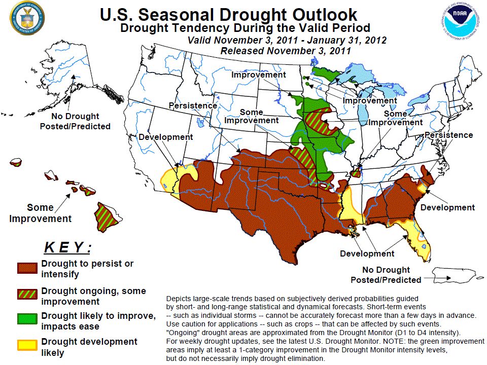
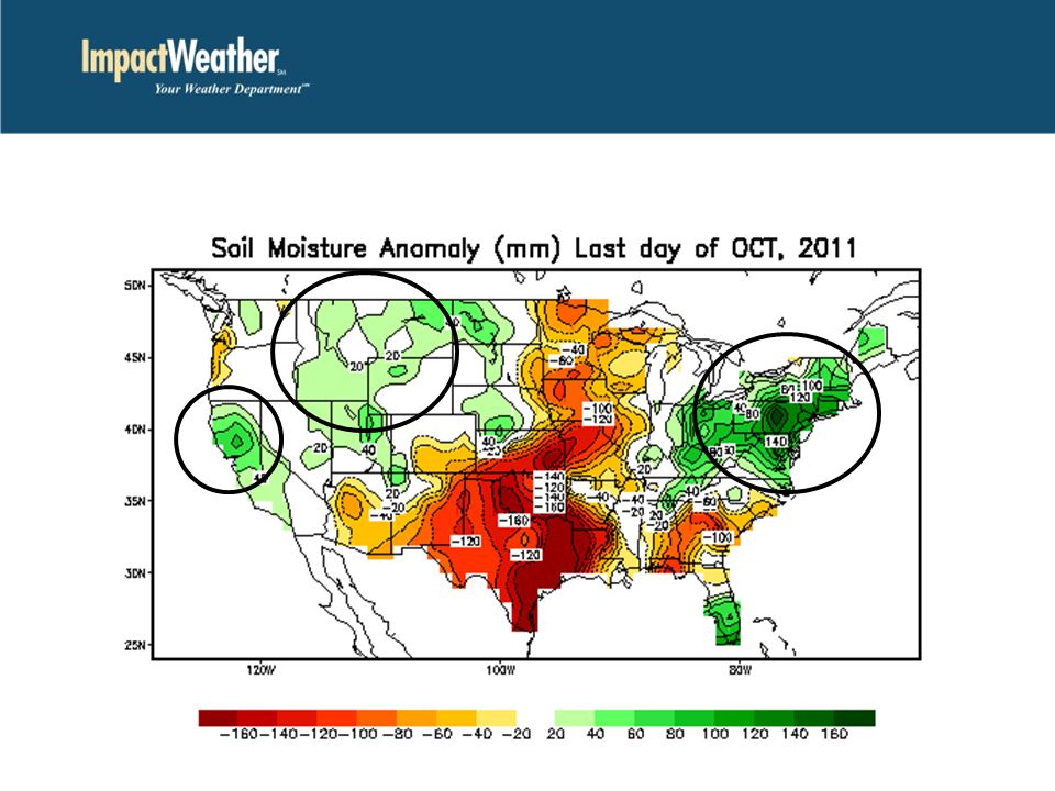
Agenda Detailed analysis of the ocean water trends and projected La Niña Brief summary of late October Snowstorm over Rockies & Northeast Forecast temperature & precipitation trends for late November and December Forecast temperature and precipitation trends for this winter season Main hazard weather trends projected for this winter season Drought outlook for Texas and Deep South Current soil moisture profiles signal another flood risk for the Ohio Valley and Northeast

5
IOD (Indian Ocean Dipole) Warm Phase
 Warm Phase")
6
IOD (Indian Ocean Dipole) Warm Phase PDO (Pacific Decadal Oscillation) Cold Phase
 Warm Phase PDO (Pacific Decadal Oscillation) Cold Phase")
7
IOD (Indian Ocean Dipole) Warm Phase PDO (Pacific Decadal Oscillation) Cold Phase ENSO (La Niña) Cold Phase
 Warm Phase PDO (Pacific Decadal Oscillation) Cold Phase ENSO (La Niña) Cold Phase")
8
IOD (Indian Ocean Dipole) Warm Phase PDO (Pacific Decadal Oscillation) Cold Phase ENSO (La Niña) Cold Phase AMO (Atlantic- Multi-Decadal Oscillation) Warm Phase
 Warm Phase PDO (Pacific Decadal Oscillation) Cold Phase ENSO (La Niña) Cold Phase AMO (Atlantic- Multi-Decadal Oscillation) Warm Phase")
11
El Niño La Niña

12
El Niño La Niña November forecast -1.4C

13
El Niño La Niña November forecast -1.4C Winter 2011-12 forecast Moderate La Nina -1 to -1.4C

14
Historic Late October NE U.S. Snowstorm Record snowstorm struck the northeast U.S. October 29-30

15
Denver 8.5” Amarillo 3.1”

16
Denver 8.5” Amarillo 3.1” Early Season Snowstorm Oct 29-30 th 12-24”...Peak at Peru, MA (32”)
")
17
Denver 8.5” Amarillo 3.1” 12-24”...Peak at Peru, MA (32”) 26 deaths 3-4 million without power Earliest heavy snow in many areas Early Season Snowstorm Oct 29-30 th
 26 deaths 3-4 million without power Earliest heavy snow in many areas Early Season Snowstorm Oct th")
18
FORECASTS

19
Colder Than Normal Warmer Than Normal Warmer Than Normal Colder Than Normal Near Normal Weather Trends for the 3rd week of November 2011 Warmer Than Normal

20
Colder Than Normal Warmer Than Normal Warmer Than Normal Colder Than Normal Near Normal Weather Trends for the 3rd week of November 2011 Warmer Than Normal STORMY Nov 14-15

21
Colder Than Normal Warmer Than Normal Warmer Than Normal Colder Than Normal Near Normal Weather Trends for the 3rd week of November 2011 Warmer Than Normal STORMY Nov 14-15 Unsettled Nov 15-16 Nov 16-17

22
Colder Than Normal Warmer Than Normal Warmer Than Normal Colder Than Normal Near Normal Weather Trends for the 3rd week of November 2011 Warmer Than Normal STORMY Nov 14-15 Unsettled Nov 15-16 Nov 16-17 Unsettled Nov 16-20

23
Lower Pressure Trend + NAO & AO phase Weather Trends for the 4 th week of November 2011 L L

24
Lower Pressure Trend + NAO & AO phase Weather Trends for the 4 th week of November 2011 LL L Lower Pressure Trend +EPO

25
Lower Pressure Trend + NAO & AO phase Weather Trends for the 4 th week of November 2011 LL L Lower Pressure Trend +EPO Higher Pressure Lower Pressure -PNA L H

26
Lower Pressure Trend + NAO & AO phase Weather Trends for the 4 th week of November 2011 LL L Lower Pressure Trend +EPO Higher Pressure Lower Pressure -PNA L H

27
Cooler than normal Weather Trends for the 4 th week of November 2011 Milder than normal Milder than normal

28
Cooler than normal Weather Trends for the 4 th week of November 2011 Milder than normal Milder than normal UNSETTLED UNSETTLED UNSETTLED UNSETTLED UNSETTLED UNSETTLED UNSETTLED UNSETTLED UNSETTLED UNSETTLED UNSETTLED UNSETTLED UNSETTLED UNSETTLED UNSETTLED UNSETTLED Milder than normal

29
Cooler than normal Weather Trends for the 4 th week of November 2011 Milder than normal Milder than normal UNSETTLED UNSETTLED UNSETTLED UNSETTLED UNSETTLED UNSETTLED UNSETTLED UNSETTLED UNSETTLED UNSETTLED UNSETTLED UNSETTLED UNSETTLED UNSETTLED UNSETTLED UNSETTLED MOSTLY DRY MOSTLY DRY DRIER Milder than normal

30
Higher Pressure Milder & Less Stormy Higher Pressure Lower Pressure Colder & More Stormy Projected Flow Pattern For December 2011 L L H H

31
Higher Pressure Milder & Less Stormy Higher Pressure Lower Pressure Colder & More Stormy UNSETTLED UNSETTLED UNSETTLED UNSETTLED UNSETTLED UNSETTLED UNSETTLED UNSETTLED Projected Flow Pattern For December 2011 L L H H

32
Higher Pressure Milder & Less Stormy Higher Pressure Lower Pressure Colder & More Stormy UNSETTLED UNSETTLED UNSETTLED UNSETTLED UNSETTLED UNSETTLED UNSETTLED UNSETTLED D R I E R Projected Flow Pattern For December 2011 L L H H

33
Colder Than Normal -3 to -6 F Colder Than Normal -2 to -4 F Colder Than Normal -1 to -3 F Near Normal Near Normal Near Normal Temperature Outlook for December 2011

34
Colder Than Normal -3 to -6 F Colder Than Normal -2 to -4 F Colder Than Normal -1 to -3 F Near Normal Near Normal Near Normal Temperature Outlook for December 2011 Colder Than Normal -1 to -3 F ? ? ? NAO Dependent Trend Definitely Negative

35
Above Normal Above Normal Above Normal Below Normal Below Normal Near Normal Near Normal Near Normal Near Normal Near Normal Precipitation Outlook for December 2011

36
Higher Pressure Milder & Less Stormy Higher Pressure Milder & Less Stormy Lower Pressure Colder & More Stormy Projected Flow Pattern For Dec 2011-Feb 2012 H L H H L

37
Higher Pressure Milder & Less Stormy Higher Pressure Milder & Less Stormy Lower Pressure Colder & More Stormy UNSETTLED UNSETTLED UNSETTLED UNSETTLED UNSETTLED UNSETTLED UNSETTLED UNSETTLED Projected Flow Pattern For Dec 2011-Feb 2012 H L H H L

38
Higher Pressure Milder & Less Stormy Higher Pressure Milder & Less Stormy Lower Pressure Colder & More Stormy UNSETTLED UNSETTLED UNSETTLED UNSETTLED UNSETTLED UNSETTLED UNSETTLED UNSETTLED Drier & Extreme Projected Flow Pattern For Dec 2011-Feb 2012 ARCTIC AIR Milder H L H H L

39
Temperature Outlook for Dec 2011 through Feb 2012 Colder Than Normal -2 to -4 F Colder Than Normal -4 to -8 F Colder Than Normal -1 to -3 F Warmer Than Normal +1 to +3 F Warmer Than Normal +2 to +4 F Near Normal Near Normal Near Normal

40
Precipitation Outlook for Dec 2011 through Feb 2012 Below Normal Below Normal Above Normal Above Normal Near Normal Near Normal Near Normal Near Normal Near Normal Near Normal

41
Hazard Concerns for the 2011-2012 Winter Stormy...Higher than normal rainfall and coastal gales! Seattle Portland San Francisco

42
Higher than normal snowfall likely Hazard Concerns for the 2011-2012 Winter Stormy...Higher than normal rainfall and coastal gales! Seattle Portland San Francisco Spokane Boise Billings Salt Lake City Reno

43
Higher than normal snowfall likely Hazard Concerns for the 2011-2012 Winter Some Drought Relief...still drier than normal! Stormy...Higher than normal rainfall and coastal gales! Seattle Portland San Francisco Spokane Boise Billings Salt Lake City Reno

44
Higher than normal snowfall likely Hazard Concerns for the 2011-2012 Winter Some Drought Relief...still drier than normal! Elevated risk of a hard freeze near the coast Stormy...Higher than normal rainfall and coastal gales! Houston Corpus Christi New Orleans Baton Rouge Tampa Jacksonville Seattle Portland San Francisco Spokane Boise Billings Salt Lake City Reno

45
Higher than normal snowfall likely Hazard Concerns for the 2011-2012 Winter Some Drought Relief...still drier than normal! Elevated risk of a hard freeze near the coast Stormy...Higher than normal rainfall and coastal gales! Houston Corpus Christi New Orleans Baton Rouge Tampa Jacksonville Seattle Portland San Francisco Spokane Boise Billings Salt Lake City Reno Lower than normal snowfall Washington D.C. Baltimore Philadelphia Wilmington

46
Higher than normal snowfall likely Elevated risk of heavier than normal snowfall Best Chance Hazard Concerns for the 2011-2012 Winter Some Drought Relief...still drier than normal! Elevated risk of a hard freeze near the coast Stormy...Higher than normal rainfall and coastal gales! Minneapolis Chicago Detroit Cleveland Buffalo Boston New York City Houston Corpus Christi New Orleans Baton Rouge Tampa Jacksonville Seattle Portland San Francisco Spokane Boise Billings Salt Lake City Reno Lower than normal snowfall Washington D.C. Baltimore Philadelphia Wilmington Best Chance

47
Higher than normal snowfall likely Elevated risk of heavier than normal snowfall Best Chance Hazard Concerns for the 2011-2012 Winter Some Drought Relief...still drier than normal! Elevated risk of a hard freeze near the coast Stormy...Higher than normal rainfall and coastal gales! Minneapolis Chicago Detroit Cleveland Buffalo Boston New York City Houston Corpus Christi New Orleans Baton Rouge Tampa Jacksonville Seattle Portland San Francisco Spokane Boise Billings Salt Lake City Reno Washington D.C. Baltimore Philadelphia Wilmington Best Chance Elevated freezing Rain risk Dallas Oklahoma City Little Rock St. Louis Kansas City Memphis Nashville Indianapolis Columbus Pittsburgh Philadelphia Lower than normal snowfall

49
Abnormally Dry (yellow)
")
50
Moderate Drought (tan) Severe Drought (red)
 Severe Drought (red)")
51
Abnormally Dry (yellow) Moderate Drought (tan) Severe Drought (brown) Severe Drought (red) Severe Drought (red)
 Moderate Drought (tan) Severe Drought (brown) Severe Drought (red) Severe Drought (red)")
52
Abnormally Dry (yellow) Moderate Drought (tan) Severe Drought (brown) Severe Drought (red) Exceptional Drought (dark red) Severe Drought (red)
 Moderate Drought (tan) Severe Drought (brown) Severe Drought (red) Exceptional Drought (dark red) Severe Drought (red)")
58
Late season snowmelt could lead to flash flooding early in 2012

59
Questions

60
Worldwide weather forecasting and notification 24/7 Seasonal outlook forecasting Severe terrestrial weather monitoring and automated notification Offshore/marine forecasting year-round Customized weather websites Direct consultation with a meteorologist Business Continuity, Employee Resiliency and Response Plan Consulting Webinar Questions: fschmude@impactweather.com More information (877) 792-3220 sales@impactweather.com
")
61
acp-international.com The ACP Webinar Series: Critical Elements of Voice Communications Recovery Thursday, December 1, 2011 2:00 PM - 2:30 PM CST Register at: tiny.cc/y8djz

Similar presentations


 – current and future state ENSO phase composites for upcoming winter temperature precipitation Climate Prediction.>")


 The Arctic Oscillation: Opposing atmospheric pressure patterns in northern middle and high latitudes. “Positive phase in which.>")


 is an index derived from North Pacific sea surface temperature anomalies and it has a high correlation to.>")

