Download presentation
Presentation is loading. Please wait.

1
Transport for a Growing City

2
Derby is a city of 249,000 citizens and growing, it has increased by 19,000 between 2001 and 2011 (last census) The population of greater Derby is about 300,000. It is home to many high tech industries, and has the highest proportion of technically qualified employees in Britain. Transportation is a major sector, including Rolls-Royce, Bombardier, and Toyota.

3
Most employment is in large industrial sites or business parks. This means that transport flows are not centred on one place, such as the city centre. Congestion is often worse in areas near the outer ring road. Buses only account for 5.5% of travel to work journeys.

4
Buses only serve the city centre; industrial and business sites and out-of-town shopping is ignored. Presumably the peaky nature of travel to work journeys is unattractive to bus operators with low capacity vehicles and few spare buses, and difficult to staff. No cross-city routes; and two operators making co- ordination difficult. Lack of early buses is unsuitable for industrial start times. Poor reliability at peak traffic times, frequencies on some routes are actually REDUCED in the afternoon peak! Fares are high, especially when vehicle change is required. No central interchange point, the bus station is not used by many routes.

5
Much better public transport is required to improve existing travel, let alone cope with growth, unless Derbys future is jeopardised. 19,000 new houses are planned in the greater Derby area, with a further 25,000 in the Derby travel to work area; along with a large new high tech business park. These will put a very heavy strain on an already overloaded road system. Better public transport will aid growth in the city centre, an aim of the council; traffic and parking problems are a great disincentive.

6
Provide a tram system that will serve the major traffic generators, and be suitable for Derbys travel pattern. As well as providing suburb to centre travel, it will also provide services to the main out of town sites. Make inter-suburb travel a practicality with public transport. Be largely separated from road traffic to give reliability and fast journeys.

7
Derbys roads are mostly relatively narrow, based on a road pattern that is centuries old, for what was a market town. Public transport needs to have its own right of way to be reliable. A tramway makes the most economical use of space. It is environmentally attractive, and energy efficient. Trams have a proven record of attracting passengers.

8
Westfield, City Centre. 74,000 per day. Rolls-Royce. 11,000 employees, mainly on one site. Royal Derby Hospital. About 10,000 per day. Pride Park, Wyvern, Raynesway. About 10,000 workplaces; in addition are the football stadium and new Arena, with a total of 35,000 seats. Railway Station, about 3,000 passengers per day. University, about 11,000 students on three sites. Derby College. Probably about 5,000 students per day at the Roundhouse and Joseph Wright Centre.

9
A series of interconnected loops will allow for travel between outer areas, and give much better coverage of them. This will connect housing and industrial areas, especially in the south. It will allow for the planned development of 19,000 new houses that would otherwise put even greater strain on an already overloaded road system.

11
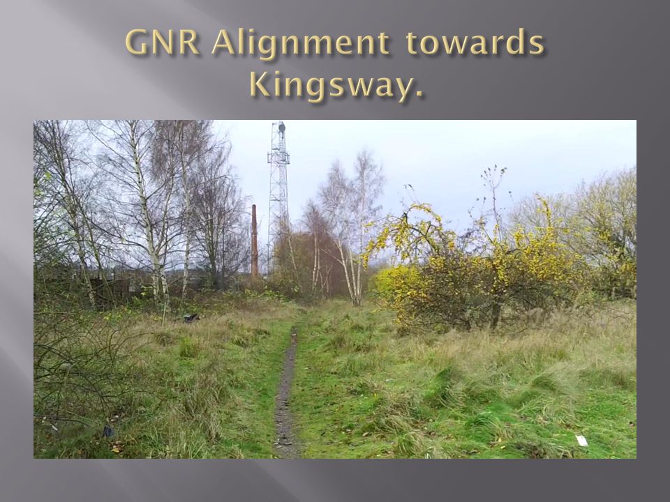
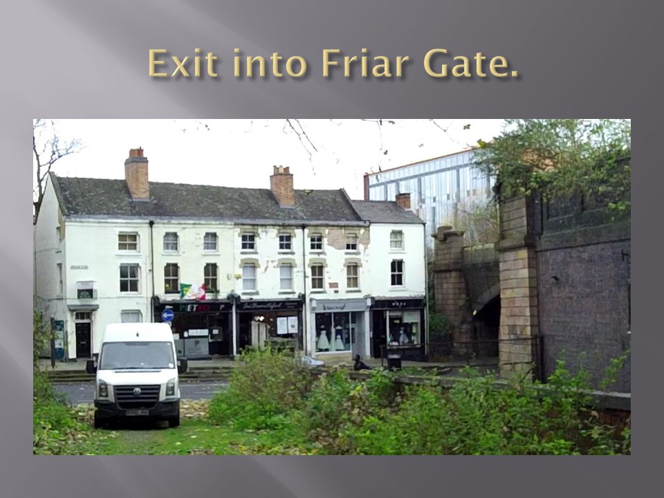
Line 1 utilises the alignment of the old Great Northern Railway from the site of Friar Gate station in the city centre out to Kingsway, about 2Km. From Kingsway, it forms a bi-directional loop, serving Mackworth, Mickleover and the Royal Derby hospital. This section will use roadside running as far as possible, though some short off-road sections will be possible. It will include large sections of single track with loops, a system well used in the original Nottingham lines. From Friar Gate in the city centre, it will largely be on- street, but largely separated from traffic. From the city centre to the station, it will follow an under construction boulevard through the Castleward urban village development.

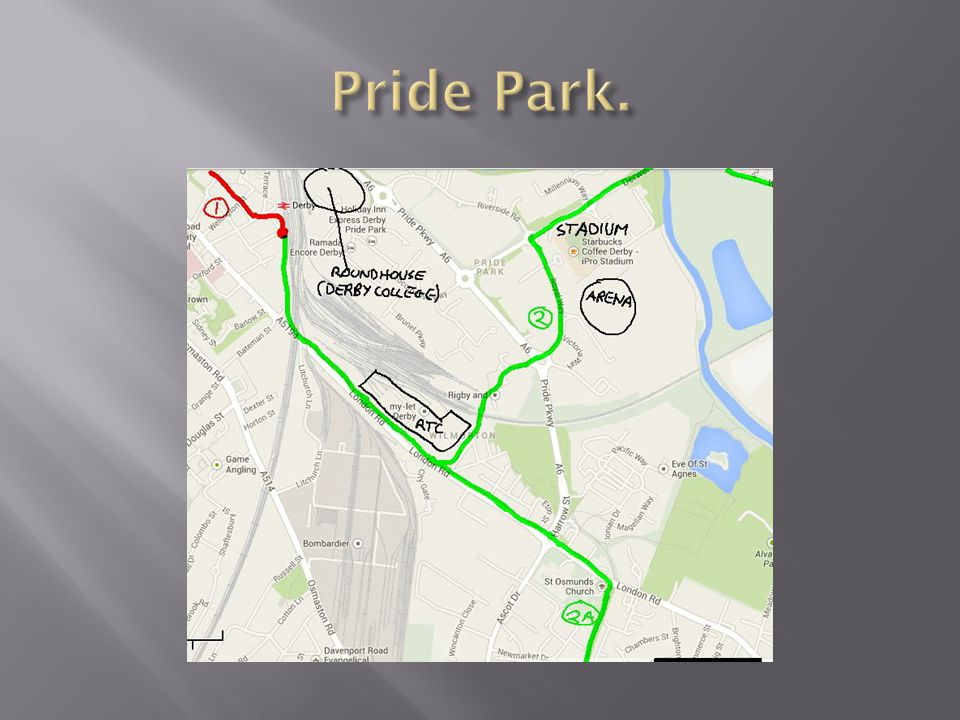
12
Line 2 will go from the station via Pride Park, a major business park and sporting centre, and then form a loop through Alvaston and Chellaston and the Rolls- Royce site, and return to the station alongside the Derby-Birmingham main line. It will also serve new housing developments in the Boulton Moor area, and the Infinity high tech business park adjacent to Rolls-Royce that has just been started, and is destined to have 8,000 workplaces. There is also the possibility of an inner loop being formed by use of the alignment of a former canal, presently a walkway. This would serve more existing housing, and also the Ascot Drive industrial estate.

13
Line 3 is a loop connected to Line 2. It starts from Rolls-Royce, and goes through the new Infinity Park, and then on to Sinfin and Stenson Fields, serving both new and existing housing. It then goes through Sinfin district centre, and then alongside the Birmingham line to re-join Line 2 at Peartree.

14
This is another loop, between Lines 3 and 1. It leaves Line 1 at Sinfin, crossing the railway by an existing bridge into Sunny Hill It will then follow the boundary of existing and new housing in Heatherton, and then into a part of Littleover, joining Line 1 at Corden Avenue. It will serve Littleover School, one of Derbys largest.

15
Line 5 leaves Line 2 at Raynesway, passing the large ASDA supermarket, and following Acorn Way north; there is a planning application for 250 houses here. Beyond here a branch to Spondon will follow at West Road. The main line will continue along Acorn Way, and turn into Chaddesden at Brook Farm, where there is an application for 200 houses, then follow Morley Road into Oakwood, a large suburb built in the 80s and 90s. A loop through Oakwood will go to the Meteor Centre, an out-of town retail park, and then return to the City centre serving other parts of Chaddesden, and businesses in The Pentagon area.

16
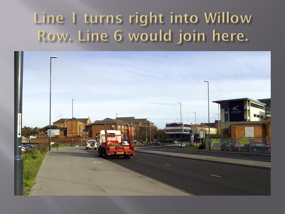
This leaves Line 1 at Willow Row, and goes through a housing area to two University sites, also serving student accommodation. It then goes cross country through a former school site to Kedleston Road and the main University site. Kedleston Road is then followed on a roadside reservation to Allestree. A loop around Allestree serves the Park Farm shopping centre, a secondary shopping centre at Blenheim Parade, Woodlands School, and then back to Kedleston Road.

17
Lines 1 & 2 should both attain about 23,000 trips per day. Line 2A would have itself about 5,000. Line 3 would be about 12,000. Line 4 would be about 8,000. Line 5 would be about 14,000. Line 6 would be about 11,000. These figures include the future developments. This mainly affects Lines 2,3,4. They are based on attaining a 20% share of trips of the population living within 400m of the route, and a similar share of movements to major traffic objectives on route. The figures are for each line itself; the network effect will mean that some of the traffic on one line will also be reflected in an increase on parts of others, notably the central section of Line 1.

18
Line 1 would be Phase 1, as it forms the central section. Use of the former Great Northern railway alignment also makes it the easiest way of exiting the city centre. It has an estimated 23,000 trips per day, and serves major traffic objectives and two major suburbs. Line 2 also has an estimated 23,000 trips per day, but this is dependant on the building of about 3,700 planned houses. It should be Phase 2, as it serves the major employer, Rolls-Royce. Line 2A is an alternative way of getting to RR, and should be extended to Chellaston, using some of Line 2. Pride Park should be included, possibly initially as a spur. The rest of Line 2 could be built later. Line 6 has about 11,000 trips, and is a mature area, though there is some planned development outside the city boundary. It includes three university sites, and much student accommodation. On a passenger per Km basis it comes out very well. This should be Phase 3.

19
Line 3 has about 12,000 trips per day, but is dependent on Line 2, and completion of new housing and the Infinity park. It should then be Phase 4. Line 4 would have about 8,000 trips per day, again dependant on new housing completion. It is relatively short, and a lot would be in new areas, so should be relatively easy. This should therefore be Phase 5 Line 5 has about 14,000 trips per day, but it is relatively long. It could be improved by addition of an inner loop through Chaddesden. A lot of it would have to be street based. This makes it Phase 6.

20
Ideally, Pride Park would be accessed by a crossing of Derby Station, giving a direct connection. However, such a crossing would be a major and costly civil engineering operation. Alternatives have been considered using existing crossings of the railway. There is an underpass north of the station that was an access for the former loco works. This now forms a pedestrian access to Pride Park, but recent road reconstruction has made it only accessible by a stairway. Changing this back to level access would be prohibitively expensive.

21
Pride Parkway also crosses at this point on a viaduct, but accessing this would be difficult, and would mean that the main station entrance would be missed. It would also entail street running on a busy road. The Birmingham line could be crossed by use of London Road bridge, which is currently being replaced. This leaves the London line to be crossed; an existing underbridge at Deadmans Lane could be used. This would mean following London Road past the former Railway Technical Centre, now known as the RTC Business Park. This has a lawned frontage that could take grass tracks. This route gives a 1Km detour, but serves the RTC. This routing also gives access to Line 2A.

27
Unfortunately, this now ends abruptly, the former connecting viaducts being removed. Ideally it would be reinstated, and a new viaduct built to cross the inner ring road, but would be prohibitively expensive, so going down to road level is more likely.

56
The bridge shown went under the original Kingsway, but was filled in when the new A38 was built, which is to the right. The line will come to street level here and diverge. It will cross Kingsway here and continue roughly ahead to the Royal Derby and beyond. The Mackworth section will follow the path shown towards the camera.

62
A large reduction of cost is the aim. No large scale civil engineering will be used, existing structures being utilised. Large amounts of single track will be used; the loop route pattern aids this. Services will alternate in direction. Passing loops will be provided to make a good frequency possible. Most track will be on reservation, on roadside verges in many places. Grass track will give minimal environmental impact in suburban areas. Street running in the city centre is along largely pedestrianised areas. In a few places, street running amongst general traffic will be necessary, but will largely be on lightly trafficked roads.

63
In some places, major roads have to be crossed. This will be by light-controlled crossings. Linking these with adjacent pedestrian crossings would reduce impact on other traffic. Track would be simple, no massive concrete rafts. Dutch type construction or the PCAT system is preferred. This will allow access to utilities, largely removing the need for utility diversion. The PCAT system only needs very shallow excavation. The loop system will still allow operation on both sides of any utility disruption. Kletterweiche and temporary track could also be used.

64
Vehicle weight reduction would be a major specification aim. Permanent magnet motors would be a requirement for energy reduction. Independent wheels would be a requirement to give good curving performance, small radius curves reducing infrastructure cost. Energy storage on the vehicles would be a requirement as this considerably reduces the electrical infrastructure. (Current peaks are smoothed out, up to ten-fold, and regeneration is maximised.) This removes any need for track insulation. Energy storage will allow limited operation off-wire, easing use of temporary track.
 This removes any need for track insulation. Energy storage will allow limited operation off-wire, easing use of temporary track..")
65
The minimum frequency should be five trams per hour per direction during the working day, which should at least extend between 06-30 to 19-00 Monday to Saturday. Outside these hours, minimum frequency should be three trams per hour, between 06-00 to 00-00. A night service should also be considered. Public transport must adjust to the 24/7 lifestyle, and offer a good alternative to the car.

66
This is planned to serve the East Midlands by a station at Toton, almost midway between Nottingham and Derby. At present, it is not certain, there being much opposition. Derby City Council want it to come through Derby. If Toton is finally built, a fast tramway connection to Derby is desirable. (Nottingham already plan to extend NET to it.) This could leave Line 2 at Raynesway, and follow the A52 road. There would be a small detour at Spondon to serve a new business park planned on the old Celanese site. A stop would serve Borrowash and Ockbrook.
 This could leave Line 2 at Raynesway, and follow the A52 road. There would be a small detour at Spondon to serve a new business park planned on the old Celanese site. A stop would serve Borrowash and Ockbrook..")
67
A connection would be provided to allow through Derby – Nottingham services. An short extension from Toton into Long Eaton would extend coverage of both the Derby tramway and NET. This tramway would offer relief to the overloaded A52 road. There are currently more than six express buses per hour between Derby and Nottingham, along with another six per hour locals via Long Eaton and Sandiacre, along with four trains on the more indirect railway.

68
There is a Toyota car plant 13Km outside Derby, employing about 5,000. This could be accessed by a connection with Line 1 at Mickleover. It would largely use more of the old GNR trackbed. It would be made more viable by a further 2Km extension to Hilton. Hilton is an expanding village, with a population of about 10,000, which will be considerably increased by planned new housing. The line would pass through Etwall, another expanding village with a population of about 2,000. This area, South Derbyshire, is set for growth, a lot of the planned 25,000 houses will be here.

69
An inner loop through Chaddesden has already been seen as a possibility. The inner south-west of the city is unserved, identifying a possible route would be desirable. The east of Allestree and more of Darley is unserved, a possible route is using Broadway and then Duffield Road, and then into the Home Farm estate.

70
It would be desirable for bus operators to be involved in the tramway, rather than providing wasteful competition. Ideally, shuttle buses would operate around suburbs, connecting with trams. Park and Ride should be provided on the perimeter of the city near major main roads. Possible sites are off Raynesway (Line 2), serving the A6, A50 and A52 east. At Kingsway (Line1), a site would serve the A38, A52 west, and A516. The A38 could also be served by a site off Line 4 at Heatherton.
, serving the A6, A50 and A52 east. At Kingsway (Line1), a site would serve the A38, A52 west, and A516. The A38 could also be served by a site off Line 4 at Heatherton..")
Similar presentations


,>")