Download presentation
Presentation is loading. Please wait.

1
Map Skills

2
Bell Ringer- Monday What is the purpose of a map?

3
Objectives Locate: – All 7 Continents – Determine the difference between Political and physical maps – Review directions (compass rose)
")
4
Reminders Syllabus- get that sheet signed for tomorrow Review your syllabus for your quiz tomorrow Vocab due THURSDAY See me in room 236 if you need anything after school

5
Pg. 1 What is a map? A map is used for: – To get direction from one place to another – Understanding distance between two points – Defining boundaries between different countries – Show geographical features

6
History of Maps Have been created in various forms throughout human history Were used to determine distance between two points, draw political boundaries between different countries, and most importantly, to show people how to get from one place to another in the most efficient way possible.

7
Star Maps- The 1 st Maps Depending where on Earth a person is, the orientation of the star map changes. Star maps were some of the earliest maps used to help humans figure out where they were going.

8
Early Geographic Maps Early maps reflected the best understanding of cartographers of the time period. That being said, they were oftentimes very inaccurate. In many instances, maps would include images of monsters, which were placed on the maps to show/explain dangers that existed.

9
Maps continue to improve As time went on, mapping tools and understanding of the shape of the Earth continued to improve, and so too did the ability of map makers to draw more accurate maps.

10
Modern Day Maps Today, we have the ability to use satellites in order to create the most accurate maps available.

11
Types of Maps

12
Political Maps Political maps show boundaries between continents, countries, states, and cities.

13
Physical Maps Physical maps show physical features of the Earth, such as mountains, deserts, rivers, forests, etc. These maps can tell us a lot about the region included in the map, such as the climate of particular region.

14
Combo Maps Some maps, such as the one to the left, combine political maps (see the boundaries of each state) with physical maps (see the Rocky Mountains in the western portion of the US).
 with physical maps (see the Rocky Mountains in the western portion of the US).")
15
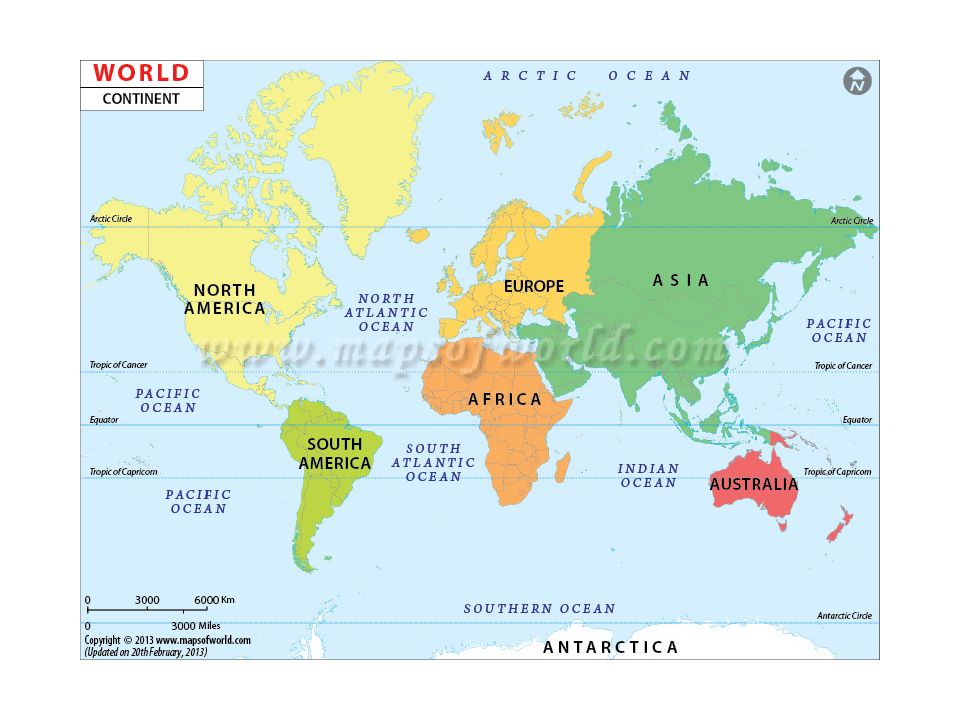
Continents and Oceans

16
What are they? Continents Any of the world's main continuous expanses of land 7 continents – Europe, Asia, Africa, North America, South America, Australia, Antarctica Oceans A very large expanse of sea – Contain salt water, not fresh water 5 oceans – Atlantic, Pacific, Indian, Arctic, Southern

18
Compass Rose

19
Types of Directions Cardinal Directions North (N), East (E), South (S), West (W) Intermediate Directions Northeast (NE), Southeast (SE), Southwest (SW), Northwest (NW)
, East (E), South (S), West (W) Intermediate Directions Northeast (NE), Southeast (SE), Southwest (SW), Northwest (NW)")
20
Exit Slip What continent is the USA located in? What direction would you travel if you were going from Africa to North America?

21
Latitude and Longitude

22
Bell Ringer-Tuesday-Take out a sheet of paper-Syllabus QUIZ! 1. What rooms will you find Ms. Maneck in? 2. Can you email Ms. Maneck asking for help? 3. Do I allow you to plagiarize your work? 4. True or False: Ms. Maneck is very strict and won’t help you or work with you if you are having problems in class.

23
Objectives Review latitude and longitude- practice by locating American cities on a map Locate/review hemispheres Locate/review equator and prime meridian OK…now, get your maps out from yesterday and your notes!

24
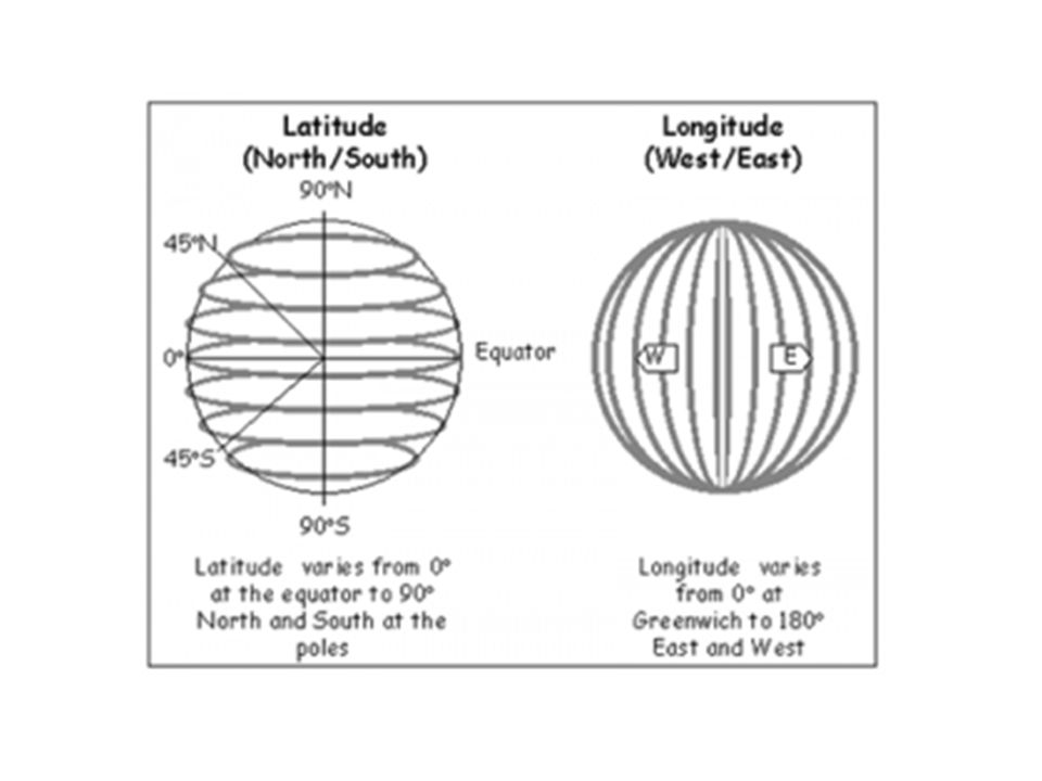
How to find a specific location While a compass is important for finding ones directions, it can’t tell you where something is located. Therefore, a system is needed to pinpoint the location of a person, place, or thing. In order to do this, we created a system of lines that go from East to West (Latitude) and lines that go from North to South (Longitude) that divided the globe into a grid.
 and lines that go from North to South (Longitude) that divided the globe into a grid..")
25
Pg. 2 Measuring distance using Latitude and Longitude The unit of measurement when finding latitude and longitude is called degrees. The symbol for degree is °. – 10 degrees North = 10° N

26
Lines of Latitude Lines of latitude go from East to West. – Are called Parallels They measure distance from North to South. An easy way to remember which way latitude goes is that “Lat is fat.” Another way to think about it is that lines of latitude are like a belt around the planet.

27
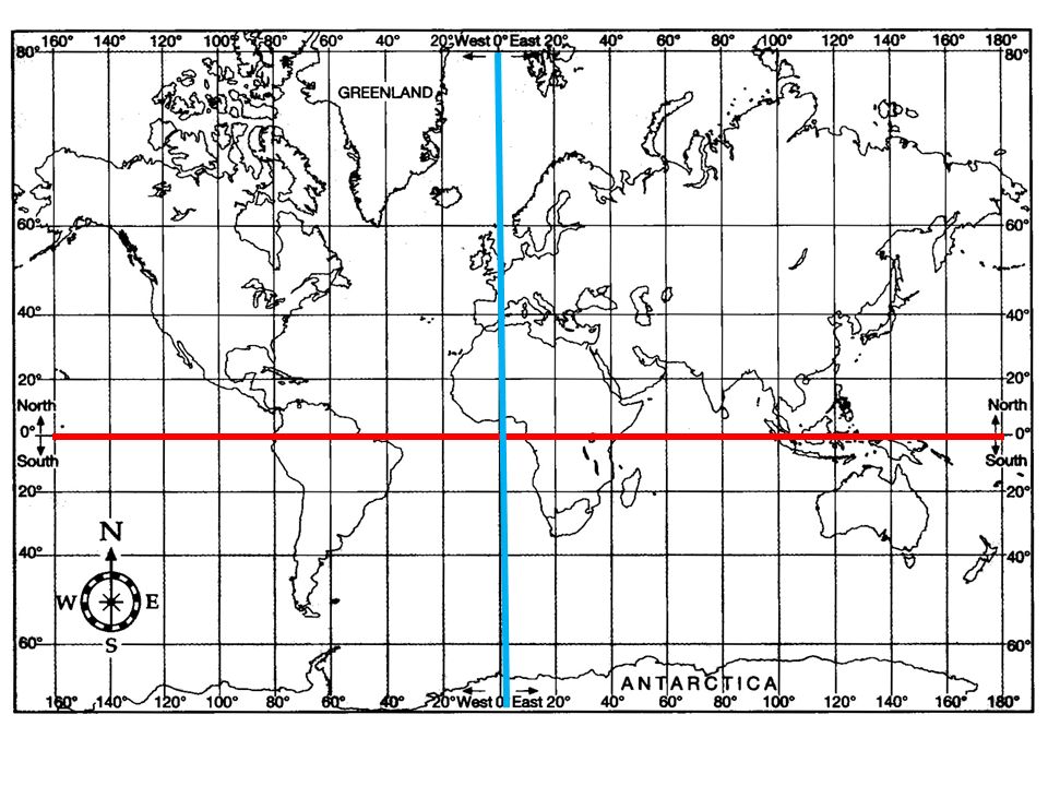
Lines of Latitude continued The line that goes across the center of the Earth from East to West is called The Equator – Equator = 0° Everything to the North of the Equator is in the Northern Hemisphere – The North Pole is located at 90° N and is the top of the Earth Everything to the South of the Equator is in the Southern Hemisphere – The South Pole is located at 90° S and is the top of the Earth

29
Lines of Longitude Lines of longitude go from North to South. – Are called Meridians They measure distance from East to West. An easy way to remember this is that longitude is long, stretching from top to bottom of the globe.

30
Lines of Longitude continued Just like the equator is 0° N/S, the line that divides East (E) from West (W) is called the Prime Meridian and is 0° E/W. From the Prime Meridian, one can go 180° to the East or West. – 0°-180° E= Eastern Hemisphere – 0°-180° W= Western Hemisphere

31
Mark prime meridian and equator on your map

34
Absolute and Relative Location Absolute Location: Location that is SPECIFIC. Example: an address or coordinates (41 * N, 87* W) Relative location: an approximation (something close) Example: I live at Damen and Chicago Ave.
 Relative location: an approximation (something close) Example: I live at Damen and Chicago Ave..")
35
Let’s practice Latitude/Longitude and Absolute/Relative location You may work with a partner but please do your own worksheet (it is double sided. I will ask you to share out in about…15 min

36
Exit Slip- turn in for grade with your worksheet Lines of latitude run: Lines of longitude run: Give me an example of relative location Give me an example of absolute location

37
Bell Ringer-Wednesday What do you know about a primary source? What do you know about a secondary source?

38
Objectives Determine the difference between a primary and a secondary source Learn to analyse primary sources (using the 6 c’s)
")
39
Reminders Syllabus signature sheet due today Get your supplies to me by Friday Get your vocab done by Thursday!!

40
Primary Sources

41
Secondary sources

42
Practice

43
Analyse Primary Sources What does it mean to analyse? Why do we analyse?

44
Analysis Practice Use the 6 C’s Today we will do a picture—tomorrow will be a quote. Will the analysis be any different between the two?

Similar presentations


>")


, East (E), South (S), and West (W). A good way to remember the.>")
