Download presentation
Presentation is loading. Please wait.

1
China EO Systems and its policy Jinlong Fan Research Scientist National Satellite Meteorological Center China Meteorological Administration PEOIC workshop, Nov 9-10,2015 Tokyo, Japan

2
Overview of China EO Systems Gu XF,2015

3
China EO System of Systems Meteorological satellite series Oceanic satellite series TanSat - co2 China Seismic-Electromagnetic Satellite mission HJ – Environment and Disaster ZY – Resource CBERS – Resource BJ – DMC commercial GF series – high resolution JiLin -1 – commercial

4
Chinese Meteorological Satellite: FengYun Programme Polar Orbiting SeriesGeostationary Series FY| 1A 1A 1B 1B 1C 1C 1D 1D FY | 3A 3A 3B 3B 3C 3C 3F 3F FY| 2A 2A 2B 2B 2C 2C 2D 2D 2E 2E 2F 2F 2G 2G FY FY | 4 Second Generation First Generation FengYun or FY stands for Chinese meteorological satellite. Feng means wind in English and Yun cloud.

5
Launched Satellites

6
In-orbit assets FY-2G 105 Chinese Meteorological Satellite: FengYun Programme

7
Global data Latency within 4 hours maximum

8
FY-3C VIRR globle mosaic FY-3C MERSI globle mosaic Instruments onboard FY-3A,3B and 3C: VIRR (Visible and Infrared Radiometer) MERSI (Medium Resolution Spectral Imager) IRAS (Infrared Atmospheric Sounder) MWTS Ⅱ (Microwave Temperature Sounder Ⅱ ) MWHS Ⅱ (Microwave Humidity Sounder Ⅱ ) SBUS (Solar Backscattering UV Sounder) TOU (Total Ozone Unit) MWRI (Microwave Radiation Imager) ERM (Earth Radiation Measurement) SEM (Space Environment Monitor) SIM Ⅱ (Solar Irradiation Monitor Ⅱ ) GNOS (GNSS Occultation Sounder) Payloads VIRR: Visible and Infra-Red Radiometer MERSI: Medium Resolution Spectral Imager Spatial Resolution from 1 Km to 250m
 MERSI (Medium Resolution Spectral Imager) IRAS (Infrared Atmospheric Sounder) MWTS Ⅱ (Microwave Temperature Sounder Ⅱ ) MWHS Ⅱ (Microwave Humidity Sounder Ⅱ ) SBUS (Solar Backscattering UV Sounder) TOU (Total Ozone Unit) MWRI (Microwave Radiation Imager) ERM (Earth Radiation Measurement) SEM (Space Environment Monitor) SIM Ⅱ (Solar Irradiation Monitor Ⅱ ) GNOS (GNSS Occultation Sounder) Payloads VIRR: Visible and Infra-Red Radiometer MERSI: Medium Resolution Spectral Imager Spatial Resolution from 1 Km to 250m")
9
9 2008FY-2E 2008FY-3A (R&D) 2011FY-2F 2010FY-3B (R&D) 2012FY-3C(Op) 2014FY-3D(Op) 2013FY-2G 2014FY-4A (R&D) 2016FY-3E(Op) 2016FY-RM(R&D) 2017FY-4B (Op) 2018FY-3F(Op) 2020FY-RM22019FY-4C(Op) 2015FY-2F Road Map of FENGYUN Satellites by Year 2020
 2011FY-2F 2010FY-3B (R&D) 2012FY-3C(Op) 2014FY-3D(Op) 2013FY-2G 2014FY-4A (R&D) 2016FY-3E(Op) 2016FY-RM(R&D) 2017FY-4B (Op) 2018FY-3F(Op) 2020FY-RM22019FY-4C(Op) 2015FY-2F Road Map of FENGYUN Satellites by Year 2020")
10
Chinese Oceanic Satellite Series Oceanic Satellite Series(HY) HY-1A ( 2002.05 ) HY-1B ( 2007.04 ) HY-2 ( 2011.08 ) Ocean pollution monitoring Coastline survey Ocean resource exploration Ocean dynamic
 HY-1A ( ) HY-1B ( ) HY-2 ( ) Ocean pollution monitoring Coastline survey Ocean resource exploration Ocean dynamic")
11
TanSat mission Funded by MOST, CAS and CMA

12
China Seismic- Electromagnetic Satellite mission

13
China-Brazil Earth Resource Satellite ( CBERS )
")
14
Land resource survey Mineral resource survey Cities Delicacy Management Agriculture, forestry, water resource monitoring ZY-3 Surveying and Mapping Satellite, Spatial Resolution of 2.1m, Multispectral Scanner(IRMSS) With Spatial Resolution of 5.8m ZY-1-02C ( 2011.12 ) ZY-3 ( 2012.01 ) Resources Satellite ( ZY ) Chinese Resource Satellite
 With Spatial Resolution of 5.8m ZY-1-02C ( ) ZY-3 ( ) Resources Satellite ( ZY ) Chinese Resource Satellite")
15
HJ-1A ( 2008.09 ) HJ-1B ( 2008.09 ) HJ-1C ( 2012.09 ) Surface water quality and atmosphere environment monitoring Disposal of major environmental pollution event Monitoring, assessment, and emergency response of major natural disaster Environment and Disaster monitoring satellite constellation
 HJ-1B ( ) HJ-1C ( ) Surface water quality and atmosphere environment monitoring Disposal of major environmental pollution event Monitoring, assessment, and emergency response of major natural disaster Environment and Disaster monitoring satellite constellation")
16
Bejing-1 launched October 27,2005 Bejing-2 launched July 10,2015 BeiJing 1,2 DMC small satellites

17
China’s high-resolution Earth observing system (CHEOS) Started in 2010 to provide Near Real Time data for disaster, climate change, geographical mapping, environment and resource surveying, as well as for precision agriculture.
 Started in 2010 to provide Near Real Time data for disaster, climate change, geographical mapping, environment and resource surveying, as well as for precision agriculture.")
18
GF-1 launched 2013 and provides 2m Pan/8m MS/16m MS GF-2 launched 2014 and provides 1m Pan/4m MS GF-3 is a high-resolution radar satellite GF-4 is an optical geostationary satellite GF-5 is a high spectral and atmospheric observation satellite GF-6 is a multi-spectral satellite and GF-7 is a three-dimensional mapping satellite These satellites are planned to be launched and put into service before 2020. China’s high-resolution Earth observing system (CHEOS)
.")
19
Jilin1 Satellite for commercial remote-sensing services Chang Guang Satellite Technology Co., Ltd, sponsored by the Jilin provincial government, the Changchun Institute of Optics, Fine Mechanics and Physics of the Chinese Academy of Sciences and some privately- owned companies, plans to launch 60 satellites by 2020 and 137 by 2030. one optical remote-sensing satellite, launched on Oct. 7, 2015 two satellites for video imaging and another for imaging technique testing

20
China High resolution satellite data policy released Key point: 1m

21
China national civil space infrastructure middle and long term development plan(2015-2025) Released Main components -Satellite remote sensing system -Communication satellites -GPS system -with international cooperation
 Released Main components -Satellite remote sensing system -Communication satellites -GPS system -with international cooperation")
22
Web link http://satellite.cma.gov.cn/portalsite/default.aspx?currentculture= en-US

23
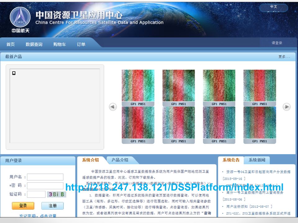
http://218.247.138.121/DSSPlatform/index.html
24
http://rs.ceode.ac.cn/remotsensingNetwork.jsp

25
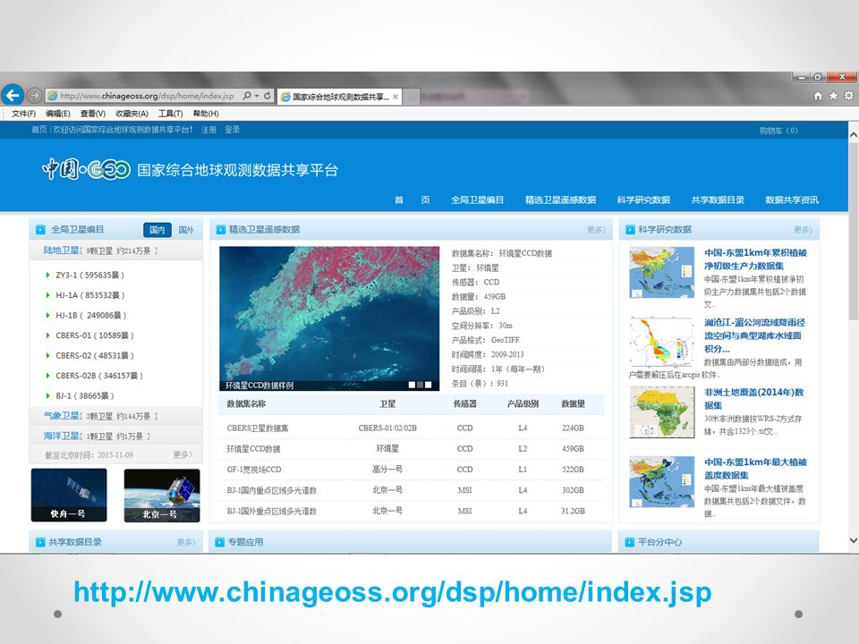
http://www.chinageoss.org/dsp/home/index.jsp
26
Thank you for your attention!

Similar presentations


![Agency, version?, Date 2014? [update filed in the slide master] Coordination Group for Meteorological Satellites - CGMS Add CGMS agency logo here (in the.](/13/3734551/big_thumb.jpg "Agency, version?, Date 2014? [update filed in the slide master] Coordination Group for Meteorological Satellites - CGMS Add CGMS agency logo here (in the.>")
 China Meteorological Administration.>")


-Polar Orbiting Environmental Satellite (POES) Orbital characteristics.>")

 which was also the beginning.>")
 Oct.22-Nov.2 Beijing China.>")


