Download presentation
Presentation is loading. Please wait.

2
Water Cycle Earth has continuously been recycling water since the outgassing of water early in its history. Water Cycle = constant recirculation of water at and near Earth’s surface.

3
Infiltration

4
How does water get from the surface to the atmosphere? Evaporation – liquid to gas – Returns water to the atmosphere – Driven by solar radiation Transpiration – plants release water vapor directly into the atmosphere. Evapotranspiration – combination of the two processes.

5
Where is most of the water vapor located? ESRT page 14

6
How does water get from the atmosphere to the surface? Condensation – gas to liquid – Leads to cloud formation Precipitation – falling liquid or solid water from a cloud. – Rain, Snow, Sleet, Hail – Precipitation leads to higher atmospheric transparency

7
Precipitation will wash these particles out of the sky! Don’t eat snow or rain! It may contain some of these potentially dangerous particles!

8
What happens to water once it reaches the surface? Two possibilities… Infiltration – water “seeps into” the ground – Groundwater = water below the surface and that is stored in pore spaces – NOT underground lakes/streams! Runoff – water travels downhill, over the ground surface into rivers, streams, etc. Inverse Relationship!

9
A model of an Aquifer System Beneath the water table, all of the pore spaces between the grains are completely saturated with water (groundwater)
")
10
Profile Through the Earth’s Surface Saturated Zone (groundwater) Unsaturated Zone
 Unsaturated Zone")
11
1) Slope – the steeper the slope, the lower the infiltration (inverse relationship)
 Slope – the steeper the slope, the lower the infiltration (inverse relationship)")
12
2) Degree of Saturation – land will allow infiltration up to the point that the land becomes saturated with water (all of the pore spaces are filled with water)
 Degree of Saturation – land will allow infiltration up to the point that the land becomes saturated with water (all of the pore spaces are filled with water)")
13
3) Porosity - the PERCENTAGE (%) of open spaces in a material compared to its total volume. Shape, packing and sorting of particles determine the porosity of loose materials.

14
Porosity Angular Round a. Shape – rounder particles have a higher porosity

15
b. Packing – particles that are loosely packed have a higher porosity Porosity Degree of Packing

16
Porosity Well Sorted Poorly Sorted c. Sorting – particles that are well sorted have a higher porosity Well-Sorted Poorly-Sorted

17
d. Particle Size – if particles of a soil sample have a uniform shape and packing, particle size will NOT affect porosity. Particle Size Porosity

18
In Summary Soils that have round particles, are loosely packed, and are well sorted (same particle sizes) will be very porous! Soils that have angular particles, are closely packed, and are poorly sorted (various particle sizes) will not be porous!
 will not be porous!.")
19
4) Permeability – RATE at which a porous material (such as rock or soil) will allow fluids to pass through it Permeability Grain Size Permeability Sorting Closely packed Loosely packed Permeability
 Permeability – RATE at which a porous material (such as rock or soil) will allow fluids to pass through it Permeability Grain Size Permeability Sorting Closely packed Loosely packed Permeability")
21
Capillarity – the process by which water is drawn upward into openings, due to the attractive force between water molecules and the surrounding Earth materials. The smaller the opening the greater the capillary action. Particle Size Capillarity

22
Climate

23
Climate vs. Weather Weather – atmospheric conditions that occur at a particular place during a short period of time. Climate – the average weather conditions in a region over a long period of time (years). – Climate is based upon the moisture, temperature and the types of vegetation of a region.
. – Climate is based upon the moisture, temperature and the types of vegetation of a region..")
24
Climate Classification Criteria Average monthly temperatures Average monthly precipitation Total annual precipitation

25
Factors that affect Climate Latitude Altitude (elevation) Large Bodies of Water Ocean Currents Mountains (Orographic Effect) Planetary Winds
 Large Bodies of Water Ocean Currents Mountains (Orographic Effect) Planetary Winds")
26
1) Latitude The latitude of a location determines the Angle of Insolation and Duration of Insolation Areas near the Equator receive more direct sunlight and are warmer than areas closer to the Poles
 Latitude The latitude of a location determines the Angle of Insolation and Duration of Insolation Areas near the Equator receive more direct sunlight and are warmer than areas closer to the Poles")
27
The Angle and Duration (length of daylight) of Insolation determines how hot a region gets.
 of Insolation determines how hot a region gets.")
29
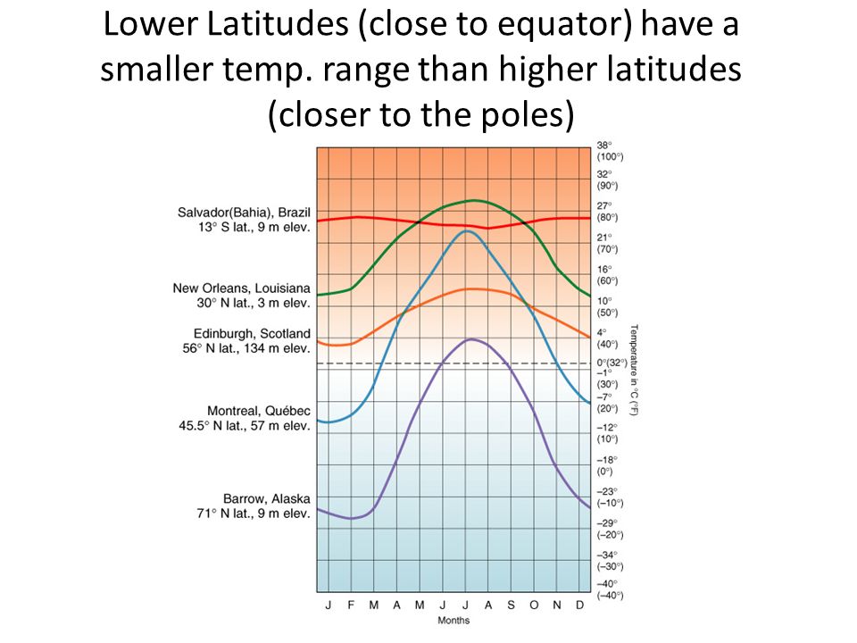
Lower Latitudes (close to equator) have a smaller temp. range than higher latitudes (closer to the poles)
.")
30
2) Altitude (elevation) Temperature decreases as altitude increases, due to a drop in pressure. – Expansional Cooling. High mountains might have tropical vegetation at the base, but, permanent ice and snow at the peaks.

31
Mountains 3) Orographic Effect – Mountains block prevailing winds which forces air to rise on one side and sink on the other. – Windward side – cool and wet – Leeward side – warm and dry

32
Prevailing Winds mountain Moist air rises expands Condenses Dry air Sinks compresses warms cools Chinook winds

33
The side of the mountain where the moist prevailing winds are coming from is called the __________________ Summary: Wind Windward side moist air rises expands cools condenses windward Windward Side of Mountain

34
The side of the mountain where the air descends is called the ______________________ Summary: Leeward side dry air sinks compresses warms leeward Wind Leeward Side of Mountain

35
Orographic Lifting 13

36
4) Large Bodies of Water Large bodies of water moderate the temperature of nearby land. – Areas near water have a lower temperature range throughout the year (and are normally wetter). – Inland areas are warmer in summer and cooler in winter.
. – Inland areas are warmer in summer and cooler in winter..")
37
Marine and Continental Climates

38
Planetary Wind Belts Prevailing winds may determine whether air masses arrive from a hot region or from a cold region. – Planetary winds are driven by unequal heating of the Earth ’ s surface. Creates pressure belts Example: equator is wet (low pressure) and at 30°N or 30°S dry (high pressure)
 and at 30°N or 30°S dry (high pressure).")
40
Climate Anomalies a·nom·a·ly – an odd, peculiar, or strange condition/situation – Example: “El Nino, La Nina, and Global Warming are all examples of global climate anomalies.”

41
Global Climate Anomalies El Niño and La Niña – a disruption of the ocean-atmosphere system in the Tropical Pacific El Nino-higher than normal ocean temp. at the equatorial Pacific La Nina-colder than normal ocean temp. at equatorial Pacific These two phenomena have profound effects on the U.S. weather and on hurricane development in Atlantic.

42
Normal Pattern Focus Study 10.1 - Figure 1

43
El Niño Focus Study 10.1 - Figure 1

44
Normal pattern El Nino

Similar presentations


>")


 Small geographic area Can change rapidly.>")


 The average temperature over the year 2) The annual temperature range (difference between the.>")