Download presentation
Presentation is loading. Please wait.

1
Heating the Atmosphere and Temperature Controls Where the heat comes from and how it gets distributed…

2
Heating the Atmosphere 99.9% of the earth’s energy comes from the sun Energy from the sun is not evenly distributed over the earth due to earth’s tilt and motions Day/night insolation differences are obvious! Tilt makes lower latitudes (equator) receive more direct solar energy (called insolation)
 receive more direct solar energy (called insolation).")
3
Heating the Atmosphere Higher latitudes (poles) receive less direct insolation overall Higher latitudes (poles) receive less direct insolation overall Additionally, seasons are caused by the tilt of the earth Seasons are NOT caused by earth-sun distance changing!!!! Seasons are NOT caused by earth-sun distance changing!!!! Changes the amount of insolation at the poles dramatically, but doesn’t really affect the equator Changes the amount of insolation at the poles dramatically, but doesn’t really affect the equator

4
Characteristics of the Seasons (Northern Hemisphere) SpringSummerAutumnWinter Mar 21 June 21 Sept 21 Dec 21 Sun at equator Sun at Tropic of Cancer (23.5° N) Sun at equator Sun at Tropic of Capricorn (23.5° S) Days & nights equal Longest Daylight Days & nights equal Shortest Daylight All regions on earth experience equal daylight Further north experiences longer daylight All regions on earth experience equal daylight Further south experiences longer daylight
 SpringSummerAutumnWinter Mar 21 June 21 Sept 21 Dec 21 Sun at equator Sun at Tropic of Cancer (23.5° N) Sun at equator Sun at Tropic of Capricorn (23.5° S) Days & nights equal Longest Daylight Days & nights equal Shortest Daylight All regions on earth experience equal daylight Further north experiences longer daylight All regions on earth experience equal daylight Further south experiences longer daylight")
5
The Seasons and Daylight

6
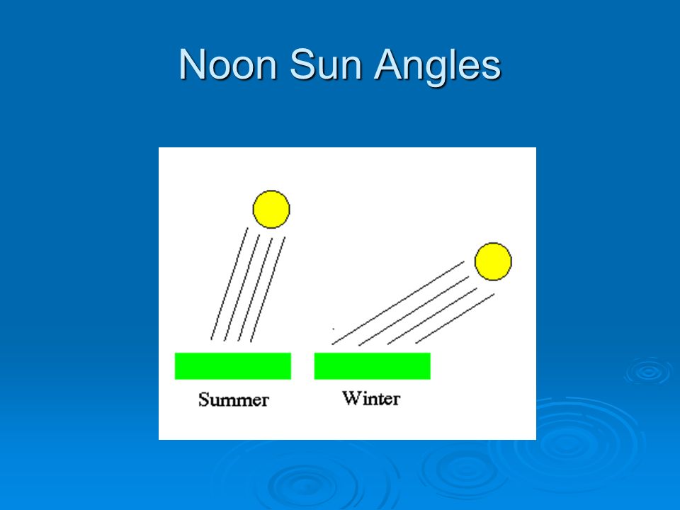
Noon Sun Angles The degree to which an area will be directly heated by the sun is a factor of how high the sun is at noon This is determined by the latitude of the location and the position of the sun on the particular date This is determined by the latitude of the location and the position of the sun on the particular date

7
Noon Sun Angles For example – on June 21, the sun is directly overhead (90°) at a latitude of 23.5° N (Tropic of Cancer). What angle will we experience on that day?

8
Noon Sun Angles To find the angle the sun makes on a given date, first you must know the latitude of the location. NJ is at 40° N latitude NJ is at 40° N latitude You then determine the difference between that latitude and the sun’s position The sun was at 23.5° N on that date The sun was at 23.5° N on that date So…40 – 23.5 = 16.5° So…40 – 23.5 = 16.5° The noon sun angle is 90 minus this value 90° - 16.5° = 73.5° 90° - 16.5° = 73.5° This is the highest the sun ever gets in NJ!!! This is the highest the sun ever gets in NJ!!!

9
Noon Sun Angles Let’s try another one! What’s the noon sun angle in NJ on the first day of winter (12/21)? What’s the noon sun angle in NJ on the first day of winter (12/21)? On 12/21, the sun is located at 23.5° S latitude (remember south is negative!) On 12/21, the sun is located at 23.5° S latitude (remember south is negative!) So…40-(-23.5) = 40+23.5 = 63.5 So…40-(-23.5) = 40+23.5 = 63.5 90-63.5 = 26.5° 90-63.5 = 26.5° This is the lowest the sun ever gets in NJ! This is the lowest the sun ever gets in NJ! Question – does this make sense in terms of temperature???
. What’s the noon sun angle in NJ on the first day of winter (12/21). On 12/21, the sun is located at 23.5° S latitude (remember south is negative!) On 12/21, the sun is located at 23.5° S latitude (remember south is negative!) So…40-(-23.5) = = 63.5 So…40-(-23.5) = = = 26.5° = 26.5° This is the lowest the sun ever gets in NJ. This is the lowest the sun ever gets in NJ. Question – does this make sense in terms of temperature .")
10
Noon Sun Angles One more together – What is the noon sun angle in NJ on the first day of spring (3/20)? What is the noon sun angle in NJ on the first day of spring (3/20)? On 3/20, the sun is at the equator (0°). On 3/20, the sun is at the equator (0°). 40-0 = 40 and 90-40 = 50° 40-0 = 40 and 90-40 = 50° On your own – what is the noon sun angle today (sun is at 16° N)?
. On 3/20, the sun is at the equator (0°). On 3/20, the sun is at the equator (0°) = 40 and = 50° 40-0 = 40 and = 50° On your own – what is the noon sun angle today (sun is at 16° N) .")
11
Why is the Noon Sun Angle Important? The angle of the sun indicates how directly heated an area will be Direct rays (90°) will be more “concentrated” and will pass through less atmosphere Indirect rays (not 90°) will pass through a thicker layer of atmosphere and will become more “spread out”
 will be more concentrated and will pass through less atmosphere Indirect rays (not 90°) will pass through a thicker layer of atmosphere and will become more spread out .")
12
Noon Sun Angles

14
What Happens to Incoming Insolation? 50% of the incoming insolation is absorbed by land and sea 20% is absorbed by atmosphere and clouds Remaining 30% is reflected back to space Contrary to popular belief, the sun does not directly warm the air – the sun warms the earth and the earth warms the air above it! Air heats from the ground up!!! Air heats from the ground up!!!

15
What Happens to Incoming Insolation?

16
Heat Balance Areas in equatorial regions have a heat surplus – receive more energy than they emit Areas in polar regions have a heat deficit – emit more energy than they receive Two areas balance out overall to create a true heat balance

17
Controls of Temperature Latitude Differential Heating of Land and Sea Altitude Ocean Currents Geographic Position Cloud Cover and Albedo

18
Latitude Latitude is the most obvious control of temperature Equatorial regions receive more insolation and therefore are hotter than polar regions Additionally, equatorial regions experience constant heating throughout the year and so have little temperature variations Polar regions experience a intense heating in the summer and very little heating in the winter, creating greater extremes in temperature Polar regions experience a intense heating in the summer and very little heating in the winter, creating greater extremes in temperature

19
Temperature Variations by Latitude

20
Differential Heating of Land and Water Land and water have different heat capacities (heat up and cool down at different rates) Water heats up and cools down slower than land Water heats up and cools down slower than land Water will retain its temperature than land Water will retain its temperature than land
 Water heats up and cools down slower than land Water heats up and cools down slower than land Water will retain its temperature than land Water will retain its temperature than land")
21
Differential Heating of Land and Water Differences are very apparent when comparing the hemispheres due to the greater amount of water in the SH 45 N latitude (NJ) experiences about a 23 temperature difference between winter and summer 45 N latitude (NJ) experiences about a 23 temperature difference between winter and summer 45 S latitude (Melbourne, Australia) experiences about a 6 degree difference between winter and summer 45 S latitude (Melbourne, Australia) experiences about a 6 degree difference between winter and summer
 experiences about a 23 temperature difference between winter and summer 45 N latitude (NJ) experiences about a 23 temperature difference between winter and summer 45 S latitude (Melbourne, Australia) experiences about a 6 degree difference between winter and summer 45 S latitude (Melbourne, Australia) experiences about a 6 degree difference between winter and summer")
22
Temperature Variations by Latitude

23
Differential Heating of Land and Water Differences can also be easily seen when comparing two cities of equal latitude where one is adjacent to an ocean and the other is not Called “continentality” Called “continentality” For example, Vancouver is along the ocean and so it does not experience the great temperature extremes that Winnipeg does

24
Continentality

25
Altitude Altitude is the most dramatic control of temperature (as previously discussed) The environmental lapse rate (ELR) is 6.5°C/km Every km rise in height creates a drop in temperature of 6.5°C (13°F) Every km rise in height creates a drop in temperature of 6.5°C (13°F) For example – Quito and Guayaquil Guayaquil is at sea level and Quito is high in the Andes Guayaquil is at sea level and Quito is high in the Andes Even though Quito is closer to the equator, it is much colder due to its high elevation Even though Quito is closer to the equator, it is much colder due to its high elevation
 The environmental lapse rate (ELR) is 6.5°C/km Every km rise in height creates a drop in temperature of 6.5°C (13°F) Every km rise in height creates a drop in temperature of 6.5°C (13°F) For example – Quito and Guayaquil Guayaquil is at sea level and Quito is high in the Andes Guayaquil is at sea level and Quito is high in the Andes Even though Quito is closer to the equator, it is much colder due to its high elevation Even though Quito is closer to the equator, it is much colder due to its high elevation")
26
Altitude

27
Ocean Currents Surface ocean currents also affect temperatures Some ocean currents are warm and others are cold Warm currents flow from the equator to the poles along the eastern side of a continent Cold currents flow from the poles to the equator along the western side

28
Ocean Currents

29
Being adjacent to a cold water current will lower temperatures For example – Arica, Chile and Rio de Janeiro are both at nearly the same latitude and elevation and both are coastal For example – Arica, Chile and Rio de Janeiro are both at nearly the same latitude and elevation and both are coastal But Arica is adjacent to the cold Peru current and Rio de Janeiro is near the warm Brazil current But Arica is adjacent to the cold Peru current and Rio de Janeiro is near the warm Brazil current So, Arica is cooler than Rio de Janeiro as a result So, Arica is cooler than Rio de Janeiro as a result

30
Ocean Currents

31
Geographic Position Geographic position can refer to the wind patterns or to mountain ranges or even large lakes For example, in the USA, the prevailing winds blow from the west For example, in the USA, the prevailing winds blow from the west Areas along the west (windward) coast will be less extreme since the winds travel across the ocean to them Areas along the west (windward) coast will be less extreme since the winds travel across the ocean to them Areas along the east (leeward) coast will be more extreme since the winds blow across the continent Areas along the east (leeward) coast will be more extreme since the winds blow across the continent However, if the winds blew the opposite (east to west) the reverse would be true However, if the winds blew the opposite (east to west) the reverse would be true
 coast will be less extreme since the winds travel across the ocean to them Areas along the west (windward) coast will be less extreme since the winds travel across the ocean to them Areas along the east (leeward) coast will be more extreme since the winds blow across the continent Areas along the east (leeward) coast will be more extreme since the winds blow across the continent However, if the winds blew the opposite (east to west) the reverse would be true However, if the winds blew the opposite (east to west) the reverse would be true")
32
Geographic Position

33
Mountain ranges also affect temperature Regions on the leeward (behind) side of a mountain range often experience dramatic swings in temperature Regions on the leeward (behind) side of a mountain range often experience dramatic swings in temperature Loma, MT experienced a change of over 100°F (from -56 to +49) in 24 hours! Loma, MT experienced a change of over 100°F (from -56 to +49) in 24 hours!
 in 24 hours!.")
34
Cloud Cover and Albedo Clouds serve to moderate temperatures Make it cooler during the day and warmer at night Make it cooler during the day and warmer at night Areas with greater cloud cover will experience less temperature shifts Areas with greater cloud cover will experience less temperature shifts Albedo refers to the reflectivity of certain surfaces – more reflective, cooler temperatures

35
Cloud Cover and Albedo

Similar presentations