Download presentation
Presentation is loading. Please wait.

2
Fraser Island Area = 1,840 km 2 (710 sq mi) Highest Elevation = 244 m (801 ft) Bribie Island Area =148 km 2 (57.1 sq mi) 1/12 Fraser’s area
 Highest Elevation = 244 m (801 ft) Bribie Island Area =148 km 2 (57.1 sq mi) 1/12 Fraser’s area")
3
Bribie Island and Fraser Island are very different in scale & topography But they share a number of features: They are both composed of fine siliceous sand. Much of the sand in both islands once filled what are now the great gorges and valleys of the Blue Mountains in New South Wales

4
Bribie Island and Fraser Island are very different in scale & topography But they share a number of features: They are both composed of fine siliceous sand. The source of the sand for both has been moved north by littoral transportation.

5
BRIBIE ISLAND

6
Bribie Island and Fraser Island are very different in scale & topography But they share a number of features: They are both composed of fine siliceous sand. The source of the sand for both has been moved north by littoral transportation. The deposition of the sand in both places has been by aeolian forces (wind).
..")
8
Bribie Island and Fraser Island are very different in scale & topography But they share a number of features: They are both composed of fine siliceous sand. The source of the sand for both has been moved north by littoral transportation. The deposition of the sand in both places has been by aeolian forces (wind). Almost immediately that these forces accumulated the sand in the form of dunes the dunes were vegetated and stabilized.
. Almost immediately that these forces accumulated the sand in the form of dunes the dunes were vegetated and stabilized..")
10
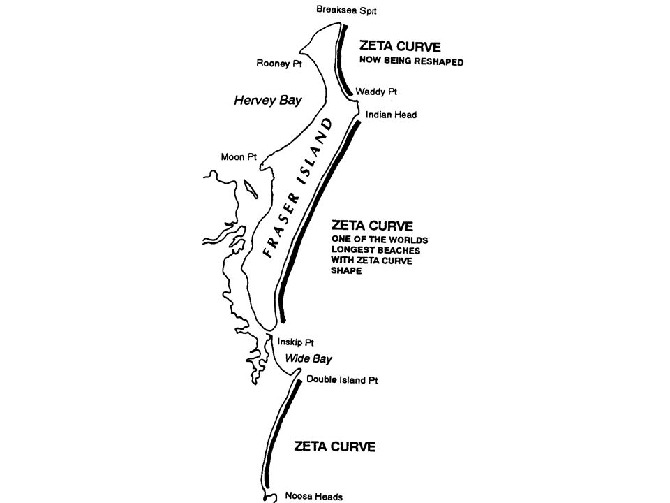
Bribie Island and Fraser Island are very different in scale & topography But they share a number of features: They are both composed of fine siliceous sand. The source of the sand for both has been moved north by littoral transportation. The deposition of the sand in both places has been by aeolian forces (wind). Almost immediately that these forces accumulated the sand in the form of dunes the dunes were vegetated and stabilized. Both are based on dunes that are highly erodible by both the forces of wind and water. That erodibility is demonstrated by the shape of the coastlines that are determined by the direction and strength of prevailing winds and the apexes of the Zeta curves
. Almost immediately that these forces accumulated the sand in the form of dunes the dunes were vegetated and stabilized. Both are based on dunes that are highly erodible by both the forces of wind and water. That erodibility is demonstrated by the shape of the coastlines that are determined by the direction and strength of prevailing winds and the apexes of the Zeta curves.")
12
There are significant differences in the dunes that have evolved on Fraser Island and Bribie Island:

13
Fraser Island the dunes have are much older. The oldest dunes on Fraser Island are estimated to be at least 800,000 years old whereas the dunes of Bribie Island are estimated at only 5,500 to 6,000 years.

14
There are significant differences in the dunes that have evolved on Fraser Island and Bribie Island: Fraser Island the dunes have are much older. The oldest dunes on Fraser Island are estimated to be at least 800,000 years old whereas the dunes of Bribie Island are estimated at only 5,500 to 6,000 years. CSIRO researcher into the coastal lowlands of South East Queensland and northern New South Wales, Coaldrake applied the term “Bribie” to systems of low lying parallel dunes. This system covers almost the whole of Bribie Island, whereas it constitutes on a small part of Fraser Island, mainly in the south east near North Spit and at the western extremity near Moon Point.

15
Bribie Island’s classical parallel dunes stretch across most of the northern part of the island. Although there are parallel dunes in the south they aren’t in the same alignment as these dunes.

16
There are significant differences in the dunes that have evolved on Fraser Island and Bribie Island: Fraser Island the dunes have are much older. The oldest dunes on Fraser Island are estimated to be at least 800,000 years old whereas the dunes of Bribie Island are estimated at only 5,500 to 6,000 years. CSIRO researcher into the coastal lowlands of South East Queensland and northern New South Wales, Coaldrake applied the term “Bribie” to low lying parallel dunes system. This system covers the whole of Bribie Island, whereas it constitutes on a small part of Fraser Island, mainly in the south east near North Spit and at the western extremity near Moon Point. The bulk of Fraser Island was built up by a series of depositions that usually accompanied rising sea levels over the eons. There have been at least six episodes of invasion and each of the new invasions of sand has resulted in transvers dunes so that instead of being parallel to the beach as they are on Bribie Island, most of Fraser Island dunes have been aligned by the prevailing wind from the south east to the north west.

17
Fraser Island has only two small sections of parallel (Bribie) dunes, in the South east and most western (Moon Point) areas. Most of the dunes are high dunes running in the direction of the prevailing winds rather than parallel to the beach

18
The parallel dunes of the Bribie dune system were created as a result of a slight fall in sea level. About 10,000 years ago there was a great ice age and the sea level was about the lowest that scientists can discover in geological history. The sea level has been estimated to have been 120 metres below what it is now. The coastline would have been several kilometres east of Cape Moreton. The low lying land between what is now Bribie Island and the coast there would have included deep ravines and river valleys draining the D’Aguilar and Blackall Ranges. The ancestral Brisbane River probably flowed out past Cape Moreton.

19
All of the Australian continental shelf shown on this map would have been part of the Australian mainland only 10,000 years ago. Fraser Island and Bribie Island would have been part of the mainland and Great Sandy Strait, Hervey Bay and Pumicestone Passage and Moreton Bay would have been dry land.

20
Between 10,000 B.P. and 6,000 B.P. the sea level rose an estimated 120 metres. (About the same rate as the currently estimated sea level rise) Higher sea levels slowed the velocity of those rivers and the sediments being carried in those slowing stream were deposited filling the valleys and catchment areas. What is now Moreton Bay filled with sediment from the Brisbane Pine and Logan Rivers as the sea slowly moved into this once deep valley.
 Higher sea levels slowed the velocity of those rivers and the sediments being carried in those slowing stream were deposited filling the valleys and catchment areas. What is now Moreton Bay filled with sediment from the Brisbane Pine and Logan Rivers as the sea slowly moved into this once deep valley..")
21
The sea rose to its highest level (approx a metre higher than at present) about 6,000 B.P. when a mini-ice age set in. Over the next 500 years the sea level dropped by just one metre and it has remained relatively constant since until the last century. The one metre sea level change added about 5% to the area of Fraser Island and but it was responsible for creating 100% of the area of Bribie Island.

22
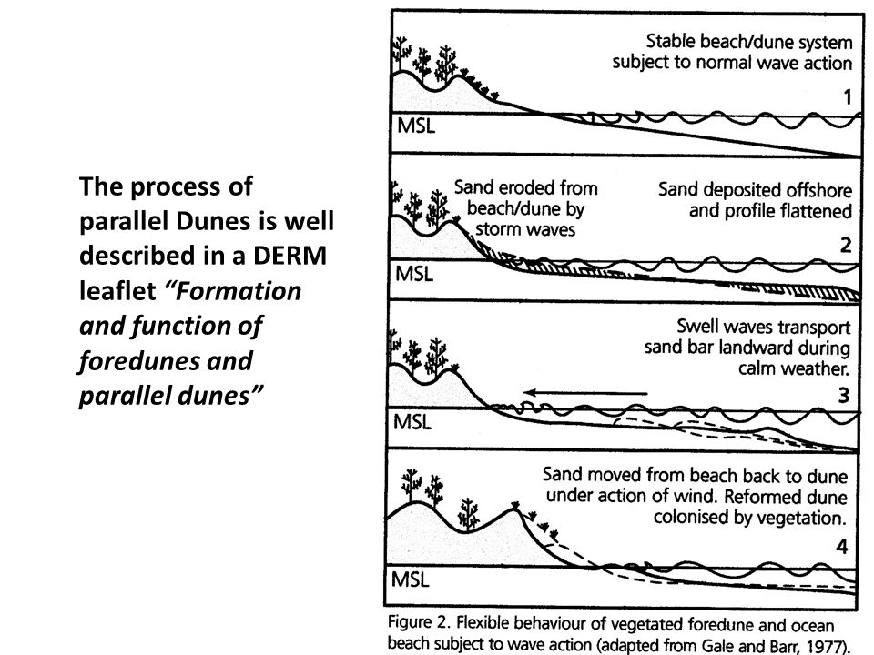
The process of parallel Dunes is well described in a DERM leaflet “Formation and function of foredunes and parallel dunes”

24
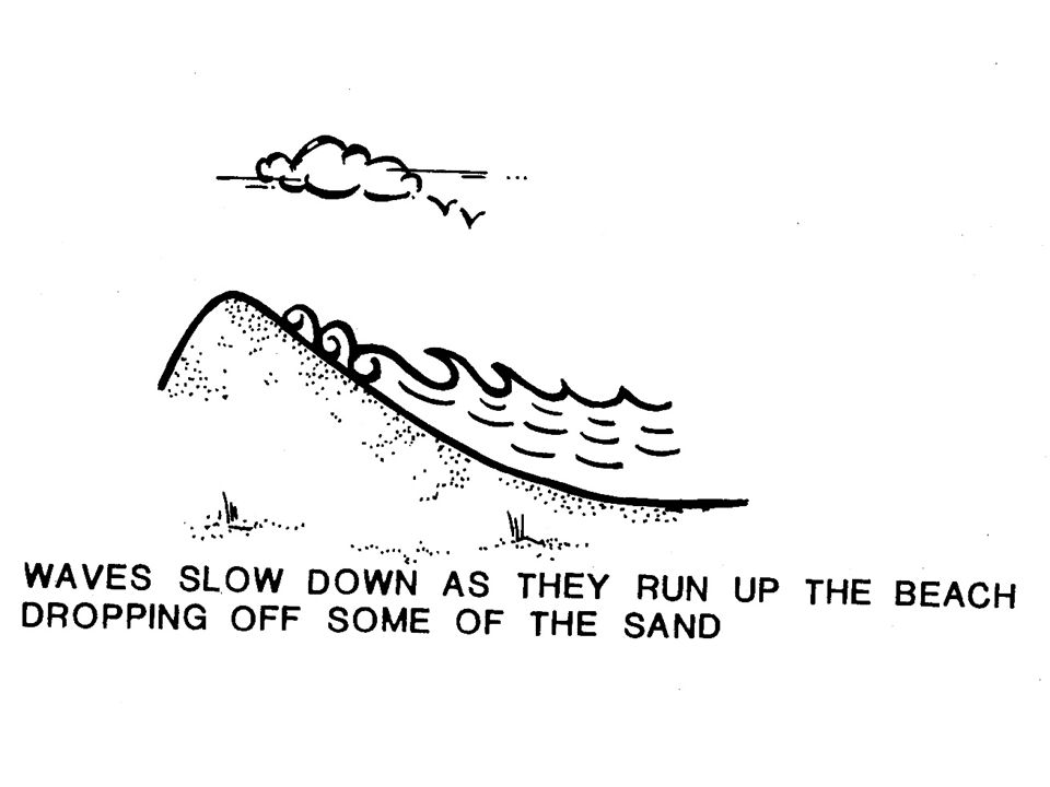
As well as the problems of wind and waves attacking the dunes at the front, it needs to be notes that all the time raindrops are slowly leveling out the dunes and sand grains bounce down the slopes slowly filling the swales.

25
Bribie’s parallel dunes don’t all run in the same direction

26
Five reasons for protecting Bribie’s dunes: 1.Bribie has clean ocean beaches that are in great demand in this sub- tropical environment.

27
Bribie dunes need to be protected: 1.Bribie has clean ocean beaches that are in great demand in this sub-tropical environment. 2.Bribie is surrounded by the fastest growing urban hub in Australia increasing the demand for access to the Bribie beaches.

28
Five reasons for protecting Bribie’s dunes: 1.Bribie has clean ocean beaches that are in great demand in this sub- tropical environment. 2.Bribie is surrounded by the fastest growing urban hub in Australia increasing the demand for access to the Bribie beaches. 3.Bribie is more accessible and affordable to reach than either Stradbroke Island or Moreton Island.

29
Five reasons for protecting Bribie’s dunes: 1.Bribie has clean ocean beaches that are in great demand in this sub- tropical environment. 2.Bribie is surrounded by the fastest growing urban hub in Australia increasing the demand for access to the Bribie beaches. 3.Bribie is more accessible and affordable to reach than either Stradbroke Island or Moreton Island; 4. The bulk of Bribie Island is still in a relatively natural state. It hasn’t been mined and there is a significant National Park; and

30
Five reasons for protecting Bribie’s dunes: 1.Bribie has clean ocean beaches that are in great demand in this sub- tropical environment. 2.Bribie is surrounded by the fastest growing urban hub in Australia increasing the demand for access to the Bribie beaches. 3.Bribie is more accessible and affordable to reach than either Stradbroke Island or Moreton Island; 4. The bulk of Bribie Island is still in a relatively natural state. It hasn’t been mined and there is a significant National Park; and 5.Having the nearest accessible clean beach to Brisbane and “natural” appeal, the demand for recreation on Bribie Island is already strong.

31
The future Bribie Island already provides a natural beach recreation experience to large numbers of visitors. It provides some of the elements of the experiences that many people go as far as to Fraser Island to seek.

32
The future Bribie Island already provides a natural beach recreation experience to large numbers of visitors. It provides some of the elements of the experiences that many people go as far as to Fraser Island to seek. As the price of energy rises more people will be seeking this experiences ever closer to home and the demand for recreation on Bribie will escalate faster than population growth.

33
The future Bribie Island already provides a natural beach recreation experience to large numbers of visitors. It provides some of the elements of the experiences that many people go as far as to Fraser Island to seek. As the price of energy rises more people will be seeking this experiences ever closer to home and the demand for recreation on Bribie will escalate faster than population growth. Bribie Island though is very vulnerable to erosion and subject to sea level changes at least as much as any of the small Pacific Island nations or the Great Barrier Reef.

34
The future Bribie Island already provides a natural beach recreation experience to large numbers of visitors. It provides some of the elements of the experiences that many people go as far as to Fraser Island to seek. As the price of energy rises more people will be seeking this experiences ever closer to home and the demand for recreation on Bribie will escalate faster than population growth. Bribie Island though is very vulnerable to erosion and subject to sea level changes at least as much as any of the small Pacific Island nations or the Great Barrier Reef. The foredune fencing project though shows that the same forces of nature that are capable of stripping away Bribie Island’s precious sand are also capable of being harnessed to redeposit that sand where it is needed.

Similar presentations


 1. How does a wave form? 2. How do waves change near the shore? 3. How do waves affect.>")


