Download presentation
Presentation is loading. Please wait.

1
NOPS 2016 PS Weather Operations

2
ROMAN is GONE! Some workable replacements: MesoWest NWS Plots WIMS DRI

3
Our Products: 7-Day Daily (2-Day) Smoke Outlook Monthly Outlook Seasonal Outlook Reduced Staffing = ALL Spots from NWS Annual Operating Plan In-House Videos: Daily Webcast Season Assessment PS Description
 Smoke Outlook Monthly Outlook Seasonal Outlook Reduced Staffing = ALL Spots from NWS Annual Operating Plan In-House Videos: Daily Webcast Season Assessment PS Description")
4
Preliminary Look at NOPS Fire Season 2016 Current Conditions Environmental Considerations Outlooks

5
% Normal Precip Since Start of Rain Year (since Oct 1, 2015) % Normal precip JAN-APR 2016
 % Normal precip JAN-APR 2016")
6
Average Temperature: Departure from Normal Since Oct 1 Average Temperature: Departure from Normal Since Jan 1

7
Drought Conditions have improved quite a bit across the North Ops region over the winter and early spring Central and Southern CA still have large areas of severe to excessive drought

8
April Precip % of Normal April Ave Temp Departure from Normal

9
May Precip % of Normal May Avg Temp - Departure from Normal

10
Snowpack peaked in late March at the end of several winter storms Snowpack has been shrinking since then in warmer than normal weather 101% 92% 75% % Normal for Mar 24

11
Snowpack measurements are taken at the highest elevations Below 6000 ft, where official measurements are not taken, below normal snowfall has been melting off rather quickly 45%/67% MAY 1, 2016 55%/68% 36%/46%

12
FUELS Soils and dead fuels are showing gradual drying throughout the region Live fuels at lower elevations are green but beginning to cure Green-up is beginning at mid-elevations, and soon to begin at higher elevations

15
Short term weather patterns important to fire development - e.g. lightning, strong N/Offshore winds, heatwaves – are not foreseeable more than about 5-8 days ahead, so they remain wildcards CONSIDERATIONS

16
Standing or downed bug kill/tree mortality rather bad in central/southern Sierra, but also present & growing in North OPS The wet winter has created an above normal fine fuel crop at lower elevations – will be important starting in late July or August, especially in foothill & NE areas MORE CONSIDERATIONS

17
Google the California Tree Mortality Task Force Website… Clearly shows the trouble areas statewide

18
May thru July CPC Outlooks: near to above normal precipitation (mainly May through Mid-June) and somewhat above normal temperatures This implies a slower start of fire season than recent years PRECIPTEMP
 and somewhat above normal temperatures This implies a slower start of fire season than recent years PRECIPTEMP")
19
El Niño (warmer than normal sea surface temps in equatorial Pacific) expected to fade to neutral by summer La Niña (cold equatorial water) forecast to develop by late summer La Niña’s typical rain pattern wet in Pacific NW with dry conditions in SOPS La Niña El Niño
 expected to fade to neutral by summer La Niña (cold equatorial water) forecast to develop by late summer La Niña’s typical rain pattern wet in Pacific NW with dry conditions in SOPS La Niña El Niño")
20
Climate Prediction Center Oct-Dec rainfall outlook reflects pattern typical of La Niña

21
There’s evidence going from El Niño to La Niña puts summertime low pressure trough along West Coast that would lead to: MID JULY FORECAST Fewer/shorter heat waves Cooler nights / higher overnight RH Stronger onshore flow Fuels exposed to extreme conditions fewer hours/day Stronger S to SW winds E of the Cascade/Sierra crest

22
O C - AUG 2015 O C – Past 30 Days Above normal sea surface temps (SSTs) Pac NW - Baja – HI have cooled, but means what for our summer lightning? That warm water helped 2015 tropical systems survive longer and affect HI & their decay moisture reach SoCal… reason for large number of 2015 NOps lightning days???

23
North Ops Region Initial 2016 Fire Season Assessment MAY through JUNE Near to above normal precipitation Slightly above normal temperatures Delayed/more normal start date of fire season expected

24
North Ops Region Initial 2016 Fire Season Assessment JULY Slightly above normal temperatures Areas of tree mortality may become larger Cured, heavy fine fuels in valleys/foothills will increase fire potential there Normal

25
North Ops Region Initial 2016 Fire Season Assessment JULY con’t Fire potential trending to above normal E of the Cascade/Sierra crest due to heavy annual grass crop May also see same trend in southern portion of GA Case could be made for below normal fire potential in mid/higher elevations with green conditions persisting Normal

26
North Ops Region Initial 2016 Fire Season Assessment AUGUST (into OCTOBER) Heavy load of cured fine fuels brings above normal fire potential to Sac Valley & foothills in addition to E of Cascade/ Sierra crest May see other pockets of elevated fire potential develop in rest of NOPS Normal
 Heavy load of cured fine fuels brings above normal fire potential to Sac Valley & foothills in addition to E of Cascade/ Sierra crest May see other pockets of elevated fire potential develop in rest of NOPS Normal")
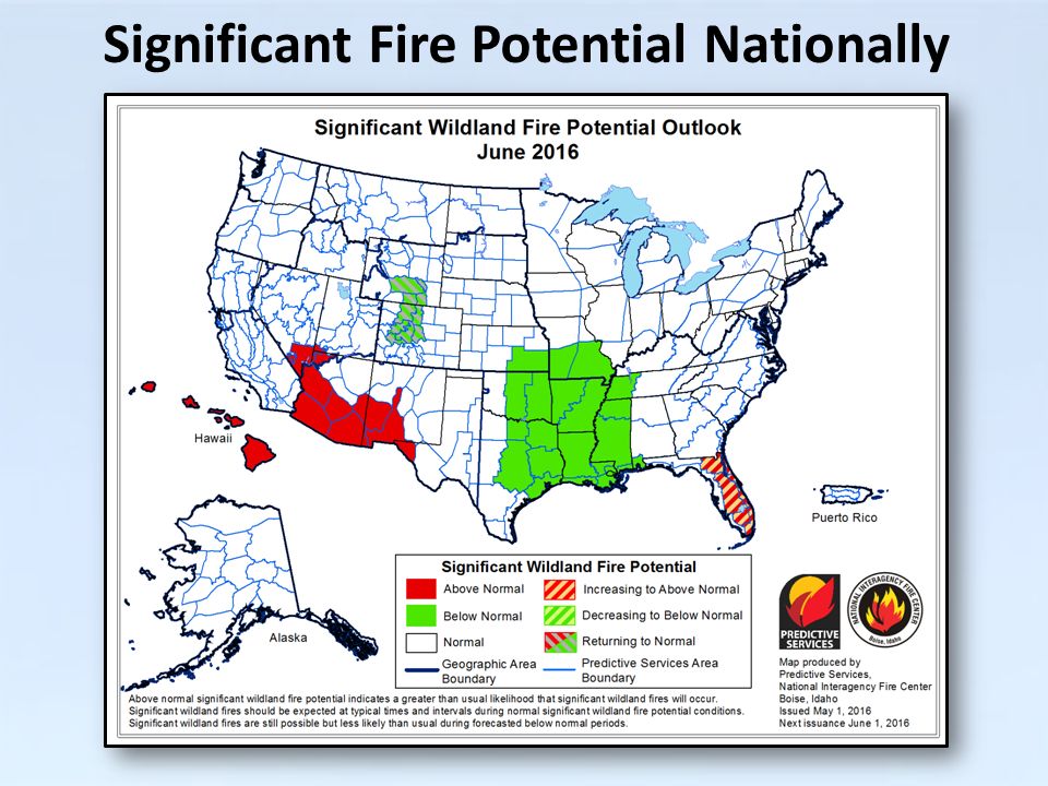
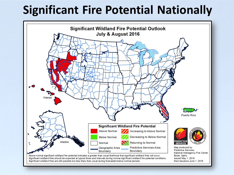
27
Significant Fire Potential Nationally

30
Any Questions?

31
% Normal precip JAN-APR 2016 HAWAI’I % Normal precip Just APR 2016 April temp departure from normal El Niño gives Hawai’i a dry, mild winter

32
HAWAI’I Drought increased over winter under El Niño influence DEC 1, 2015 MAY 3, 2016 Past Year of KBDI NORMAL

33
HAWAI’I Through JULY Drier/warmer than normal will continue KBDI will remain above normal/near critical values MAY – AUGUST 2016 AUGUST Much the same through early AUG Precipitation returning to seasonal normals, maybe above later in the month

34
HAWAI’I Sept – Oct Possibilities Above normal temperatures are likely to continue Precipitation expected to become normal or even above normal late summer and early fall Normal Fire Potential expected to return late this summer with Below Normal Fire Potential possible for early Fall

35
Any Questions?

Similar presentations


 is an index derived from North Pacific sea surface temperature anomalies and it has a high correlation to.>")


