Download presentation
Presentation is loading. Please wait.

1
3D GIS: TEACHING AND PLANNING FOR THE FUTURE John Marsden Department of Civic Design University of Liverpool

2
Department of Civic Design Town Planners Founded 1909 – World’s first university department of town and regional planning 1909 – 2000 postgraduate only (MCD) 2000 onwards 3 and 4 year undergraduate courses offered in addition to the MCD
 2000 onwards 3 and 4 year undergraduate courses offered in addition to the MCD")
3
Planners Planners are closely related to Geographers and Architects – we all use plans maps and models

4
Definition of Town Planning

5
Planning Town Planning Town and Regional Planning Town and Country Planning Land Use Planning City Planning Urban Planning and Environmental Management

6
Definition of Town Planning SPACE, PLACE and PEOPLE

7
History of Town Planning The Greek Hippodamus (c. 408 BC) is often considered the father of city planning in the West, for his design of Miletus, though examples of planned cities permeate antiquity. (http://en.wikipedia.org/wiki/Urban_planning# History)
 is often considered the father of city planning in the West, for his design of Miletus, though examples of planned cities permeate antiquity. ( History).")
8
History of Town Planning Image from The Town Planning Review Vol XXII (1951) by R E Wycherley (after von Gerkan, Griechisches Stadteanlagen, Taf. 6) Miletos (my-leet-us)
 Miletos (my-leet-us).")
9
Plans, Maps, and Models Ancient Port city of Miletos (Turkey) showing grid street plan
 showing grid street plan")
10
Miletus Ancient remains of Miletus Image from: http://www.turizm.net/cities/miletus/

11
Plans, Maps, and Models Michigan Avenue: Proposed new Boulevard C. H. Reilly, Town Planning in America (Professor of Architechure). From The Town Planning Review, Vol 1 No1 (1910)
. From The Town Planning Review, Vol 1 No1 (1910).")
12
TPR Town Planning Review Vol 1 No 1 (Just to prove I did the legwork)
")
13
Plans, Maps, and Models Map of car access in Liverpool created by first year students after 1 hour practical session using ArcMap This work is based on data provided through EDINA UKBORDERS with the support of the ESRC and JISC and uses boundary material which is copyright of the Crown

14
Plans, Maps, and Models 3D house created by first year students after 2 hour practical session with SketchUp

15
Demo 1: Building a 3D House Demo of building a 3D house using the free version of Google SketchUp (in 30 seconds)
")
16
Plans, Maps, and Models 2.5D image of soil samples taken on Caldy Hill, Merseyside created by 3 rd year students using ArcGIS and ArcScene

17
Demo 2: Build 2.5D model Insert here a demo of building a 2.5D GIS model of CaldyHill based on Ordnance Survey 1:10,000 Digital Terrain Model (DTM) Add survey points (60 seconds)
 Add survey points (60 seconds)")
18
First year students Stats, Maps’N’Pix Graphics in Microsoft Word SketchUp CorelPaint ArcView – ArcMap PowerPoint

19
Second year students Information Access and GIS ArcView: ArcMap,ArcCatalogue Urban Design SketchUp:

20
Third year students Geographical Information Systems: ArcView: ArcMap and ArcScene Making Places Further SketchUp

21
Demo 3: Student’s 3D Project Insert here a live SketchUp demo showing a completed 3 rd year project

22
Student 3D model (Dan Murphy)
")
23
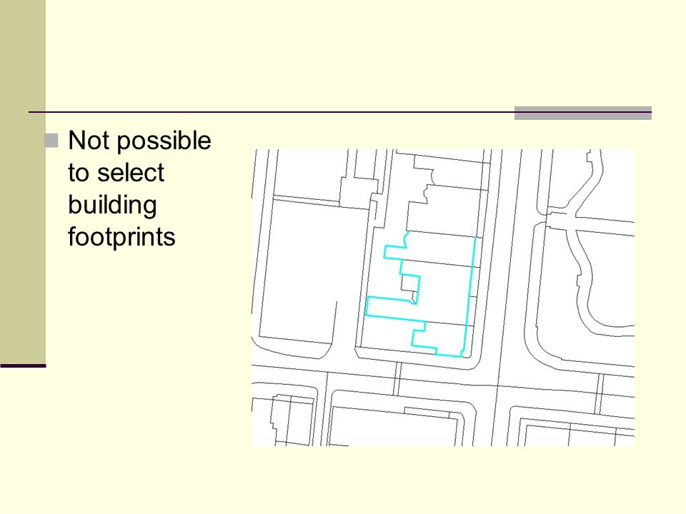
Problems with moving to 3D GIS Currently we use OS Land_Line Plus data from Digimap and available in convenient map tiles. Unfortunately there are advantages and disadvantages with map tiles, most notable disadvantage is the area you want never falls exactly on one tile.

24
For this project we are interested in Abercromby Square, the garden area in the centre of the image.

25
Unfortunately it falls between 4 map tiles

26
Demo 4 Switch to demo showing selection problems with Land_Line Plus data… Follow showing MasterMap solves this problem

27
Not possible to select building footprints

29
MasterMap: Hairy chunks TOIDs Building footprints

30
Converting the 2D image into a 3D GIS model Now possible with a new add-on from SketchUp

31
Demo 5 Open exported file in SketchUp to show how to quickly use photographs as rendering (60 seconds)
")
32
Extrude to height, in this case 6m

33
Paste on building side as photo

34
Paste on building frontage as photo, and… Export out as an ArcGIS.mdb file

35
Demo 6: Insert 3D Model to ArcScene Insert 3D models created in SketchUp into ArcScene (30 seconds)
")
36
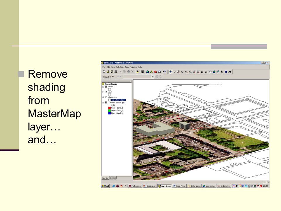
Open ArcScene Add in the OS MasterMap layer and….

37
Add in the 3D Model

38
Add in other models, perhaps worked on by another set of students…

39
Remove shading from MasterMap layer… and…

41
Demo 7 Close with examples of student models by Carolyn Tanner and Tom Edmunds

42
END

Similar presentations

![SEN In, Out and Beyond All About… All About... [insert company name]](/3/795130/big_thumb.jpg "SEN In, Out and Beyond All About… All About... [insert company name]>")


,>")

