Download presentation
Presentation is loading. Please wait.

1
WORLD GEO: DAY 2

2
Warm Up On a sheet of paper draw a map of where you have been today.

3
Warm Up Continued Now on that same sheet of paper draw a map of the world.

4
Was this difficult? Is your map perfectly accurate? Why? Why not?

5
Vocab Map Projection – a way of representing the spherical Earth on a flat surface Distortion – a change in the shape, size, or position of a place when it is shown on a map Absolute Location - the precise point where a place is located on earth Relative Location – where a place is located in relation to another place Latitude – Imaginary lines that run parallel around the earth and help measure degrees north and/or south of Equator Longitude – Imaginary lines that run from north poll to south and measure degrees east and west of the Prime Meridian

6
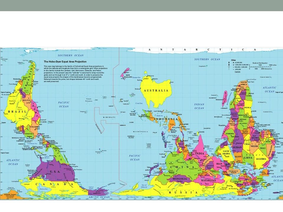
Which of the following is the most accurate map?

10
West Wing Video Clip https://www.youtube.com/watch?v=LA0BLrLW0PE

11
Map Buster https://www.youtube.com/watch?t=133&v=KUF_Ckv8HbE

12
Maps are cool! http://www.sacmeq.org/interactive- maps/statplanet/StatPlanet.html http://www.sacmeq.org/interactive- maps/statplanet/StatPlanet.html

13
What is this map depicting?

14
The only 22 countries exist that Great Britain has not invaded. Out of 196. Think: How is seeing this map different from just reading the statement above? How can maps affect the way we feel?

15
What do you think these countries have in common?

16
COFFEE COFFEE COFFEE

17
Surprised?

18
What is the most popular sport worldwide? What is the most popular in China?

20
I chose the wrong line of work.

21
What do you think this map represents?

22
Mapping an Event- The war in Afghanistan What is happening on this map? How do we begin to take graphics like this apart?

23
CARTOGRAM! I LOVE THESE THINGS! Who can figure this out?

24
More Vocab - Main types of maps: Political Map: show state and national boundaries and capital and major cities. A capital city is usually marked with a star within a circle. Physical Map: illustrate the physical features of an area, such as the mountains, rivers and lakes. The water is usually shown in blue. Different colors are used to show relief —differences in land elevations. Thematic Map: A thematic map is a type of map or chart especially designed to show a particular theme connected with a specific geographic area.

25
Pop Quiz! What type of map? Goat population of Texas.

29
Map Vocabulary! Map Scale: An element of a map that shows how a unit of distance on the map relates to actual distance. Map Legend or Key: a box or other display on a map that explains the meaning of the symbols used on the map. Compass Rose: A diagram on a map that shows directions

30
Seasons We have seasons because of the Earth’s tilt.

31
Exit Ticket: What type of map would I need… 1) To see where lakes, rivers, and seas are located in Asia? 2) To see the amount of Iphones in Kenya? 3) To see the boundaries between countries in North America?
 To see the amount of Iphones in Kenya. 3) To see the boundaries between countries in North America .")
32
Want to feel tiny? https://www.youtube.com/watch?v=HEheh1BH34Q

Similar presentations