Download presentation
Presentation is loading. Please wait.

1
CalNex Forecast Prepared Thursday 27 May 2010

2
Anticipated Platform Activities WP-3D Wednesday - Friday: No Fiights Saturday: anticipated evening-night flight, 7 pm takeoff Sunday: anticipated late night-early am flight, 10 PM takeoff NOAA Twin Otter: Next possible flight Friday CIRPAS Twin Otter: NASA King Air: R/V Atlantis: Tuesday nite: LA bight Wednesday: LA bight Thursday: LA bight Friday: Port of LA

3
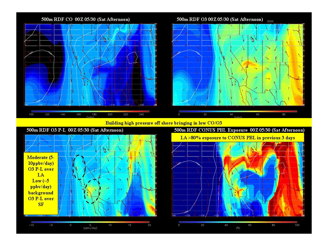
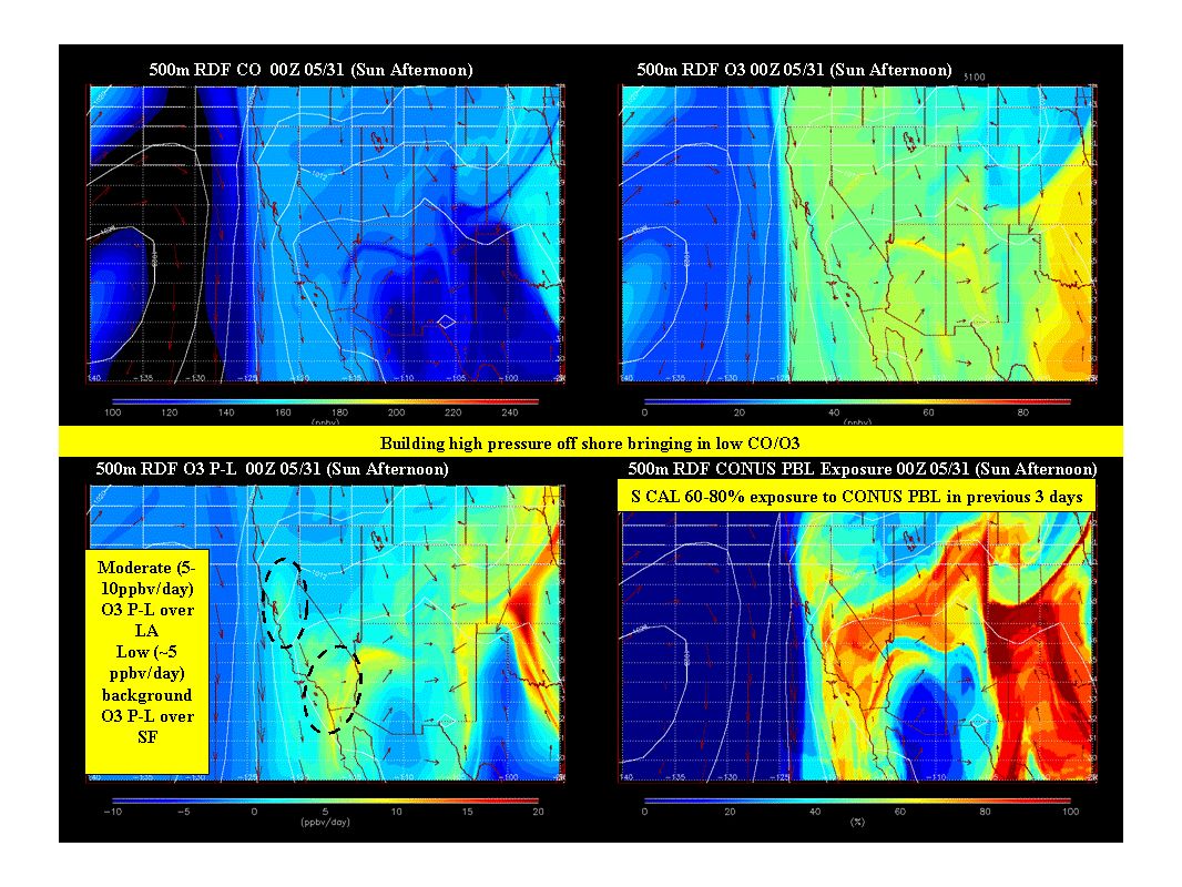
Local Features Friday: potential for NOAA Twin Otter to sample stratospheric intrusion and long range transport of polluted dusty air mass Saturday: morning offshore outflow from South Coast suggests planned P3 evening flight will be able to examine more seasonally representative recirculation. Sunday: Continued stagnation, higher concentrations and lighter flows compared to Saturday. Check next forecast cycle. Next week: Weak trough Monday, opportunities for somewhat higher concentrations Tues - Wed. GFS suggests weak trough affecting N CA beginning Thur-Fri.

4
Synoptic Overview for California Thursday May 27 Large upper low moves over Northern CA Showers/tstorms possible for Bay Area/Sac Valley Onshore surface flow both north and south Friday May 28 Upper low moves east into NV Transport flow turns N Gusty NW winds for SoCal mountains/deserts Saturday May 29 Offshore gradients develop for SoCal Upper ridge builds Sunday-Monday May 30-31 Upper ridge strengthens Transport flow weakens Weak trough brushes N CA on Mon Marine layer redevelops for coastal areas by Mon

5
Tuesday 17 PDT Analysis

6
Wednesday 17 PDT - Initialization Analysis

7
Thursday 05 PDT

8
Thursday 17 PDT

9
Friday 05 PDT

10
Friday 17 PDT

11
Saturday 05 PDT

12
Saturday 17 PDT

13
Sunday 05 PDT

14
Sunday 17 PDT

15
Monday 05 PDT - previous prediction

16
Monday 05 PDT - today's prediction

17
Tuesday 05 PDT

18
Wednesday 05 PDT

19
Thursday 05 PDT - previous forecast

20
Thursday 05 PDT - todays forecast

21
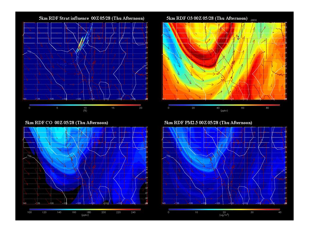
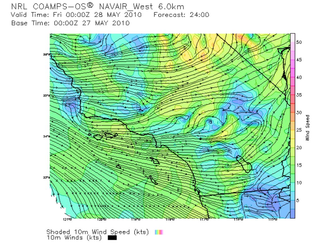
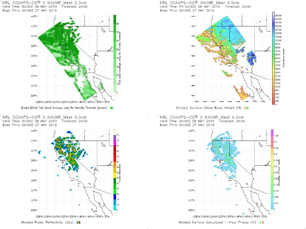
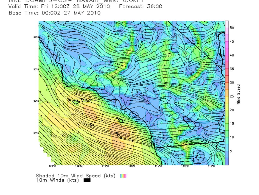
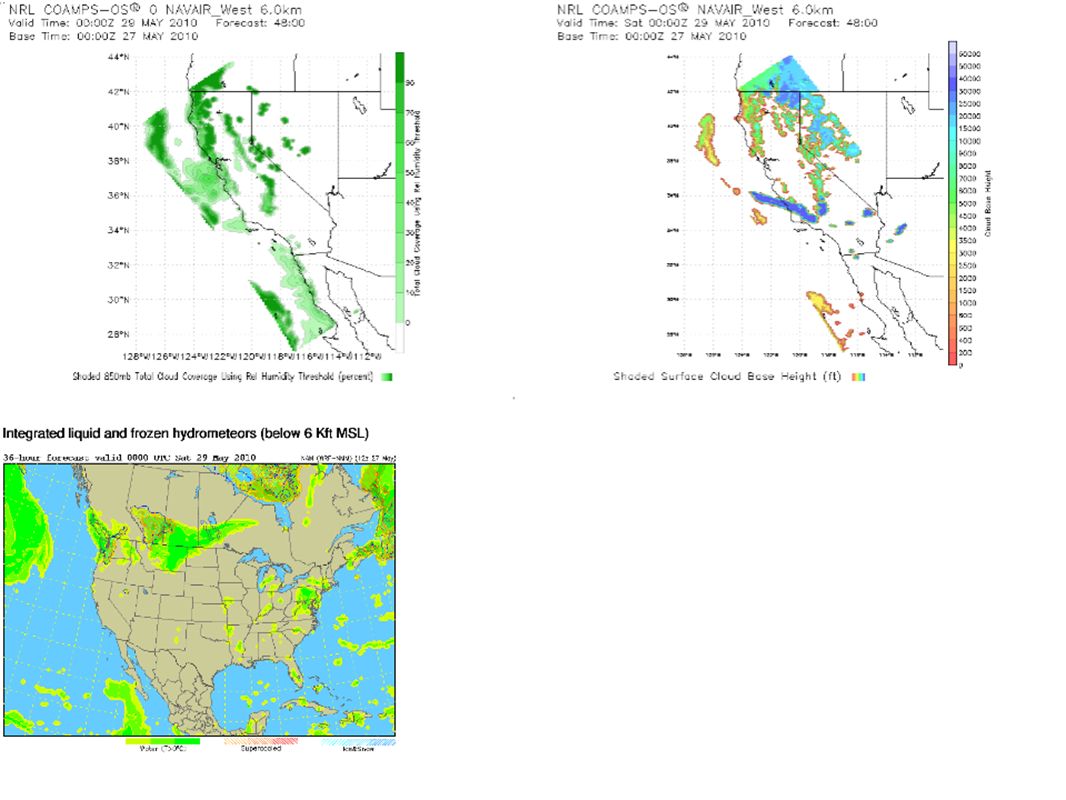
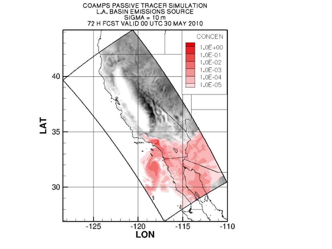
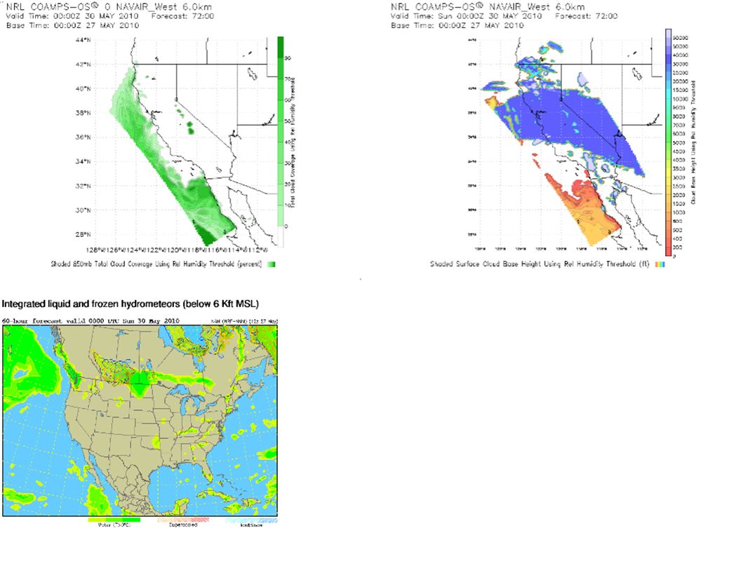
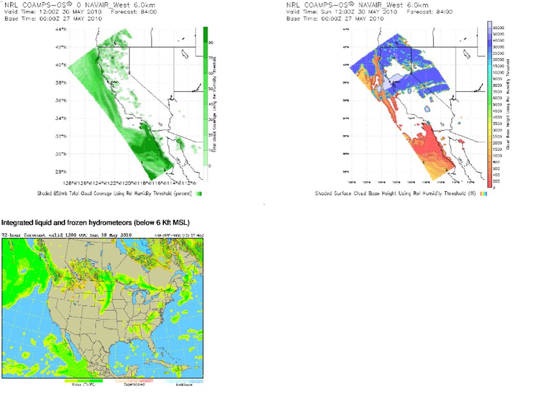
Large Scale Transport RAQMS FX updated Thu, May 27th

29
SF Bay Area Thursday SW 15kt turns W 5 to 10kt around mid morning; becomes NW late at night MBL 1,000 to 6,000 ft Friday NW wind strengthen into 15kt by late morning, max at 20 to 25 kt in the late afternoon and evening MBL 3,000 to 6,000 ft decreases throughout the day to 1,000 ft at 00Z Saturday NW 20kt continues and becomes 25kt in the afternoon, returns to 20kt at night MBL 500ft Sunday Same scenario as Saturday AM PBL 1,000ft Extended NW wind weakens on Monday, becomes westerly on Tuesday afternoon

30
Sacramento Valley Thursday Light and variable wind early AM; S and SE wind between 5 to 10kt; W 5 to 10kt in the early afternoon as trough passes; W 5kt wind in the evening AM PBL 1,000 to 5,000 ft; PM PBL 7,000 to 10,000ft Altostratus covering the area (becomes nimbostratus?); breaks into cumulonimbus scattered cumulus later in the day; 80% chance of rain Max aftn temp: 18C Good air quality: max 8-hr mean O3 in 0.04 ppm range Friday Light variable wind becoming northerly; NW 5kt by late morning through end of day Light AM downslope flow AM PBL 500 to 2,000 ft; PM PBL 3,000 to 5,000 ft Max aftn temp: 21C Altocumulus becomes mostly clear; 30% chance of precipitation Good air quality: max 8-hr mean O3 in 0.04 ppm range
; breaks into cumulonimbus scattered cumulus later in the day; 80% chance of rain Max aftn temp: 18C Good air quality: max 8-hr mean O3 in 0.04 ppm range Friday Light variable wind becoming northerly; NW 5kt by late morning through end of day Light AM downslope flow AM PBL 500 to 2,000 ft; PM PBL 3,000 to 5,000 ft Max aftn temp: 21C Altocumulus becomes mostly clear; 30% chance of precipitation Good air quality: max 8-hr mean O3 in 0.04 ppm range")
31
Sacramento Valley (cont'd) Saturday N to NW 5 to 10kt, strongest in the afternoon Max aftn temp: 26C AM PBL 1,000 ft; PM PBL 4,000 Thin, high cirrus, otherwise clear Good air quality: max-8hr mean O3 in 0.04 ppm range Sunday Light variable wind with downslope flow AM PBL 1,000ft Cirrus and cirrostratus expected Max aftn temp: 28C Good air quality: max-8hr mean O3 in 0.05 ppm range Extended Light variable wind, increasing onshore flow fom the delta with less downslope flow Mostly sunny except for cirrostratus Higher O3 conc, but still good air quality
 Saturday N to NW 5 to 10kt, strongest in the afternoon Max aftn temp: 26C AM PBL 1,000 ft; PM PBL 4,000 Thin, high cirrus, otherwise clear Good air quality: max-8hr mean O3 in 0.04 ppm range Sunday Light variable wind with downslope flow AM PBL 1,000ft Cirrus and cirrostratus expected Max aftn temp: 28C Good air quality: max-8hr mean O3 in 0.05 ppm range Extended Light variable wind, increasing onshore flow fom the delta with less downslope flow Mostly sunny except for cirrostratus Higher O3 conc, but still good air quality")
32
San Joaquin Valley Thursday May 27 Surface Winds: The surface observations this morning show calm to light and variable flow throughout most of the SJV, with a moderate N wind in the southern Valley. The wind profilers in the central Valley also show calm and variable conditions above the surface, with Tracy in the northern Valley showing a southerly flow, and Lost Hills in the southern Valley showing a northerly flow. CANSAC shows a flow into the northern SJV via the Delta and the Altamont Pass, with winds becoming light in the central and southern SJV as the day progresses. In the evening hours, CANSAC shows flow from SLO County into Kern County. GFS shows a chance for precipitation today. Boundary Layer Mixing: The wind profilers do not indicate temperature inversions this morning in the SJV. CANSAC indicates that mixing should improve to 5,500 feet throughout most portions of the SJV by the afternoon. Air Quality: Expected to be Good throughout the District due to good dispersion from the passing trough. Friday May 28 Surface Winds: CANSAC shows a moderate NW flow for the majority of the day throughout the SJV, and increasing as the day progresses. By the evening hours, CANSAC shows a strong outflow from the Valley portion of Kern County out into the Kern deserts over the Tehachapi Pass. Overnight flow over the mountainous terrain will be weak down slope due to the overall winds being from the W. Boundary Layer Mixing: CANSAC shows that mixing should improve to 4,000 feet across most of the SJV by the afternoon. Not as good as Thursday due to building stability. Air Quality: Good to Moderate air quality is expected across the SJV.

33
San Joaquin Valley Saturday May 29 Surface Winds: CANSAC shows lighter NW winds due to stabilizing conditions. NW flow in the northern SJV via the Delta and the Altamont Pass will increase as the day progresses. In the evening hours, outflow out of southern Valley into the Kern deserts is expected via Tehachapi and Tejon Passes. As the evening progresses, flow will tend toward offshore, and as a result, air will exchange from Kern County into SLO County, and down sloping off of the Sierra Nevada Mountains will be enhanced. Boundary Layer Mixing: CANSAC shows mixing will improve to 3,500 feet in the northern SJV, and to 2,500 feet in the central and southern SJV. During the overnight hours, the surface based inversion will reform, causing the pollutants formed during the afternoon hours to decouple from the surface. Air Quality: Expected to be mostly Moderate throughout the SJV, with a chance for USG in the southern portion of the District. Residual ozone levels may remain at elevated terrain. Sunday May 30 and Monday May 31 Surface Winds: GFS shows surface winds to be predominately light and from the N to NW throughout the day. Boundary Layer Mixing: Mixing conditions should be similar to Saturday. Air Quality: Expected to be Moderate to USG. *Potential Targets for next Flight Day* For Saturday evening, the air exchanges between the southern SJV, SLO County, and the Kern desert may be of interest. Down sloping off of the Sierra Nevada into the Valley may be good to capture.

34
Central Coast Prepared 5/26/2010 – 1:30 pm PST Thursday 5/27: Trough deepening over CA, Cloudy – Chance precipitation. NW flow aloft. Friday: Trough over CA/NV, partly cloudy, NW flow aloft. Blowing dust in afternoon/Moderate AQ – Oceano Dunes/Nipomo Mesa, Sundowner winds possible in canyons Gaviota/Santa Barbara coast Saturday: Trough over UT, NNE flow aloft. Mostly clear. Offshore flow brings warming to coast, and transport of ozone/precursors to coast/ridgetops. Ozone increases. NE flow eastern San Luis Obispo County ridgetops/Temblor Range. Sunday: Zonal flow, short wave trough over CA. NE flow eastern San Luis Obispo County ridgetops/Temblor Range. 850 mb temps reach 18 deg C, temperature inversion strengthens. Ozone increases – deteriorating air quality interior valleys/ridgetops. Monday: Zonal flow, short wave trough over NV. NE flow eastern San Luis Obispo County ridgetops/Temblor Range. Marine layer returns, stratus late. 850 mb temps reach 19 deg C Tuesday 6/1- Friday 6/4: Ridge builds over Western US. Air quality deteriorates interior ridgetops/valleys – moderate AQ (ozone). 850 mb temps reach 21 deg C Long range (GFS) – Sat 6/5 – Mon 6/7: Ridge remains in place – dispersion remains poor. Air quality: Good air quality with the following exceptions - moderate air quality on Friday 5/28 due to blowing dust midday/ afternoons-Oceano Dunes/Nipomo Mesa, Moderate air quality interior ridgetops/valleys on Tuesday 6/1 to Friday 6/4 due to increasing ozone. Significant features: Blowing dust Oceano Dunes/Nipomo Mesa peaking midday/afternoons - Friday 5/28, Ozone increases along Temblor Range ridgetops Saturday 5/29, Sunday 5/30, Monday 5/31. Ridge strengthens Tuesday- Friday and air quality deteriorates Temblor Range ridgetops, Carrizo Plains, Eastern SLO County.
. 850 mb temps reach 21 deg C Long range (GFS) – Sat 6/5 – Mon 6/7: Ridge remains in place – dispersion remains poor. Air quality: Good air quality with the following exceptions - moderate air quality on Friday 5/28 due to blowing dust midday/ afternoons-Oceano Dunes/Nipomo Mesa, Moderate air quality interior ridgetops/valleys on Tuesday 6/1 to Friday 6/4 due to increasing ozone. Significant features: Blowing dust Oceano Dunes/Nipomo Mesa peaking midday/afternoons - Friday 5/28, Ozone increases along Temblor Range ridgetops Saturday 5/29, Sunday 5/30, Monday 5/31. Ridge strengthens Tuesday- Friday and air quality deteriorates Temblor Range ridgetops, Carrizo Plains, Eastern SLO County..")
35
Southern Coastal Waters

57
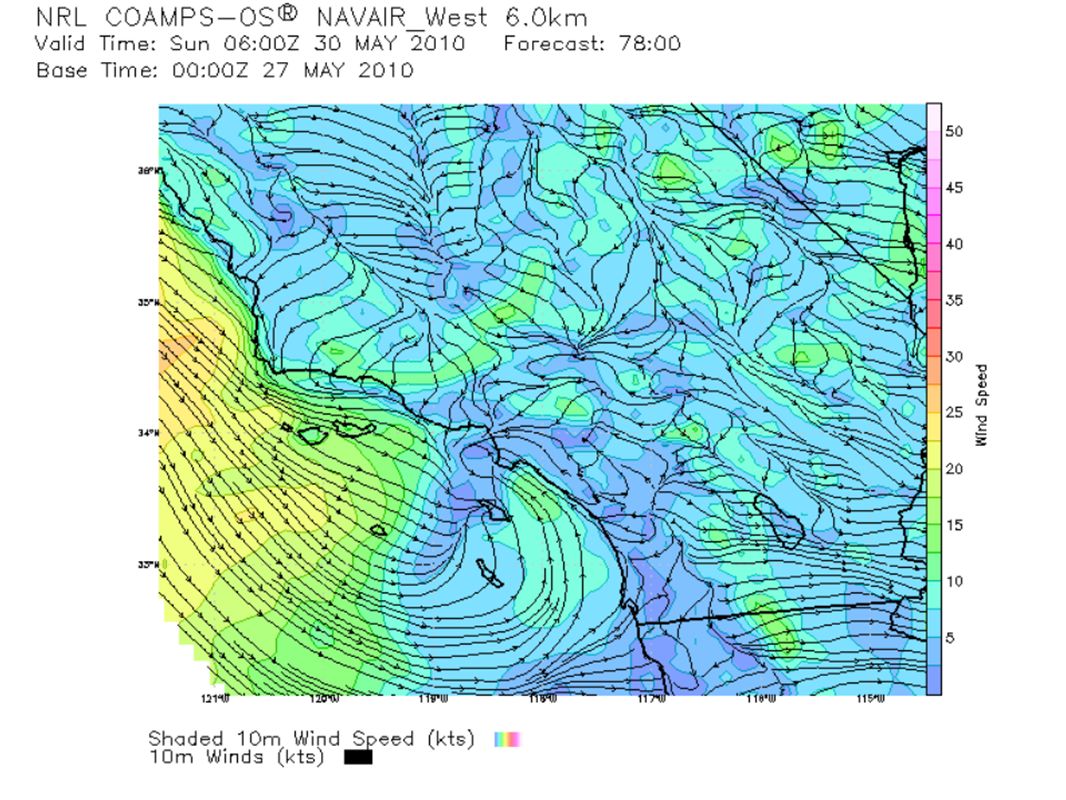
South Coast Thursday: Miramar AM sounding shows weak inversion, based at 1570 feet, expect mixing today >3300 feet; continuing cloudy & unseasonably cool (a couple of degrees cooler than Wednesday); slight chance of light rain today, mostly on northern mountain slopes; low & mid-level moisture & clouds; onshore flow; gusty winds mountains & deserts; deeper moist layer; mostly good AQ Friday: Upper low moves over Great Basin; drier NW flow will start late Thursday night & Friday; warming starts, but only a few degrees higher; clouds decrease for mostly sunny afternoon; some gusty NW winds through day; northerly surface gradients peak Friday night for strong winds on Central Coast, Santa Ynez range, Antelope Valley & I-5 corridor & some in San Fernando & Santa Clarita Valleys; Moderate Ozone Saturday: Upper ridge builds; clear skies; northerly (offshore) surface gradients; warming 10-15 degrees for above normal temps - near 90 degrees F in warmer valleys; AQ mostly Moderate, but some USG possible Sunday: warming continues with easterly offshore component; onshore gradients in afternoon; more stratus/marine layer may return to coast Sunday night with AM coastal eddy likely; USG AQ likely in eastern SoCAB
; slight chance of light rain today, mostly on northern mountain slopes; low & mid-level moisture & clouds; onshore flow; gusty winds mountains & deserts; deeper moist layer; mostly good AQ Friday: Upper low moves over Great Basin; drier NW flow will start late Thursday night & Friday; warming starts, but only a few degrees higher; clouds decrease for mostly sunny afternoon; some gusty NW winds through day; northerly surface gradients peak Friday night for strong winds on Central Coast, Santa Ynez range, Antelope Valley & I-5 corridor & some in San Fernando & Santa Clarita Valleys; Moderate Ozone Saturday: Upper ridge builds; clear skies; northerly (offshore) surface gradients; warming degrees for above normal temps - near 90 degrees F in warmer valleys; AQ mostly Moderate, but some USG possible Sunday: warming continues with easterly offshore component; onshore gradients in afternoon; more stratus/marine layer may return to coast Sunday night with AM coastal eddy likely; USG AQ likely in eastern SoCAB")
58
South Coast (cont) Monday & Tuesday: temps remain above normal, but a little cooler Monday & Tuesday as a weak flat trough moves into West Coast; marine layer may return for more coastal AM stratus Wednesday +: optimistically heading into a more normal ridging/stagnant pattern Wednesday for the rest of the week for warming & greater chance of USG ozone inland
 Monday & Tuesday: temps remain above normal, but a little cooler Monday & Tuesday as a weak flat trough moves into West Coast; marine layer may return for more coastal AM stratus Wednesday +: optimistically heading into a more normal ridging/stagnant pattern Wednesday for the rest of the week for warming & greater chance of USG ozone inland")
59
Northern California Observed, Model-Interpolated Winds for SF Bay http://sfports.wr.usgs.gov/cgi-bin/wind/windbin.cgi and COAMPS Wind Plots http://www.sccoos.org/data/coamps/coamps.html

Similar presentations


 Prepared by Jennie Moody (UVA) and Mike Porter (FSU)>")


 …what development was forecast? Lecture 26: Map discussion 12Z Wed (analysis)>")


 CONFERENCE CALL Wednesday 2:30 PM February 6, 2013.>")