Download presentation
Presentation is loading. Please wait.

1
Uploading Data Matthew Hanson mhanson@ags.io

2
GeoNode made up of several components Web Framework – Django OGC Server – GeoServer Database – PostGIS A library, for geospatial data View/upload/edit through website Use services from external clients Quantum GIS (QGIS) – connect to Web Mapping Service (WMS)
 – connect to Web Mapping Service (WMS)")
3
Projections identified by EPSG code (most common) epsg.io – website reference for all projections Common Projections EPSG:4326 – Geographic or ‘WGS-84’ units in degrees EPSG:3857 – Web Macator or “Google” projection used for viewing (google maps, openlayers) Equal area projections useful for analysis EPSG:42303 – Albers North America Units in meters UTM – Universal Transverse Mercator Smaller areas called zones (each one different EPSG code) Units in meters For uploads the projection doesn’t really matter…
 epsg.io – website reference for all projections Common Projections EPSG:4326 – Geographic or ‘WGS-84’ units in degrees EPSG:3857 – Web Macator or Google projection used for viewing (google maps, openlayers) Equal area projections useful for analysis EPSG:42303 – Albers North America Units in meters UTM – Universal Transverse Mercator Smaller areas called zones (each one different EPSG code) Units in meters For uploads the projection doesn’t really matter…")
4
Layers Collection of data Vector Collection of one geometry type (e.g., polygon, linestring, etc) Raster Collection of raster bands (e.g., colors) Metadata Abstract, source, temporal and spatial extent, point of contact Maps Collection of multiple layers of data
 Raster Collection of raster bands (e.g., colors) Metadata Abstract, source, temporal and spatial extent, point of contact Maps Collection of multiple layers of data")
5
Front page Recent layers and maps Links to main pages Upload Layers Create Maps Explore (Browse) Search Future options News/blog Featured apps or data
 Search Future options News/blog Featured apps or data")
6
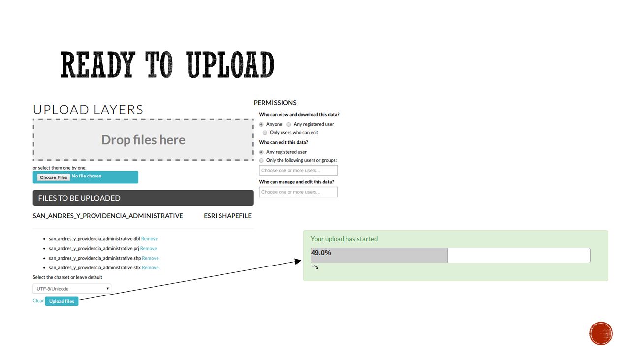
Upload multiple files Any combo of raster/vector Drag and Drop File Dialog Batch permissions Other batch options GeoServer PostGIS GeoNode command line

7
Vector Uploads ESRI Shapefiles files .shp - geometry .shx – index .dbf – attributes .prj – projection .sld – style (optional) .xml – metadata (optional) Zip file containing all of above Raster Uploads GeoTiff May contain multiple bands
 .xml – metadata (optional) Zip file containing all of above Raster Uploads GeoTiff May contain multiple bands")
8
Layer Permissions Set when uploading Change from layer info page (must be logged in) Edit Layer -> Edit Permissions “Anyone” – means anonymous access allowed Map Permissions Set when creating Change from map info page (must be logged in) Edit Map -> Edit Map Permissions Groups Not in current version (2.0) Feature added in 2.1
 Edit Layer -> Edit Permissions Anyone – means anonymous access allowed Map Permissions Set when creating Change from map info page (must be logged in) Edit Map -> Edit Map Permissions Groups Not in current version (2.0) Feature added in 2.1")
10
If successfully uploaded, the message above will be displayed Layer Info main layer viewing page Edit Metadata Fill in metadata…..very important! Spatial data without metadata is of limited use (when, where, why, contact?) Manage Styles Edit, or create new, styles for the layer All styles available with this layer to users
 Manage Styles Edit, or create new, styles for the layer All styles available with this layer to users.")
11
Each layer (or map) has own Info page View data (zoom/pan) Feature Info (e.g. polygon attributes) Download data Variety of formats (e.g., tif, shapefile, jpg, kml) Download metadata Varity of formats (e.g., DIF, ATOM, ISO) Replace or remove data Social features Comment, rate, share
 Download data Variety of formats (e.g., tif, shapefile, jpg, kml) Download metadata Varity of formats (e.g., DIF, ATOM, ISO) Replace or remove data Social features Comment, rate, share.")
12
Data layers may have multiple styles Add new or duplicate Use Style Manager to select available styles Style information stored in.sld files Include.sld file during upload Use GUI to edit rules Vector styling full featured Complex raster styles more difficult

Similar presentations


 Data Marcel Fortin Geographic Information Systems (GIS) and Map Librarian Map and Data Library December 7, 2009.>")

 Aleda Freeman MassGIS (Office.>")

