Download presentation
Presentation is loading. Please wait.

1
CalNex Forecast Prepared Monday 21 June 2010

2
Anticipated Flights NOAA P3 Mon: No Flights - packing Tue: Measurements during transit to Colorado NOAA Twin Otter Mon: Morning & afternoon flights in Sac area Tue: CARES DOE G-1 and NASA B200 Mon: Sac/N SJV flights Tue: afternoon flight possible Wed: Flights likely Thu: Flights likely, if no flight Tuesday

3
Local Features Monday light NW winds clear SF emissions from Sac Valley and carry fresh Sac and SF emissions to SJV Lawrence Livermore Natl Lab still conducting prescribed grass burns (200-300 acres) when winds OK enhanced bkg O3 production in San Francisco Bay Area Tuesday improving flow into Sac Vly but Sac plume largely south of Cool Lawrence Livermore Natl Lab still conducting prescribed grass burns (200-300 acres) when winds OK Moderate (5-10ppbv/day) background O3 P-L between SF and Sac. USG for O3 possible in southern SJVLA Basin emissions transport east to desert Wednesday o improved flow pattern for Sac to Cool transport but mid & high level clouds (>20k ft base) o USG for O3 possible in southern SJV Thursday good flow pattern for Sac to Cool transport but some mid & high level clouds (>15k ft base) USG for O3 possible in southern SJV
 o USG for O3 possible in southern SJV Thursday good flow pattern for Sac to Cool transport but some mid & high level clouds (>15k ft base) USG for O3 possible in southern SJV.")
4
Synoptic Overview for California Monday June 21 Weak baggy trough extends from ID southwest to SoCal Transport flow: SW in SoCal, N/NW in the north SoCal surface flow is weak onshore with marine stratus present North winds for the Valleys Tuesday June 22 Weak ridging moves through the state Weak onshore flow late for all areas Wednesday June 23 Next trough digs south from PacNW Onshore flow increases in the north Beyond… Longwave trough over CA through Fri Transitory ridge for Sat Another trough for the north Sunday, ridging south

5
Analysis GFS – 00 Z Monday – Sun 17 PDT

6
12 hour GFS – 12 Z Monday – 05 PDT

7
24 hour GFS – 00 Z Tuesday – Mon 17 PDT

8
36 hour GFS – 12 Z Tuesday – 05 PDT

9
48 hour GFS – 00 Z Wednesday – Tue 17 PDT

10
60 hour GFS – 12 Z Wednesday – 05 PDT

11
GFS 3 day – 00 Z Thursday – Wed 17 PDT

12
ECMWF 3 day – 00 Z Thursday – Wed 17 PDT

13
3.5 day GFS – 12 Z Thursday – 05 PDT

14
4 day GFS – 00 Z Friday – Thu 17 PDT

15
4 day ECMWF – 00 Z Friday – Thu 17 PDT

16
5 day GFS – 00 Z Saturday – Fri 17 PDT

17
5 day ECMWF – 00 Z Saturday – Fri 17 PDT

21
Large Scale Transport RAQMS FX updated SUN, Jun 20th

22
500m CO Mon afternoon

23
500m CO Tue afternoon

24
500m CO Wed afternoon

25
500m CO Thu afternoon

26
500m O3 Mon afternoon

27
500m O3 Tue afternoon

28
500m O3 Wed afternoon

29
500m O3 Thu afternoon

30
500m O3 prod Mon afternoon

31
500m O3 prod Tue afternoon

32
500m O3 prod Wed afternoon

33
500m O3 prod Thu afternoon

34
500m PM2.5 nothing noteworthy until maybe Friday

35
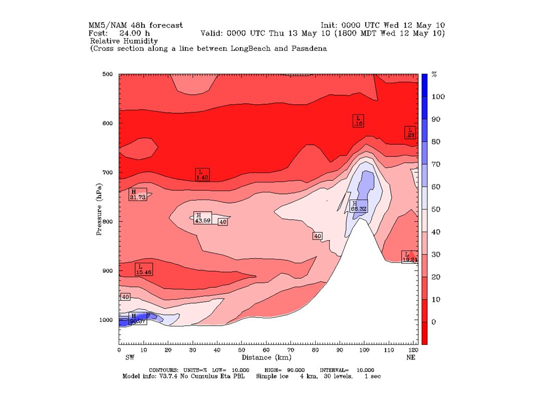
500m vertical displacement Mon afternoon

36
500m vertical displacement Tue afternoon

37
500m vertical displacement Wed afternoon

38
500m vertical displacement Thu afternoon

39
Northern California Observed, Model-Interpolated Winds for SF Bay http://sfports.wr.usgs.gov/cgi-bin/wind/windbin.cgi and COAMPS fine grid plots http://www.sccoos.org/data/coamps/coamps.html

40
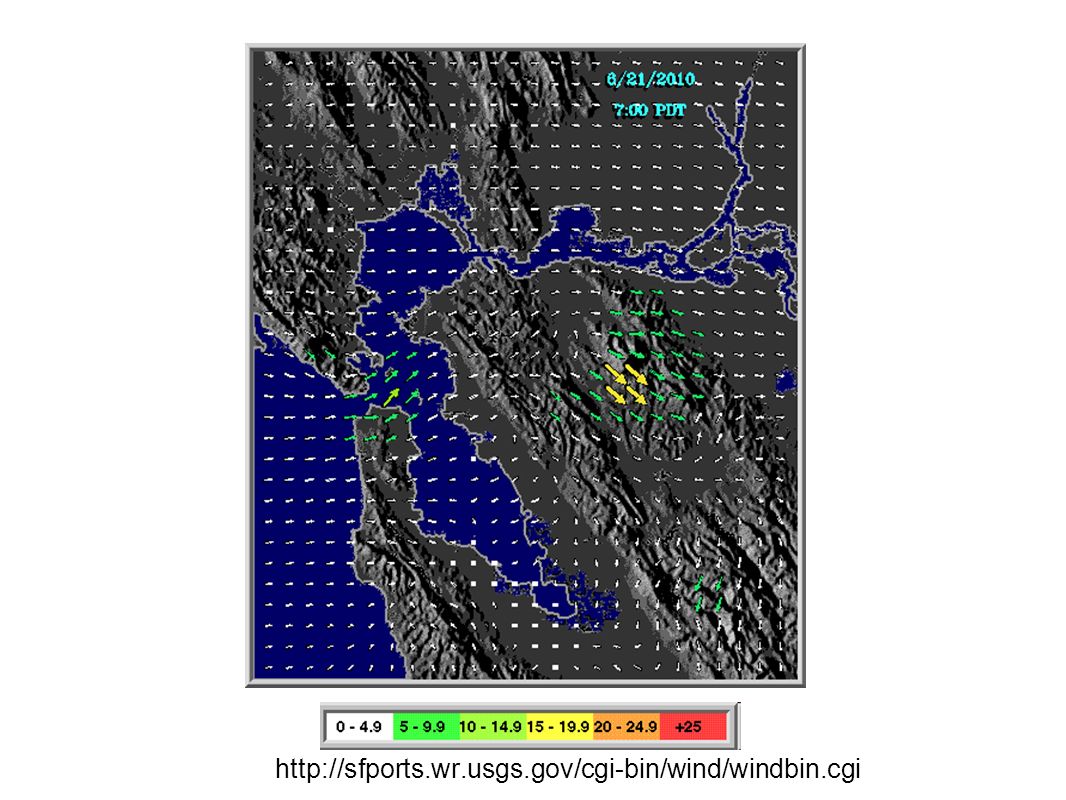
http://sfports.wr.usgs.gov/cgi-bin/wind/windbin.cgi
42
CANSAC Initialized 00 Z Monday

43
Monday 0500 PDT

44
Monday 1100 PDT

45
Monday 1700 PDT

46
Tuesday 0500 PDT

47
Tuesday 1100 PDT

48
Tuesday 1700 PDT

49
Wednesday 0500 PDT

50
Wednesday 1100 PDT

51
Wednesday 1700 PDT

52
205m passive tracer of emissions from north portion of SFBA 1700PDT Monday

53
205m passive tracer of emissions from north portion of SFBA 1700PDT Tuesday

54
205m passive tracer of emissions from north portion of SFBA 1700PDT Wednesday

55
205m passive tracer of emissions from north portion of SFBA 1700PDT Thursday

56
Sacramento Valley Monday Early AM: Presence of weak delta flow and north wind, but north wind is much weaker than what was predicted; wind profiler recording light WNW near ground level and N at 1,000ft and above Late AM: NW7kt in the valley, Sac Cnty ouflow to the E foothills PM: Onshore flow makes it way into the delta in late aftn, countered by N. wind and turns SE; N. wind dies down to below 5kt for most valley locations by late afternoon, outflow toward SE Evening: Onshore flow decreases but reaches Sac Cnty at late night, breaking the brief period of stagnation PBL below 500ft in AM; 4,000 to 6,500ft in PM MBL 500ft and below Mostly clear, cirrostratus (26Kft) leaving area in the AM Max aftn temp: 32C/89F; moderate air quality
 leaving area in the AM Max aftn temp: 32C/89F; moderate air quality.")
57
Sacramento Valley (cont'd) Tuesday Early AM: Downslope flow strong in some areas but weak in Sac Cnty due to countering from weak onshore flow, SW2kt in Sac Cnty Late AM: Late N. wind dies down over the western edge of valley, Sac Cnty remains light NW until aftn, foothills area light and variable as it switches from downslope to upslope flow Late afternoon: Onshore flow from E. Bay begins to reach lower Sac Cnty, but majority of flow turns toward SJV; outflow from Downtown towards ESE in late afternoon; GFS predicts stronger onshore flow for Sac Cnty WSW5kt and SW 9kt in early and late aftn, respectively Weak delta and downslope flow at night GFS: Cirrostratus (24-28Kft) all day, altocumulus (21Kft) at night; COAMPS: 30-40Kft cirrostratus all day; 20-25Kft altocumulus in afternoon PBL below 500ft in AM, around 4,000ft in PM for S. SV, lower for N. SV MBL 500ft and below Max aftn temp: 34C/94F; moderate air quality
 all day, altocumulus (21Kft) at night; COAMPS: 30-40Kft cirrostratus all day; 20-25Kft altocumulus in afternoon PBL below 500ft in AM, around 4,000ft in PM for S. SV, lower for N. SV MBL 500ft and below Max aftn temp: 34C/94F; moderate air quality.")
58
Sacramento Valley (cont'd) Wednesday AM: Weak onshore toward Sac Cnty, weak downslope flow elsewhere in valley in early AM; valley remains light and variable throughout the morning Early PM: Stronger onshore from N. Bay toward SV; Sac Cnty at SW4kt and outflow toward NE foothills, late aftn wind becomes WSW 5kt; CANSAC predicts light wind in N. SV, probably should be W5kt PBL below 500ft, 5,000ft in PM MBL around 500ft GFS: Cirrostratus/altostratus/altocumulus (21Kft) in and out through the day; COAMPS: 30-40Kft cirrostratus in the day; 15-30Kft altostratus/altocumulus in the afternoon Max aftn temp: 32C/90F; moderate air quality Thursday Light onshore flow throughout the day becomes stronger in the afternoon Altocumulus/altostratus in the area throughout the day Max aftn temp: 31C/88F; good air quality
 in and out through the day; COAMPS: 30-40Kft cirrostratus in the day; 15-30Kft altostratus/altocumulus in the afternoon Max aftn temp: 32C/90F; moderate air quality Thursday Light onshore flow throughout the day becomes stronger in the afternoon Altocumulus/altostratus in the area throughout the day Max aftn temp: 31C/88F; good air quality.")
59
Sacramento Trajectory (Mon)
")
60
Sacramento Trajectory (Tue)
")
61
Sacramento Trajectory (Wed)
")
62
San Joaquin Valley Monday June 21 Surface Winds: The surface observations this morning show light and variable wind flow from Merced county southward. Light northwesterly winds are present in San Joaquin and Stanislaus Counties. The wind profilers show light northwesterly wind flow up to 3,000 feet, turning light and variable above. The 0Z CANSAC shows light NW flow throughout the SJV this afternoon. The Delta and Altamont passes are shut-off by the north to northwesterly flow from SAC Valley. Weak onshore flow will begin around 3Z tonight, with light and variable winds developing over the rest of the SJV. Outflow will be toward the Deserts and SLO. Boundary Layer Mixing: Maximum boundary layer mixing depths will be between 2,500 to 5,000 feet this afternoon. Limited mixing depths are forecast along the western parts of the SJV. Air Quality: Good to Moderate ozone air quality is expected across the SJV. Tuesday June 22 Surface Winds: CANSAC shows similar wind conditions on Tuesday compared to Monday, with the exception onshore flow will commence around 0Z and be a little stronger. Winds across the rest of the SJV will be thermally driven, with light to moderate northwesterly wind flow developing over the District during the afternoon hours. Boundary Layer Mixing: CANSAC indicates that mixing depths should be between 2,500 to 5,000 feet across the SJV. Limited mixing depths are forecast for along the western parts of the SJV. Air Quality: Good to Moderate ozone air quality is expected across the SJV. Possible USG over Kern, Tulare, Kings, and Fresno Counties.

63
San Joaquin Valley (cont'd) Wednesday June 23 Surface Winds: CANSAC shows thermally driven surface winds dominating. Very light onshore flow is possible by the afternoon hours. Boundary Layer Mixing: CANSAC indicates that maximum boundary layer mixing heights will range from 2,500 to 5,000 feet. Air Quality: Good to Moderate ozone air quality is expected across the SJV. USG possible over the central and south end of the SJV. Thursday June 24 and Friday June 25 Surface Winds: Surface wind flow in the SJV will be mainly thermally driven, with light onshore flow conditions continuing through the forecast period. Potential for stronger onshore flow conditions depending on how the trough influences the marine layer along the coast. Boundary Layer Mixing: Boundary layer mixing depths will remain steady through the period. Air Quality: Good to moderate AQI is predicted from Madera counties northward, with USG possible from Fresno county southward. *Potential Targets for next Flight Day* The LLNL prescribed burn SW of Tracy is scheduled for today, given that they are within their prescription.

64
Central Coast NO FORECAST until operations in SoCal

65
Southern Coastal Waters NO FORECAST until operations in SoCal

66
South Coast Air Basin NO FORECAST until operations in SoCal

67
205m passive tracer of emissions from LA Basin 1700PDT Tuesday

Similar presentations


 Prepared by Jennie Moody (UVA) and Mike Porter (FSU)>")


 CONFERENCE CALL Wednesday 2:30 PM February 6, 2013.>")


;>")
