Download presentation
Presentation is loading. Please wait.

1
CalNex Forecast Prepared Sunday 6 June 2010

2
Anticipated Platform Activities NOAA P3 Sun: SoCal day flight Mon: SJV day flight Tue: No Flight (50-hr maintenance); beyond - likely Gulf deployment NOAA Twin Otter Sun: afternoon flight in LA, Mojave, & Imperial Valley Mon: morning flight in LA Basin; afternoon flight in LA, Mojave, & southern SJV Tue: No Flight Wed: transit to Sacramento, sampling Central Valley Thu - Mon: No Flights - maintenance R/V Atlantis Sun - Tue: offshore DOE G-1 & NASA B-200 (CARES - http://campaign.arm.gov/cares)http://campaign.arm.gov/cares Sat: B-200 Flight (Sac, Fresno, Monterey, SFBA, Sac) Sun: morning and afternoon flights Mon: morning and afternoon flights Tue: No Flights (if fly both Sun & Mon)
; beyond - likely Gulf deployment NOAA Twin Otter Sun: afternoon flight in LA, Mojave, & Imperial Valley Mon: morning flight in LA Basin; afternoon flight in LA, Mojave, & southern SJV Tue: No Flight Wed: transit to Sacramento, sampling Central Valley Thu - Mon: No Flights - maintenance R/V Atlantis Sun - Tue: offshore DOE G-1 & NASA B-200 (CARES - Sat: B-200 Flight (Sac, Fresno, Monterey, SFBA, Sac) Sun: morning and afternoon flights Mon: morning and afternoon flights Tue: No Flights (if fly both Sun & Mon)")
3
Local Features Sun: Sac: Sac plume to northeast, moderate air quality SJV: good to moderate air quality - poorer air quality in southern portion of SJV SoCal: tracer model of LA pollution indicates strongest early morning offshore push of weekend; O3 air quality anticipated to be USG or higher in eastern LA basin; LA plume to desert (more east (Banning) than north (Cajon)) Mon: Sac: Sac plume toward receptor site; moderate air quality SJV: good to moderate air quality - poorer air quality in southern portion of SJV; SoCal: LA plume to desert (more east (Banning) than north (Cajon) Tue: SJV: descending air with high O3 over southern SJV; small recirculation eddy in south valley in morning Wed: SJV: if flight range permits, TO flight to Sac could look for O3 along west side of SJV and coastal ridge line; small recirculation eddy in south valley in morning Flight Recommendations: Sunday flight track(s) include LA plume in bight in morning and in desert in afternoon; Monday flight: Sac plume looks promising for CARES Tuesday flight(s): Sac plume not promising for CARES; southern SJV may have high O3 in descending air mass
 than north (Cajon)) Mon: Sac: Sac plume toward receptor site; moderate air quality SJV: good to moderate air quality - poorer air quality in southern portion of SJV; SoCal: LA plume to desert (more east (Banning) than north (Cajon) Tue: SJV: descending air with high O3 over southern SJV; small recirculation eddy in south valley in morning Wed: SJV: if flight range permits, TO flight to Sac could look for O3 along west side of SJV and coastal ridge line; small recirculation eddy in south valley in morning Flight Recommendations: Sunday flight track(s) include LA plume in bight in morning and in desert in afternoon; Monday flight: Sac plume looks promising for CARES Tuesday flight(s): Sac plume not promising for CARES; southern SJV may have high O3 in descending air mass")
4
Synoptic Overview for California Sunday June 6 Zonal flow north, ridge south Onshore gradients south, weak onshore north Deeper marine layer in the south then in previous mornings Monday June 7 Ridge is pushed S/E by another PacNW trough Onshore flow increases for the south Weak onshore north Tuesday June 8 Zonal flow pushes farther south as ridge shifts east Onshore flow resumes in the north, continues in the south Wednesday-Friday Trough pushes south out of PacNW for Wed for N.Ca Trough digs south into So Cal Thurs/Fri

5
Analysis GFS – 00 Z Sunday – Sat 17 PDT

6
12 hour GFS – 12 Z Sunday – 05 PDT

7
24 hour GFS – 00 Z Monday – Sun 17 PDT

8
36 hour GFS – 12 Z Monday – 05 PDT

9
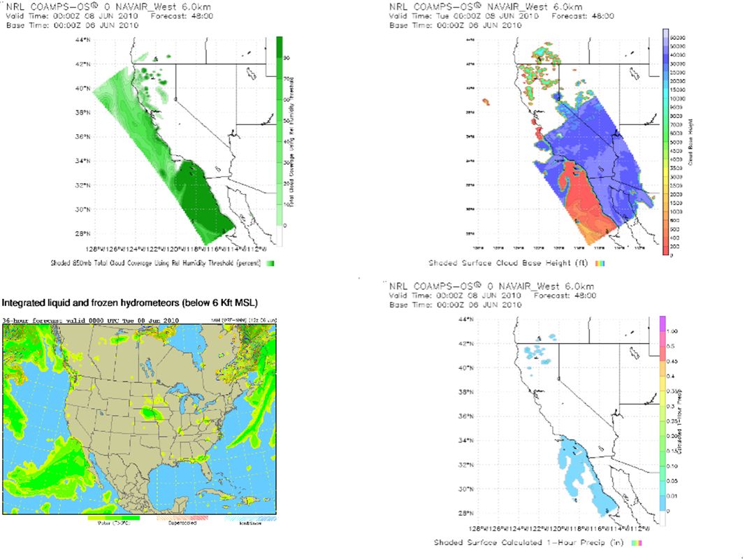
48 hour GFS – 00 Z Tuesday – Mon 17 PDT

10
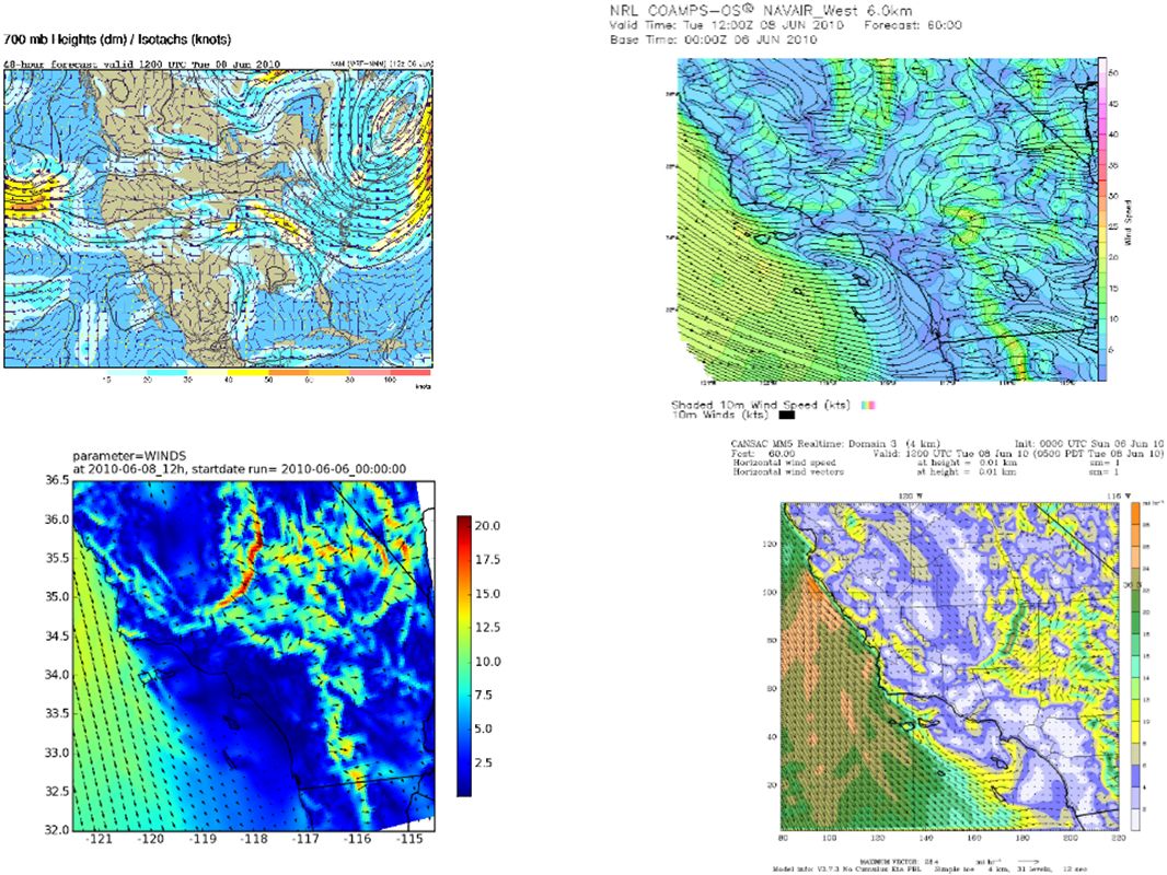
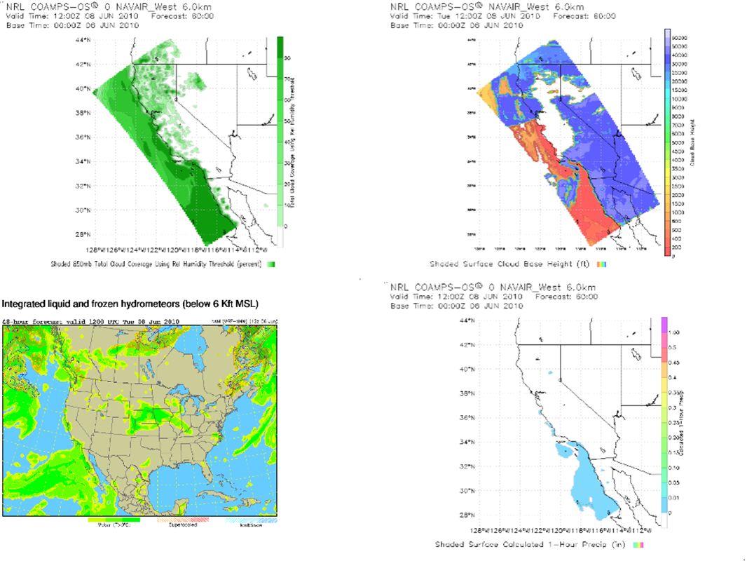
60 hour GFS – 12 Z Tuesday – 05 PDT

11
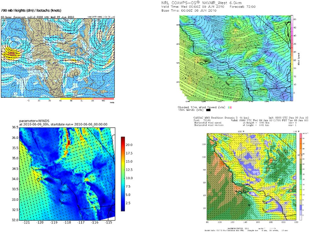
GFS 3 day – 00 Z Wednesday – Tue 17 PDT

12
ECMWF 3 day – 00 Z Wednesday – Tue 17 PDT

13
3.5 day GFS – 12 Z Wednesday – 05 PDT

14
4 day GFS – 00 Z Thursday – Wed 17 PDT

15
4 day ECMWF – 00 Z Thursday – Wed 17 PDT

16
5 day GFS – 00 Z Friday – Thu 17 PDT

17
5 day ECMWF – 00 Z Friday – Thu 17 PDT

18
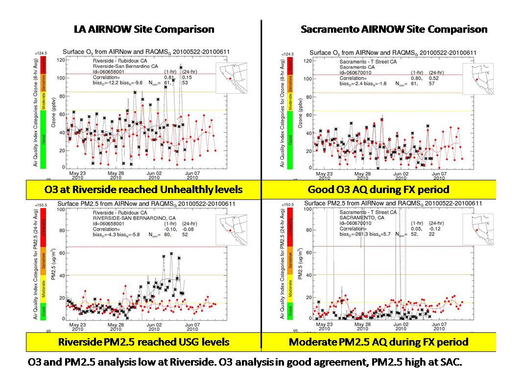
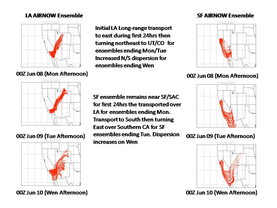
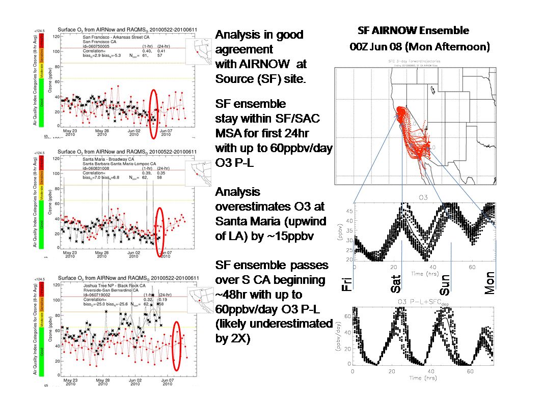
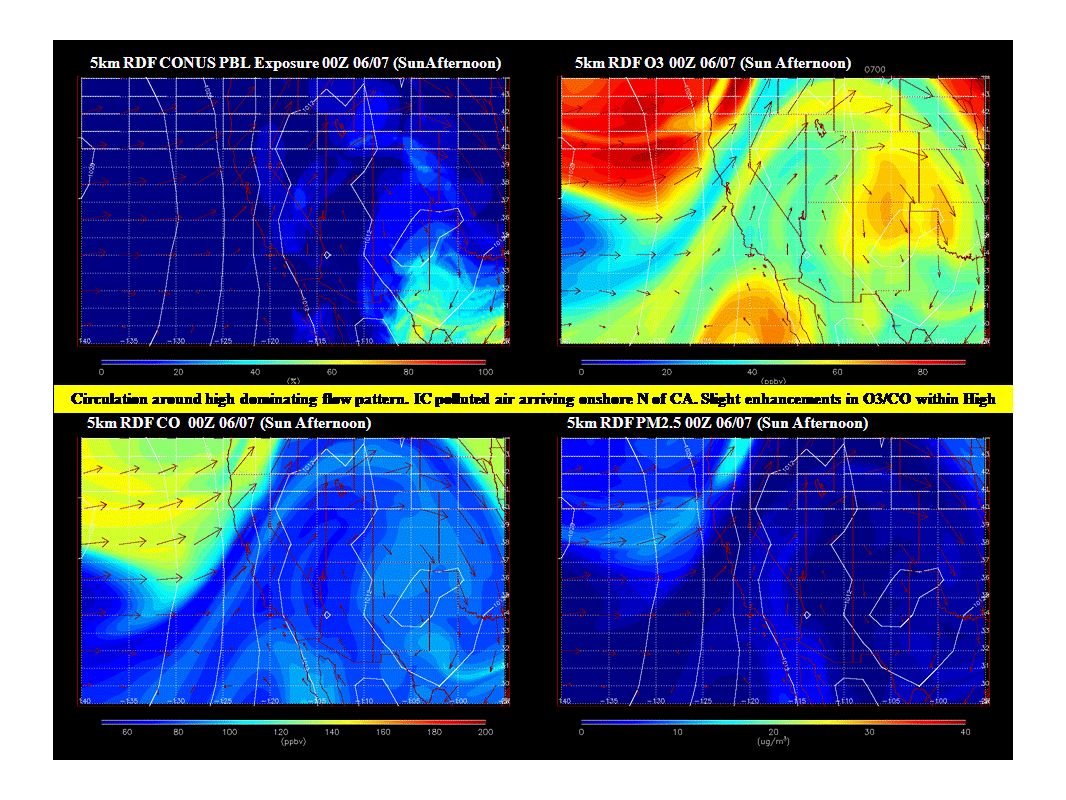
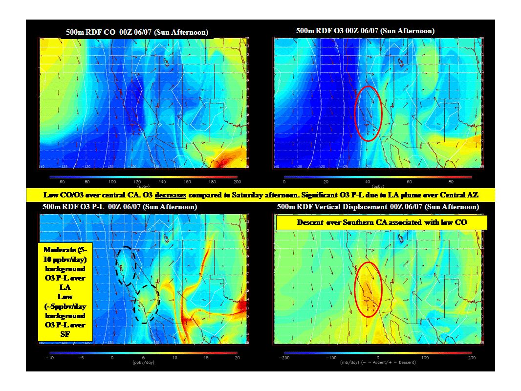
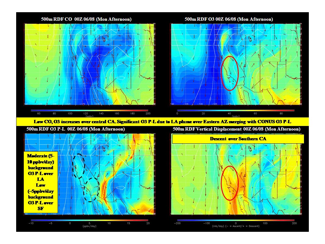
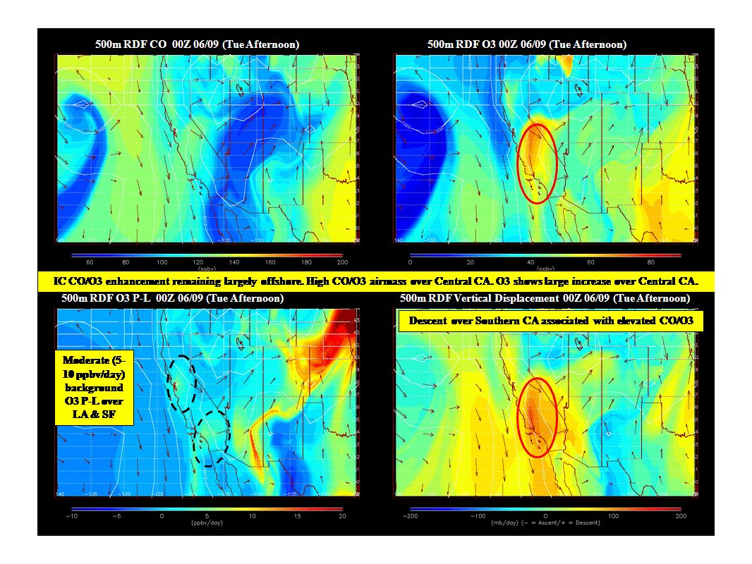
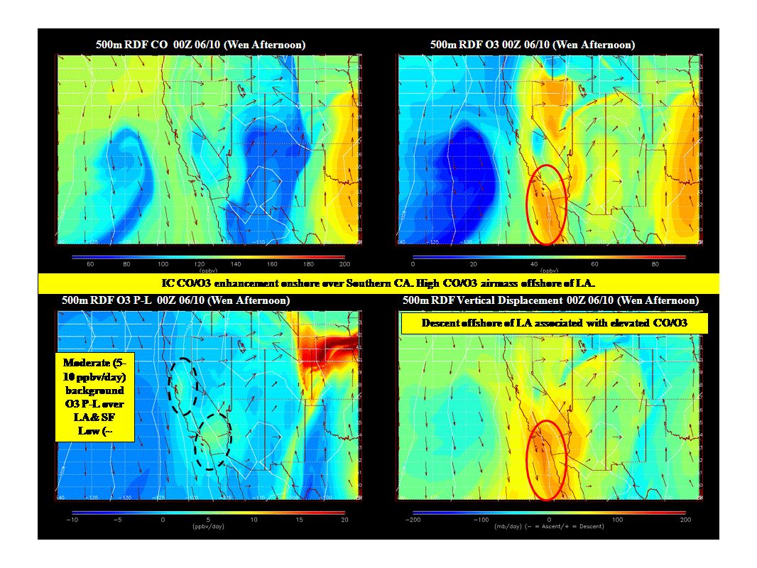
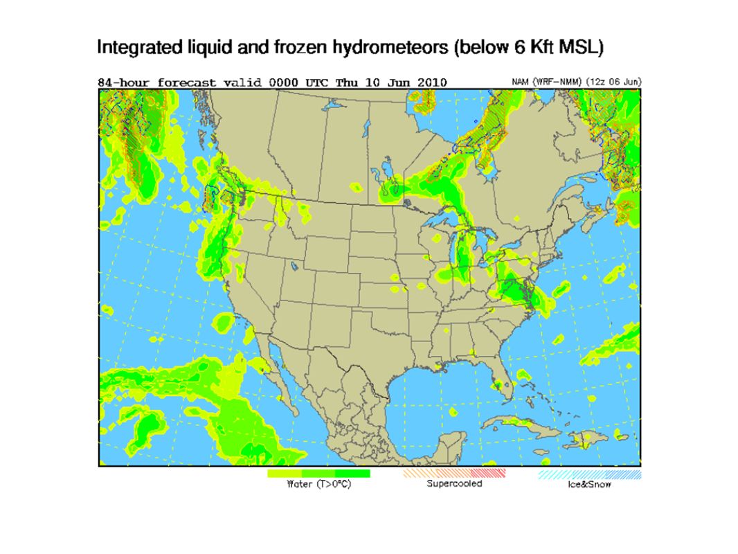
Large Scale Transport RAQMS FX updated Sun, Jun 06th

27
SF Bay Area (updated 00Z 06 Jun 2010) Sunday NW 10kt strengthens through the day to 15kt in the aftn and continues overnight MBL below 500ft Monday NW 15 to 20kt MBL below 500ft, increase slightly during the day Tuesday NW 15kt shifts W and lightens in the aftn; W 5kt at night and shifts S overnight MBL 500 increase to 1,500 ft Wednesday W to SW 5kt in early AM; W 10kt in late AM; NW 15kt resumes in late aftn and strengthen overnight Extended NW continues Thu and Friday; strongest on Thu aftn (gale wind further off coast), moderate on Friday
 Sunday NW 10kt strengthens through the day to 15kt in the aftn and continues overnight MBL below 500ft Monday NW 15 to 20kt MBL below 500ft, increase slightly during the day Tuesday NW 15kt shifts W and lightens in the aftn; W 5kt at night and shifts S overnight MBL 500 increase to 1,500 ft Wednesday W to SW 5kt in early AM; W 10kt in late AM; NW 15kt resumes in late aftn and strengthen overnight Extended NW continues Thu and Friday; strongest on Thu aftn (gale wind further off coast), moderate on Friday")
29
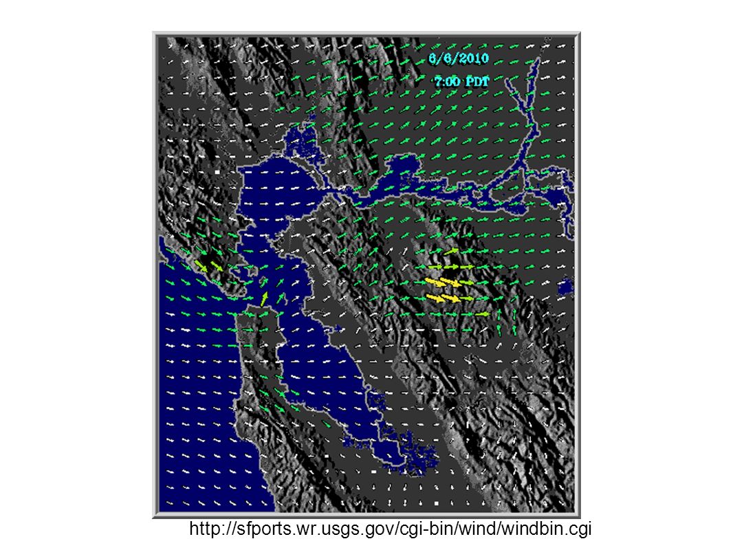
http://sfports.wr.usgs.gov/cgi-bin/wind/windbin.cgi
30
Sacramento Valley Sunday Northern SV - SE 5kt downslope flow; becomes S by late morning; returns to downslope pattern at late night Southern SV - SW 5kt; becomes W around mid-AM and reaches 10kt in the afternoon; returns to SW 5kt at late night W wind from north of Pt. Reyes yields weaker flow from delta AM PBL mostly 500ft; PM PBL 2,000 to 4,000ft Clear, with some cirrus Max aftn temp: 30C; moderate air quality with max-8hr mean O3 in 0.05-0.06 ppm range Monday Northern SV - ESE below 5kt; S by late mrng; SE at late night Southern SV - SW 5kt almost entire day, below 5kt around late mrng to aftn AM PBLaround 1,000; PM PBL 2,500 to 4,000ft Mostly clear except for cirrostratus in the mrng and thins in the aftn Max aftn temp: 29C, moderate air quality, max-8hr mean O3 in 0.05-0.06 ppm range

31
Sacramento Valley (cont'd) Tuesday Northern SV - SE 5 to 10kt early AM, shifts S by mid-mrng; becomes SW 10kt in the aftn; SE 10kt at night Southern SV - SW 5kt, strengthen to 10kt in late aftn; 5 to 10kt at night AM PBL around 1,000ft; PM PBL 3,000 to 5,000ft Scattered cirrus in the morning; cirrostratus moves through in the afternoon Max aftn temp: 27C; good air quality, max-8hr mean O3 in 0.05 ppm range Wednesday Northern SV - SE 5 to 10kt early AM, shift S around late AM; becomes SW 10kt in the aftn; lightens to 5kt at night Southern SV - SW 5kt; shifts WSW 10kt in the aftn; SW 5kt at night Partly cloudy, mainly with altocumulus in AM; 10% chance of rain Max aftn temp: 26C; good air quality, max-8hr mean O3 in 0.04 ppm range Extended Wind shifts NWly Thu mrng; gusty NW wind on Fri No clouds Max aftn temp warms to high 20s C; good air quality
 Tuesday Northern SV - SE 5 to 10kt early AM, shifts S by mid-mrng; becomes SW 10kt in the aftn; SE 10kt at night Southern SV - SW 5kt, strengthen to 10kt in late aftn; 5 to 10kt at night AM PBL around 1,000ft; PM PBL 3,000 to 5,000ft Scattered cirrus in the morning; cirrostratus moves through in the afternoon Max aftn temp: 27C; good air quality, max-8hr mean O3 in 0.05 ppm range Wednesday Northern SV - SE 5 to 10kt early AM, shift S around late AM; becomes SW 10kt in the aftn; lightens to 5kt at night Southern SV - SW 5kt; shifts WSW 10kt in the aftn; SW 5kt at night Partly cloudy, mainly with altocumulus in AM; 10% chance of rain Max aftn temp: 26C; good air quality, max-8hr mean O3 in 0.04 ppm range Extended Wind shifts NWly Thu mrng; gusty NW wind on Fri No clouds Max aftn temp warms to high 20s C; good air quality")
32
Sacramento Trajectories (Sun)
")
33
Sacramento Trajectories (Mon)
")
34
Sacramento Trajectories (Tue)
")
35
San Joaquin Valley Sunday June 6 Surface Winds: Surface obs this morning: Light to moderate NW flow across most of the SJV. The wind profilers show a light to moderate N to NW flow above the surface across the SJV. CANSAC shows light to moderate W to NW flow over Delta, Altamont and Pacheco Passes this afternoon into the early evening hours. Light S to SE flow is present over Kern County by 6 Z this evening. Outflow over the passes throughout the day and night. Upslope flow in the afternoon stops after sunset with weak flow (downslope) thereafter over the Sierra's. Very weak NW flow will continue overnight on the valley floor. Boundary Layer Mixing: CANSAC shows that maximum boundary layer mixing depths will range from 3,000 to 5,000 feet from Fresno county southward. Maximum mixing depths between 2,500 and 3,000 feet from Madera county northward. Air Quality: Good to extremely low end moderate air quality (south end of Valley) due to ozone. Monday June 7 into Tuesday June 8 Surface Winds: CANSAC shows light to moderate onshore flow occuring during the day on Monday over the northern SJV. Weak flow from Kern County toward SLO will be present during the afternoon hours. Moderate outflow will continue out toward the Deserts by the late afternoon into the evening hours. Overnight wind flow into the early morning hours on Tuesday shows the potential of a weak eddy circulation forming in Kern and Tulare Counties. By the afternoon hours, light northwesterly thermally driven wind flow will have developed over the entire SJV on Tuesday. Boundary Layer Mixing: CANSAC shows that maximum mixing depths will range from 3,000 to 5,000 feet District-wide on both Monday and Tuesday. Air Quality: Good to low end moderate AQ due to ozone. Moderate AQ possible in southern SJV.
 thereafter over the Sierra s. Very weak NW flow will continue overnight on the valley floor. Boundary Layer Mixing: CANSAC shows that maximum boundary layer mixing depths will range from 3,000 to 5,000 feet from Fresno county southward. Maximum mixing depths between 2,500 and 3,000 feet from Madera county northward. Air Quality: Good to extremely low end moderate air quality (south end of Valley) due to ozone. Monday June 7 into Tuesday June 8 Surface Winds: CANSAC shows light to moderate onshore flow occuring during the day on Monday over the northern SJV. Weak flow from Kern County toward SLO will be present during the afternoon hours. Moderate outflow will continue out toward the Deserts by the late afternoon into the evening hours. Overnight wind flow into the early morning hours on Tuesday shows the potential of a weak eddy circulation forming in Kern and Tulare Counties. By the afternoon hours, light northwesterly thermally driven wind flow will have developed over the entire SJV on Tuesday. Boundary Layer Mixing: CANSAC shows that maximum mixing depths will range from 3,000 to 5,000 feet District-wide on both Monday and Tuesday. Air Quality: Good to low end moderate AQ due to ozone. Moderate AQ possible in southern SJV..")
36
San Joaquin Valley (cont'd) Wednesday and Thursday June 9 and 10 Surface Winds: As the trough develops over the West Coast, onshore winds will strengthen over the SJV. Northwesterly wind flow will steadily increase over the entire SJV beginning late Wednesday into Thursday. Potential thermal circulation pattern may be present on Wednesday morning. Boundary Layer Mixing: Boundary layer mixing depths will steadily improve through the later part of the work week under decreasing stability. Air Quality: Good AQ expected due to ozone. *Potential Targets for next Flight Day* Kern County will be the best target due to possibility of moderate AQ due to ozone. Re-circulation patterns may be present on Tuesday and Wednesday mornings.

37
Central Coast NO FORECAST TODAY

38
Southern Coastal Waters

55
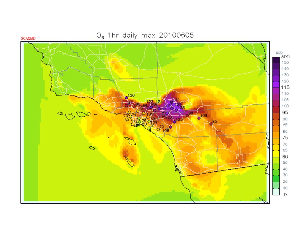
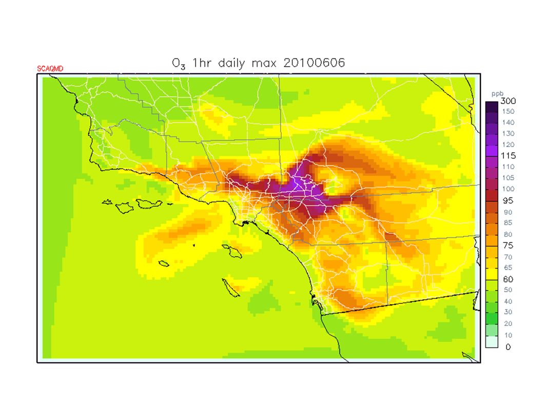
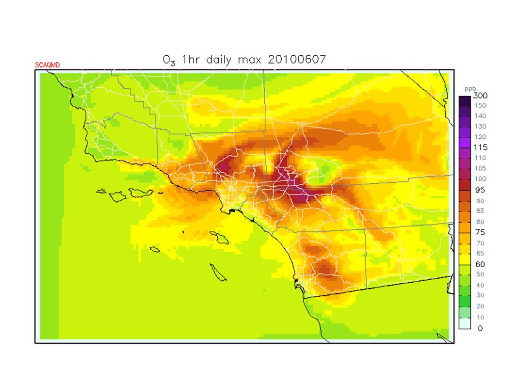
South Coast Saturday: ozone to Unhealthy (8-hr 123, 1-hr 141 ppb @ Crestline); NOTE: fire in Wilmington at auto recycling yard burning since Saturday morning & still burning Sunday morning http://cbs2.com/local/large.fire.at.2.1734770.html Sunday: Miramar AM inversion base 1800 ft, very saturated below; persistent coastal eddy; low clouds & fog to the mountains; clearing to beaches this aftenoon; less northerly gradient; stronger onshore gradients today; warmer inland today than Saturday; ozone to USG with some Unhealthy possible in Crestline & Riverside areas Monday: coastal eddy persists; high pressure aloft weakens slightly; marine layer deepens a little; AM stratus clearing to beaches; temps still warm inland; ozone to USG with Unhealthy possible inland Tuesday: ridge weakens further; gradual cooling trend; ozone to USG with small chance of Unhealthy inland Wednesday: weak troughing aloft (~ flat over so Cal); deeper marine layer; AM low clouds & fog; ozone mostly moderate, some USG inland Thursday +: west coast trough builds; deeper marine layer; AM low clouds & fog; possible stronger N gradient developing; some gusty winds mountains & deserts; temps near normal by Friday; ozone mostly moderate, some USG still possible inland
; NOTE: fire in Wilmington at auto recycling yard burning since Saturday morning & still burning Sunday morning Sunday: Miramar AM inversion base 1800 ft, very saturated below; persistent coastal eddy; low clouds & fog to the mountains; clearing to beaches this aftenoon; less northerly gradient; stronger onshore gradients today; warmer inland today than Saturday; ozone to USG with some Unhealthy possible in Crestline & Riverside areas Monday: coastal eddy persists; high pressure aloft weakens slightly; marine layer deepens a little; AM stratus clearing to beaches; temps still warm inland; ozone to USG with Unhealthy possible inland Tuesday: ridge weakens further; gradual cooling trend; ozone to USG with small chance of Unhealthy inland Wednesday: weak troughing aloft (~ flat over so Cal); deeper marine layer; AM low clouds & fog; ozone mostly moderate, some USG inland Thursday +: west coast trough builds; deeper marine layer; AM low clouds & fog; possible stronger N gradient developing; some gusty winds mountains & deserts; temps near normal by Friday; ozone mostly moderate, some USG still possible inland")
59
Northern California Observed, Model-Interpolated Winds for SF Bay http://sfports.wr.usgs.gov/cgi-bin/wind/windbin.cgi and COAMPS Wind Plots http://www.sccoos.org/data/coamps/coamps.html

Similar presentations


 Prepared by Jennie Moody (UVA) and Mike Porter (FSU)>")


 …what development was forecast? Lecture 26: Map discussion 12Z Wed (analysis)>")
 fog –Steam fog Fog formation (1)by cooling…>")


 CONFERENCE CALL Wednesday 2:30 PM February 6, 2013.>")


