Download presentation
Presentation is loading. Please wait.

1
DVD Catalog of Tropical Weather Events Using Radar and Satellite Imagery Donovan Landreneau, Forecaster WFO Lake Charles, LA Southern Region Marine Conference March 17, 2004

2
What is this? Donovan Landreneau, Forecaster WFO Lake Charles, LA Southern Region Marine Conference March 17, 2004

3
What is this? Donovan Landreneau, Forecaster WFO Lake Charles, LA Southern Region Marine Conference March 17, 2004 It is a catalog describing video DVDs available to the public. The video DVDs show satellite and radar imagery ranging from entire Atlantic hurricane seasons to individual U.S. tropical storm and hurricane landfalls.

4
What is this? Donovan Landreneau, Forecaster WFO Lake Charles, LA Southern Region Marine Conference March 17, 2004 The video DVDs are recorded on 4.7 GB General Purpose DVD-R’s, and play just like a movie DVD. They should play in most DVD- ROM drives on computers with the proper DVD player software, as well as most home DVD players capable of playing DVD-R discs.

5
Is this a new concept? Donovan Landreneau, Forecaster WFO Lake Charles, LA Southern Region Marine Conference March 17, 2004

6
Is this a new concept? Donovan Landreneau, Forecaster WFO Lake Charles, LA Southern Region Marine Conference March 17, 2004 NO, the idea of seasonal imagery movies was done before. The National Hurricane Center and the National Climatic Data Center used to produce the Atlantic Hurricane Movies on 16mm film from 1971 to 1986. The production of these movies ceased after the 1986 season.

8
Is this a new concept? Donovan Landreneau, Forecaster WFO Lake Charles, LA Southern Region Marine Conference March 17, 2004 However, the new concept is bringing it back, and putting it on DVD.

9
Atlantic Hurricane Season GOES Satellite Imagery Donovan Landreneau, Forecaster WFO Lake Charles, LA Southern Region Marine Conference March 17, 2004 Years available: 2000 (8 km infrared imagery: 8/4 to 10/31) 2001 (8 km infrared imagery: 6/1 to 12/5) 2002 (8 km infrared, water vapor, visible imagery: 6/1 to 11/30) *2003 (8 km infrared, water vapor, visible imagery: 4/15 to 12/15) (* in production)
 2001 (8 km infrared imagery: 6/1 to 12/5) 2002 (8 km infrared, water vapor, visible imagery: 6/1 to 11/30) *2003 (8 km infrared, water vapor, visible imagery: 4/15 to 12/15) (* in production)")
10
Atlantic Hurricane Season GOES Satellite Imagery Donovan Landreneau, Forecaster WFO Lake Charles, LA Southern Region Marine Conference March 17, 2004 Animations consists of 8 km imagery (every ½ hour) of the north Atlantic ocean at 10 frames per second. A normal season of satellite imagery (mathematically) should be near 14 ½ minutes in length, but with the satellite eclipses, it’s closer to 13 ½ minutes.
 should be near 14 ½ minutes in length, but with the satellite eclipses, it’s closer to 13 ½ minutes..")
15
2002 Tropical Storms & Hurricanes Affecting the United States: A Satellite and Radar Study Donovan Landreneau, Forecaster WFO Lake Charles, LA Southern Region Marine Conference March 17, 2004 Satellite (8 km infrared, water vapor, visible) and radar (local 125nm WSR-88D) imagery of Bertha, Edouard, Fay, *Gustav, Hanna, Isidore, Kyle, & Lili. (* Local 125nm WSR-88D imagery unavailable for Gustav)
.")
16
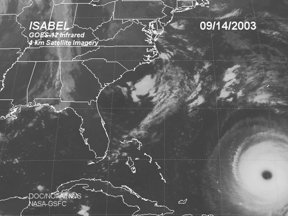
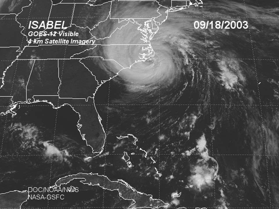
2003 Tropical Storms & Hurricanes Affecting the United States: A Satellite and Radar Study Donovan Landreneau, Forecaster WFO Lake Charles, LA Southern Region Marine Conference March 17, 2004 Satellite (4 & 8 km infrared, **water vapor, visible) and radar (U.S. Mosaic, local 250 & 125nm WSR-88D) of *Bill, *Claudette, *TD7, Erika, Grace, Henri, & Isabel. (* Local 250nm WSR-88D imagery unavailable for Bill, Claudette, & TD7) (** 4 km water vapor imagery unavailable due to poor resolution)
 of *Bill, *Claudette, *TD7, Erika, Grace, Henri, & Isabel. (* Local 250nm WSR-88D imagery unavailable for Bill, Claudette, & TD7) (** 4 km water vapor imagery unavailable due to poor resolution).")
17
Satellite Imagery Donovan Landreneau, Forecaster WFO Lake Charles, LA Southern Region Marine Conference March 17, 2004 Animations consists of 8 km imagery (every ½ hour) of the Eastern United States, and close- up 4 km imagery (every 15 minutes) at 10 frames per second.
 of the Eastern United States, and close- up 4 km imagery (every 15 minutes) at 10 frames per second.")
27
Radar Imagery Donovan Landreneau, Forecaster WFO Lake Charles, LA Southern Region Marine Conference March 17, 2004 Animation consists of national NWS WSR-88D radar reflectivity mosaic, with images every 15 minutes. Followed by local NWS WSR-88D *250 & 125 nautical mile 0.5° reflectivity, with images every 5 to 6 minutes. (* Not available with Bill, Claudette, & TD7)
.")
31
Advantages: Donovan Landreneau, Forecaster WFO Lake Charles, LA Southern Region Marine Conference March 17, 2004 One-stop shop to get radar and/or satellite imagery for an entire season on 1 DVD, which can play on a computer or home DVD player. Most web downloads show animations in one or two day segments, usually requiring high speed internet.

32
Advantages: Donovan Landreneau, Forecaster WFO Lake Charles, LA Southern Region Marine Conference March 17, 2004 In the National Weather Service, AWIPS and WES stations only show 32 frames. One of the seasonal satellite imagery DVDs will have over 8000 frames per satellite channel.

33
Disadvantages: Donovan Landreneau, Forecaster WFO Lake Charles, LA Southern Region Marine Conference March 17, 2004 Being that the imagery is processed MPEG-2 video, you cannot change the color curves (i.e., you cannot go from gray scale to color.) Resolution has to be sized to 640x480 pixels. However, better processing of video has lead to better resolution of larger images.

34
Possible Uses: Donovan Landreneau, Forecaster WFO Lake Charles, LA Southern Region Marine Conference March 17, 2004 Universities for research and teaching tropical meteorology. Can be adapted into short segments of interest for National Weather Service presentations and spotter talks. Television media (local and national).
..")
35
Satellite Imagery Sources: Donovan Landreneau, Forecaster WFO Lake Charles, LA Southern Region Marine Conference March 17, 2004 NESDIS 8 km Eastern U. S. and North Atlantic http://www.goes.noaa.gov/ NASA-GSFC 4 km Eastern U. S. http://rsd.gsfc.nasa.gov/goese/autogvar/

36
Radar Imagery Sources: Donovan Landreneau, Forecaster WFO Lake Charles, LA Southern Region Marine Conference March 17, 2004 National WSR-88D Radar Reflectivity Mosaic http://wwwghrc.msfc.nasa.gov/ims/browse/surface/radar-reflect/gif-inst48/ 7 day 250nm archive http://www.srh.noaa.gov/data/radar/archive_long/ 7 day 125nm archive http://www.srh.noaa.gov/data/radar/archive/

37
Catalog information: Donovan Landreneau, Forecaster WFO Lake Charles, LA Southern Region Marine Conference March 17, 2004 http://www.srh.noaa.gov/lch/tropical/dvd.htm

Similar presentations


 J. Kelly, Jr. National Weather Service Infusion of Satellite.>")


 Enhancements.>")


 theater this is done at 24 frames per second (fps). On TV (NTSC) this is done.>")