Download presentation
Presentation is loading. Please wait.

1
Accounting for ecosystems & biodiversity at the EEA Jean-Louis Weber Environmental accounting / Spatial analysis

2
CORE LAND COVER ACCOUNT Soil Flora & Fauna Water system Atmosphere/ Climate Land use economic & social functions Artificiality of land Intensity of use LAND USE ACCOUNTS Ecosystem services Ecosystem potentials Integrity, health & viability Vulnerability ECOSYSTEM ACCOUNTS Production & Consumption Natural Assets Population Infrastructures & Technologies Land use and ecosystem accounting

3
Ecosystem accounts framework Stocks of ecosystems oDefined in first instance from CLC & rivers e-map oAdditional features/ details can be overlaid to the CLC map or integrated in accounts on a statistical basis Ecosystem health (next slide) oDiagnosis assessment (distress syndrome) (next slide) Ecosystem wealth oIn physical terms as Stock x Health/Distress coefficient Natural capital accounts oMarketed as well as non marketed ecosystem assets oEcosystem goods and services oPhysical units and € Stress on ecosystems (generally, combination of several pressures): oMapped at the scale of land use accounts
 oDiagnosis assessment (distress syndrome) (next slide) Ecosystem wealth oIn physical terms as Stock x Health/Distress coefficient Natural capital accounts oMarketed as well as non marketed ecosystem assets oEcosystem goods and services oPhysical units and € Stress on ecosystems (generally, combination of several pressures): oMapped at the scale of land use accounts")
4
Ecosystem distress diagnosis Stability of substrate oConnectivity / Partitioning oInternal fragmentation, patch structure oAccumulation of toxic substances oVariability/ Instability of Water Systems… Nutrient cycling oChange in primary productivity oChange in secondary productivity oExceedance of nutrient loads oEutrophication… Species dynamics and composition oSpecific oMigratory oIntroduced or invasive oEndangered

5
Ecosystem accounts are established for Individual ecosystems and ecosystem types e.g. “salt marshes of West Mediterranean” or "wetlands“… Geographical systems such as ecozones, eco- complexes, ecological corridors, (small) river basins... e.g. the Danube Delta Management units such as designated areas for nature conservation, river basins, programme areas, regions… e.g. Natura 2000 sites, Ramsar sites, River basin districts…
 river basins... e.g. the Danube Delta Management units such as designated areas for nature conservation, river basins, programme areas, regions… e.g. Natura 2000 sites, Ramsar sites, River basin districts….")
6
Implementation: Individual v.s. geo-statistical monitoring/ accounting WETLANDS 1990 OF N-W EUROPE EEA/ETCTE (courtesy Danube Delta National Institute)
.")
7
* Ecosystem accounts and DPSIR

8
Starting from LAND COVER accounts based on CLC …measure stocks as well as change due to gains and losses (flows) Land cover account, Comunidad de Madrid, 1990-2000 Source: Corine land cover 1990-2000 Land COVER accounts are implemented at the EEA from CLC2000 …are made of Land Cover Accounts Land Use Accounts Ecosystem Accounts
 Land cover account, Comunidad de Madrid, Source: Corine land cover Land COVER accounts are implemented at the EEA from CLC2000 …are made of Land Cover Accounts Land Use Accounts Ecosystem Accounts")
9
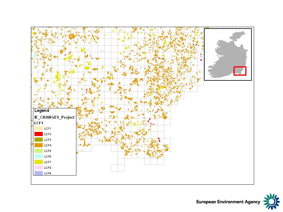
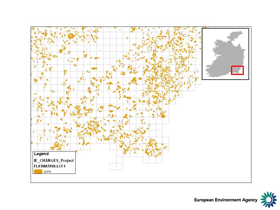
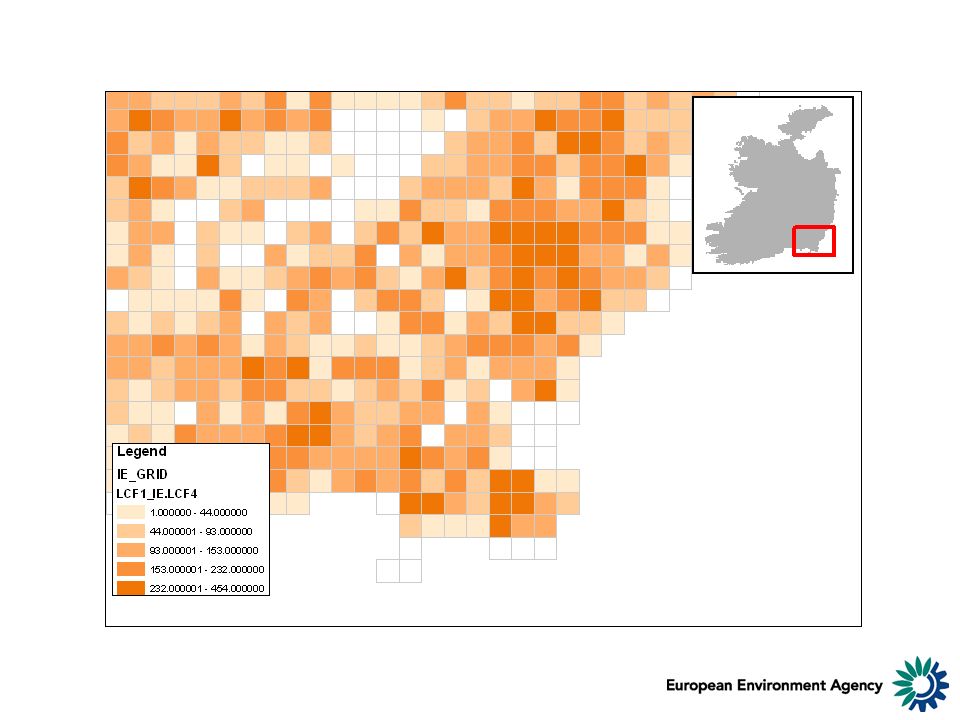
Land cover accounts: from maps to statistics LCF1Urban land management LCF2Urban residential sprawl LCF3Sprawl of economic sites and infrastructures LCF4Agriculture internal conversions LCF5Conversion from other land cover to agriculture LCF6Withdrawal of farming LCF7Forests creation and management LCF8Water bodies creation and management LCF9Changes due to natural & multiple causes Land cover 1990 & 2000 and land cover change are first converted to a grid (below, 3x3 km) Individual changes are grouped by land cover flows that describe processes
 Individual changes are grouped by land cover flows that describe processes")
14
normalized

15
…and back to maps: e.g. Urban sprawl in the province of Venice, 1990-2000 Despite possible threats from sea level rise and the permanent ecological problems of the lagoon due to agriculture eutrophicating surpluses, urban and infrastructures development has continued in the province of Venice. Source: EEA, Land accounts/CLC1990-2000

16
Missing data by Nov. 2004 Differentiation of landscape, agriculture NW Europe & New member countries Intensification: conversions pasture to arable Fast agriculture restructuring Delayed process ? Landscape Natural Potential Important conversions arable to pasture & withdrawal of farming

17
Land & Ecosystem Accounts: need Spatial Integration of Environmental & Socio-Economic Data Collection Mapping Sampling Socio- Economic Statistics Individual Sites Monitoring

18
Integrated land cover, land use and ecosystem monitoring & accounting – a nested approach T T+10 1/100 000 Corine Land Cover (EU/Countries, Regions, Basins, Ecological corridors) 1/500 000 (LC main trends, Vegetation & Humidity + Pan-European, Global …) Fauna, Flora, Physico-Chemical parameters Socio- Economic Statistics In situ monitoring Fauna, Flora, Physico-Chemical parameters Socio- Economic Statistics 1/25 or 10 000 (Cities, Natura2000 sites, coastal zones, risk areas)
 1/ (LC main trends, Vegetation & Humidity + Pan-European, Global …) Fauna, Flora, Physico-Chemical parameters Socio- Economic Statistics In situ monitoring Fauna, Flora, Physico-Chemical parameters Socio- Economic Statistics 1/25 or (Cities, Natura2000 sites, coastal zones, risk areas)")
19
Corine land cover as a common reference CLC2000 (more to come…)
")
20
Main features observed by CLC 1Artificial areas 2AArable land & permanent crops 2BPastures & mosaics 2B1Pastures 2B2Mosaic farmland 3AForested land 3A1Standing forests 3A2Transitional woodland & shrub 3BSemi-natural vegetation 3COpen spaces/ bare soils 4Wetlands 5Water bodies

21
Pan-European scale: to-day: GLC2000

22
Pan-European scale: next (2007): Globcover
: Globcover")
23
To-morrow: joint meeting on spatial analysis, connectivity, fragmentation Selection: All classes with pasture (clc 231, 242, 243, 244) + Forests & dry semi- natural land + Wetlands & water bodies
 + Forests & dry semi- natural land + Wetlands & water bodies")
Similar presentations


 Markus Erhard.>")


