Download presentation
Presentation is loading. Please wait.

1
Michael Coniglio NSSL Stacey Hitchcock CSU Kent Knopfmeier CIMMS/NSSL 10/20/2015 IMPACT OF ASSIMILATING MPEX MOBILE UPSONDE OBSERVATIONS ON SHORT- TERM MODEL FORECASTS OF CONVECTION

2
release of upsondes from 3 – 4 mobile systems over the Plains in afternoon/evening Release of dozens of dropsondes over Intermountain West in early morning & 15 May to 15 June 2013 Do supplemental radiosonde observations taken: 1.upstream and prior to convection, and 2.within the storm-modified environment improve regional NWP model forecast skill? THIS STUDY: 0 – 9 h forecasts release of upsondes from 3 to 4 mobile systems over the Plains in afternoon/evening

3
NWP MODEL FRAMEWORK 1 h ~4 - 5 h before CI Assimilation (WRF-DART EnKF) of METAR, marine, ACARS, raobs & sat winds GEFS IC/LBCs 00z 36 member =15 km =3 km 30 min 9 h forecast on 3-km grid, all 36 members (control) Above obs plus mesonet ~1 - 2 h before CI MPEX upsondes 9 h forecast on 3-km grid, all 36 members (MPEX) ~4 - 5 h before CI
 of METAR, marine, ACARS, raobs & sat winds GEFS IC/LBCs 00z 36 member =15 km =3 km 30 min 9 h forecast on 3-km grid, all 36 members (control) Above obs plus mesonet ~1 - 2 h before CI MPEX upsondes 9 h forecast on 3-km grid, all 36 members (MPEX) ~4 - 5 h before CI")
4
DateRegionStorm Type# pre storm (> 1 h before CI) May 18Western KSTornadic supercells5 May 19Central OKTornadic supercells3 May 20Central OKTornadic to non-tornadic supercell3 May 23Western TXTornadic supercell to MCS4 May 27Central KSTornadic and a weak supercell5 May 28Central KSTornadic supercell and MCS5 May 31Central OKTornadic supercell to MCS3 June 4TX panhandleDryline, no storms15 June 8SW KS/NW OK/TXSquall line w/embedded supercells3 June 11NebraskaWeak storms, then supercell late10 June 12SE WyomingUpslope flow, no storms15 Requirement: At least three soundings > 1 h before CI
 May 18Western KSTornadic supercells5 May 19Central OKTornadic supercells3 May 20Central OKTornadic to non-tornadic supercell3 May 23Western TXTornadic supercell to MCS4 May 27Central KSTornadic and a weak supercell5 May 28Central KSTornadic supercell and MCS5 May 31Central OKTornadic supercell to MCS3 June 4TX panhandleDryline, no storms15 June 8SW KS/NW OK/TXSquall line w/embedded supercells3 June 11NebraskaWeak storms, then supercell late10 June 12SE WyomingUpslope flow, no storms15 Requirement: At least three soundings > 1 h before CI")
5
Three cases not analyzed further since null cases and both control and MPEX experiments were “correct” nulls. DateRegionStorm Type# pre storm (> 1 h before CI) May 18Western KSTornadic supercells5 May 19Central OKTornadic supercells3 May 20Central OKTornadic to non-tornadic supercell3 May 23Western TXTornadic supercell to MCS4 May 27Central KSTornadic and a weak supercell5 May 28Central KSTornadic supercell and MCS5 May 31Central OKTornadic supercell to MCS3 June 4TX panhandleDryline, no storms15 June 8SW KS/NW OK/TXSquall line w/embedded supercells3 June 11NebraskaWeak storms, then supercell late10 June 12SE WyomingUpslope flow, no storms15 Leaves 8 cases to analyze in detail.
 May 18Western KSTornadic supercells5 May 19Central OKTornadic supercells3 May 20Central OKTornadic to non-tornadic supercell3 May 23Western TXTornadic supercell to MCS4 May 27Central KSTornadic and a weak supercell5 May 28Central KSTornadic supercell and MCS5 May 31Central OKTornadic supercell to MCS3 June 4TX panhandleDryline, no storms15 June 8SW KS/NW OK/TXSquall line w/embedded supercells3 June 11NebraskaWeak storms, then supercell late10 June 12SE WyomingUpslope flow, no storms15 Leaves 8 cases to analyze in detail..")
6
31 May 2013 1920 UTC 1801 UTC 1610 UTC

7
31 May 2013 valid 2130 UTC (90 min forecast) : Probability sim. reflectivity ≥ 40 dBZ in 25 x 25 km boxes MPEX control MPEX - control : Observed reflectivity ≥ 40 dBZ

8
31 May 2013 valid 2215 UTC (135 min forecast) : Probability sim. reflectivity ≥ 40 dBZ in 25 x 25 km boxes MPEX control MPEX - control : Observed reflectivity ≥ 40 dBZ

9
MPEX - control Analysis valid 2000 UTC on 15 km grid Difference in mid-level relative humidity (%) Difference in low level divergence (10 -5 s -1 )
 Difference in low level divergence (10 -5 s -1 )")
10
31 May 2013 valid 2330 UTC (210 min forecast) : Probability sim. reflectivity ≥ 40 dBZ in 20 x 20 km boxes MPEX control MPEX - control : Observed reflectivity ≥ 40 dBZ

11
Fractions Skill Score (FSS) 40 dBZ, ~25 x 25 km boxes Forecast hour (min) FSS 31 May
 40 dBZ, ~25 x 25 km boxes Forecast hour (min) FSS 31 May")
12
Forecast hour (min) FSS F = 180 min MPEX - control OFB x x x x MPEX raobs 23 May Fractions Skill Score (FSS) 40 dBZ, ~25 x 25 km boxes
 FSS F = 180 min MPEX - control OFB x x x x MPEX raobs 23 May Fractions Skill Score (FSS) 40 dBZ, ~25 x 25 km boxes")
13
Forecast hour (min) FSS F = 150 min MPEX - control x x x x MPEX raobs 28 May Fractions Skill Score (FSS) 40 dBZ, ~25 x 25 km boxes
 FSS F = 150 min MPEX - control x x x x MPEX raobs 28 May Fractions Skill Score (FSS) 40 dBZ, ~25 x 25 km boxes")
14
Forecast hour (min) FSS F = 180 min MPEX - control x x x x x MPEX raobs 27 May Fractions Skill Score (FSS) 40 dBZ, ~25 x 25 km boxes
 FSS F = 180 min MPEX - control x x x x x MPEX raobs 27 May Fractions Skill Score (FSS) 40 dBZ, ~25 x 25 km boxes")
17
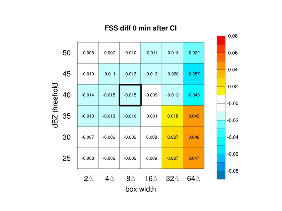
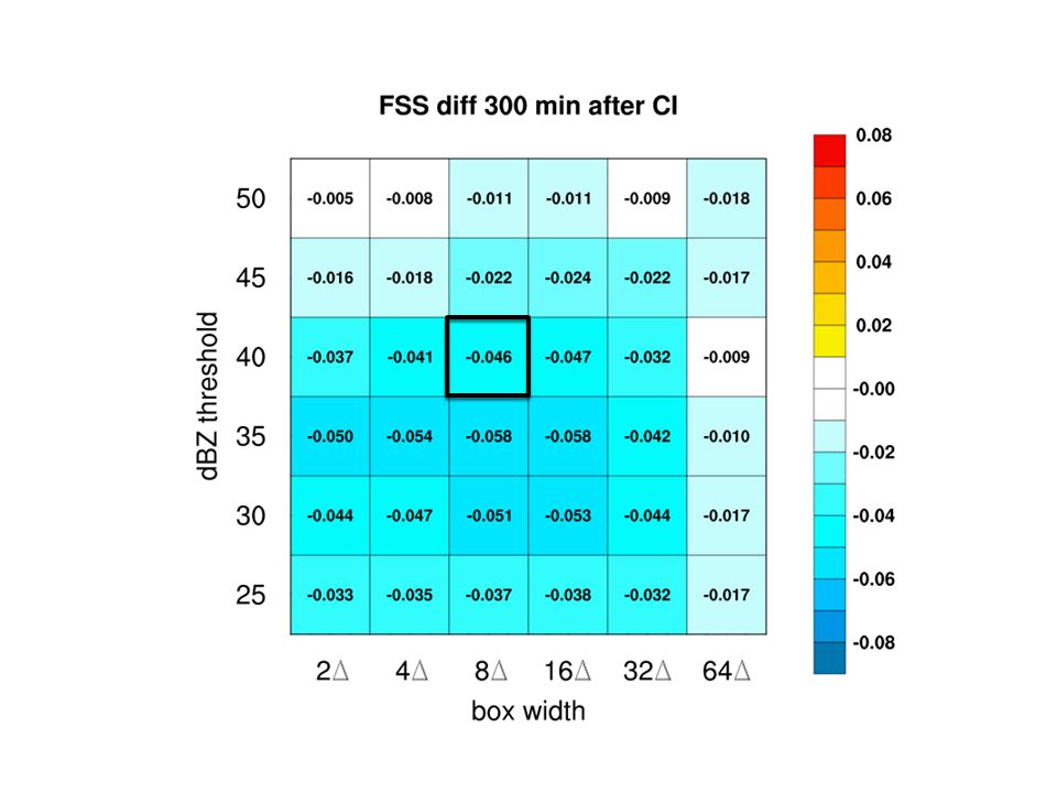
MPEX soundings impact on smallest resolved scales (5-10 x grid spacing) highly variable, maybe neg. overall after ~4 hours Mostly positive impact on mesoscale (16-32 x grid spacing) overall in the first 2 – 3 hours Could improve mesoscale background for full radar DA-type systems (NSSL WoF…next talk) Future: In 2016, use NCAR real-time ensemble to derive quantitative ensemble sensitivity fields to aid in obs targeting decisions (not done for upsondes in MPEX) Compare impacts of radiosondes and AERI remotely-sensed profiles of T/Td in DA experiments....could this be feasible for routine operations? SUMMARY AND THOUGHTS
 overall in the first 2 – 3 hours Could improve mesoscale background for full radar DA-type systems (NSSL WoF…next talk) Future: In 2016, use NCAR real-time ensemble to derive quantitative ensemble sensitivity fields to aid in obs targeting decisions (not done for upsondes in MPEX) Compare impacts of radiosondes and AERI remotely-sensed profiles of T/Td in DA experiments....could this be feasible for routine operations. SUMMARY AND THOUGHTS.")
19
Fractions Skill Score (FSS) 40 dBZ, ~25 x 25 km boxes Forecast hour (min) FSS Aggregated over 8 cases
 40 dBZ, ~25 x 25 km boxes Forecast hour (min) FSS Aggregated over 8 cases")
20
Fractions Skill Score (FSS) 30 dBZ, ~100 x 100 km boxes Forecast hour (min) FSS Aggregated over 8 cases
 30 dBZ, ~100 x 100 km boxes Forecast hour (min) FSS Aggregated over 8 cases")
21
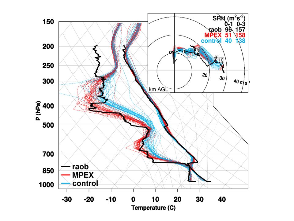
60 min forecasts upstream of Smith Center, KS tornadic supercell

22
31 May 2013 Valid 0300 UTC (420 min forecast) : Probability sim. reflectivity ≥ 40 dBZ in 20 x 20 km boxes MPEX control MPEX - control : Observed reflectivity ≥ 40 dBZ

Similar presentations


 Chris Davis (NCAR ESSL/MMM and RAL) Stan Trier (NCAR ESSL/MMM) Boulder, Colorado 60-h Radar Composite Animation (00.>")


 Real-Time High-Resolution Forecast Using Bluesky Wei Wang May 19, 2005 CISL User.>")

