Download presentation
Presentation is loading. Please wait.

1
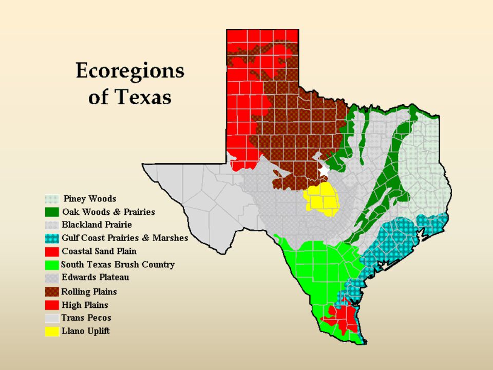
Ecoregions of Texas

2
What Is An Ecoregion? Ecoregion- a major area with distinctive landforms, characteristic plants and animals, and receives uniform solar radiation and precipitation Smaller than a biome

3
Where Are They? Region 1: Pineywoods
Region 2: Cross Timbers or Oak Woods and Prairies Region 3: Blackland Prairies Region 4: Gulf Coast Prairies and Marshes Region 5: Coastal Sand Plains Region 6: South Texas Brush Country

4
Where Are They? Region 6: South Texas Brush Country
Region 7: Edwards Plateau Region 8: Llano Uplift Region 9: Rolling Plains Region 10: High Plains Region 11: Trans Pecos

6
Region 1 Piney Woods Climate: average annual rainfall of inches is fairly uniformly distributed throughout the year, and humidity and temperatures are typically high Soil: generally acidic Geography: rolling terrain Vegetation: pine and oak tall hardwood forests, timber and cattle production are important industries, swamps are common in southern part

7
Piney Woods Caddo Lake Athens Tyler Palestine Rusk

8
Cross Timbers or Oak Woods & Prairies
Region 2 Cross Timbers or Oak Woods & Prairies Climate: Average annual rainfall averages inches per year Soil: Upland soils are light colored, acidic sandy loam or sands. Bottomland soils may be light brown to dark gray and acidic with textures ranging from sandy loams to clays Geography: gently rolling to hilly terrain Vegetation: patches of oak woodland alternate with grassland, cattle ranching is major industry

9
Region 3 Blackland Prairies
Climate: average annual rainfall ranges from inches. May is the peak rainfall month for the northern end of the region; however, the south-central part has a fairly uniform rainfall throughout the year. Soil: soils are uniformly dark-colored alkaline clays Geography: gently rolling to nearly level terrain Vegetation: Rich fertile soils produce food and forage crops, crop production and cattle ranching are main industries

10
Oak Woods, Prairies & Blackland Prairies
Waco, Dallas, Lake Dallas, Killeen, College Station, Huntsville

11
Gulf Coast Prairies and Marshes
Region 4 Gulf Coast Prairies and Marshes Climate: annual rainfall varies from inches per year, high humidity and warm temperatures Soil: acidic sands and sandy loams, with clays occurring in the river bottoms Geography: barrier islands along the coast, marshes near bays and estuaries, and prairies Vegetation: salt grass, tallgrass prairies, live oak woodlands, important habitat for migratory birds and spawning areas for fish and shrimp

12
Region 5 Coastal Sand Plains
Climate: Average annual rainfall is inches per year Soil: primarily windblown Geography: windblown sands and unstable dunes with grasslands, stands of oak, and salt marshes Vegetation: tallgrass prairie with live oak woodlands, mesquite savannah, and salt marshes, formerly known as “Wild Horse Prairie” now it is mostly grazed by cattle

13
Gulf Coast Prairies and Marshes
Padre Island Brownsville Houston Corpus Christi Galveston

14
South Texas Brush Country
Region 6 South Texas Brush Country Climate: average annual rainfall of inches increases from west to east. Summer temperatures are high, with very high evaporation rates Geography: flat plains to gently rolling terrain Vegetation: thorny shrubs, trees, and cactus scattered with patches of palms and subtropical woodlands, home to many species of wildlife from Mexico to grasslands and deserts

15
South Texas Brush Country
Laredo, San Antonio

16
Region 7 Edwards Plateau
Climate: average annual rainfall ranges from inches Soil: usually shallow with a variety of surface textures, underlain by limestone Geography: many springs, stony hills, and steep canyons and caves; several river systems dissect the surface, creating a rough and well-drained landscape Vegetation: grasslands, juniper/oak woodlands, and plateau live oak or mesquite savannah, ranching is main industry

17
Region 8 Llano Uplift Climate: averages about 24-32 inches per year
Soil: coarse textured sands, produced from weathered granite over thousands of years Geography: some of the oldest rocks in Texas, the region contains unique minerals and rock formations and large granite domes( Enchanted Rock near Fredricksburg); hilly to rolling landscape Vegetation: oak-hickory or oak-juniper woodlands, mesquite-mixed brush savannah, and grasslands
; hilly to rolling landscape. Vegetation: oak-hickory or oak-juniper woodlands, mesquite-mixed brush savannah, and grasslands.")
18
Edwards Plateau Llano Uplift
Austin Bastrop San Marcos Round-Rock

19
Region 9 Rolling Plains Climate: average annual rainfall is inches; dry summers with high temperatures and high evaporation rates Soil: vary from coarse sands along outwash terraces by streams, to clays and shales Geography: gently rolling hills and broad flats are cut by several rivers and their tributaries Vegetation: mesquite and shortgrass savannah; various hardwood species along streams, juniper on steep slopes along rivers

20
Region 10 High Plains Climate: extended droughts have occurred several times this century Soil: surface texture of soils ranges from clays in the north to sands in the south; Caliche underlies these surface soils at depths of two to five feet Elevation: ranges from 3,000-4,500 feet above sea level Geography: relatively level high plateau Vegetation: mostly irrigated cropland; native vegetation includes mesquite and juniper

21
Panhandle Plains Amarillo, Wichita Falls, Lubbock, Abilene

22
Region 11 Trans Pecos Climate: Less than 12 inches of rain; semi-arid, warm, dry winters Soil: generally shallow, saline, and unproductive Elevation: 2,500 feet to mountain ranges, highest peak is 8,751 feet above sea level Geography: salt basins, sand hills, rugged plateaus, mountain slopes Vegetation: desert grassland, desert scrub, coniferous and mixed hardwood forests at mountain peaks

23
Trans Pecos El Paso, Midland, Odessa

24
My Ecoregion Which region do you live in?
Have you ever visited another region?

Similar presentations