Download presentation
Presentation is loading. Please wait.

1
Geography of East Africa
The Great Rift Valley And The Horn of Africa

2
Identify the area people mean when they say the “Horn of Africa.”
Objectives What divides Africa into two major areas? Who lives to the north and who lives to the south of this great divider? Identify the area people mean when they say the “Horn of Africa.” Describe the rift valley of East Africa. Identify the Savannah

3
Rift valleys form when tectonic plates pull apart.
Terms and People Rift valleys form when tectonic plates pull apart. Savannah is an open grassland with scattered trees. The Horn of Africa is a sharply pointed peninsula on Africa’s east. Swahili is an east African language. Heritage is Where are the major savannah areas of Africa?

4
Terms and People Subsistence faming is A cash crop is Economy is
Diversify is

6
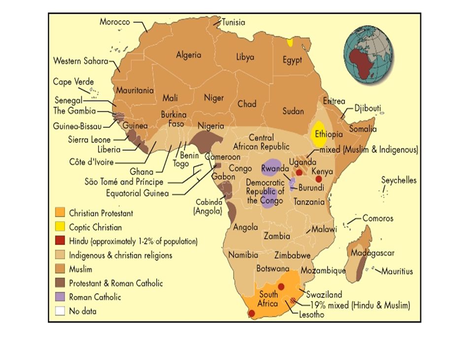
The Sahara Desert divides Africa into two ethnic areas.
North of the Sahara live Arabs and Berbers. The Sahara Desert The Sahara Desert is difficult to cross and has divided people for thousands of years. South of the Sahara live many different peoples.

7
Sahara Desert Rift Valleys

9
A great crack in the Earth’s plates runs down Africa’s east side.
This crack forms the Great Rift Valley. The bottom of this valley often has good land. Most of Africa’s active volcanoes are along the Great Rift Valley. A rift forms when plates move away from each other.

14
Poverty continues to plague Sub-Saharan Africa.

15
The Congo Basin has a low population.
The Sahara Desert has almost no population. After West Africa, East Africa has the densest population. Nigeria Ethiopia The Congo Basin has a low population. The Lakes South Africa

18
Traditional trade in West Africa traveled across the desert to North African Arabs and Berbers.
Traditional trade in East Africa traveled by sea along the coast to Arabia and India.

20
What landform divides Africa into two major ethnic regions?
Which religion believes that trees, rocks, and bodies of water have spirits of their own? The Niger River The Sahara Desert Animism The rainforest The Nile Delta Who lives to the north of the Sahara Desert? What is the name of the geographical feature in which water flows downward and inward? Arabs and Berbers A rift valley What great religious change began 500 years ago and is still occurring in Africa? A basin A delta A savannah Islam is driving out animism. Animism is driving out Christianity. Christianity is driving out Islam. Animism is driving out Buddhism.

21
Around what geographical feature did most of Sub-Saharan Africa’s early civilizations develop ?
What is the name of the geographical feature in which the Earth’s plates pull away from each other? The Niger River A rift valley The Sahara Desert A mountain The Great Rift Valley A volcano The central rainforests A savannah What large land feature makes living and travel difficult in central Africa? The Great Rift Valley The Congo Basin The Nile Delta The Great African Savannah

Similar presentations