Download presentation
Presentation is loading. Please wait.

1
ANNUAL TROPICAL CYCLONE, DISASTER PREPAREDNESS & CLIMATE WORKSHOP
GUAM Chip Guard Warning Coordination Meteorologist Weather Forecast Office Guam

2
Purpose of the Workshop
Familiarize you with tropical cyclone hazards, characteristics, and behavior Familiarize you with the tropical cyclone program and products for Guam Discuss typhoon risks & vulnerabilities for Guam Familiarize you with causes of weather around Guam Familiarize you with other weather and ocean hazards, including rip currents, tsunamis, volcanoes Familiarize you with Guam’s climate Provide an opportunity for you to ask questions on weather- or climate-related topics

3
Tropical Cyclone Topics
Tropical Cyclone Characteristics, Behavior and Hazards NWS Tropical Cyclone Program NWS Tropical Cyclone Products Timing of Products

4
Tropical Cyclone Characteristics
Tropical Cyclone Structure and Behavior Hazards Associated with a Tropical Cyclone—The Triple Threat

5
What Is A Tropical Cyclone?
It’s a large area of clouds with a warm core low pressure center, which usually forms over tropical waters and has an organized circulation. It is like a pancake!

6
Stages of Tropical Cyclones
TROPICAL CYCLONE...a general term that includes tropical depressions, tropical storms, typhoons and super typhoons TROPICAL DEPRESSION...a tropical cyclone with maximum sustained winds of 38 mph or less TROPICAL STORM...a tropical cyclone with maximum sustained winds within the range 39 to 73 mph TYPHOON...a tropical cyclone with maximum sustained winds of 74 mph or greater SUPER TYPHOON...a typhoon with maximum sustained winds of 150 mph or greater

7
Different Stages of Tropical Cyclone Development

8
Different Shapes and Sizes of Tropical Cyclones

9
Necessary Ingredients
a pre-existing disturbance warm ocean water...temperature at least 80 degrees F down to a depth of 150 ft light upper level winds...little or no wind shear

10
Typhoon Structure

11
Typhoon Structure

12
THE TRIPLE THREAT Winds Storm surge and surf
Heavy rain producing floods and mudslides

13
Winds: Sustained and Gusts
wind dir 07 11 15 19 23 03 85(100) 70(80) 50(60) 35(40) 17(20) 0(0) 105(120) ktmph 29.770 29.495 29.220 28.945 28.670 28.395 28.120 stn pres direction pressure speed
 70(80) 50(60) 35(40) 17(20) 0(0) 105(120) ktmph stn pres. direction. pressure. speed.")
14
Tropical Cyclone Winds
150 feet Few People Live Here 700 feet-- Most People Live Here 15 feet----- Most tourists stay here

15
Types of Wind Damage

16
Types of Wind Damage

17
Wind Damage

18
Wind Asymmetry Associated With Tropical Cyclones
“Right side of the storm" is defined with respect to the storm's motion: if the cyclone is moving to the west, the right side would be to the north of the storm; if the cyclone is moving to the north, the right side would be to the east of the storm, etc. In general, the strongest winds are found on the right side of the cyclone because the motion of the cyclone also contributes to its swirling winds.

19
Wind Intensity and Distribution in a Tropical Cyclone
Strongest winds are located in right quadrant because of effect of speed of movement is added to wind distribution. (Likewise, winds are weaker in left quadrant because effect of the speed of movement is subtracted from the wind field. ) Therefore, if cyclone passes south or west of island, then winds may be stronger than forecast. Or, if a cyclone passes north or east of island, then winds may be weaker than forecast.
 Therefore, if cyclone passes south or west of island, then winds may be stronger than forecast. Or, if a cyclone passes north or east of island, then winds may be weaker than forecast.")
20
Tropical Cyclone Wind Asymmetries
100 MPH 60 MPH 75 MPH 125 MPH (a) (b) (d) (c)
 (b) (d) (c)")
21
Wind Direction if a TC Passes North or East or North of Your Island
Bay Ballot’s Law: Face into wind and low pressure is to your right (in the northern hemisphere) If winds are from the NE, the TC is SE of island If winds are from the N, the TC is E of island If winds are from the NW, the TC is NE of island If winds are from the W, the TC is N of island If winds are from the SW, the TC is NW of island
 If winds are from the NE, the TC is SE of island. If winds are from the N, the TC is E of island. If winds are from the NW, the TC is NE of island. If winds are from the W, the TC is N of island. If winds are from the SW, the TC is NW of island.")
22
Wind Direction if a TC Passes South or West of Your Island
Bay Ballot’s Law: Face into wind and low pressure is to your right (in the northern hemisphere) If winds are from the NE, the TC is SE of island If winds are from the E, the TC is S of island If winds are from the SE, the TC is SW of island If winds are from the S, the TC is W of island If winds are from the SW, the TC is NW of island
 If winds are from the NE, the TC is SE of island. If winds are from the E, the TC is S of island. If winds are from the SE, the TC is SW of island. If winds are from the S, the TC is W of island. If winds are from the SW, the TC is NW of island.")
23
HIGH SEAS—Small Craft Stay in Port!!!! Inter-Island Travel is Dangerous!!!!
Guam

24
STORM SURGE Storm surge is the increase is sea height above the normal tide level, caused by the tropical cyclone’s low pressure and strong winds. Low pressure component ft elevation per 50 mb drop in pressure Wind component…strong winds cause water to pile up in the right front quadrant. Inundation is the water that penetrates into normally dry land. Depends on speed and duration of the wind; TC size, speed of motion; shape of coast, slope of bottom, width of the reef; and tidal state (high or low) are all important. The storm surge plus the tide is the storm tide.
 are all important. The storm surge plus the tide is the storm tide.")
25
Storm Surge: Affects of Reefs

26
Storm Surge

27
Surf and Storm Surge

28
Heavy Rainfall Rainfall produced by cyclones can be highly variable
Amounts depend on the size of the storm, the speed at which it is moving, and the location of its rain bands Typically 6 to 12 inches of rain can fall as a storm passes Rain rates can be 6+ inches per hour, 20+ inches total Coastal flooding will occur when the ocean level is elevated and rain cannot flow back to the sea Flash flooding many occur as streams and rivers overflow Mudslides may result due to saturated soils and wind stress on trees and foliage

29
Heavy Rainfall Producing Floods and Flash Floods
Heavy rains are rapidly directed to the base of the mountain causing flash floods Elevated sea levels prevent rains from draining to the sea causing coastal flooding

30
Heavy Rainfall Contributes to Coastal Flooding and Inland Flooding

31
Heavy Rainfall Producing Mudslides

32
Heavy Rainfall Producing Mudslides
Estimated Critical Parameters ~ 15” rain falls in 36 hours continued 1” per hour rain We Will Issue a Special Weather Statement for Mudslides When: ~ 10” rain falls in 36 hours or less rainfall greater than 0.50” per hour is expected to continue

33
Heavy Rainfall Producing Mudslides

34
Heavy Rainfall Producing Mudslides

35
Heavy Rainfall Producing Mudslides

36
Heavy Rainfall Producing Mudslides
Most Vulnerable Areas where a slide occurred before, but bedrock is not exposed the steeper areas made of clay where vegetation has been removed

37
How Do Tropical Cyclones Get Named?
JTWC used to name them Now the World Meteorological Organization names them through the Japan Meteorological Agency Five lists of names taken from 12 countries Does anyone know the Chamorro names?

38
How Do Tropical Cyclones Get Named?
Does anyone know the Chamorro names? Roke, Francisco, Maria, Vicente

39
Break Time

40
WEATHER FORECAST OFFICE (WFO) GUAM’S TROPICAL CYCLONE PROGRAM FOR GUAM
 GUAM’S TROPICAL CYCLONE PROGRAM FOR GUAM")
41
Weather Forecast Office Guam

42
Guam’s Area of Responsibility

43
WFO Guam Tropical Cyclone Warning Points

44
TROPICAL CYCLONE PROGRAM
Tropical cyclone watch and warning procedures Tropical cyclone program products/messages Products schedule

45
Warning Process Starts with the Products of the Joint Typhoon Warning Center in Hawaii Weather Service Forecast Office in Guam Analyzes JTWC Products and Issues Watches and Warnings Weather Forecast Office Guam Notifies Guam Civil Defense

46
Warning Process Homeland Security/Office of Civil Defense Works with the Governor’s Office to set CORs

47
Warning Process Civil Defense informs the general public and government agencies, and provides preparedness instructions

48
Joint Typhoon Warning Center (JTWC):
Located at Pearl Harbor, Hawaii; area of responsibility is 110 million square miles Consists of a team of Navy and Air Force meteorologists who use numerous tools to analyze TC location, intensity and wind distribution, and computer models to help predict the future movement JTWC responsible for all US tropical cyclone forecasting in the Northwest Pacific

49
Joint Typhoon Warning Center (JTWC):
Monitors region for developing tropical weather systems—Significant Tropical Weather Advisory Alerts that systems are showing the potential for development into SIGNIFICANT tropical cyclones within the next 12 to 24 hours—Tropical Cyclone Formation Alert Issues track and intensity forecasts for all tropical cyclones (30 mph and stronger) in the region—Tropical Cyclone Warnings
 in the region—Tropical Cyclone Warnings.")
50
NWS WFO Guam: Monitors Area of Responsibility (AOR) for weather systems showing signs of developing into tropical cyclones—Satellite Interpretation Message. Maintains direct communications with JTWC regarding these areas of disturbed weather. Will issue Special Weather Statements to cover areas not yet warned on by JTWC. We may change to a Tropical Disturbance Advisory
 for weather systems showing signs of developing into tropical cyclones—Satellite Interpretation Message. Maintains direct communications with JTWC regarding these areas of disturbed weather. Will issue Special Weather Statements to cover areas not yet warned on by JTWC. We may change to a Tropical Disturbance Advisory.")
51
NWS WFO Guam: Evaluates JTWC warnings for potential effect upon specific islands within the AOR. Based on assessments, WFO Guam sets tropical cyclone watches and warnings, and issues other products. Tropical Cyclone Public Advisories (WTPQ31-35 PGUM) Typhoon Local Statements (WTPQ81-85 PGUM) We watch out for Micronesia and will deviate from the JTWC warnings if we deem it necessary.
 Typhoon Local Statements (WTPQ81-85 PGUM) We watch out for Micronesia and will deviate from the JTWC warnings if we deem it necessary.")
52
TROPICAL CYCLONE WATCH AND WARNING PROCEDURES
DEFINITIONS ISSUING WATCHES AND WARNINGS FOR THE ISLANDS CANCELING WATCHES AND WARNINGS

53
Definitions Damaging Winds: Sustained surface winds of 39 mph or more (averaged over a 1-minute period). Destructive Winds: Sustained surface winds of 60 mph or more (averaged over a 1-minute period). Tropical Storm Watch: An announcement for specific islands that a tropical storm or developing tropical storm (winds 39 to 73 mph inclusive) poses a possible threat generally within 48 hours. Typhoon Watch: An announcement for specific islands that a typhoon or developing typhoon (winds 74 mph or more) poses a possible threat generally within 48 hours.
. Tropical Storm Watch: An announcement for specific islands that a tropical storm or developing tropical storm (winds 39 to 73 mph inclusive) poses a possible threat generally within 48 hours. Typhoon Watch: An announcement for specific islands that a typhoon or developing typhoon (winds 74 mph or more) poses a possible threat generally within 48 hours.")
54
Definitions Tropical Storm Warning: A warning for tropical storm conditions, including 1-minute sustained surface winds within the range of 39 to 73 mph, that are expected at specified islands within 24 hours or are occurring. Typhoon Warning: A warning that typhoon conditions, including 1-minute sustained surface winds of 74 mph or more, are expected at specified islands within 24 hours or are occurring.

55
Issuing Watches and Warnings
The goal of timing the typhoon warning on initiation of 39 mph winds is to provide the people about 24 hours—12 hours of daylight—to complete preparations before weather conditions begin to deteriorate significantly. If we issued the warning 24 hours prior to the expected start of typhoon force winds (74 mph or more), final preparations might not be completed before the arrival of damaging winds, exposing people to dangerous conditions. This could happen with a typhoon that speeds up or rapidly intensifies.
, final preparations might not be completed before the arrival of damaging winds, exposing people to dangerous conditions. This could happen with a typhoon that speeds up or rapidly intensifies.")
56
Issuing Watches and Warnings
Criteria for issuing a Watch: When damaging winds are possible within 48 hours. A Tropical Storm Watch is issued when a JTWC forecast indicates that a tropical cyclone will be at tropical storm intensity when it passes and damaging winds (39 mph or more) are possible within 48 hours. The tropical cyclone may currently be a tropical storm or a tropical depression that is forecast to intensify.
 are possible within 48 hours. The tropical cyclone may currently be a tropical storm or a tropical depression that is forecast to intensify.")
57
Issuing Watches and Warnings
Criteria for issuing a Watch: When damaging winds are possible within 48 hours. A Typhoon Watch is issued when a JTWC forecast indicates that a tropical cyclone will be at typhoon intensity when it passes and damaging winds (39 mph or more) are possible within 48 hours. The tropical cyclone may currently be a typhoon or a tropical storm that is forecast to intensify.
 are possible within 48 hours. The tropical cyclone may currently be a typhoon or a tropical storm that is forecast to intensify.")
58
Issuing Watches and Warnings
Criteria for issuing a Warning: When damaging winds are expected within 24 hours. A Tropical Storm Warning is issued when a JTWC forecast indicates that a tropical cyclone will be at tropical storm intensity when it passes and damaging winds (39 mph to 73 mph) are expected within 24 hours. The tropical cyclone may currently be a tropical storm or a tropical depression that is forecast to intensify.
 are expected within 24 hours. The tropical cyclone may currently be a tropical storm or a tropical depression that is forecast to intensify.")
59
Issuing Watches and Warnings
Criteria for issuing a Warning: When damaging winds are expected within 24 hours. A Typhoon Warning is issued when a JTWC forecast indicates that a tropical cyclone will be at typhoon intensity when it passes and damaging winds (39 mph or more) are expected within 24 hours. The tropical cyclone may currently be a typhoon or a tropical storm that is forecast to intensify into a typhoon.
 are expected within 24 hours. The tropical cyclone may currently be a typhoon or a tropical storm that is forecast to intensify into a typhoon.")
60
Issuing Watches and Warnings
Criteria for issuing a Warning: When damaging winds are expected within 24 hours. Tropical Storm Warning and Typhoon Watch: If the forecast winds are being produced by a typhoon passing at some distance, the pre-existing typhoon watch is also maintained (remains in effect). (Note that the Typhoon Watch indicates that typhoon strength winds are still possible at the location but not currently expected.) Thus, a Tropical Storm Warning and Typhoon Watch may be in effect simultaneously for an island.
. (Note that the Typhoon Watch indicates that typhoon strength winds are still possible at the location but not currently expected.) Thus, a Tropical Storm Warning and Typhoon Watch may be in effect simultaneously for an island.")
61
Canceling Watches and Warnings
WATCHES are canceled when the threat of the tropical storm or typhoon ends, either by moving away or by dissipating WARNINGS are canceled when damaging winds (39 mph) cease and the potential for coastal flooding/inundation by the sea has subsided or when damaging winds are no longer expected. In either case, there is close coordination with HS/OCD.
 cease and the potential for coastal flooding/inundation by the sea has subsided or when damaging winds are no longer expected. In either case, there is close coordination with HS/OCD.")
62
Canceling Watches and Warnings
A typhoon warning will not normally be stepped down to a tropical storm warning as winds diminish to below typhoon intensity at an island. Rather, the typhoon warning will remain in place until winds are less than damaging (below 39 mph), and coastal flooding has ended. A typhoon warning may be downgraded to a tropical storm warning only if a typhoon changes direction or weakens significantly, and typhoon conditions are deemed no longer possible.
, and coastal flooding has ended. A typhoon warning may be downgraded to a tropical storm warning only if a typhoon changes direction or weakens significantly, and typhoon conditions are deemed no longer possible.")
63
Conditions vs. Watch/Warnings Based on onset of damaging winds…
Condition 4: within 72 hours Condition 3: within 48 hours Condition 2: within 24 hours Condition 1: within 12 hours Watch: within 48 hours Warning: within 24 hours

64
Summary Watch indicates damaging winds (39 mph) are possible within 48 hours or less. Types of watches: Tropical Storm (39 to 73 mph) or Typhoon (74 mph or greater); provides an indication of the tropical cyclone’s possible sustained wind threat. Warning indicates damaging winds (39 mph) are expected within 24 hours or less. Types of warnings: Tropical Storm (39 to 73 mph) or Typhoon (74 mph or greater); provides an indication of the expected sustained winds at an island as the tropical cyclone passes.
 or Typhoon (74 mph or greater); provides an indication of the tropical cyclone’s possible sustained wind threat. Warning indicates damaging winds (39 mph) are expected within 24 hours or less. Types of warnings: Tropical Storm (39 to 73 mph) or Typhoon (74 mph or greater); provides an indication of the expected sustained winds at an island as the tropical cyclone passes.")
65
TROPICAL CYCLONE PRODUCTS
JTWC Bulletin Public Advisory Local Statements Position Estimates

66
JTWC Bulletin

67
JTWC Bulletin (cont’d)
")
68
JTWC Warning

69
Tropical Cyclone Public Advisory
Primary source of cyclone information

70
Public Advisory Used to issue and cancel all tropical cyclone watches and warning Provides essential information about tropical cyclone: Location; movement; intensity Gives general forecast information: timing of damaging and typhoon winds, storm surge height, and precipitation amounts Provides general call to action statements/ precautions that the public should take

71
Types of Public Advisories
Standard Public Advisory: Issued every 6 hours (2 pm, 8 pm, 2 am, and 8 am) after receipt of new JTWC warning Used to place an island in under a watch or warning Intermediate Public Advisory Issued between Standard Advisories (11 am, 5 pm, 11 pm, and 5 am) Used to update TC location and track information May be used to clear watches and warnings Special Public Advisory Issued to provide significant TC forecast changes (can be any time except Standard Public Advisory times) May be issued to set new watches or warnings between Standard Advisory times
 after receipt of new JTWC warning. Used to place an island in under a watch or warning. Intermediate Public Advisory. Issued between Standard Advisories (11 am, 5 pm, 11 pm, and 5 am) Used to update TC location and track information. May be used to clear watches and warnings. Special Public Advisory. Issued to provide significant TC forecast changes (can be any time except Standard Public Advisory times) May be issued to set new watches or warnings between Standard Advisory times.")
72
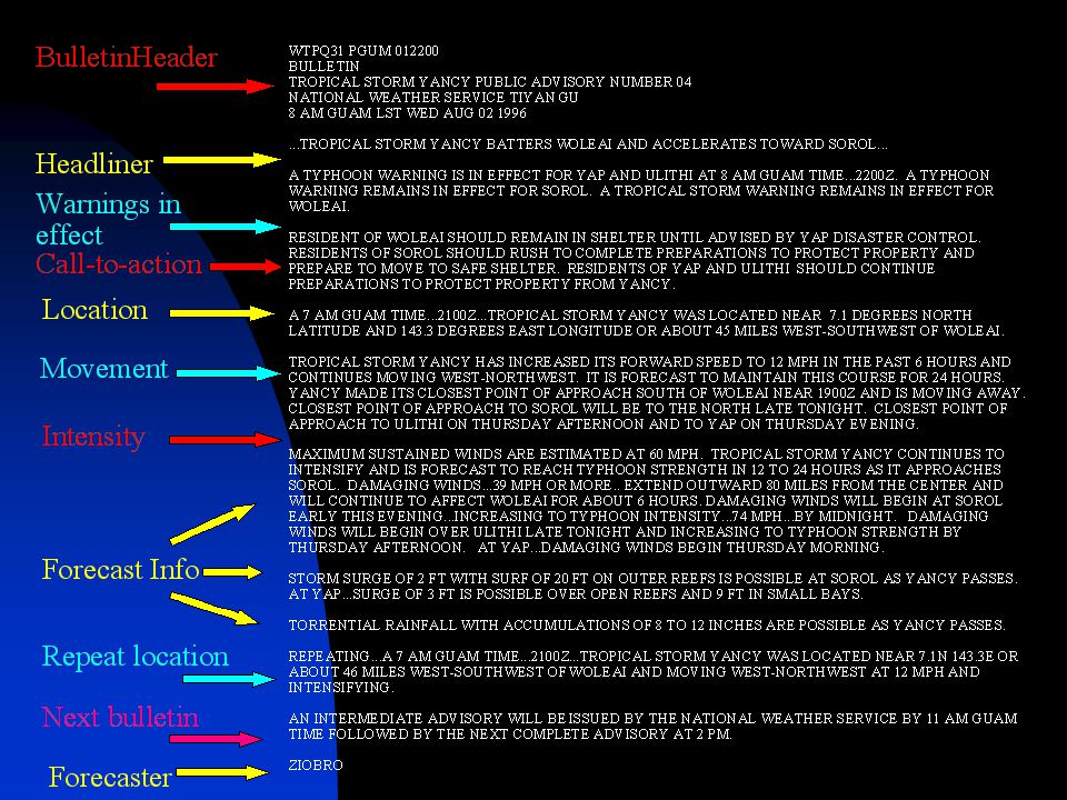
Public Advisory Layout
...HEADLINE... SUMMARY OF WATCHES AND WARNINGS IN EFFECT CALL TO ACTION STATEMENTS LOCATION, MOVEMENT & CURRENT INTENSITY FORECAST INFORMATION NEXT ADVISORY TIME

74
Tropical Cyclone Local Statement
Detailed bulletin containing tropical cyclone information

75
Local Statements Provides detailed local information regarding the expected magnitude and timing of the tropical cyclone’s threat to each affected island Lists all watches and warnings in effect Provides evacuation and other information from OCD Presents storm specific information: location, movement and intensity Wind information: current wind, onset time of damaging and typhoon winds, maximum wind, potential damage from forecast winds, ending times Storm surge, surf, and inundation information Expected precipitation amounts and potential for flooding and mudslides

76
Local Statement Layout
...HEADLINE... WATCHES AND WARNINGS IN EFFECT STORM SPECIFIC INFORMATION FOR INDIVIDUAL ISLANDS: PRECAUTIONARY ACTIONS (EMO PROVIDED COR/EVACUATION INFO) STORM SURGE/SURF INFORMATION WIND INFORMATION PRECIPITATION FORECAST NEXT LOCAL STATEMENT ISSUANCE TIME
 STORM SURGE/SURF INFORMATION. WIND INFORMATION. PRECIPITATION FORECAST. NEXT LOCAL STATEMENT ISSUANCE TIME.")
78
Universal Time Coordinated (UTC) or Zulu (Z) Time
What is UTC or Z time? It is the time at Greenwich, England It is the time on the Zero (0o) Meridian It is 12 hours from the Date Line (180o) Meridian Why use UTC or Zulu time? So we can compare times anywhere in the world. How does Guam/Chamorro time differ from UTC? We are 10 hours ahead. 00 UTC = 10 am; 12 UTC = 10 pm; 14 UTC = 12 am the next day; 20 UTC = 6 am the next day
 Meridian. It is 12 hours from the Date Line (180o) Meridian. Why use UTC or Zulu time So we can compare times anywhere in the world. How does Guam/Chamorro time differ from UTC We are 10 hours ahead. 00 UTC = 10 am; 12 UTC = 10 pm; 14 UTC = 12 am. the next day; 20 UTC = 6 am the next day.")
79
Product Schedule Tropical cyclone warnings are valid at:
00Z (10 am), 06Z (4 pm), 12Z (10 pm), and 18Z (4 am) Tropical cyclone warnings are issued at: 03Z (1 pm), 09Z (7 pm), 15Z (1 am), and 21Z (7 am)
, 06Z (4 pm), 12Z (10 pm), and 18Z (4 am) Tropical cyclone warnings are issued at: 03Z (1 pm), 09Z (7 pm), 15Z (1 am), and 21Z (7 am)")
80
Product Schedule

81
Position Estimates

82
Position Estimates Only issued when tropical cyclone is within radar range (230 miles) and radar info is reliable Short bulletin that updates the center location Lat/long info and as a distance and bearing from one of the Mariana Islands (typically Guam) Updated hourly This position data will be used as the location information in succeeding Public Advisories and Local Statements
 Updated hourly. This position data will be used as the location information in succeeding Public Advisories and Local Statements.")
83
Position Estimates

84
Position Estimates

85
Position Estimates USER BEWARE!
Short term variations may not be indicative of changes in overall motion of the tropical cyclone

86
Product Schedule

87
Product Schedule

88
WFO Guam Office Information
OPERATIONS HOURS: OPEN 24 HOURS IMPORTANT PHONE NUMBERS: Warning Coordination Meteorologist: (671) Guam Duty Forecaster: (671) Guam FAX: (671) Guam HS/OCD (671) WFO GUAM INTERNET ADDRESS: JTWC PRODUCTS:
 Guam Duty Forecaster: (671) Guam FAX: (671) Guam HS/OCD (671) WFO GUAM INTERNET ADDRESS: JTWC PRODUCTS:")
89
Any Questions?

90
Now HS/OSD Will Discuss Its Operations and Coordination

91
LUNCH BREAK

Similar presentations


 C Asia Air Survey co., ltd New Forecast Technologies for Disaster Prevention and Mitigation 1.>")


