Download presentation
Presentation is loading. Please wait.

1
The Role of WIS & WIGOS in supporting WMO Priority Areas
World Meteorological Organization Working together in weather, climate and water WMO The Role of WIS & WIGOS in supporting WMO Priority Areas WIS Implementation Workshop November 1, 2011, SOFIA Dr W. ZHANG, D/OBS WMO

2
WMO Congress 16 decide 5 key priorities for 2012-2015
GFCS Capacity building WIGOS/WIS Disaster Risk Reduction Aeronautical meteorology 2 2

3
The Role of WIS & WIGOS in the five main elements of the GFCS

4
1. WIS Role in GFCS

5
Role of CSIS within the GFCS
The CSIS is the means of delivery of climate data and products. It comprises global, regional and national information centres and entities that generate/process climate information , and the exchange of data and products to agreed standards and protocols. It must be supported by observation and information programmes. Capacity building initiatives will increase ‘conductivity’ of data flow

6
Basic conceptual elements of GFCS --Climate Service Information System(CSIS)
Chapter 2: OBSERVING SYSTEMS AND DATA EXCHANGE: Mechanisms for climate data exchange: A new World Meteorological Organization Information System is being developed to serve as the coordinated global infrastructure for the telecommunication and management of weather, climate, water and related data. The new Information System has been designed to meet global requirements for routine collection and dissemination not only of observed data but also of value-added analysis products. It will also support user needs for locating, accessing and transmitting data.

7
Addressing issues of data exchange and access (HLT report)
The WMO is in the process of implementing an information system (WIS) capable of distributing observations and information globally as well as providing access to the same datasets on user request. This system has global hubs feeding regional nodes and offers the potential to be able to honour the national data policies of all data providers. It is expected that this system will be fully implemented by 2015, with some elements becoming available in The Global Framework for Climate Services should make use of this and other suitable information systems for exchanging data and information.
 capable of distributing observations and information globally as well as providing access to the same datasets on user request. This system has global hubs feeding regional nodes and offers the potential to be able to honour the national data policies of all data providers. It is expected that this system will be fully implemented by 2015, with some elements becoming available in The Global Framework for Climate Services should make use of this and other suitable information systems for exchanging data and information.")
8
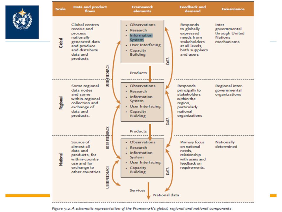
2) Climate Services Information System (CSIS)
This is the system needed to collect, process and distribute climate data and information according to the needs of users as well as to the procedures agreed by governments and other data owners. It should be largely based on, or parallel to, the existing internationally-agreed systems for exchanging and processing meteorological data and information. These communication systems are often tailored to serve particular provider - user communities, although the proposed World Meteorological Organization Information System offers generic functionality well suited to providing access to climate services globally. (Show HLT report Figure 9.2)
")
10
The GFCS and WIS WIS metadata is not limited to describing data and products. => WIS metadata for climate service discovery WIS data communication network can be used by all WMO programms (WWW, DRR, WIS can provide the basic data transport and discovery infrastructure for the GFCS

11
2. WIGOS Role in GFCS

12
The Role of WIS & WIGOS in the five main elements of the GFCS

13
WMO INTEGRATED GLOBAL OBSERVING SYSTEM (WIGOS)
Background: WMO Global Observing Systems Global Observing Systems (WWW/GOS) RBSN, RBCN (>10,000 stations,1,000 upper-air) AMDAR (39754/day) Ship & Marine obs (30417/day) Surface-based remote sensing Meso-scale networks WMO Space Programme Global Atmospheric Watch (GAW) World Hydrological Cycle Observing System (WHYCOS) WMO Co-sponsored Observing Systems GCOS, GOOS, GTOS
 RBSN, RBCN (>10,000 stations,1,000 upper-air) AMDAR (39754/day) Ship & Marine obs (30417/day) Surface-based remote sensing. Meso-scale networks. WMO Space Programme. Global Atmospheric Watch (GAW) World Hydrological Cycle Observing System (WHYCOS) WMO Co-sponsored Observing Systems. GCOS, GOOS, GTOS.")
14
The climate system: Atmosphere Land Oceans Space Atmosphere Land Ocean
Cryosphere Observations: Atmosphere Land Oceans Space Courtesy:Tom Karl

15
A challenge: The changing observing system
The continuing changing observing system Courtesy, S. Brönnimann

16
Need for WIGOS to support seamless prediction and services framework
WMO Need for WIGOS to support seamless prediction and services framework Need for Integrated Global Observing System beyond individual GOS, GAW,WHYCOS into WIGOS 4/6/2017 WIGOS 16

17
Why WIGOS is needed? Historically the WMO observing systems have been developed and administered separately; This multiplicity of systems has resulted in some incompatibilities and deficiencies, duplication of effort, and higher overall costs; Present observing capabilities fall short of meeting current and future WMO Members needs and are not delivering their full benefits. 4/6/2017

18
Why WIGOS is needed? Service Demand for a wide range of high-quality observational data, products & information for the benefit of society & sustainable development, esp. improving services: to extreme weather events & disasters (Japan, Australia, Brazil), and to climate services & climate change (melting glaciers - the simplest indicators of climate change); to water resources 4/6/2017
, and. to climate services & climate change. (melting glaciers - the simplest indicators of climate change); to water resources. 4/6/2017.")
19
Basic conceptual elements of GFCS --Observations and Monitoring
The purpose of this element of the Framework is to ensure that climate observations necessary to meet the needs of climate services are generated. Key tasks for the Framework will be to define the gaps that most crucially affect climate services, to bring attention to these deficiencies and to assist in efforts to fill them. They are also likely to include past data and can be addressed through “data rescue” and the conversion of historic, paper-based records to electronic formats.

20
Observations to meet GFCS needs
Understanding Models and Prediction Service Delivery Consequences Validation & Initiation Output Monitoring Analysis Observations NASA is the U.S. space agency and should exploit its unique capabilities for space-based observations to promote scientific understanding. In the realm of Water Cycle Research, this means analyzing observations to improve our understanding of processes, to use observations to validate our models of understood processes, to use observations to initialize, constrain, and improve predictions, and to use observations to monitor and assess consequences. The availability of new observations strongly motivates advances in understanding, prediction, and application. 20 20

21
Major Gaps in the Three Domains
Atmosphere Ocean Terrestrial Polar Regions (all three domains)
")
22
Gaps in global observation systems: Atmosphere Domain
Major Gaps Implementation strategy Basic conventional network coverage is poor for many developing nations (GSN& GUAN). Urban areas will require improved observations to support urban-specific adaptation decisions All countries should give high priority to the need for sufficiently resourced observation networks. Good design, effective planning, progressive and sustainable implementation.
. Urban areas will require improved observations to support urban-specific adaptation decisions. All countries should give high priority to the need for sufficiently resourced observation networks. Good design, effective planning, progressive and sustainable implementation.")
23
Why a Framework for Climate Services?
Presenter should explain this graphic and the highlighted ovals.

24
Gaps in global observation systems: Ocean Domain
Major Gaps Implementation strategy The major challenges to success in the coming decade can be reduced to the need for long-term funding and improved international and national organizational structures to build and sustain a truly interdisciplinary, coherent, systematic and sustained ocean observing system. The ocean observation system require substantial additional national efforts to build and sustain their implementation. The fragility of the financial arrangements supporting most of the present effort is of particular concern, and very limited progress in establishing national oceanic institutions.

25
Global Ocean Observations: How to sustain and further improve to meet GFCS needs ?
Current coverage

26
Gaps in global observation systems: Terrestrial Domain
Major Gaps Implementation strategy Efforts need to be made to ensure that observations crucial to our understanding of terrestrial systems, including the hydrosphere, biosphere and cryosphere, are moved from the largely research-driven funding base to a secure, longer-term monitoring network Progress in establishing institutional support for in situ networks has been slow, leading to networks that are still poorly coordinated and harmonised The satellite community needs encouragement in continuing their efforts to monitor Essential Climate Variables in the terrestrial domain.

27
Tiksi, Russia Barrow, Alaska Ny-Alesund, Svalbard Eureka, Canada
Summit, Greenland Alert, Canada How to coordinate these research networks to ensure sustained observations and data sharing for GFCS

28
Major challenges in four Areas
Data policy & sharing Quality and long-term consistence Historical Data Rescue New Observing Capability & Impact

29
Approaches to global data policy
HLT Principle 6: The Framework will promote the free and open exchange of climate-relevant observational data while respecting national and international data policies, and clarify climate data policies

30
Ensure the quality of the observations to meet GFCS requirements, data rescue
Accuracy, Precision Representativeness Measurement traceability Long-time series stability Reducing uncertainty …… From Wikipedia, the free encyclopedia "Accuracy" redirects here. For the song by The Cure, see Three Imaginary Boys. Look up accuracy, or precision in Wiktionary, the free dictionary.In the fields of engineering, industry and statistics, the accuracy of a measurement system is the degree of closeness of measurements of a quantity to its actual (true) value. The precision of a measurement system, also called reproducibility or repeatability, is the degree to which repeated measurements under unchanged conditions show the same results.[1] Although the two words can be synonymous in colloquial use, they are deliberately contrasted in the context of scientific method. Accuracy indicates proximity of measurement results to the true value, precision to the repeatability or reproducibility of the measurement A measurement system can be accurate but not precise, precise but not accurate, neither, or both. For example, if an experiment contains a systematic error, then increasing the sample size generally increases precision but does not improve accuracy. Eliminating the systematic error improves accuracy but does not change precision. A measurement system is called valid if it is both accurate and precise. Related terms are bias (non-random or directed effects caused by a factor or factors unrelated by the independent variable) and error (random variability), respectively. The terminology is also applied to indirect measurements, that is, values obtained by a computational procedure from observed data.
 value. The precision of a measurement system, also called reproducibility or repeatability, is the degree to which repeated measurements under unchanged conditions show the same results.[1] Although the two words can be synonymous in colloquial use, they are deliberately contrasted in the context of scientific method. Accuracy indicates proximity of measurement results to the true value, precision to the repeatability or reproducibility of the measurement. A measurement system can be accurate but not precise, precise but not accurate, neither, or both. For example, if an experiment contains a systematic error, then increasing the sample size generally increases precision but does not improve accuracy. Eliminating the systematic error improves accuracy but does not change precision. A measurement system is called valid if it is both accurate and precise. Related terms are bias (non-random or directed effects caused by a factor or factors unrelated by the independent variable) and error (random variability), respectively. The terminology is also applied to indirect measurements, that is, values obtained by a computational procedure from observed data.")
31
Maximizing Data Quality and Usability A Example: climate monitoring from space
Users Satellites & sensors Satellite data Essential Climate products GOS GSICS Consistent Calibrated data sets SCOPE-CM Sustained CO-ordinated Processing of Environmental satellite data for Climate Monitoring (SCOPE-CM) Global products Sustained into the future Coordinated globally Basic system for the climate monitoring from space
 Global products. Sustained into the future. Coordinated globally. Basic system for the climate monitoring from space.")
32
0.20 K Decade-1 Operational Calibration Improved Calibration
Multi-satellite Intercalibration improves MSU time series Operational Calibration Improved Calibration Improved calibrated radiances using SNO- improved differences between sensors by order of magnitude. Trends for nonlinear calibration algorithm using SNO cross calibration 0.20 K Decade-1

33
New Observing Capability & Impact
A example: Sea level Observations: 100 fold improvement in 30 years CCl Management Group meeting, Geneva May 2010

34
The ENSO The predictability
Seasonal climate predictions require information below the surface for many tens of metres depth, For decadal climate prediction, information from the full depth of the ocean may be needed. The ENSO The predictability Note the rather good predictability of oceanic evolutions. The graphes on right give a view of the predictability as performed by the ECMWF coupled model. Complementary to the general comments (comparison with climatology, persistence) on can highlight the place for improvement (comparison with perfect forecast), notably in relationship with the observation and data assimilation improvements. On left, on can see that surface information could be sufficient for a 4 month forecast (which is used for forced atmospheric models) while one must use subsurface informations when the forecast lead becomes up to 4 month (currently 6 or more for coupled models). 34
 on can highlight the place for improvement (comparison with perfect forecast), notably in relationship with the observation and data assimilation improvements. On left, on can see that surface information could be sufficient for a 4 month forecast (which is used for forced atmospheric models) while one must use subsurface informations when the forecast lead becomes up to 4 month (currently 6 or more for coupled models). 34.")
35
knowledge information products data
New science and technology in data utilization for climate: Fully utilize observational data and develop value-added products, information to meet many user sector needs.

36
ICG WIGOS/ WIGOS Project Office
WMO Cg 16 Decision to establish ICG WIGOS/ WIGOS Project Office WIGOS implementation is crucial for WMO´s future and essential for meeeting the emerging requirements for WMO activities related to integration and delivery of observations for: Global Framework of Climate Services; Disaster Risk Reduction; Aviation Meteorology; Capacity Building; and cooperation with partner organizations The overall observing system is rather complex and needs thoughtful, in-depth, careful, efficient integration of large, but disperse observing systems of WMO and partner organizations to meet ever-increased requirement for timely and acurate information demanded by Members.

37
( Outline of the WIGOS brochure )
WIGOS: Our Planet's Future Hub for Weather, Climate and Water Observations What is WIGOS? Why We Need WIGOS How WIGOS Links to WMO Future Priorities The Roadmap: How WIGOS Would Work Requirements: Technology: Quality: Management Efficiency: Capacity Building: Who Will Build WIGOS? Members; Regional Associations; Technical Commissions; (The Secretariat); Partner Organizations Benefits of WIGOS More information at:
; Partner Organizations. Benefits of WIGOS. More information at:")
38
3. WIS & WIGOS must go hand in hand

39
Standardization & Quality Management
QMF Standards Instruments and methods of observation standards WIS Standards for Data & Metadata exchange & Discovery, Access and Retrieval (DAR) Services Observatios Weather, Climate, Water, Ocean, ……. Data Processing and Forecasting Archiving Users Active Quality Management Three key areas on Standardization: Instruments and Methods of Observation; WIS information exchange and discovery; Quality Management Framework. As specified by CONOPS, a key requirement for success is the standardization in three areas as shown schematically in Figure: Instruments and methods of observation; WIS information exchange and discovery; Quality management framework. Standardization and interoperability, including data compatibility, are primary factors enabling WIGOS integration that is a prerequisite to WIGOS implementation. 39 39
 Services. Observatios. Weather, Climate, Water, Ocean, ……. Data. Processing and Forecasting. Archiving. Users. Active Quality Management. Three key areas on Standardization: Instruments and Methods of Observation; WIS information exchange and discovery; Quality Management Framework. As specified by CONOPS, a key requirement for success is the standardization in three areas as shown schematically in Figure: Instruments and methods of observation; WIS information exchange and discovery; Quality management framework. Standardization and interoperability, including data compatibility, are primary factors enabling WIGOS integration that is a prerequisite to WIGOS implementation")
40
WIS &WIGOS go hand in hand
WIS Metadata: Books Catalogues of a Library WIGOS Metadata: Table content of books WIGOS data and products: the quality assured content of the books (through standardization, QMF, new science and technology for value-added products) GISICs: need to host all the WIS and WIGOS metadata, esp data and products from co-sponsored systems (GCOS, GOOS, GTOS, GEOSS..) DCPCs and NCs: need to generate and host all the quality data and products produced by WIGOS WIS: Ensure Members and users can find out the right data, products and information they needed (pull through DAR) WIS: Disseminate all data, observing and model products to identified users in a timely manner (Push) More ………
 GISICs: need to host all the WIS and WIGOS metadata, esp data and products from co-sponsored systems (GCOS, GOOS, GTOS, GEOSS..) DCPCs and NCs: need to generate and host all the quality data and products produced by WIGOS. WIS: Ensure Members and users can find out the right data, products and information they needed (pull through DAR) WIS: Disseminate all data, observing and model products to identified users in a timely manner (Push) More ………")
41
The Tower of Babel Without integration, NMHSs can not afford further services expansion; Integration will seek high degree standardization and inter-operability, to form powerful basic system for supporting all WMO Programmes

42
It is very important to consider that
WIGOS: Our Planet's Future Hub for Weather, Climate and Water Observations It is very important to consider that WIGOS and WIS need be enhanced altogether. Data and information have to be timely available to users. All Observations need be integrated and of highest quality for maximum benefit.

43
- WMO and partner organizations -
Complex and multiple Observing systems need be well coordinated and integrated: - WMO and partner organizations - WMO GOS SATELITES In-SITU SHIPS BUOYS AIRCRAFTS, RAIN GAUGES WIGOS WIGOS will build upon and add value to the existing WMO observing systems with emphasis on integration of surface- and space-based observations in an evolutionary smooth process to satisfy requirements of WMO and WMO co-sponsored Programmes. Integration in the context of WIGOS should be defined as joint efforts by data users and data producers at the national and international levels to establish a comprehensive, coordinated and sustainable system of observing systems, ensuring interoperability between its component systems. 43 43 43

44
Given the observations:
Adequate analysis, processing, meta-data, archival, access, and management of the resulting data and the data products create further challenges in spite of the new computational tools. Volumes of data continue to grow and the challenge is to distill information out of the increasing numbers.

45
Great Advances in Global and Regional Weather Forecasts:
Credit of WIS and WIGOS

46
Thank you! WIS & WIGOS Our Organization's Foundation and
Future Hub for Weather, Climate and Water Information services Thank you! More information at:

Similar presentations


>")


 RA I Sub-Regional Workshops for WIGOS and WIS for West / North Africa Nov 2013 Dr I. Zahumensky, WIGOS-PO.>")
 CBS EXPERT TEAM ON AIRCRAFT-BASED OBSERVING SYSTEMS 1st Session (Geneva, 10-13 September, 2013) Dr I.>")


