Download presentation
Presentation is loading. Please wait.

1
Rich Signell Roland Viger Curtis Price USGS Community for Data Integration Feb 15, 2012

2
Web Mapping Services Web Feature Services Web Coverage Services OPeNDAP All use HTTP Subsetting Resampling Different data types, data models

3
ESRI ArcGIS/SDE ESRI Grid WMS, WCS (WFS) THREDDS (many other options) NetCDF, CF, HDF, GRIB, … WMS, WCS, OPeNDAP
 THREDDS (many other options) NetCDF, CF, HDF, GRIB, … WMS, WCS, OPeNDAP")
4
Python ArcGIS w/Python MATLAB …

5
Traditional raster Structured curvilinear TINs

6
Scipy, numpy come w/ArcGIS Enthought Packages lots of great python packages together Not always readily usable w/an ArcGIS install

8
Uses 10.1, LandXML

9
Reads UGRID format into ESRI Shapefile, approximates a TIN (w/shapefile of polygons & shapefile of points)
")
11
Enthought maintains this code.

12
Tons of great functionality beyond ArcGIS!

13
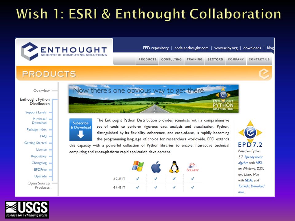
ESRI and Enthought ensure distributions are compatible ArcGIS leverage the 100 packages in the Enthought Python Distribution Serious Python users to leverage ESRI tools

14
Unidata has a Java Common Data Model (CDM) C Common Data Model (libCF) still in development We need a Python (or C) CDM library! When we have one, ESRI can leverage it!

15
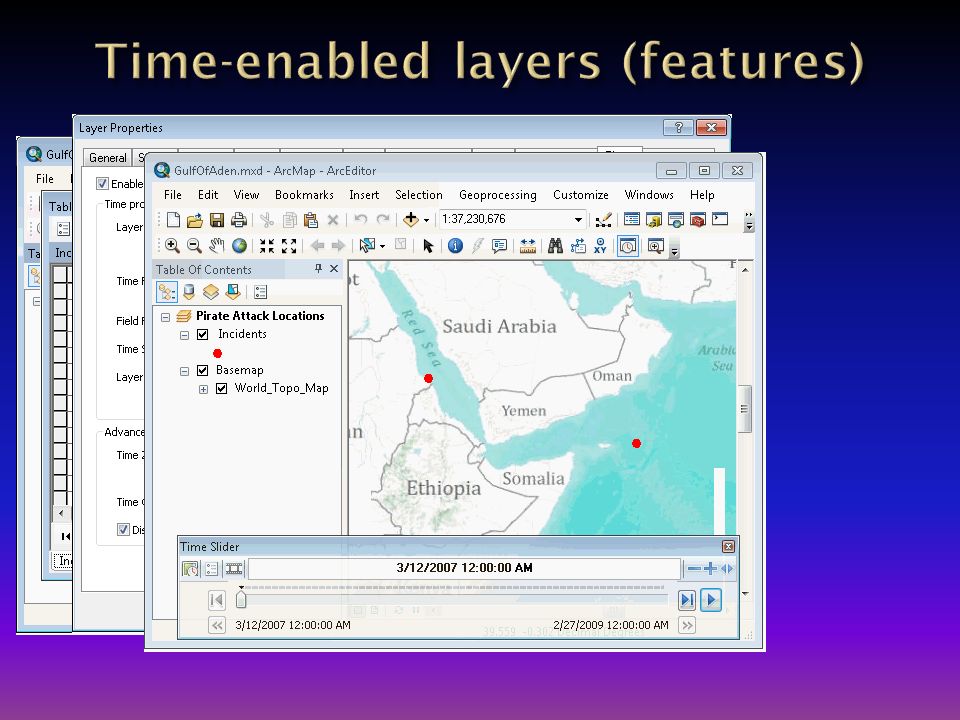
ArcGIS more of an integrative platform ArcGIS users can exploit the world of OPeNDAP data Dan Sampson, coastal zone manager in Massachusetts, working in ArcGIS, can create his own products from OPeNDAP Data

16
ROMS POM WW3 WRF ECOM NcML Common Data Model OPeNDAP+CF WCS NetCDF Subset Service THREDDS Data Server Standardized (CF) Virtual Datasets Nonstandard Output Files (distributed) Web Services Matlab Panoply IDV ERDDAP Clients NetCDF -Java Library or Service NcML, NetCDF-Java and THREDDS Data Server built and supported by Unidata under NSF-support WMS ncISO ArcGIS10 NetCDF4- Python FVCOM Python EDC ERDDAP NetCDF-Java
 Virtual Datasets Nonstandard Output Files (distributed) Web Services Matlab Panoply IDV ERDDAP Clients NetCDF -Java Library or Service NcML, NetCDF-Java and THREDDS Data Server built and supported by Unidata under NSF-support WMS ncISO ArcGIS10 NetCDF4- Python FVCOM Python EDC ERDDAP NetCDF-Java")
17
Geoportal Server Broker Data ServersCatalog Services THREDDS-ncISO OGC-WCS OpenSearch OGC-CSW THREDDS-ncISO Clients GI-CAT Geoportal Server GI-Portal Geonetwork Python Matlab OGC-SOS

18
NCTOOLBOX http://code.google.com/p/nctoolbox links = opensearch(q) nc = ncugrid(links.dap{1}) z = nc.data(‘zeta’,…) grid = nc.grid(‘zeta’,…) z = 26441x1 single grid = lat: [26441x1 single] lon: [26441x1 single] time: 730970 (matlab datenum) connectivity: [52025x3 int32]
![NCTOOLBOX links = opensearch(q) nc = ncugrid(links.dap{1}) z = nc.data(‘zeta’,…) grid = nc.grid(‘zeta’,…) z = 26441x1 single grid = lat: [26441x1 single] lon: [26441x1 single] time: (matlab datenum) connectivity: [52025x3 int32]](http://images.slideplayer.com/32/9992359/slides/slide_18.jpg "NCTOOLBOX links = opensearch(q) nc = ncugrid(links.dap{1}) z = nc.data(‘zeta’,…) grid = nc.grid(‘zeta’,…) z = 26441x1 single grid = lat: [26441x1 single] lon: [26441x1 single] time: (matlab datenum) connectivity: [52025x3 int32]")
19
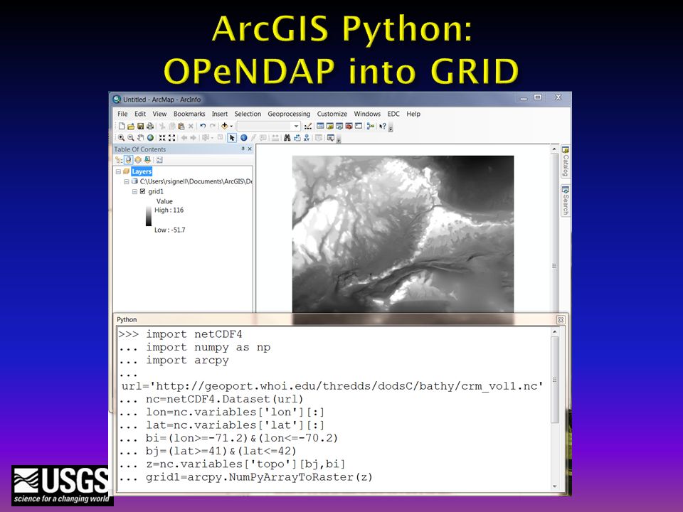
ArcGIS10.0 has Python integration There are several Python OPeNDAP modules How about PyDAP? NO! NetCDF4-Python? YES! Common interface for NetCDF3, NetCDF4 files and OPeNDAP datasets! (Uses Unidata’s NetCDF C library w/native OPeNDAP) But wait… NetCDF4-Python binary had not been built for Windows Python community’s Christoph Gohlke (UCI) to the rescue!!! (Python 2.6/2.7/3.0 Win32/Win64 and special ArcGIS10.0 and ArcGIS10.1 builds)
 But wait… NetCDF4-Python binary had not been built for Windows Python community’s Christoph Gohlke (UCI) to the rescue!!. (Python 2.6/2.7/3.0 Win32/Win64 and special ArcGIS10.0 and ArcGIS10.1 builds).")
21
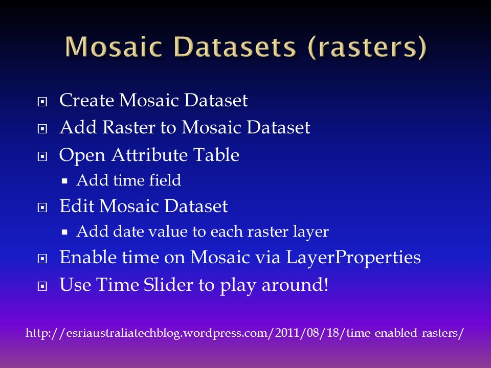
Create Mosaic Dataset Add Raster to Mosaic Dataset Open Attribute Table Add time field Edit Mosaic Dataset Add date value to each raster layer Enable time on Mosaic via LayerProperties Use Time Slider to play around! http://esriaustraliatechblog.wordpress.com/2011/08/18/time-enabled-rasters/
Similar presentations


 Mark Phillips (UNC-Asheville / NEMAC) Bill Hankins (STG Inc.)>")
>")
 Original version by Dave Fulker.>")
