Download presentation
Presentation is loading. Please wait.

1
Assertion and Authority: The Science of User-Generated Geographic Content Michael F. Goodchild University of California Santa Barbara

2
How is geographic information created? By authorities and their experts –USGS –NGA –Ordnance Survey –military in many countries –state and local governments Disseminated to non-expert users –with restrictions –at cost of production or reproduction? –restrictions since 9/11

3
The formal naming process U.S. Board on Geographic Names –1890 A hierarchy of boards from local to national –composed of experts –no role for amateurs, the general public Need to standardize –to avoid confusion –postal delivery

4
The Waldseemüller map St Dié-des-Vosges, 1507 A name that stuck

7
Volunteered geographic information (VGI) A phenomenon of the 21 st Century –recent months User-generated content Collective intelligence Crowdsourcing Asserted information The empowerment of millions of private citizens –largely untrained –no obvious reward –no guarantee of truth –no authority
 A phenomenon of the 21 st Century –recent months User-generated content Collective intelligence Crowdsourcing Asserted information The empowerment of millions of private citizens –largely untrained –no obvious reward –no guarantee of truth –no authority")
8
www.wikimapia.org

10
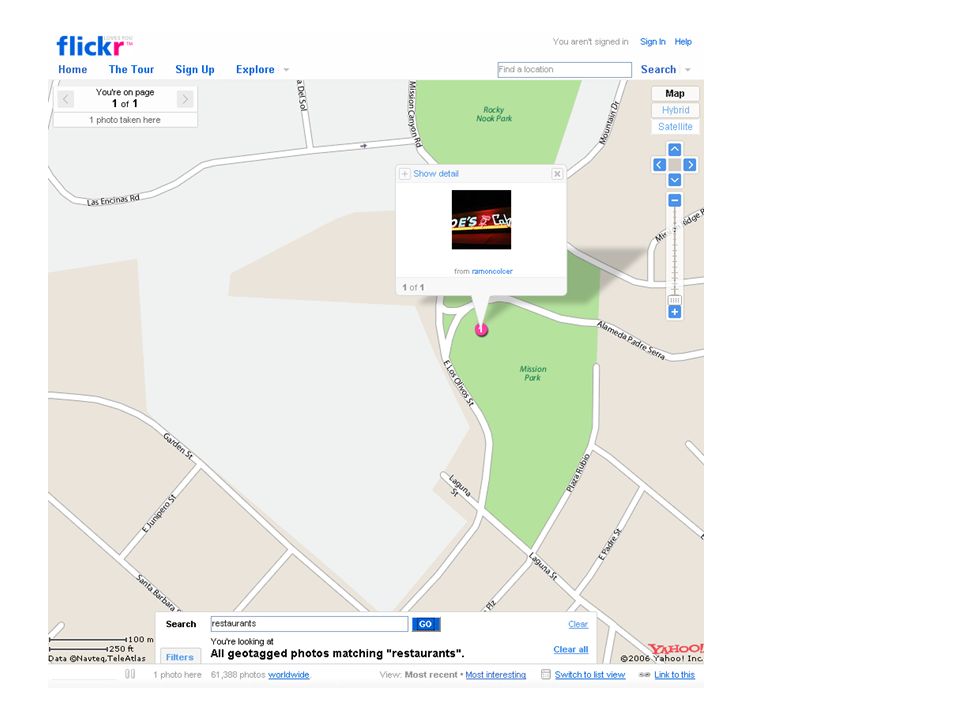
www.flickr.com

12
www.openstreetmap.org

15
Andrew Curtis, Department of Geography, Louisiana State University http://ncg.nuim.ie/ncg/events/20060125/

16
1. Google Earth image 2. 1843 map of London from David Rumsey collection 3. Pump and death locations from my own web site

17
National Spatial Data Infrastructure Breakdown of the authoritative system –government reluctance to fund –increasing demand –empowerment of smaller agencies and individuals –collapse of initial costs –abundance of data sources reversal of top-down flow 1992 National Academy report –a patchwork approach –Executive Order 12906 in 1994 –facilitated by standards –Federal Geographic Data Committee –Open Geospatial Consortium, ISO

18
What makes this possible? Web 2.0 –from downloaded content –to user-generated content –compare blogs, wikis Web search engines –making it possible to find user-generated content Google Earth mash-ups Jane Austen Google Earth –the power consumption problem –how long will Google scale?

20
Georeferencing The ability to determine location quickly and easily –most people do not know their latitude and longitude –what is at: latitude 34 deg 24 min 42.7 seconds north, 119 deg 52 min 14.4 sec west 236150m easting, 3811560m northing, UTM Zone 11 Northern Hemisphere National Grid reference 11SKU36151156 909 West Campus Lane, Goleta, CA 93117, USA Read coordinates from Google Earth etc. GPS

21
Service-oriented architecture Dynamic information flowing through Web sites –services that add value Successful services –geocoding –gazetteer lookup Mashups –services that create new information by combining sources

25
fundrace.huffingtonpost.com

26
Geotags Invisible codes inserted into Web text –Wikipedia entries

27
www.geonames.org

28
Concepts Spatial data infrastructure –1993 in U.S. –response to declining role of national mapping agency –increasing role of local agencies, private sector, individuals A patchwork –variable spatial detail determined by local demand, local supply –independent contributions –integrated with software –edge-matched –using IT to overcome differences and ambiguities rather than authority to remove them

29
Three types of sensor networks Inert, fixed Carried on moving objects –vehicles –pedestrians asthma research Human beings –6 billion intelligent sensors –informed observers –rich local knowledge –uplink technology broadband Internet mobile phone

30
Citizen science Networks of amateur observers –possibly trained, skilled Christmas Bird Count –thousands of volunteer participants –protocols Project GLOBE –an international network of school children –reporting environmental conditions –central integration and redistribution

31
Participant populations Open to all –Wikimapia, Flickr Trained or skilled volunteers –Christmas Bird Count School children –GLOBE Vehicle fleets –Inrix Farmers –precision agriculture Reversing the traditional top-down flow

32
Early warning Recent disasters –Indian Ocean tsunami –Hurricane Katrina Breakdown of technology –no power –no computers –no Internet connections Delays in acquiring imagery from satellites Human observers in the impacted area

33
Andrew Smith, MapAction, www.mapaction.org http://www.irlogi.ie/

34
The digital divide VGI implies connectivity –preferably broadband –for both uplink and downlink –what can be achieved with a cellphone and text? Roman alphabet dominant –problems with diacriticals

35
Why do people do this? Self-promotion –exhibitionism –information remains identified with source compare Census Altruism –a belief that everything on the Web can be found –and will be used to good effect A desire to fill gaps in available data –especially in areas where data are not available –or where access is denied for security Sharing with friends, relatives –but accessible by all

36
The value of VGI A significant contribution to geography –enhancing our knowledge of the Earth –local focus –engaging citizens Many unresolved questions –trust, credibility –preservation –social psychology

37
Emphasis on the easy stuff Placenames, streets, pictures Do other types of geographic information require experts? –soil maps precision agriculture gardeners Neogeography –a new world in which the distinction between expert and non-expert disappears

38
Forms of expertise Measurement –GPS –precision agriculture Cartography –distributed software Subject matter –for generic purposes Local area

40
Authority and assertion Traditional mapping to high quality –authoritative The Wikipedia process –anyone can edit –reviewed by volunteers –Google Maps The potential for hybrids –MapCorps

44
Towards a research agenda Technical –conflation –partial correction and update –SOA standards –metadata –quality control and assurance Social psychology –who participates? –local expertise –thematic expertise –privacy, access rights

45
Summary points A rapidly changing world –very strange to its former leaders Engagement of the general public –neogeographers –Vienna in 1683 –a willingness to volunteer Who are the experts? –we are all local experts A more dynamic view of geography –a tradition of leisurely activity

Similar presentations


 Focuses on research of the coupled dynamics of social- ecological systems (SES) and the translation of.>")


 Human Sensor Web project h2.0 Inform and Empower Initiative Human.>")
>")


 69:211–221 DOI 10.1007/s10708-007-9111-y Presented by: Group.>")


 667-9420 x165>")


