Download presentation
Presentation is loading. Please wait.

1
A processing package for atmospheric correction of compact airborne spectrographic imager (casi) imagery over water including a novel sunglint correction Peter Land Remote Sensing Group, Plymouth Marine Lab, Prospect Place, West Hoe, Plymouth PL1 3DH peland@pml.ac.uk
 imagery over water including a novel sunglint correction Peter Land Remote Sensing Group, Plymouth Marine Lab, Prospect Place, West Hoe, Plymouth PL1 3DH")
2
Background Sunglint is a severe problem for aircraft imagery, often rendering the images unusable Methods which mask out areas of high sunglint require human intervention and are subjective Sunglint has a well defined spectral shape, and though its spatial distribution is highly variable and essentially random, its large scale distribution is quite well behaved and predictable given the wind speed

3
Algorithm overview A processing package has been developed which atmospherically corrects casi images over water It is particularly suited to open ocean case 1 waters with uniform aerosols and wind, but will work anywhere that the standard SeaWiFS Arnone algorithm is acceptably accurate It includes a novel and effective sunglint correction

4
Basis of the algorithm Ancillary data are read and interpolated in time and space, spectral data are interpolated to the casi wavebands used Tau and WS are adjusted to minimize the deviation from the theoretical NIR path radiance and sunglint for a ‘typical’ image line, with optional Arnone correction for NIR water leaving radiance. The optimized tau is assumed constant across the image. Actual (highly variable) sunglint is then calculated at each pixel with image- averaged geometry to give an estimate of surface albedo Finally, the path radiance is calculated at each pixel using the exact pixel geometry, and sunglint recalculated and subtracted to give water leaving radiance, chlorophyll etc. If the NIR aerosol optical depth (tau), wind speed (WS) and surface albedo are known, the path radiance and average sunglint can be calculated along a given image line using the Guzzi et al model
 sunglint is then calculated at each pixel with image- averaged geometry to give an estimate of surface albedo Finally, the path radiance is calculated at each pixel using the exact pixel geometry, and sunglint recalculated and subtracted to give water leaving radiance, chlorophyll etc. If the NIR aerosol optical depth (tau), wind speed (WS) and surface albedo are known, the path radiance and average sunglint can be calculated along a given image line using the Guzzi et al model.")
5
North Atlantic raw images from 13 June 2001

6
Stages of processing Rayleigh corrected aerosol corrected sunglint corrected and interpolated Rayleigh radiance aerosol radiance sunglint radiance

7
Stages of processing solid = measured dashed = Rayleigh corrected dash-dot = aerosol corrected dotted = sunglint corrected

8
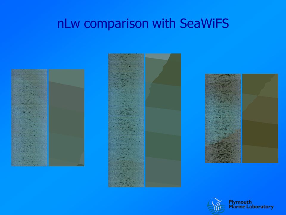
nLw comparison with SeaWiFS

10
solid = whole image dotted = centre sample crosses = SeaWiFS

11
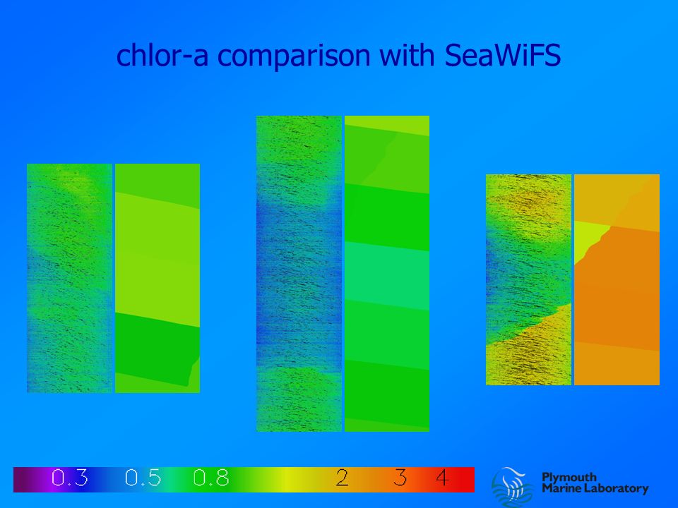
chlor-a comparison with SeaWiFS

13
Each point is a SeaWiFS pixel Error bars are relative

14
Conclusions Visual image quality is generally good, with little noise, few artefacts except residual limb brightening, and very good discrimination of sunglint. Retrieved spectra are believable in shape, with good correction for atmospheric gas absorption. Comparison with SeaWiFS shows relative overestimate of blue nLw and consistent underestimate in chlor-a, suggesting an under- correction for Rayleigh scattering. The values are within the 35% nominal error limits for SeaWiFS. Decrease in nLw and increase in chlor-a with decreasing height is also seen in SeaWiFS, hence is not an artefact of processing.

Similar presentations


 fluxes: an update Cédric Bertrand Royal Meteorological Institute of Belgium, Brussels, Belgium.>")


 Collaborators Hartmut Bösch (Univ Leicester) Rob Spurr (RT Solutions)>")
, Hartmut Bösch (JPL), Yuk Yung (Caltech) A Two Orders of Scattering.>")
