Download presentation
Presentation is loading. Please wait.

1
WGISS Disaster Management IG Lorant Czaran, UNOOSA Pakorn Apapanth, Natalia Kussul, Guoqing Li May 14, 2009 WGISS 27 Toulouse, France

2
Background In the WGISS 26 meeting WGISS members presented interesting use cases for disaster management China had experience on supply of near Real Time Data for Earthquake Response Ukraine uses Grid and Sensor Web Technologies for Flood Management Thailand develops a Clearinghouse for Disaster Management in SE Asia. UNOOSA found that these use cases are best practices and can directly benefit UN and other users if working process model is well developed The UN-SPIDER SpaceAID concept

3
Experiences in China and Ukraine

4
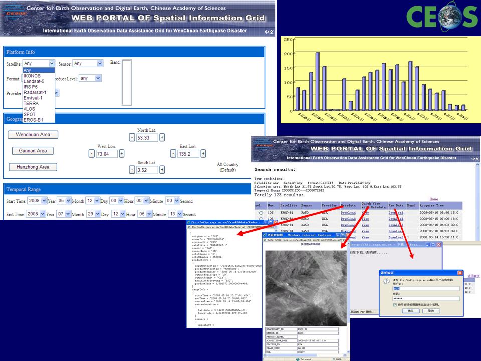
02:28 pm, May 12, 2008 Wenchuan, Sichuan, China The epicenter of the earthquake, Wenchuan, is about 90 miles from Chengdu. The energy released is great than that of 500 atomic bombs. More than 85,000 people were confirmed dead, more than 20,000 still missing, and more than 4.7 million houses collapsed or heavily damaged. Wenchuan earthquake case

5
At the very beginning of this event, many International Space Agencies showed their willingness to provide EO data assistance to China WGISS played an important role in calling for such activities within a very short time Over 1,500 image scenes supplied, less than 20% Charter

6
ftp Agency Contribution countries Agency Contribution countries Agency Disaster Country Agency Disaster Country Next generation technologies --- grid based easy Portal It is fast construction method! It is a very low-cost solution! It can overcome the CA problem

8
Rapid flood mapping from SAR satellite imagery Delivered within 24 h after data acquisition Satellite SAR instruments ERS-2/SAR ENVISAT/ASAR RADARSAT-1/2 Ground validation Chinese territory on river Huaihe 2008 => 95% match of satellite observations against field measurements Output format OGC-compatible: WMS, WCS, KML etc Space Research Institute NASU-NSAU (Ukraine) Experience in Flood Mapping
 Experience in Flood Mapping")
9
China, river Huaihe, 2007Mozambique, river Zambezi, 2008 India and Nepal, river Koshi, 2008Zambia, river Zambezi, 2009 Space Research Institute NASU-NSAU (Ukraine) Experience in Flood Mapping Australia, river Norman, 2009 Vietnam, 2008
 Experience in Flood Mapping Australia, river Norman, 2009 Vietnam, 2008")
10
Space Research Institute NASU-NSAU (Ukraine) Experience in Flood Mapping Delays in information on flood event Delays in data delivery
 Experience in Flood Mapping Delays in information on flood event Delays in data delivery")
11
Creation in Ukraine the UN-SPIDER Regional Support Office

12
To date ACTION WGISS-26-4: Lorant (organizer), Natalia, Guoqing, Pakorn and Chuang to identify and contact the Agencies/individuals with which WGISS projects can interact to provide services during disasters. Use Grid and Wenchuan Earthquake experiences and recommendations to outline a clear process. (As a contribution to DI-06-09) In the CEOS-GEO remapping Workshop, WGISS was assigned to have an action to support DI- 06-09: Use of Satellites for Risk Management
 In the CEOS-GEO remapping Workshop, WGISS was assigned to have an action to support DI : Use of Satellites for Risk Management.")
13
13 DI-06-09_7: Use of Satellites for Risk Management Analyze the response by WGISS members to supply near real-time data to the responding agency. Develop a working process model to integrate and make use of existing technologies within WGISS/CEOS. Implement a prototype to demonstrate use of these integrated technologies for the process model for the earthquake scenario. CEOS Action Category:2 Lead Agency: UNOOSA, GISTDA Participating Agencies: NSAU, NRSCC Constellation: N/A Working Group: WGISS POC: Lorant Czaran and Pakorn Apaphant Deliverables: April 30, 2009 – Working Process to be developed June 30, 2009 – Testing the model September 30, 2009 – Working Process defined at WGISS 28 November 2009 – Document and include in WGISS Report at the CEOS plenary

14
Proposed work plan for a Disaster management IG Set up core team and volunteers Review new and past WGISS presentations to identify and map all existing projects and prototypes of interest to the task Attempt to organize these identified solutions in a complementary way, to ensure focused application with a view to sustainability Match available services and applications with known user requirements, identify gaps

15
(continued) Develop recommendations as a group based on identified issues and problems (see next slides) Demonstrate the possibility of fast access to- and more automated processing of newly collected imagery during disasters, to concretely support the response phase Build on existing efforts such as the ones presented, or the Caribbean or Namibia AIP initiatives, to extend their application Start with a Test Facility
 Develop recommendations as a group based on identified issues and problems (see next slides) Demonstrate the possibility of fast access to- and more automated processing of newly collected imagery during disasters, to concretely support the response phase Build on existing efforts such as the ones presented, or the Caribbean or Namibia AIP initiatives, to extend their application Start with a Test Facility")
16
possible TF Working Process flowchart

17
WDMTF Working Flowchart Disaster Event Decision Indentifying Action Announcement Data Collection FTP deploying Middleware developingPortal developing Portal Publish ISDR UNSPIDER WGISSCharter benefit country

18
WDMTF User Flowchart WDMTF PortalGrid Middleware security FTP security FTP WDMTF FTP security Space Agency

19
Expected TF first deliverables Refined Working Process model Mapping of all potential projects of interest, and of required data sources WGISS Demo at upcoming CEOS Plenary GEO task interaction Required data sources identified and committed to participate Other?

20
Issues ASTER DEM availability, better resolution global DEM for modeling Fast/easy access to base mid-resolution or SAR reference images (Landsat, ASTER, Radarsat, TSX etc.) SAR data contributions? SAR images should be most important for most disasters (earthquake, flood, storm) Open Access to imagery and data during serious disasters, relaxed licensing terms Limited flexibility of existing mechanisms such as the Charter Sample imagery availability for test facilities And more….
 Open Access to imagery and data during serious disasters, relaxed licensing terms Limited flexibility of existing mechanisms such as the Charter Sample imagery availability for test facilities And more…..")
21
Questions to be resolved How to indentify the major disaster events for response? How and when should the decision be taken? GLIDE? How many disaster cases to follow every year in this stage? (one or two per-year, more ….) How to announce member agencies to contribute? (by teleconference, mail, or other?) How fast is our target to respond? (day? week?) Who is the user of WDMTF testbed? (Affected country? ISDR? UN?) Should WGISS contact the users directly? Which agency will donate the temporary operational data storage, ftp space? How to organize the technical team to support the development of WDMTF components? Data policy and copyright?
 How to announce member agencies to contribute. (by teleconference, mail, or other ) How fast is our target to respond. (day. week ) Who is the user of WDMTF testbed. (Affected country. ISDR. UN ) Should WGISS contact the users directly. Which agency will donate the temporary operational data storage, ftp space. How to organize the technical team to support the development of WDMTF components. Data policy and copyright .")
22
Recommendation to WGISS plenary Interest Group? Encourage Agencies to support with imagery the Test Facility effort phase Support IG to identify means of operationalizing the developed Work Process for adequate response to future major disasters

Similar presentations


 CEOS Disaster SBA Team Coordinator Priority Actions GEO Disaster WP 2012-2015.>")

 Program Roadmap Updated June 6, 2013 RFI ATTACHMENT D.>")
 Stéphane Chalifoux (CSA, Vice-Chair WGDisasters) Andrew.>")


 Annual Report Brian Killough NASA Agenda Item #18.>")

 WGISS-39 May 11-15, 2015.>")
 Meixia Deng and Liping Di.>")