Download presentation
Presentation is loading. Please wait.

1
Soil Information System of the Danube River Basin - source of the data for flooding prediction models. Beata Houšková Soil & Waste Unit, Institute for Environment & Sustainability, JRC Ispra Italy

2
Soil Information System (SIS) on Danube river basin Flood Risk Assessment Project Georeferenced Soil Database of Europe Odra river basin – pilot project (Development of the soil digital database for the Odra basin at the scale 1:250,000. Final report, Warsaw, 2001)
.")
3
Flood Risk Assessment Project LISFLOOD model – evaluation of flood risk in different time interval

4
The structure of LISFLOOD model

5
Cascade structure of LISFLOOD model 4. LISFLOOD-FF: a flood forecasting model

6
Use of Soil data in LISFLOOD model Inputs topsoil texture subsoil texture depth to bedrock Parent material topsoil VanGenuchtenparameters subsoil VanGenuchtenparameters HYPRES Infiltration parameters water storage Groundwater parametersgroundwater infiltration h/v transport

7
Georeferenced Soil Database of Europe (1:250,000)
")
8
General Structure of the Database

9
DANUBE BASIN DATABASE MEETING Explanatory meeting for contributors of data, JRC/Ispra/Soil&Waste Unit 22–23 January, 2004 Participants Representatives of contributors: Austria: Umweltbundesamt GmbH / Federal Environment Agency Ltd.,Abteilung Terrestrische Ökologie / Dept. Terrestrial Ecology, Wien. Czech Republic: University of Agriculture, Prague, Faculty of Agronomy; Department of Soil Science and Geology Hungary: Department of Soil Science and Agrochemistry, Szent Istvan University, Godollo University of Miskolc Slovak Republic: Soil Science and Conservation Research Institute, Bratislava Representatives of JRC/ Ispra IES: Soil&Waste Unit Land management Unit Institute for the Protection and Security of the Citizen (IPSC)
.")
10
Structure of Danube basin soil database Soil body definition table IdentifierTypeMandatoryExampleDescription soil_body (key) char 10yes33.2.SB821Code soil body (SB821) within soil region (33.2) sb_wrbchar 10yesstn-vr -LVWRB-classification 1 sb_matchar 3yes900Parent material 2 sb_obstchar 1yes1Depth to obstacle for roots 3 Number of points information: 1 200 points per country
 char 10yes33.2.SB821Code soil body (SB821) within soil region (33.2) sb_wrbchar 10yesstn-vr -LVWRB-classification 1 sb_matchar 3yes900Parent material 2 sb_obstchar 1yes1Depth to obstacle for roots 3 Number of points information: points per country")
11
Parent material

12
Root obstracle reasons

13
Structure of Danube basin soil database Soil body measurement table IdentifierTypeMandatoryExampleDescription soil_body (key)char 10yes33.2.SB821code soil body (SB821) within soil region (33.2) sbsm_Xnum 5yes12.10X-coordinate representative soil profile (eastern latitude) sbsm_Ynum 4yes35.20Y-coordinate representative soil profile (longitude) sbsm_altnum 4yes812Surface altitude (meter a.s.l.) sbsm_depwnum 3yes20average depth to water table (dm)
char 10yes33.2.SB821code soil body (SB821) within soil region (33.2) sbsm_Xnum 5yes12.10X-coordinate representative soil profile (eastern latitude) sbsm_Ynum 4yes35.20Y-coordinate representative soil profile (longitude) sbsm_altnum 4yes812Surface altitude (meter a.s.l.) sbsm_depwnum 3yes20average depth to water table (dm)")
14
Identifiers of Soil body measurement table

15
Structure of Danube basin soil database Soil horizon measurement table

16
Identifiers of Soil horizon measurement table1

17
Identifiers of Soil horizon measurement table2

18
Identifiers of Soil horizon measurement table3: Textural classes Class Description 0No texturePeat soils 1Coarse 18% clay and >65% sand 2Medium 18% clay < 35% and 15% sand, or 18% clay and 15% sand <65% 3Medium fine <35% clay and <15% sand 4Fine 35% clay < 60% 5Very fine 60% clay sand=fraction between 50 and 2000 μmeter; silt=fraction between 2 and 50 μmeter; clay= fraction smaller than 2 μmeter;

19
Identifiers of Soil horizon measurement table4: Gravel content classes ClassDescription 1Low gravel content 15% gravel 2High gravel content > 15% gravel

20
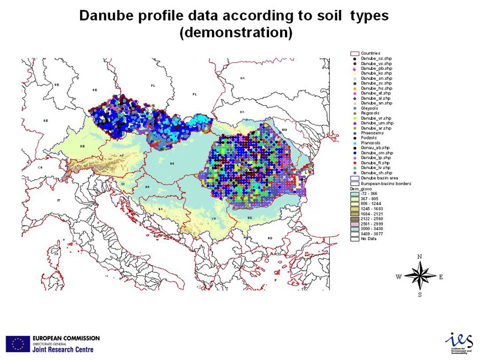
Soil data for flood & drought applications: present status Available 1M: - European Soils database 250 k: - Oder - Meuse - Danube: *Austria *Hungary *Slovak Republic *Czech Republic *Romania *Bosnia-Herzegovina Pending Slovenia Missing Germany Croatia Serbia Bulgaria Ukraine Moldovia

22
Total number of point data and number of Danube basin data (status till November 2004) CountryNumber of profiles delivered Number of Basin profiles Austria1,6681,626 Bosnia and Herzegovina 481343 Czech Republic1,201275 Hungary1,190 Slovakia1,9541,951 Romania1,2011,173 Total 7,695 6,558
 CountryNumber of profiles delivered Number of Basin profiles Austria1,6681,626 Bosnia and Herzegovina Czech Republic1, Hungary1,190 Slovakia1,9541,951 Romania1,2011,173 Total 7,695 6,558")
26
Soil body = Soil typological unit

27
Soilscape = Soil mapping unit

28
Contributions 2.Ad De Roo, Land Management Unit (LMU), IES, TP261, 21020, Ispra (Va), Italy. 3.Jean Dusart, Soil&Waste Unit, IES, TP 280, 21020 Ispra (VA), Italy. 4.Danube countries: SK, AT, CZ, RO, HU, BA (status of receiving data till November 25, 2004).
, Italy. 4.Danube countries: SK, AT, CZ, RO, HU, BA (status of receiving data till November 25, 2004)..")
Similar presentations


 179 final COMMUNICATION FROM THE COMMISSION TO THE COUNCIL, THE EUROPEAN.>")


 M = Moderate (40 - 80 cm) D = Deep (80 - 120 cm) V = Very deep ( > 120.>")


