Download presentation
Presentation is loading. Please wait.

1
A Unit of Terrestrial Ecosystem Inventory (TEUI) Prepared by Karen Bennett Regional Soil Scientist October 2011
 Prepared by Karen Bennett Regional Soil Scientist October 2011")
2
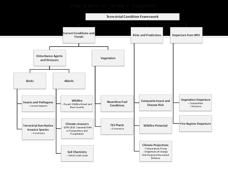
Terrestrial Condition Framework

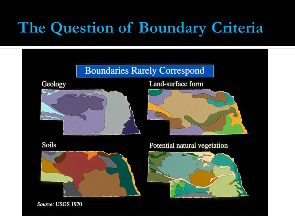
3
Watershed Condition Framework - Based on sub-watersheds -6 th field HUC Terrestrial Condition Framework - Based on Landtype Associations

4
Analysis UnitLevelDigitsAverage Size (mi 2) Name Region12177,560Pacific Subregion2416,800Columbia Basin3610,596Lower Snake Subbasin48700Imnaha Watershed510227Upper Imnaha River Subwatershed61240 (10- 40,000 ac) South Fork Imnaha River
 Name Region12177,560Pacific Subregion2416,800Columbia Basin3610,596Lower Snake Subbasin48700Imnaha Watershed510227Upper Imnaha River Subwatershed61240 (10- 40,000 ac) South Fork Imnaha River")
5
Over the past 15 years, 3 systems of prioritizing watersheds for protection and restoration have emerged in the Region

6
Ecological UnitMap Scale Range General PolygonName Domain1:30,000,0001,000,000s mi 2 Temperate Division1:15,000,000100,000s mi 2 Western Cordilla Province1:10,000,00010,000s mi 2 Northwestern Forested Mountains Section1:5,000,0001,000s mi 2 Klamath Mountains Subsection1:500,00010s to low 1000s mi 2 Serpentine Siskiyou Landtype Association 1:100,0001000s to 10,000s acres Coniferous Dissected Mountains Landtype1:50,000100s to 1000s acresJosephine Soil Series Landtype Phase1:24,000<100 acresJosephine 60-90% slope

7
Province Scale – dominant vegetation, - complex vertical soil/veg relationships

8
Section Scale 12 Sections – 7 with significant FS ownership Coast Range Cascades Eastern Cascade Slopes Blue Mtns Klamath Mtns. North Cascades 2 with Partial influence Columbia Plateau Northern Basin and Range 2 no influence Willamette Valley Puget Lowlands Snake River Plains Subsection Scale 94 subsections – 54 with significant FS ownership

9
A combination of geology, climate, geomorphology, morphometry, and vegetation that reveals similarities on a landscape. Classification and mapping of ecosystems Based on biotic and abiotic factors Similar capabilities and potentials for management Addresses sensitivity and resiliency of a landscape

14
Organizing and designing LTA map units Provides higher altitude view of Forest Provides means to analyze landscape at Regional and National level Inherent properties of soils and vegetation primary factors organizing management Identifies limitations for management options (geologic hazards) - Put Forest overview map here. -

15
Land use potential Capabilities, limitations Forest, grazing facilities, roads, transport, recreation, energy Hazards – slope stability, rockfall Fires Spread/Capture Put graphic of landslide terrain here.

16
Understanding watershed processes storm precipitation response water transport and availability Undestanding groundwater storage and recharge Understanding erosion and sediment Erosion rates and volumes Sediment storage and routing Put graphic here of a highly dissected, erodsing landscape adjacent to a more planear, hillslope in a single or adjacent watersheds to discuss understanding erosion and sediment transport in a watershed.

17
Wildlife habitat Migration corridors Aquatic habitat Stream dynamics Put graphic of meandering stream corridors here

19
TASKWHODates Create Initial draft of R6 LTAsRegional Soil Scientist & Ecologist with OSU June-October 2011 Local Forest ReviewInterdisciplinary Forest StaffOctober/November 2011 Completed R6 LTA MapsRegional Soil Scientist & Ecologist with OSU December/January 2012 Develop Regional Protocol for Terrestrial Conditon Framework Regional Implementation Team (members TBD) January 2012 Forest Collect Current Ecological Condition Data Forest TCF Implementation Teams (members TBD) February – April 2012 Final Regional LTA Maps with Descriptions Regional Soil Scientist & Ecologist with OSU March 2012 Forest Assessment of Ecological Condition Forest TCF Implementation Teams (members TBD) April – June 2012 Prioritization of Landscape Restoration Forest TCF Implementation Teams (members TBD) July – Sept 2012
 January 2012 Forest Collect Current Ecological Condition Data Forest TCF Implementation Teams (members TBD) February – April 2012 Final Regional LTA Maps with Descriptions Regional Soil Scientist & Ecologist with OSU March 2012 Forest Assessment of Ecological Condition Forest TCF Implementation Teams (members TBD) April – June 2012 Prioritization of Landscape Restoration Forest TCF Implementation Teams (members TBD) July – Sept 2012")
Similar presentations


>")