Download presentation
Presentation is loading. Please wait.

1
DISTRIBUTION OF ENDEMIC MAMMALS IN THE PERUVIAN YUNGAS Heidi Quintana & Victor Pacheco MUSEO DE HISTORIA NATURAL UNIVERSIDAD NACIONAL MAYOR DE SAN MARCOS LIMA - PERU

2
PERU The territory of Peru covers 1,285,256 km². It neighbors Ecuador and Colombia to the north, Brazil to the east, Bolivia to the southeast, Chile to the south, and the Pacific Ocean to the west.

3
Extension: 15 000 000 ha PERUVIAN YUNGAS Characteristics: The complex geology of the Andes has generated a landscape rich in biodiversity, endemism and unique ecosystems Elevation: 800 – 3600 m

4
MAMMALS

5
Endemism by Orders

6
METHODS

7
ORDERSSPECIES Rodentia29 Chiroptera4 Primates3 Artiodactyla1 Cingulata1 Didelphimorphia1 Paucituberculata1 40 Endemic Species 7 TYPE A TYPE B TYPE C

8
Habitat- Geographic Barriers Endemic Species LANDSCAPE ECOLOGICAL FACTORS Species Data RECORDS Tools

9
Polygons elaboration Compilation of Species Information (literature, museum records & observations) Polygons = Probable Distribution Create DataBase
 Polygons = Probable Distribution Create DataBase")
10
TYPE A: POLYGONS Polygon around the species records Arc View 3

11
TYPE B: DEDUCTIVE MODEL Species records Altitudinal ranges – Digital Elevation Model (DEM) North and South limits Arc View 3
 North and South limits Arc View 3")
12
TYPE C: INDUCTIVE MODEL Environmental variables layer Elevation MODIS Arc View 3 Maxent (a statistical mechanics approach)
")
13
Bio2 (Mean Temperature Diurnal Range) Bio3 (Isothermality) Bio13 (Precipitation of Wettest Month) Bio14 (Precipitation of Driest Month) Bio15 (Precipitation Seasonality) Elevation Slope Topographic exposure Percent tree cover* Evi_pca1_5*: Principal component axis 1 of temporal MODIS EVI data Evi_pca2_5*: Principal component axis 2 of temporal MODIS EVI data VARIABLES *summarized within 5 km moving window
 Bio3 (Isothermality) Bio13 (Precipitation of Wettest Month) Bio14 (Precipitation of Driest Month) Bio15 (Precipitation Seasonality) Elevation Slope Topographic exposure Percent tree cover* Evi_pca1_5*: Principal component axis 1 of temporal MODIS EVI data Evi_pca2_5*: Principal component axis 2 of temporal MODIS EVI data VARIABLES *summarized within 5 km moving window")
14
RESULTS

15
Distribution along the Yungas DEPRESION DE HUANCABAMBA DEPARTMENTS LIMITS Akodon aerosus

16
Distribution centered in the North DEPRESION DE HUANCABAMBA HUALLAGA RIVER Akodon orophilus

17
PERENE RIVER INAMBARI RIVER Oecomys phaeotis Central Distribution

18
INAMBARI RIVER DEPARTMENT LIMIT Distribution centered in the South Akodon kofordi

19
Sturnira nana Punctual Distribution

20
TAMBO RIVER DEPARTMENT LIMIT Carollia manu Exceptions:

21
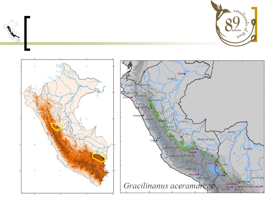
Gracilinanus aceramarcae

23
PRIORITY AREAS Deductive Model Yungas Centrales de Bolivia Inductive model Norwest of Huánuco Above Inambari River Cordillera occidental de Vilcabamba Cordillera de Paucartambo

24
The species distribution model allows us to minimize errors by collecting specimens nearer to the roads and rivers. Identify the remote natural areas in which it is likely that a species is located, based on the characteristics that they share with previously sampled sites. The polygons around the points dont provide the necessary precision for regional conservation in Peru. CONCLUSIONS

25
THANK YOU! SCGIS Heidi Quintana Navarrete Heidi.qn@gmail.com

Similar presentations


 Latin America Map Test – January 27 th Latin America Content Test – February 3 rd.>")


