Download presentation
Presentation is loading. Please wait.

1
The American Journey (History of Our Nation) A Meeting of Different Worlds Unit 1: Geography, Early Americans, Exploration, and Colonization
 A Meeting of Different Worlds Unit 1: Geography, Early Americans, Exploration, and Colonization")
2
SECTION 1 – Geography of the Americas Geography: The study of people, their environment, and their resources History: An account of what has happened in the lives of different peoples. 5 Themes of Geography

3
1.Location 2.Place 3.Interaction Between People and Their Environment 4.Movement 5.Region Forward

4
5 Themes of Geography 1.Location –Longitude: Lines measuring distances east and west from the Prime Meridian (0° longitude) which runs through Greenwich, England. –Latitude: Lines measuring distances north and south from the Equator (0° latitude) –Exact Location Ste. Genevieve, MO is located at: 38°N/90°W –Relative Location ThemesNext
 –Exact Location Ste. Genevieve, MO is located at: 38°N/90°W –Relative Location ThemesNext.")
5
Themes

6
5 Themes of Geography 2.Place –Physical features Climate, soil, plant life, bodies of water –Human features Housing, transportation, economy, languages, religions Themes

7
5 Themes of Geography 3.Interaction Between People and Their Environment –The environment affects people –People affect the environment Themes

8
5 Themes of Geography 4.Movement Occurs because people and resources are scattered unevenly around the globe. –People –Goods –Ideas Push-Pull factors of migration Themes

9
5 Themes of Geography 5.Region –An area of the world that has similar, unifying characteristics: Physical Human and cultural Themes

10
Geographical Maps Types of maps used when studying American History include: –Political –Physical –Population –Economic –Natural resource Maps

11
Political Map (people-created boundaries)
")
12
Physical Map (natural features) (more)
 (more)")
13
Physical Map (natural features)
")
14
Population Map (people)
")
15
Economic Map (how people make a living)
")
16
Natural Resource Map (links between resources & how people use the land)
")
17
Maps Other types of maps used when studying American History include: –Election maps –Product maps –Battle maps Maps show connections between geography and history.

18
Maps Cartographers are mapmakers Map projections are ways of drawing the Earth on a flat surface –Mercator projection Shows true shapes of landmasses Distorts size, especially for places far from Equator –Robinson projection Shows correct sizes and shapes of landmasses for most parts of the world

19
4 Basic Types of Landforms in the U.S. 1.Mountains –High, steep, rugged –Rise to elevation of at least 1,000 feet above surrounding land 2.Hills –Lower, less steep, more rounded 3.Plains –Broad areas, fairly level; few are totally flat –Not much higher than sea level 4.Plateaus –Large raised areas; flat or gently rolling –Range from 100s to 1,000s of feet above sea level –Basins are plateaus surrounded by mountains

20
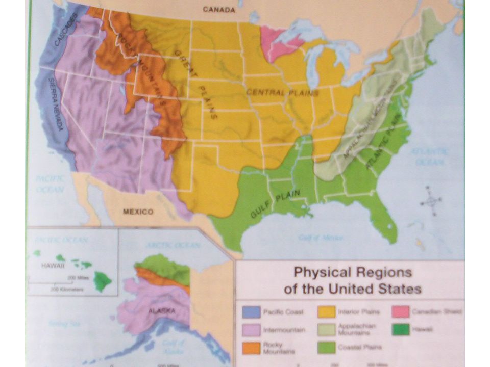
8 Physical Regions of U.S. & Natural Features 1.Pacific Coast –Tall mountain ranges –Cascades, Sierra Nevada 2.Intermountain –Mountain peaks, high plateaus, deep canyons, deserts –Grand Canyon, Great Salt Lake 3.Rocky Mountains –Includes some of the highest peaks in North America –A serious barrier to European settlement 4.Interior Plains –Large lowland area –Some parts rich in coal and petroleum; others have fertile soil –Great Plains (western part – dry) –Central Plains (eastern part)
 –Central Plains (eastern part).")
21
8 Physical Regions of U.S. & Natural Features 5.Appalachian Mountains –Lower and less rugged than Rockies –Heavily forested –Early European settlers had difficult time crossing –Has different names in different areas Green Mountains, Alleghenies, Blue Ridge, Great Smokies 6.Coastal Plains –Gulf Plain – large deposits of petroleum –Atlantic Plain – almost flat 7.Canadian Shield –Lowland area, hills and plains (mostly in eastern Canada) –Rich in minerals; lacks topsoil for farming 8.Hawaiian Islands –8 large islands and many smaller ones –Islands are tops of volcanoes (some are still active)
 –Rich in minerals; lacks topsoil for farming 8.Hawaiian Islands –8 large islands and many smaller ones –Islands are tops of volcanoes (some are still active).")
22
Physical Regions of the U.S.

23
U.S. Rivers and Lakes The Mississippi and Missouri rivers make up the longest and most important river system in the U.S. This river system flows through the Interior Plains into the Gulf of Mexico. Many tributaries (streams and smaller rivers) flow into this river system. –Among them are the Ohio, Tennessee, Arkansas, and Platte rivers The Mississippi carries moisture across the Interior Plains and serves as a means of transportation.
 flow into this river system. –Among them are the Ohio, Tennessee, Arkansas, and Platte rivers The Mississippi carries moisture across the Interior Plains and serves as a means of transportation..")
24
U.S. Rivers and Lakes Borders between nations –Rivers sometimes serve as political boundaries, forming parts of borders Rio Grande (between U.S. and Mexico) St. Lawrence (between U.S. and Canada) –The Great Lakes form part of the border between the U.S. and Canada – today, canals connect the 5 lakes, forming a major inland waterway Superior Michigan Huron Erie Ontario
 St. Lawrence (between U.S. and Canada) –The Great Lakes form part of the border between the U.S. and Canada – today, canals connect the 5 lakes, forming a major inland waterway Superior Michigan Huron Erie Ontario.")
Similar presentations