Download presentation
Presentation is loading. Please wait.

1
UPPER-LEVEL WINDS Atmospheric pressure, temperature and winds at surface

2
Weather conditions

3
Atmospheric pressure and elevation

4
Winds at upper level (500mb = ~5600 m of elevation or 18000 feet) 1 knot = 1 “nautical” mile/h 1 knot = 1.15 MPH 1 knot = 1.85 km/h
 1 knot = 1 nautical mile/h 1 knot = 1.15 MPH 1 knot = 1.85 km/h")
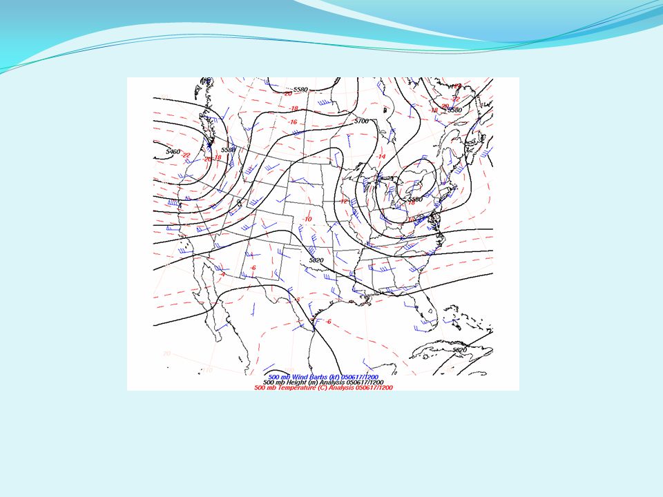
5
Height and pressure at upper level (500mb = ~5600 m of elevation)
")
6
Winds at upper level (200mb = ~11800 m of elevation)
")
7
WINDS ALOFT How does air move at higher elevations? The gradient force INCREASES with altitude stronger winds How does pressure changes with elevation?

8
HL Sea level H2 950mb H3 H4 900mb 850mb 800mb Pressure decreases with elevation: SLOWER in WARMER air FASTER in COLD air 950mb 900mb 850mb 800mb High Height Low Height Height (of pressure): HIGH in WARMER air LOW in COLDER air warmer colder HL H1 L H Figure 5.17, Page 139 POLE (90°) 30° latitude
: HIGH in WARMER air LOW in COLDER air warmer colder HL H1 L H Figure 5.17, Page 139 POLE (90°) 30° latitude")
9
500mb

10
GEOSTROPHIC WIND geostrophic wind When the Coriolis force balances the gradient force. The speed and direction of wind remain constant It takes place at upper levels

12
GLOBAL CIRCULATION AT UPPER LEVELS Weak equatorial easterlies (from ~ 25° to poles) Tropical high pressure belts (15° -20°) Upper air westerlies (from ~ 25° to poles, see undulations) Polar low (See Fig 5.19)
 Tropical high pressure belts (15° -20°) Upper air westerlies (from ~ 25° to poles, see undulations) Polar low (See Fig 5.19)")
13
ROSSBY WAVES Formation: 1.Waves arise in region of contact between cold polar air and warm tropical air (Polar front) Undulations of upper air westerlies
 Undulations of upper air westerlies")
14
ROSSBY WAVES FORMATION 2. Warm air pushes pole ward and a tongue of cold air is moved to south (undulation development) 3. Waves are strongly developed. Cold air are “troughs” of low pressure 4. Waves are pinched off, forming cyclones of cold air
 3. Waves are strongly developed. Cold air are troughs of low pressure 4. Waves are pinched off, forming cyclones of cold air.")
15
ROSSBY WAVES They are important for poleward heat transport Reason for variable weather in midlatitudes

16
JET STREAMS Regions at high elevation with strong wind streams According to the World Meteorological Organization we can call a “jet stream” any speed exceeding: 67mph, 58 knots, 108 km/h The core of jet streams reaches ~102mph They take place where atmospheric pressure gradients are strong The greater the contrast in temperature, the stronger the jet streams blow

17
1.Polar jet stream Follows the edge of Rossby waves. Found at 10-12 km elevation (33,000-40,000 ft) Wind speed: 75-125 m/s (170-280 mi/hr) 2. Subtropical jet stream In the subtropical latitude zone Speed 100-110 m/s 3. Tropical easterly jet stream In summer season, over Asia, India, Africa, only in Northern Hemisphere JET STREAM Figure 5.21
 Wind speed: m/s ( mi/hr) 2. Subtropical jet stream In the subtropical latitude zone Speed m/s 3. Tropical easterly jet stream In summer season, over Asia, India, Africa, only in Northern Hemisphere JET STREAM Figure")
18
JET STREAMS Jet streams tend to be weaker in summer than in winter Jet streams are less intense in the Southern Hemisphere due to smaller land masses Strongest jet stream have been recorded during winter over Southern Japan (speeds up to 310 mph)
")
21
Wind at 200 mb (~12 km or 8 miles)
")
22
Atmospheric pressure and temperature at surface (summer)
")
23
Atmospheric pressure and winds at surface

24
http://weather.unisys.com Winds at upper level (500mb = ~5600 m of elevation)
")
26
Winds at upper level (200mb = ~11800 m of elevation)
")
Similar presentations


>")
 and the Tropic of Capricorn (23.5S) The weather is very different.>")


 Flow of air at altitudes above 5000 meters (16,500 ft) Found in the upper troposphere.>")


