Download presentation
Presentation is loading. Please wait.

1
Advisory Committee on Water Information Status report: Subcommittee on Spatial Water Data Herndon, VA September 10, 2003

2
Integration of key Spatial Water Datasets National Elevation DatasetNational Hydrography Dataset Watershed Boundary DatasetNED-Hydrology COMPLETE 30meter COMPLETE 1:100K IN PROGRESS 1:24K IN PROGRESS 1:24K IN PROGRESS 1:24K COMPLETE 30meter “surface water geospatial framework”

3
Subcommittee’s role encourage facilitate review

4
1/3 arc second NED

5
Interagency Development of a Reference Set of Watersheds for the United States WBD

6
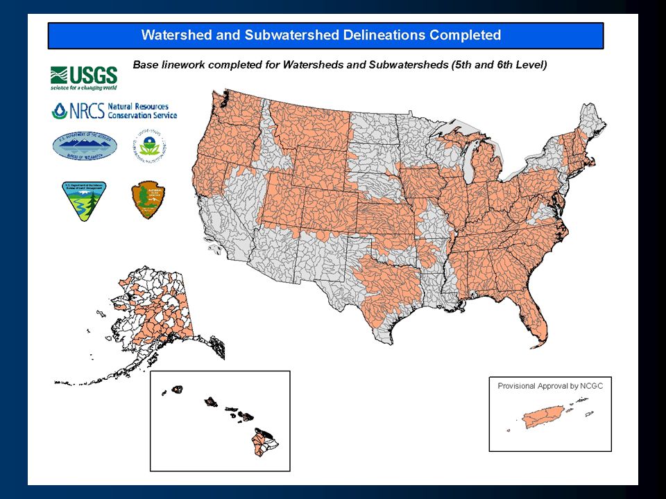
Hydrologic Units 2-digit= 1st level = 22 regions 4-digit= 2nd level = 222 subregions 6-digit= 3rd level = 789 accounting 8-digit= 4th level = 2223 cataloging 10-digit= 5th level = ~22,000 watersheds 12-digit= 6th level = ~160,000 subwatersheds new! WBD Where are we?

8
Submittal Projections WBD VERIFICATION PROCESS

9
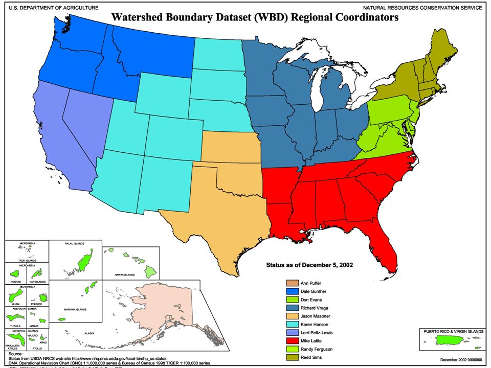
Funded Working Groups Salt Lake CityUSGS Ft. WorthNRCS SacramentoBOR PhiladelphiaEPA AtlantaUSGS EROS Data CenterUSGS

11
Problematic States Arizona: NRCS,USFS and BLM do not recognize need for 6 th Level Delineations. Idaho: Lack of in-kind funding. North Dakota: Inefficient process, minimal funding. Minnesota: Too much detail is being added well beyond the needs of the WBD. Estimated completion date at the current rate is 15 years. Plenty of funding, but have not been amenable to changing process. Louisiana: No local support. New York: Inefficient process, lack of coordination. New Jersey: Reluctant to modify existing dataset

12
Austin WBD MEETINGS

13
FY04 Meetings Portland, OR :Evaluation of NV, OR, ID, WA Syracuse, NY :Evaluation of NY, VT, NJ, PA Charleston, WV :Evaluation of WV, OH, VA Planned Needed Minneapolis, MN Madison, WINew Orleans, LA Columbia, SC :Wrap up of SC dataset Phoenix, AZ

14
Meeting Detail

15
Subcommittee on Spatial Water Data Guidelines Work Group CoastalWatersheds FGDC HUC unified Guideline National Hydrography Framework Standard Hydro Standard Work Group

16
National Hydrography Framework Standard Develop formal Content Standard for Hydrography. –describe a general model (a data dictionary, definitions, relationships) application-independent, supports international standards facilitates the exchange of data.
 application-independent, supports international standards facilitates the exchange of data..")
17
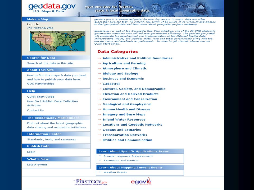
Geospatial One-Stop Key points –Develop and implement Framework Data content standards Elevation Orthoimagery Hydrography Administrative Boundaries Transportation Networks Cadastral Geodetic Control –Establish comprehensive Federal Portal –Director Hank Garie, USGS Co-chairman, Scott Cameron, DOI EGOV Initiative

18
NHD

20
NHD Partnerships

21
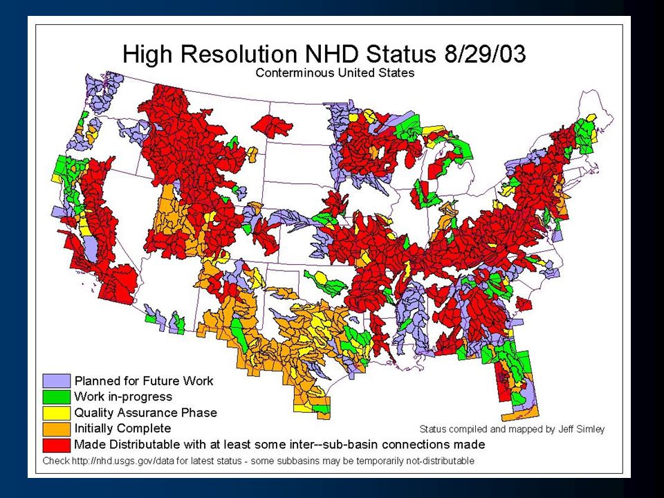
“high-res”NHD COMPLETE FY06

22
Density differences Paper map

23
NHD Problem: Drainage Density Artifacts reference paper map

24
FY04 THEME: “interoperable” Subcommittee on Spatial Water Data

25
Tying points to streams

26
Making it: –Easier –Faster –Less expensive Geospatial One Stop Purpose of the project: For all levels of government and the public to access geospatial information.

27
Federal Cities Counties Tribes User Community Data Searches Map Services Visualization GOS Portal DisasterManagement HomelandSecurityRecreation One Stop Smart Growth Citizen Services Watershed Management Other E-gov Initiatives Integration Services Support Government Business Support Decision Making Academia States Private

32
Request for “Data Category Managers”

Similar presentations

 Fifty States Initiative USGS Cooperative Agreement Partnership.>")

 Circular A-16 Supplemental Guidance, is the coordination of Federal geospatial.>")


 is composed of twelve regions. Each regional planning council is a public organization.>")


>")
 648-5569>")


