Download presentation
Presentation is loading. Please wait.

1
Alabama GIS Executive Council November 17, 2009

2
Alabama GIS Executive Council Governor Bob Riley signs Executive Order No. 38 on November 27 th, 2007 Governor appointed Jim Walker, Director of Alabama Department of Homeland Security, as Chair Tom Surtees, Director, Alabama Department of Industrial Relations elected as Vice Chair Brock Long, Director, Alabama Emergency Management Agency elected as Secretary Council meetings are quarterly at the call of the Chair Council reports annually to the Governor and the Alabama Legislature

3
Alabama Executive Council Membership Director, Alabama Department of Finance Commissioner, Alabama Department of Revenue Director, Alabama Department of Transportation Director, Alabama Emergency Management Agency Director, Alabama Department of Environmental Management Director, Alabama Department of Homeland Security Commissioner, Alabama Department of Conservation and Natural Resources Director, Alabama Department of Economic and Community Affairs Director, Alabama Department of Public Safety Director, Alabama Department of Industrial Relations Commissioner, Department of Agriculture and Industries Director, Association of County Commissions of Alabama Director, Alabama League of Municipalities The State Geologist of the Geological Survey of Alabama

4
Executive Order No. 38 Statement of Priorities Mission Statement (From EO38) The purpose of this statewide geographic information coordination effort shall be : 1.To establish policies relating to the use of geographic information, geospatial data, and related technologies; 2.To further cooperation among state, federal, and local government agencies; academic institutions; and the private sector to improve the quality, access, cost-effectiveness, and utility of Alabama’s geographic information; and 3.To facilitate the deployment of geographic information as a strategic resource in the State. Duties The purpose of this statewide geographic information coordination effort shall be: 1.To develop and adopt a Strategic Plan for a sustainable state program to coordinate GIS; 2.The resolution of policy and technology issues; 3.The coordination of interagency development of high-quality, accurate framework for geospatial data; 4.The coordination, direction, and facilitation of state, county, and local government GIS efforts; 5.Educational outreach program to coordinate geospatial training efforts; 6.Advising the Governor, the Legislature, and local governing bodies as to needed directions, responsibilities, and funding regarding geographic information; 7.Seeking input from all stakeholders at all levels of government, and the private sector to include public utilities, business professionals, industry leaders and others with a vested interest in GIS.
 The purpose of this statewide geographic information coordination effort shall be : 1.To establish policies relating to the use of geographic information, geospatial data, and related technologies; 2.To further cooperation among state, federal, and local government agencies; academic institutions; and the private sector to improve the quality, access, cost-effectiveness, and utility of Alabama’s geographic information; and 3.To facilitate the deployment of geographic information as a strategic resource in the State. Duties The purpose of this statewide geographic information coordination effort shall be: 1.To develop and adopt a Strategic Plan for a sustainable state program to coordinate GIS; 2.The resolution of policy and technology issues; 3.The coordination of interagency development of high-quality, accurate framework for geospatial data; 4.The coordination, direction, and facilitation of state, county, and local government GIS efforts; 5.Educational outreach program to coordinate geospatial training efforts; 6.Advising the Governor, the Legislature, and local governing bodies as to needed directions, responsibilities, and funding regarding geographic information; 7.Seeking input from all stakeholders at all levels of government, and the private sector to include public utilities, business professionals, industry leaders and others with a vested interest in GIS..")
5
Governor appoints Committee members January 14, 2009 First Organizational Meeting held March 30, 2009 Chris Johnson, Vice President of Geospatial Training and Application Center, U.S. Space and Rocket Center, elected as Chair Phillip Henderson, Director, GIS Management, Alabama Department of Economic and Community Affairs, elected as Vice-chair Bill Bass, Director, Property Tax Division, Alabama Department of Revenue, elected as Secretary Selection/election of two members to serve as voting members of the council David Palmer, Franklin County – representing Alabama Association of County Commissions and Ryan Pecharka – representing the Alabama League of Cities Alabama GIS Advisory Committee

6
Technical Sub-committee was established to review local and state requirements for acquisition of imagery, and to develop and recommend coordination agreements between agencies for future acquisitions in order to eliminate duplication and reduce costs. Chair, vice chair, and secretary of the Advisory Committee will serve as Ex-Officio Members of the Technical Subcommittee Alabama GIS Technical Sub-Committee

9
To agree upon direction for the development of a statewide strategic spatial information capability that can be used to support agency operations, critical infrastructure protection, emergency management operations, environmental conservation, asset management, economic development, and public health and safety at the state and local level. The Plan is a critical element for articulating a shared vision, and for building the partnerships necessary for disparate organizations to work together to achieve common goals. The key is to identify geospatial needs that are shared by many stakeholder groups. Effective strategic planning is essential for moving collaborative programs forward and gaining required support for such geospatial investments. Strategic Plan Purpose and Objectives

10
The Plan will… Consist of goals and objectives that can be translated through specific and measurable actionable business plans. Such business plans provide tangible steps that can be taken to build programs that benefit all participants and stakeholders across all levels of government. Help stakeholders lead Alabama into a spatially enabled information age. The Advisory Council will present Strategic Plan to the GIS Executive Council for approval and adoption. Once adopted, this will represent the Council’s reporting measures to the Governor for progress toward development of the statewide geospatial capability. Strategic Plan Purpose and Objectives (cont.)
.")
11
Strategic Planning Approach Plan is being developed with input and consensus of the Advisory Committee. Subcommittees are being formed as needed for the purpose of drafting specific focus area components of the strategic plan and program business plans. Work sessions are scheduled to develop components of the plan. Review sessions are periodically scheduled with the GIS Executive Council to obtain feedback and guidance in the plan development. Plan will be presented to the Executive Council for approval and adoption.

12
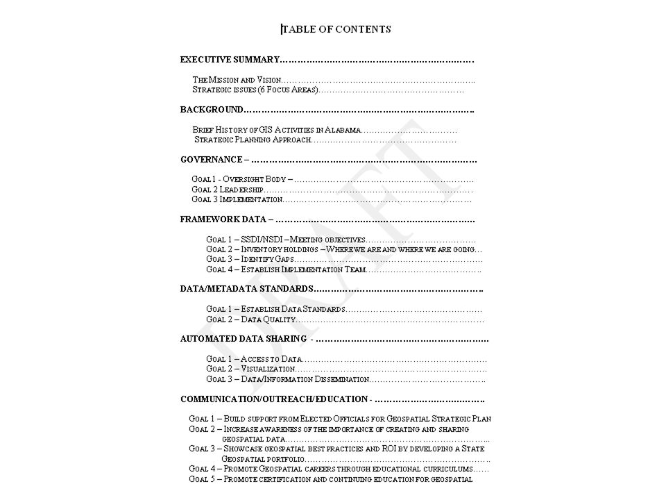
Current status of the Strategic Plan development Strategic Issues have been identified as 6 Strategic Focus Areas –Governance –Framework Data –Data/Metadata Standards –Automated Data Sharing –Communication –Education/Outreach

13
Strategic Plan The Mission The Alabama GIS Executive Council will foster the development of a spatial information capability for use by all jurisdictions and agencies to enhance decision-making processes. To ensure that the capability is sustainable, the Council will develop and implement a Strategic Plan with specific goals and objectives with measurable and actionable business plans. The Vision The State of Alabama will have a robust spatial information capability developed through a collaborative effort among the statewide geospatial community. This information will provide for effective operational, strategic,and executive decision-making to optimize the health and resilience of communities, provide access to public information and enhance the safety, economy, environment and quality of life in Alabama.

14
Questions?

Similar presentations


 Working Group HIFLD Partners Brief Feb 2014 1 FGDC Subcommittee Charter Update.>")


>")

![[Local] Workforce Investment Board New Member Orientation.](/18/5666872/big_thumb.jpg "[Local] Workforce Investment Board New Member Orientation.>")

 Sustainability for Early Childhood Systems Building.>")

