Download presentation
Presentation is loading. Please wait.

1
Idaho's Climate and Water Resource Forecast for the 2008 Water Year Sponsored by: The Climatic Impacts Group at the University of Washington and the Idaho Department of Water Resources The Good, The Bad, The Ugly… What Happened????? Ron Abramovich, Hydrologist, Water Supply Specialist USDA Natural Resources Conservation Service (NRCS) Snow Survey Office Boise Idaho
 Snow Survey Office Boise Idaho.")
2
The Good, The Bad, The Ugly…. What Happened?????
News Releases Date News Release Title January 8, 2007 Idaho Water Supply Outlook is Promising February 6, 2007 Dry Conditions Put Damper on Idaho’s Water Supply Outlook March 8, 2007 Recent Precipitation Rejuvenates Idaho's Water Supply April 6, 2007 Idaho's Water Supply Outlook is Disappointing June 5, 2007 Winter Too Short, Summer Too Early

3
The Good, The Bad, The Ugly…. What Happened?????
News Releases Date News Release Title January 8, 2007 Idaho Water Supply Outlook is Promising February 6, 2007 Dry Conditions Put Damper on Idaho’s Water Supply Outlook March 8, 2007 Recent Precipitation Rejuvenates Idaho's Water Supply April 6, 2007 Idaho's Water Supply Outlook is Disappointing June 5, 2007 Winter Too Short, Summer Too Early

4
The Good, The Bad, The Ugly…. What Happened?????
News Releases Date News Release Title January 8, 2007 Idaho Water Supply Outlook is Promising February 6, 2007 Dry Conditions Put Damper on Idaho’s Water Supply Outlook March 8, 2007 Recent Precipitation Rejuvenates Idaho's Water Supply April 6, 2007 Idaho's Water Supply Outlook is Disappointing June 5, 2007 Winter Too Short, Summer Too Early

5
The Good, The Bad, The Ugly…. What Happened?????
News Releases Date News Release Title January 8, 2007 Idaho Water Supply Outlook is Promising February 6, 2007 Dry Conditions Put Damper on Idaho’s Water Supply Outlook March 8, 2007 Recent Precipitation Rejuvenates Idaho's Water Supply April 6, 2007 Idaho's Water Supply Outlook is Disappointing May 6, 2007 Idaho's Ever Changing Water Supply June 5, 2007 Winter Too Short, Summer Too Early

7
Bear Mountain SNOTEL Site, elevation 5,400 feet, 24-hour precipitation Nov 6-7, am to 8am was 9.4 inches. Amount received midnight to midnight on Nov 6 was 8.4 inches. In addition, the snow pillow had 2.9 inches of snow water on Nov 4 of which all melted by Nov 8. Snow water melt on Nov 6 was 1.4 inches for a combined snow and rain runoff total of 10.8 inches. Previous 24-hour precipitation record was 6.9 inches on Nov 10, 1990 with 2.6 inches of melt occurring over several days.

8
2007 Snow and Precipitation

9
2007 Snow and Precipitation

11
2007 Snow and Precipitation

12
2007 Snow and Precipitation

13
May – September 2007 Idaho SNOTEL Precipitation
Schweitzer Basin, Pend Oreille Basin 2nd driest May-Sep in 26 years 7.5” of Precipitation, 61% Avg Mosquito, Couer D’ Alene Basin DRIEST May-Sep in 26 years 4.5” of Precipitation, 39% Avg Shanghi, N.F. Clearwater Basin 2nd driest May-Sep in 26 years 6.9” of Precipitation, 51% Avg Island Park, Henrys Fork Basin 2nd driest May-Sep in 26 years 4.2” of Precipitation, 44% Avg Secesh, Payette/Salmon Basin 4th driest May-Sep in 26 years 6.8” of Precipitation, 67% Avg Atlanta, Boise Basin 3rd driest May-Sep in 26 years 3.7” of Precipitation, 45% Avg Garfield, Little Wood Basin 4th driest May-Sep in 26 years 3.7” of Precipitation, 50% Avg Mud Flat, Owyhee Basin 2nd driest May-Sep in 26 years 2.0” of Precipitation, 44% Avg

14
March – July 2007 SNOTEL Precipitation Exceedances
Schweitzer Saddle, ID Precipitation = 13.3” 90-95% exceedance Big Creek Summit, ID Precipitation = 7.3” 95-99% exceedance Meadow Lake, ID Precipitation = 11.9” 80-90% exceedance Black Bear, MT Precipitation = 8.5” > 99% exceedance Hilts Creek, ID Precipitation = 5.7” 80-90% exceedance Island Park, ID Precipitation = 4.1” 99% exceedance

15
Hot March

16
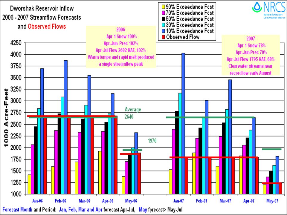
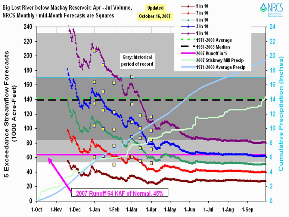
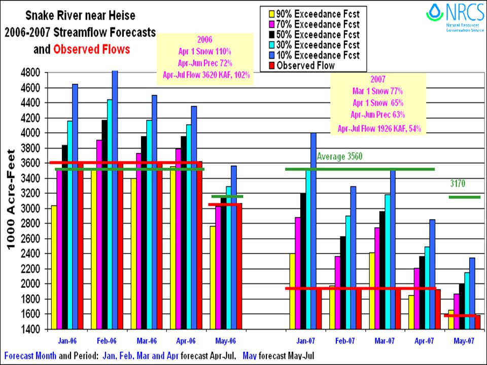
2007 Streamflow Forecasts What Happened?????

17
Water Year Precip is Avg

24
<>

27
Buffalo Creek is usually one of the streams that peaks the latest from snowmelt in the upper Snake River headwaters. Streamflow record starts in 1966. Date and CFS Peak Flow in 2007: May cfs peak May cfs peak June cfs peak Peak flow of 1860 cfs in 2007 nearly tied the previous lowest peak of 1850 cfs in 1992 AND earliest peak recorded was May 14, 1994, 2920 cfs. 2007 had two peak of 1860 on May 20 and 3rd peak of 1860 on June 6.

28
Highest cfs peak --- 6540 cfs on June 9, 1981
Latest cfs peak --- July , 3940 cfs The 2nd peak flow in 2007 had less volume associated with it when compared to first peak. Third peak of 1650 cfs occurred on June 17. All are based on provisional data.

29
Snowpack Needed for 2008 Season
Analysis is Based on September 30, 2007 Reservoir Storage Current Storage is Projected for March 31, 2008 Estimated Levels Required Streamflow Needed to Meet Irrigation Agriculture Demand Based on SWSIs (Surface Water Supply Index) Snowpack Needed for 2008 is Determined by Looking at Years When We had a Good Snowpack and Worst Case Scenarios Leading into or during the Snowmelt Runoff Season: Low Soil Moisture Low Groundwater Levels Dry Spring Cumulative Drought Effects 1989 is Good Example of Bad Runoff Year – snowpack was about average, but runoff was below to much below average due to dry spring and consecutive of drought years.
 Snowpack Needed for 2008 is Determined by Looking at Years When We had a Good Snowpack and Worst Case Scenarios Leading into or during the Snowmelt Runoff Season: Low Soil Moisture. Low Groundwater Levels. Dry Spring. Cumulative Drought Effects is Good Example of Bad Runoff Year – snowpack was about average, but runoff was below to much below average due to dry spring and consecutive of drought years.")
33
2007 Castle Rock Fire Location SNOTEL site Miles 2 4 8

34
2007 Castle Rock Fire Burned Area by Aspect Acres Burned ASPECT Level:
North: East: South: West: 629 57,568 64,822 45,601 41,880 ASPECT Level North East South Miles 1 2 4 West

35
Burned Area by Elevation
2007 Castle Rock Fire Burned Area by Elevation Acres Burned 5859 – 6000: 6000 – 7000: 7000 – 8000: 8000 – 9000: 9000 – 9189: 1,012 53,110 108,431 48,545 521 ELEVATION 8000 – 9000 Miles 1 2 4

36
2007 Castle Rock Fire Topography view looking north Elevation (feet)
Low = 5859 High = 9189

39
2007 Runoff based increased Runoff Coefficients in the Streamflow Model after the 2007 Castle Rock Fire

41
2006 Runoff based increased Runoff Coefficients in the Streamflow Model after the 2007 Castle Rock Fire

42
Questions – Comments – Corrections This presentation and Snowpack Needed for 2008 for Other Basins is available on the Idaho Snow Survey Web Page at: Ron Abramovich, Water Supply Specialist USDA NRCS Snow Survey, Boise Idaho

Similar presentations


 at the University of.>")
