Download presentation
Presentation is loading. Please wait.

1
Feature Oriented Regional Modeling System (FORMS) – as a synthesis component of the Global and Coastal IOOS Avijit Gangopadhyay University of Massachusetts Dartmouth Email: avijit@umassd.eduavijit@umassd.edu Seed funded by NASA
 – as a synthesis component of the Global and Coastal IOOS Avijit Gangopadhyay University of Massachusetts Dartmouth Seed funded by NASA")
2
OUTLINE Feature Oriented Regional Modeling Concept -- Initialization/Synthesis Methodology Example of Strategy in Sicily Strait Shallow water applications – CCS Global Applications Feature oriented synthesis…..

3
Gulf Stream Front and Ring Analysis

6
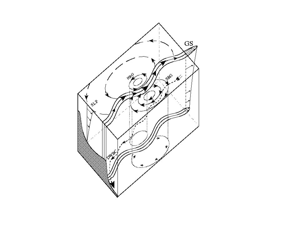
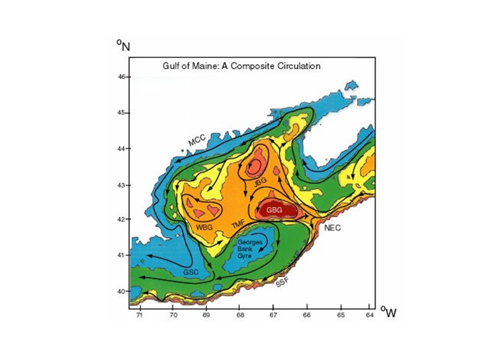
Features in Western North Atlantic Gulf Stream Warm Core Rings Cold Core Rings Southern Recirculation Gyre Northern Recirculation Gyre Deep Western Boundary Current Gangopadhyay et al., 3-part series in 1997: Journal of Atmospheric and Oceanic Tech. (14) 1314:1365 Maine Coastal Current NEC Inflow GSC Outflow Jordan Basin Gyre Wilkinson Basin Gyre Georges Basin Gyre Georges Bank Gyre Tidal Mixing Front Gangopadhyay et al. 2003: Continental Shelf Res. 23(3-4), 317-353 Gangopadhyay and Robinson, 2002: DAO 36(2002) 201-232 Deep Sea region (GSMR) Coastal region (GOMGB)
 1314:1365 Maine Coastal Current NEC Inflow GSC Outflow Jordan Basin Gyre Wilkinson Basin Gyre Georges Basin Gyre Georges Bank Gyre Tidal Mixing Front Gangopadhyay et al. 2003: Continental Shelf Res. 23(3-4), Gangopadhyay and Robinson, 2002: DAO 36(2002) Deep Sea region (GSMR) Coastal region (GOMGB).")
8
T(x,y,z)=T a (x,z)+ (x,z) (y) where, T a (x,z)={[T 0 (x)-T b (x)] (x,z) +T b } U(x,y,z)= (y){[U T (x)-U B (x)] (x,z) + U B (x)}
![T(x,y,z)=T a (x,z)+ (x,z) (y) where, T a (x,z)={[T 0 (x)-T b (x)] (x,z) +T b } U(x,y,z)= (y){[U T (x)-U B (x)] (x,z) + U B (x)}](http://images.slideplayer.com/16/5191687/slides/slide_8.jpg "T(x,y,z)=T a (x,z)+ (x,z) (y) where, T a (x,z)={[T 0 (x)-T b (x)] (x,z) +T b } U(x,y,z)= (y){[U T (x)-U B (x)] (x,z) + U B (x)}")
9
In general, a coastal current (CC), a front (SSF) and an eddy/gyre (E/G) are represented by: CC:T M (x, η, z) =T M a (x, z)+ α M (x, z) M (η) SSF:T ss (x, y, z) = T sh (x, z) + (T sl (x, z) – T sh (x, z)) ( , z) E/GT(r, z) = T c (z) - [T c (z) - T k (z) ] {1-exp(-r/R)} where, T M a (x, z), T sh (x, z) and T c (z) are axis, shelf and core (η) = (0 W) ( , z) = ½ + ½ tanh[( - .Z)/ ]
![In general, a coastal current (CC), a front (SSF) and an eddy/gyre (E/G) are represented by: CC:T M (x, η, z) =T M a (x, z)+ α M (x, z) M (η) SSF:T ss (x, y, z) = T sh (x, z) + (T sl (x, z) – T sh (x, z)) ( , z) E/GT(r, z) = T c (z) - [T c (z) - T k (z) ] {1-exp(-r/R)} where, T M a (x, z), T sh (x, z) and T c (z) are axis, shelf and core (η) = (0 W) ( , z) = ½ + ½ tanh[( - .Z)/ ]](http://images.slideplayer.com/16/5191687/slides/slide_9.jpg "In general, a coastal current (CC), a front (SSF) and an eddy/gyre (E/G) are represented by: CC:T M (x, η, z) =T M a (x, z)+ α M (x, z) M (η) SSF:T ss (x, y, z) = T sh (x, z) + (T sl (x, z) – T sh (x, z)) ( , z) E/GT(r, z) = T c (z) - [T c (z) - T k (z) ] {1-exp(-r/R)} where, T M a (x, z), T sh (x, z) and T c (z) are axis, shelf and core (η) = (0 W) ( , z) = ½ + ½ tanh[( - .Z)/ ]")
10
Strategy for GOMGB MCC, WBG, JBG, GBG, GBAG, TMF, SSF, Inflow/Outflow Feature Models at feature locations + Regional Climatology = FORMS

11
FORMS Protocol Identify Circulation and Water mass features Regional Synthesis -- Processes from a modeling perspective Synoptic Data sets -- in-situ and satellite Regional Climatology (Background Circulation) Objective Analysis (Climatology + Feature Models) Simulation -- Nowcasting/Forecasting
 Objective Analysis (Climatology + Feature Models) Simulation -- Nowcasting/Forecasting")
12
Feature oriented methodology is applicable to ALL different Numerical Models MOM (Modular Ocean Model) ROMS (Regional Ocean Model System) POM (Princeton Ocean Model) HYCOM MIT GCM HOPS (Harvard Ocean Prediction System) Finite Element / Finite Volume models It is an Initialization and Assimilation Methodology
 ROMS (Regional Ocean Model System) POM (Princeton Ocean Model) HYCOM MIT GCM HOPS (Harvard Ocean Prediction System) Finite Element / Finite Volume models It is an Initialization and Assimilation Methodology")
15
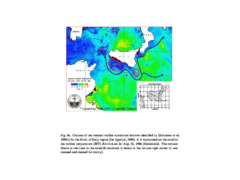
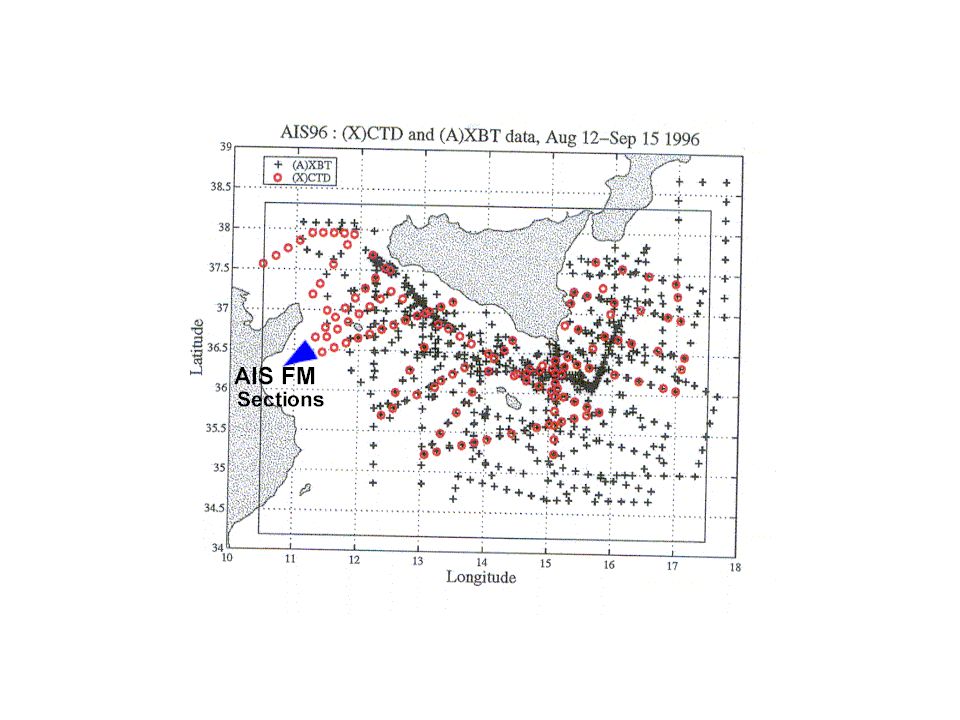
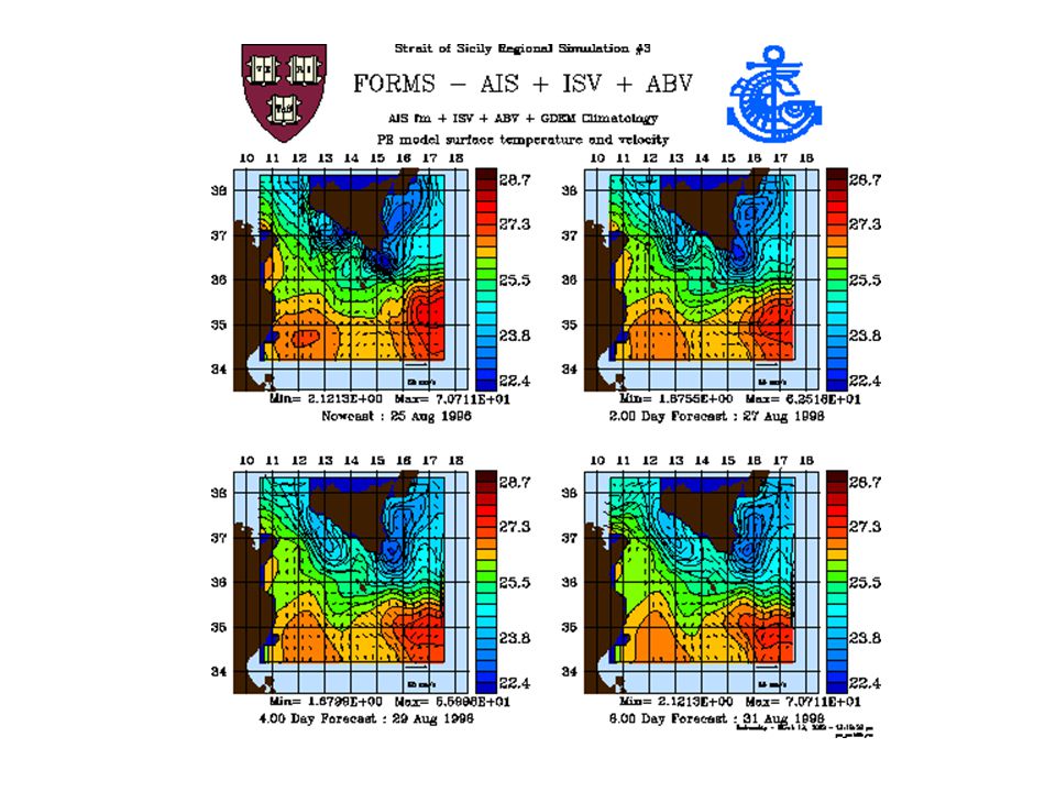
Strait of Sicily Feature Oriented Regional Modeling Set Up

17
FORMS Applications in Different Oceans OceanApplication Western North AtlanticOperational Modeling, e.g. AFMIS- RFAC Strait of SicilyDynamical Analysis Monterey BayReal-time forecasting w/ ROMS: AOSN-II in summer 2003 upwelling Brazil CurrentMeander-eddy-Upwelling Interaction Persian Gulf, Arabian Sea, Red Sea Monsoonal FORMS Chilean Waters - Northern Humboldt Currents Nested Biophysical Modeling

19
Shallow water feature models Use of ‘intelligent observations’ that are important to resolve the scales and represent the underlying dynamical processes Not only temperature-salinity structure, but include first-order dynamics Process-oriented feature models

20
Arabian Sea - Persian Gulf – Red Sea

22
Meander-eddy-Upwelling System

23
Elements of Synthesis Synthesis of Multi-sensor observational system: Satellite (SST, SSH, SSC), in-situ, CODAR -- using feature-oriented approach Process-oriented shallow water feature models Feature Tracking -- High resolution data fusion EOF analysis for Vertical Structure determination (Warn-Varnas et al., 2004) High-resolution regional climatology Dynamical Adjustment via Models -- FORMS
, in-situ, CODAR -- using feature-oriented approach Process-oriented shallow water feature models Feature Tracking -- High resolution data fusion EOF analysis for Vertical Structure determination (Warn-Varnas et al., 2004) High-resolution regional climatology Dynamical Adjustment via Models -- FORMS")
24
Some more thoughts Feature-oriented method allows for strategic deployment of available resources It optimizes (possibly maximizes) return on investments (ROIs) The ‘returns’ are not only in $$ but in science, too Minimizes human involvement (loss) – because it’s a knowledge-based system
 return on investments (ROIs) The ‘returns’ are not only in $$ but in science, too Minimizes human involvement (loss) – because it’s a knowledge-based system")
25
Thank You!! www.smast.umassd.edu/modeling/ www.smast.umassd.edu/modeling/

Similar presentations


 Intensity 1. BACKGROUND 2. HYPOTHESIS 3. OBSERVATIONS & MODEL 6. FUTURE WORK5. CONCLUSIONS 4. RESULTS Acknowledgements:>")


, University of Hamburg.>")
, ecology (e.g., local.>")


 es/gulf_stream.gif.>")


 Surface Global zonal mean.>")


