Download presentation
Presentation is loading. Please wait.

1
The Earth System Analyzer: Using all of the Data to Improve NOAA’s Mission Capabilities Alexander E. MacDonald NOAA Earth System Research Laboratory

2
Summary 1.Earth System Analyzer: What is it? 2.How does this system improve NOAA’s capabilities? 3.The 21 st century toolkit that makes it possible. 4. Earth System Analyzer Pilot Projects: CO2 and CH4

3
Earth System Analyzer “ A framework to continuously analyze the entire Earth system.” Physical Earth: 100 vertical levels, 10 km resolution, every hour, 100 variables. Chemical Earth: 100 vertical levels, 10 km resolution, every hour, 100 variables. Biological Earth: 10 km resolution, twice daily, 10,000 variables. Data Volume: 10 km and 100 vertical levels = 130 GB per day. 1 km and 1000 vertical levels = 140 TB per day.

4
NOAA Earth System Analyzer Objectives Improved “initial state based” weather prediction. Improved knowledge of Earth system climate forcing and feedback to constrain climate prediction. Determine the knowledge needed to be an honest broker for geo-engineering. Develop an “all NOAA” information system.

5
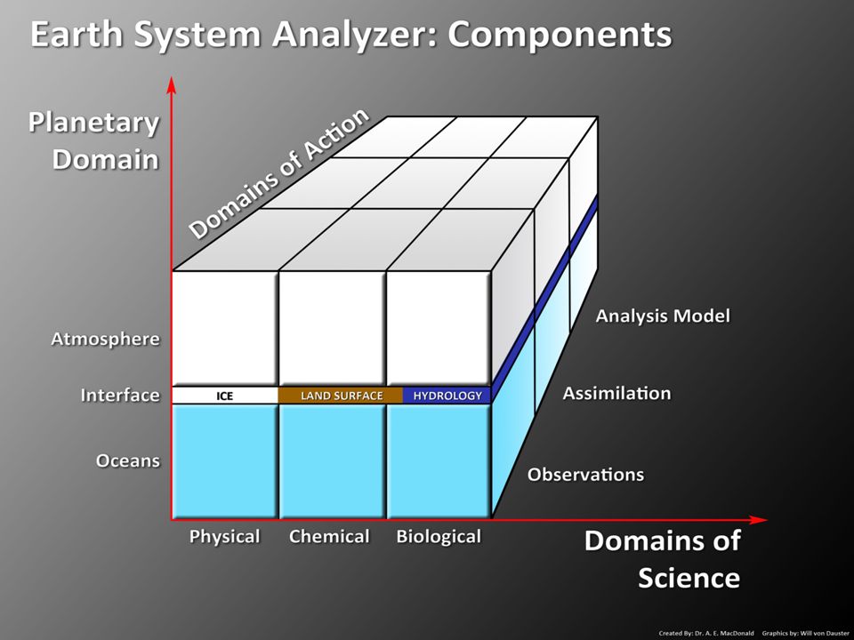
NOAA Earth System Analyzer Components 1. Multiple dynamics and physics assimilation for the major system components (air, ocean, land surface et.). 2. Continuous real time analysis. 3. Modeling frameworks.
. 2. Continuous real time analysis. 3. Modeling frameworks..")
7
Satellite and in situ observations are like gasoline and oil for an engine: YOU ALWAYS NEED BOTH.

8
Better use of data is the key to both weather and climate: Use every instrument on every available satellite. Use all of the in situ data. Use advanced assimilation for all fields.

9
Midnight visible image from Soumi NPP: Global convective initialization requires software to diagnose thunderstorms from visible images. Physical: Diagnose thunderstorms from visible imagery.

10
JPSS: Advanced Technology Microwave Sounder

11
NOAA Earth System Analyzer Key Innovations Weather: Use of all of the data with forward models, and a search for the best chemical, aerosol and biological tracers. Climate: Use years of full reanalysis. Constrain every variable, except the target. Get full statistical residual information.

12
Ben Santer: "The recent slow-down in observed surface and tropospheric warming is a fascinating detective story," Santer said. "There is not a single culprit, as some scientists have claimed. Multiple factors are implicated. One is the temporary cooling effect of internal climate noise. Other factors are the external cooling influences of 21st century volcanic activity, an unusually low and long minimum in the last solar cycle, and an uptick in Chinese emissions of sulfur dioxide. "The real scientific challenge is to obtain hard quantitative estimates of the contributions of each of these factors to the slow-down.“ Integrated, holistic observation based Earth system analysis : the only way to sort out the component contributions.

13
Chemical: There are about a hundred atmospheric constituents that need to be tracked. Black carbon (blue) and sulfates (green).
 and sulfates (green)..")
14
Sulfur Dioxide from the GOES R Advance Baseline Imager

15
JPSS: Cross-Track Infrared Sounder The 1315 channels of CRIS will allow diagnosis of chemical constituents as well as temperature and moisture soundings.

16
Biology: The most complex part of the Earth System.

18
Advanced geophysical assimilation.

20
Nonhydrostatic Icosahderal Model Time tendencyFlux termsForcing TermsSource Terms

21
Design of ESRL NIM: Speeds up chemical tracer calculations by factor of 10. Side 4 Side 6

22
Research Groups Global Long Term Observing Network Radiation Group GMD Core Aerosol Group Ozone Group Halocarbons Carbon Cycle Group GMD Network THDSUMSPOSMOMLOBRW Satellite Cal/Val Observations Cal & QC Observations Cal & QC Observations Cal & QC Observations Comparison & QC Observations Comparison & QC Observations Cal & QC Observations Comparison & QC Observations Comparison & QC Observations Cal & QC Observations Cal & QC WMO Networks Global Observing Networks

23
Current Network “Carbon Weather” Satellites TCCON Earth Networks CarbonTracker ™

24
A Vision for integrating NOAA’s data and short range predictions: Create an Earth System Analyzer: A framework to implement advanced physical, chemical and biological analysis of the entire ocean and atmosphere. Use this analysis to make short range predictions of the full Earth system. Use years of Earth System Analyzer data to constrain climate forcing agents (chemistry, aerosols, land-use change, etc.) Develop a NOAA-wide information system that encompasses all relevant ocean and atmosphere data.
 Develop a NOAA-wide information system that encompasses all relevant ocean and atmosphere data..")
25
NOAA Earth System Research Laboratory Boulder, Colorado Alexander.e.macdonald@noaa.gov

Similar presentations


>")


 Climate Change 2001: The Scientific Basis (Working Group 1; Sir John.>")

. Why TRMM? n Tropical Rainfall Measuring Mission (TRMM) is a joint US-Japan study initiated in 1997 to study.>")


 J. Kelly, Jr. National Weather Service Infusion of Satellite.>")
 Radiative Forcing (from IPCC WG-I, Chapter 2) Changes in Radiative Forcing Primary Source: IPCC WG-I Chapter.>")


