Download presentation
Presentation is loading. Please wait.

1
An Integral Perspective on the S.E. 17 Corridor October 29, 2013 Calgary

2
Background Existing Conditions Study process Alternatives Approved Plan Lessons Learned Status Presentation Outline

3
Background An integral part of Calgary transportation network The original main street of Forest Lawn community A secondary highway with regional connections Transit corridor with high transit ridership 17 Avenue Southeast Corridor:

4
Background In 2007 - Land Use Planning & Policy (LUPP) initiated Southeast 17 Corridor Study, In 2009 – Transportation Planning advanced a Transportation Planning Study to: Support the land use Increase mobility choices Develop a Transit supportive corridor Optimize infrastructure Develop Complete Street Identify a transit corridor connecting to the downtown
 initiated Southeast 17 Corridor Study, In 2009 – Transportation Planning advanced a Transportation Planning Study to: Support the land use Increase mobility choices Develop a Transit supportive corridor Optimize infrastructure Develop Complete Street Identify a transit corridor connecting to the downtown")
5
Background Study Area

6
Background: Land Use and Transportation Skeletal Road Arterial Street Industrial Arterial Urban Boulevard Neighborhood Boulevard Parkway

7
Existing Conditions Segment Right-of-Way (m) AADT# of Lanes 26 – 36 St38 – 5129,150 4 – 6 lanes 36 – 52 St20 – 5123,100 4 lanes 52 – 68 St29 – 3825,750 4 lanes 68 – 84 St47 – 4915,850 4 lanes
 AADT# of Lanes 26 – 36 St38 – 5129,150 4 – 6 lanes 36 – 52 St20 – 5123,100 4 lanes 52 – 68 St29 – 3825,750 4 lanes 68 – 84 St47 – 4915,850 4 lanes")
8
Background Calgary

9
Existing Conditions Mode Mode Share Pass. over 2 hrs Drivers75%4,934 Passengers8%493 Transit17%1,140 Bicycle0%0 Pedestrian0%0 TOTAL100%6,568 Transit Mode Share WB Trips (2009 AM Peak)
.")
10
Existing Conditions Transit Mode Share EB Trips (2009 AM Peak) Mode Mode Share Pass. over 2 hrs Drivers70%3,435 Passengers7%344 Transit23%1,140 Bicycle0%0 Pedestrian0%0 TOTAL70%3,435

11
Safety Concerns Disjointed and discontinuous sidewalks Inconsistent alignment and cross-section A single narrow sidewalk to accommodate active modes Lack of sidewalks and platforms at transit stations Access management issues Existing Conditions

12
Study Process The study process included : Development of a Shared Vision Brainstorming Sessions Stakeholder Consultation Public Information Sessions Development and Evaluation of Alternatives Conflict Resolution Lessons Learned Presentation to Council Final Report

13
Study Process Land Use: Character Areas Deerfoot to 36 St.36 St. to 54 St. 54 St. to Stoney

14
ALT 1: Median BRT with 4 Lanes of Traffic Alternatives

15
ALT 2: Curbside BRT with 4 lanes of traffic Alternatives

16
ALT 3: Median BRT with 2 Lanes of Traffic Alternatives

17
Alternatives Evaluation Based on the input received from the internal and external stakeholders, the alternatives were evaluated using the following multi factorial criteria: Safety Operations Alternative Modes Cost Social and Environmental Impacts Forest LawnInglewood Transit Improvement Operations and Safety Land Use and Community Impact Technical Feasibility Cost Implications

18
Approved Plan

19
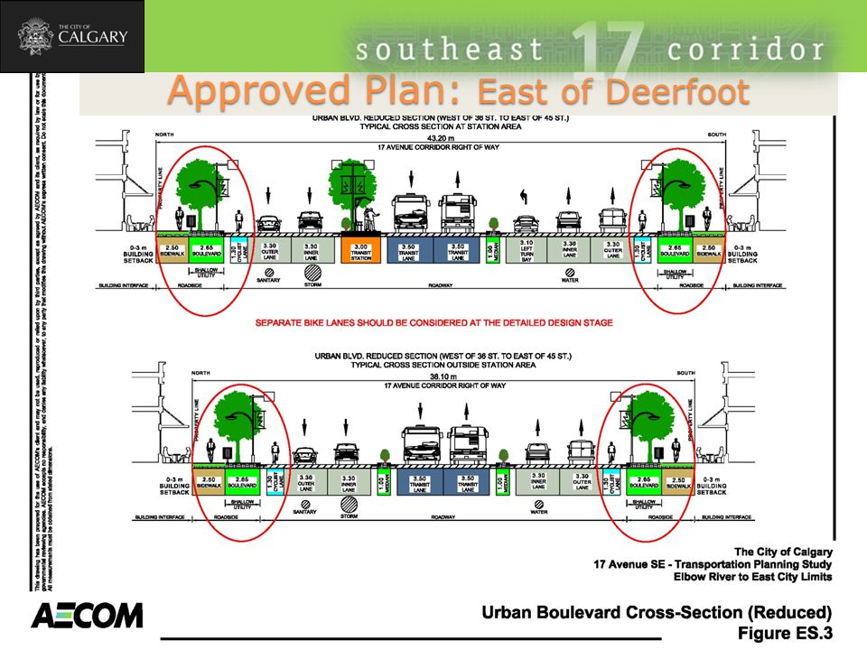
Approved Plan: East of Deerfoot

21
Approved Plan Land Required to Support Future Development

22
A dedicated transitway Serves lands adjacent to Blackfoot Truck Stop Continues local transit through (9th Ave SE) Inglewood Connects to SE LRT alignment Long Term Approved Plan: West of Deerfoot
 Inglewood Connects to SE LRT alignment Long Term Approved Plan: West of Deerfoot")
23
Approved Plan: West of Deerfoot – At Blackfoot truck Stop

24
Approved Plan: West of Deerfoot Short-Term Peak period peak direction transit lanes on 9th Ave S.E.

25
Lessons Learned Listen to your stakeholders Be prepared to talk Have open and candid discussions Every idea has a merit to be considered Hold a brainstorming session at the front end Include provision for unscheduled meetings Resolve issues through mini workshops PM to PM communication only ◦

26
Status Council directed Administration to: Evaluate and prioritize this project for inclusion in the next update of Transportation Infrastructure Improvement Plan (now Investing in Mobility), and Seek funding opportunities to advance the first phase of the project
, and Seek funding opportunities to advance the first phase of the project")
27
Questions

28
Modified Alternative 1 East of Deerfoot

29
Modified Alternative 2 East of Deerfoot

30
Approved Plan: East of Deerfoot

32
Integration of land use and transportation Four lane road Median transit lanes Bike lanes A boulevard Sidewalk Access consolidation Angle parking Linear and pocket parks

33
Background Transportation: Street Palette

34
Cost Estimates

35
Consultation Visioning Exercise Brainstorming Sessions Stakeholder Consultation Conflict Resolution Study Process

Similar presentations


 PEL Process Schedule Questions.>")


 Briefing on the Draft Update of the Bicycle and Pedestrian Plan for the National Capital Region Michael Farrell DTP Presentation to the.>")


