Download presentation
Presentation is loading. Please wait.

1
CHAPTER 10 The Coast: Beaches and Shoreline Processes
© 2011 Pearson Education, Inc.

2
© 2011 Pearson Education, Inc.
Overview Coastal regions constantly change. The beach is a dominant coastal feature. Wave activity continually modifies the beach and coastal areas. Waves affect deposition and erosion of sand and subsequent coastal features. Sea level changes affect the coast. Humans have attempted various coastal stabilization measures. © 2011 Pearson Education, Inc.

3
© 2011 Pearson Education, Inc.
Coastal Regions General Features Shore – the zone that lies between the low tide line and the highest area on land affected by storm waves Coast – extends inland as far as ocean related features are found Coastline – boundary between shore and coast © 2011 Pearson Education, Inc.

4
© 2011 Pearson Education, Inc.
Beach Features Beach – entire active area of a coast affected by waves. Consists of Shore – divided into Backshore – above high tide line; covered with water only during storms Nearshore – from low tide water line to where waves break at low tide Offshore – area beyond low tide breaking waves © 2011 Pearson Education, Inc.

5
© 2011 Pearson Education, Inc.

6
Composition of Beaches
Formed from locally available material May be coarse or fine grained sediment Boulders from local cliffs Sand from rivers Mud from rivers Significant biologic material on tropical beaches Example, Coral reef material Material is always in transit along the shoreline. © 2011 Pearson Education, Inc.

7
Sand Movement Along Beach
Two Major Types Perpendicular to shoreline (toward and away) Swash – water rushes up the beach Backwash – water drains back to the ocean Parallel to shoreline (up-coast or down-coast) Longshore current – transports sand along the beach © 2011 Pearson Education, Inc.
 Swash – water rushes up the beach. Backwash – water drains back to the ocean. Parallel to shoreline (up-coast or down-coast) Longshore current – transports sand along the beach. © 2011 Pearson Education, Inc.")
8
© 2011 Pearson Education, Inc.
Wintertime Beach Heavy wave activity Backwash dominates Sediment moved away from shore Narrower beach Flattened beach face Longshore bars are present Stormy weather © 2011 Pearson Education, Inc.

9
© 2011 Pearson Education, Inc.
Summertime Beach Light wave activity Wide, sandy berm Steep beach face Swash dominates Longshore bars not present Generally milder storms © 2011 Pearson Education, Inc.

10
Seasonal Beach Changes

11
© 2011 Pearson Education, Inc.
Longshore Transport © 2011 Pearson Education, Inc.

12
© 2011 Pearson Education, Inc.
Longshore Transport Also called longshore drift, beach drift, or littoral drift Only occurs in the shallow water surf zone Transports beach sediment in a zigzag fashion in the direction of the longshore current Beaches sometimes called “rivers of sand” © 2011 Pearson Education, Inc.

13
© 2011 Pearson Education, Inc.
Longshore Transport Millions of tons of sediment moved yearly Direction of transport changes due to wave approach In general, net sediment movement is southward along the Atlantic and Pacific coasts of the United States On Long Island it goes East West © 2011 Pearson Education, Inc.

14
Two Major Types of Shores
Erosional Shores Well-developed cliffs Exist where tectonic uplift of coast occurs U.S. Pacific coast is one example Depositional Shores Gradually subsiding shore Barrier islands and sand deposits are common © 2011 Pearson Education, Inc.

15
© 2011 Pearson Education, Inc.
Erosional Shores Protruding bits of land called headlands absorb much wave energy. Wave cut cliffs and sea caves are other features carved out by wave activity. © 2011 Pearson Education, Inc.

16
Depositional Shorelines
A bay barrier, or bay mouth bar, seals off a lagoon from the ocean. A Tombolo is an sand bar that connects an island to the mainland. Barrier islands are long offshore sand deposits that parallel the coast. A spit connects at one end to the mainland and hooks into a bay at the other. © 2011 Pearson Education, Inc.

17
Depositional Shorelines
Tombolo Barrier island © 2011 Pearson Education, Inc.

18
SPIT

19
Tombolo

20
Barrier Island

21
© 2011 Pearson Education, Inc.
Barrier Islands Common along East and Gulf coasts of the United States Do not exist along erosional shorelines Protect mainland from high wave activity Can migrate landward over time © 2011 Pearson Education, Inc.

22
Barrier Island Anatomy
Ocean beach Dunes Barrier flat High salt marsh Low salt marsh Lagoon Barrier Island Anatomy © 2011 Pearson Education, Inc.

23
© 2011 Pearson Education, Inc.
Barrier Islands Migrate landward over time due to rising sea levels Older peat deposits found on ocean beach © 2011 Pearson Education, Inc.

24
© 2011 Pearson Education, Inc.
Changing Sea Level Two major processes can change sea level: Local tectonic processes Global (eustatic) changes in sea level © 2011 Pearson Education, Inc.
 changes in sea level. © 2011 Pearson Education, Inc.")
25
© 2011 Pearson Education, Inc.
Changing Sea Level Local tectonic processes Example: the Pacific coast of the United States is currently being uplifted. Isostatic adjustments – rebound of Earth’s crust after removal of heavy loads or sinking with application of heavy loads Ice-loading from glaciers during ice ages © 2011 Pearson Education, Inc.

26
© 2011 Pearson Education, Inc.
Changing Sea Level Global (eustatic) changes in sea level Sea level changes worldwide due to Change in amount of available sea water Change in ocean basin capacity © 2011 Pearson Education, Inc.
 changes in sea level. Sea level changes worldwide due to. Change in amount of available sea water. Change in ocean basin capacity. © 2011 Pearson Education, Inc.")
27
Eustatic Changes in Sea Level
Some Mechanisms Ice ages lock seawater up in ice (glaciation) – sea level goes down Ice melting after an ice age (deglaciation) – sea level rises © 2011 Pearson Education, Inc.
 – sea level goes down. Ice melting after an ice age (deglaciation) – sea level rises. © 2011 Pearson Education, Inc.")
28
Eustatic Changes in Sea Level
Also caused by thermal expansion and contraction of seawater Physical property of water: warmer water expands and cooler water contracts. Sea level rises and falls in response to seawater temperature. This is roughly 2 meters (6.6 feet) per 1°C (1.8°F) change in temperature. © 2011 Pearson Education, Inc.
 per 1°C (1.8°F) change in temperature. © 2011 Pearson Education, Inc.")
29
Pleistocene Epoch and Today
From about 2 million to 10,000 years ago, a series of four ice ages affected Earth. Sea level was at least 120 meters (400 feet) below today’s sea level. If all remaining ice on Earth melted today, sea level would rise another 70 meters (230 feet). © 2011 Pearson Education, Inc.
 below today’s sea level. If all remaining ice on Earth melted today, sea level would rise another 70 meters (230 feet). © 2011 Pearson Education, Inc.")
30
Global Warming and Changing Sea Level
Globally averaged temperatures – about 0.6°C (1.1°F) warmer over last 130 years Sea level rose cm (4-10 in) over past 100 years As global warming continues, we will see a higher sea level. © 2011 Pearson Education, Inc.
 warmer over last 130 years. Sea level rose cm (4-10 in) over past 100 years. As global warming continues, we will see a higher sea level. © 2011 Pearson Education, Inc.")
31
© 2011 Pearson Education, Inc.
United States Coasts Atlantic coast Pacific coast Gulf coast © 2011 Pearson Education, Inc.

32
© 2011 Pearson Education, Inc.
Atlantic Coast Drowned river valleys common Average erosion is 0.8 meter (2.6 feet) per year; sea is migrating landward Delaware, New York, and Georgia have the most serious erosion problem. © 2011 Pearson Education, Inc.
 per year; sea is migrating landward. Delaware, New York, and Georgia have the most serious erosion problem. © 2011 Pearson Education, Inc.")
33
© 2011 Pearson Education, Inc.
Atlantic Coast Barrier islands Drowned river valleys © 2011 Pearson Education, Inc.

34
© 2011 Pearson Education, Inc.
Gulf Coast Low tidal range Generally low wave energy Tectonically subsiding Mississippi delta dominates Locally sea level rises due to compaction of delta sediments Average rate of erosion is 1.8 meters (6 feet) per year © 2011 Pearson Education, Inc.
 per year. © 2011 Pearson Education, Inc.")
35
© 2011 Pearson Education, Inc.
Pacific Coast Tectonically rising Experiencing less erosion than Atlantic or Gulf coasts Open exposure to high energy waves Average rate of erosion meter (0.016 feet) per year © 2011 Pearson Education, Inc.
 per year. © 2011 Pearson Education, Inc.")
36
© 2011 Pearson Education, Inc.
Hard Stabilization Structures built to decrease coastal erosion and interfere with sand movement Also called armoring of the shore Often results in unwanted outcomes Some structures may increase wave erosion © 2011 Pearson Education, Inc.

37
© 2011 Pearson Education, Inc.
Hard Stabilization Four major types of stabilization structures: Groins and groin fields Jetties Breakwaters Seawalls © 2011 Pearson Education, Inc.

38
Groins and Groin Fields
Built perpendicular to the beach Often made of rip rap, or large blocky material Traps sand upcoast, which can cause erosion downstream of the longshore current May necessitate a groin field, or a series of groins built along a beach © 2011 Pearson Education, Inc.

40
© 2011 Pearson Education, Inc.
Jetties Built perpendicular to shore Built in pairs Built to protect harbor entrances © 2011 Pearson Education, Inc.

41
© 2011 Pearson Education, Inc.
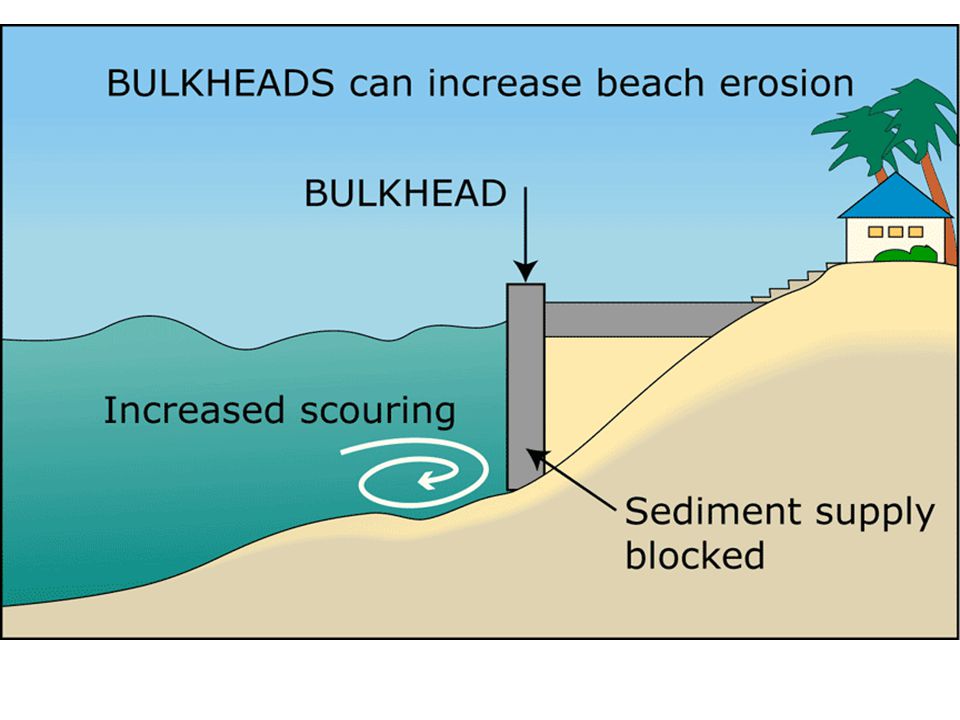
Seawalls Destructive to environment Designed to armor coastline and protect human developments One large storm can remove beach Wave activity eventually undermines seawall structure; need continual repair or will collapse © 2011 Pearson Education, Inc.

43
Alternatives to Hard Stabilization
Three major alternatives Construction restrictions Beach replenishment Relocation © 2011 Pearson Education, Inc.

Similar presentations


 tectonics active passive sea-level change may vary widely causes global (eustatic) from +6m to -125.>")


>")
