Download presentation
Presentation is loading. Please wait.

1
Mapping Humanity’s Knowledge and Expertise in the Digital Domain II Colin Cooper Dawn Wright Department of Geosciences Oregon State University

2
Objectives 1.To construct an information space visualization for the COMCI database using spatial metaphors 2. To build an online interface for disseminating spatialization schemes, allowing users to search the COMCI database

3
Benefits of Spatialization Allows users to see the entire database as they explore it Exploration can lead to knowledge construction, information retrieval, and database summarizing (Fabrikant and Buttenfield, 2001) Reduces high dimensional datasets into a representation streamlined for user interpretation
 Reduces high dimensional datasets into a representation streamlined for user interpretation")
4
Spreading Knowledge As database visualizations become more popular, demand for user access will increase Connecting the visualization back to the database bridges the gap of transferring newly gained knowledge back into information through record retrieval

5
Catalogue of Oregon Marine and Coastal Information (COMCI) Database of references pertaining to information on Oregon’s marine environment Provides efficient access to pertinent information for coastal resource managers, policy makers, researchers, and interested members of the public
 Database of references pertaining to information on Oregon’s marine environment Provides efficient access to pertinent information for coastal resource managers, policy makers, researchers, and interested members of the public")
6
COMCI was initiated as part of a graduate course at Oregon State University (OSU) on the science and management of coastal and ocean resources Further developed by a broader collaboration among the Partnership for Interdisciplinary Studies of the Coastal Oceans (PISCO), Oregon Sea Grant, the OSU Departments of Zoology and Geosciences, the Northwest Alliance for Computational Science and Engineering (NACSE), and the Oregon Coastal Atlas project
 on the science and management of coastal and ocean resources Further developed by a broader collaboration among the Partnership for Interdisciplinary Studies of the Coastal Oceans (PISCO), Oregon Sea Grant, the OSU Departments of Zoology and Geosciences, the Northwest Alliance for Computational Science and Engineering (NACSE), and the Oregon Coastal Atlas project")
7
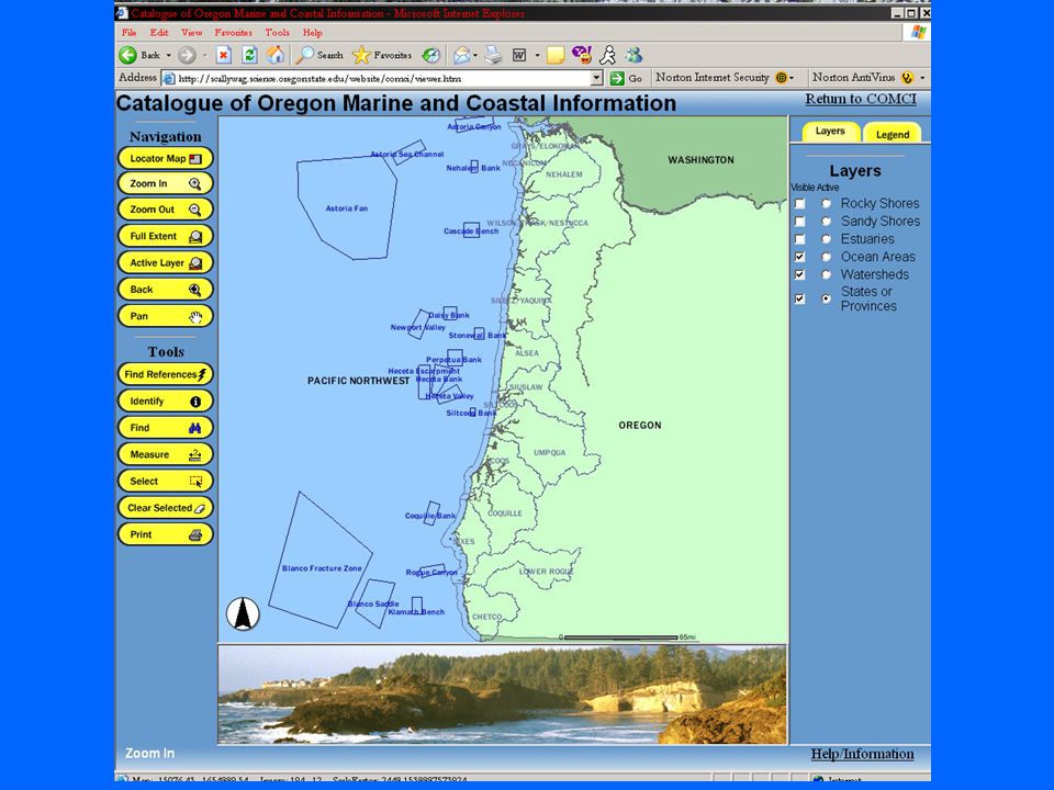
Building an ArcIMS site for COMCI ArcIMS is a web mapping service that uses dynamic maps to deliver data to a wide range of clients and users Adding geographic scope to the database and creating shapefiles Uses Oregon Coastal Atlas location sites plus larger scale regions

9
Active Server Pages (ASP) were created to access the COMCI database and return results through the web server A Find References Tool was created using built-in hyper-linking functions of ArcIMS to retrieve COMCI records from the map Building an ArcIMS site for COMCI
 were created to access the COMCI database and return results through the web server A Find References Tool was created using built-in hyper-linking functions of ArcIMS to retrieve COMCI records from the map Building an ArcIMS site for COMCI")
10
Using the Find References Tool Lower Columbia R

11
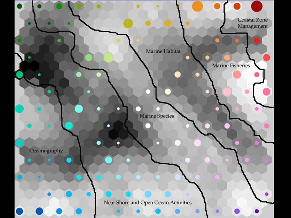
Creating a SOM visualization in GeoVista Studio Needed to visualize all COMCI records Format COMCI data into a comma delimited file –Number range developed for increasing generality in geographic scope Create a shapefile with a polygon for each COMCI record

12
Creating a SOM visualization in GeoVista Load the shapefile and formatted COMCI database file in GeoVista Studio’s data mining design Used specific theme, major subject group, and geographic scope attributes for visualization Begin SOM training Use Parallel Coordinate Plot (PCP) in conjunction with the shapefile to interpret SOM visualization
 in conjunction with the shapefile to interpret SOM visualization")
15
Using Flash Highly interactive environment can be created Easy to implement graphical elements Cartographic principles can be utilized Aesthetically pleasing display combined with high interactivity can result in more acceptable and usable products (Cartwright et al, 2001)
")
16
Results Using interactive map interfaces allows the user to focus in on his/her interest area while at the same time being able to see what areas are in the proximity and the scope of the area itself Using ASP for connecting the web applications to the COMCI database is an efficient method of querying and retrieval –No need to update ArcIMS

18
Discussion Traditional map services are efficient means of disseminating map metaphors and can be directly linked to databases using ASP Interpreting a SOM representation still requires intensive manual interaction As innate geographic sense is important, users must be aware of the map layout’s dependency on the spatialization routine used

19
Conclusion Using the map metaphor allows the user to see the entire database Serving spatial visualizations over the World Wide Web by way of map services increases access to advanced exploratory techniques like Self Organizing Maps Ultimately, the goal of COMCI is to provide policymakers and resource managers, with information needed to evaluate and reassess coastal and ocean management strategies

20
Acknowledgements Many thanks to Tanya Haddad of the state of Oregon Ocean-Coastal Management Program for excellent technical assistance during various stages of this project. We are indebted also to the original coordination of Jane Lubchenco and Jim Good in offering the original Marine Resource Management course at OSU that gave rise to Marine Resource Management course at OSU that gave rise to COMCI. Heather Leslie, Brooke Simler, Renee-Davis Born, Anne COMCI. Heather Leslie, Brooke Simler, Renee-Davis Born, Anne Guerry, and Laura Opsommer of PISCO, and Joe Hanus and Sherry Pittam of the Northwest Alliance for Computational Science and Pittam of the Northwest Alliance for Computational Science and Engineering. Thanks also to Danielle Pattison and Chris Zanger of OSU. Cartwright, W., Crampton, J., Gartner, G., Miller, S., Mitchell, K., Siekierska, E., and Wood, J. (2001). Geospatial Information Visualization User Interface Issues. Cartography and Geographic Information Science, vol. 28, no. 1: 45-60. Fabrikant, S.I. and Buttenfield, B.P. (2001). Formalizing Semantic Spaces for Information Access. Annals of the Association of American Geographers, vol. 91, no. 2: 263-280. Works Cited
. Geospatial Information Visualization User Interface Issues. Cartography and Geographic Information Science, vol. 28, no. 1: Fabrikant, S.I. and Buttenfield, B.P. (2001). Formalizing Semantic Spaces for Information Access. Annals of the Association of American Geographers, vol. 91, no. 2: Works Cited.")
Similar presentations


 has the ability to store, retrieve, manipulate and analyse a range of spatially related.>")


 FGDC Marine & Coastal.>")
