Download presentation
Presentation is loading. Please wait.

1
SCHOOL MAPPI NG PRESENTATION BY SATISH GIROTRA Senior Consultant, TSG, EDCIL

2
Usually as ad when any project or Institution or school is Planned/ built, the first requirement is to prepare a layout plan/ site plan, showing the existing structure, tress, or any component & then orientate the school and allied infrastructure. This is necessary to locate the school building & others components at appropriate and suitable locations, leaving sufficient spaces for parking, playground, assembly site, future expansion etc. Such exercise is essential to orientate the building in such a way that it has proper ventilation, sun, aesthetic, cross ventilation, avoiding glare on the black board etc and to avoid haphazard growth in future.

3
Most of the school constructed so far have not gone through the essential technical exercise which is mandatory and is carried out by all engineering department when ever any project is under taken. This exercise is required for:- For existing schools under SSA a. For all new schools. - School mapping in developed countries has become an important document and professional firms are given the task to prepare school mapping wherever it has not been prepared at the initial stage Why school mapping is required now:-

4
-In developed countries the special tools, equipment are used for school mapping. The tools and equipment used are as follow. -Project toolkit Animation & Graphics Audio & Video Computer Aided Design Database & software - Geospatial Technologies ESRI ArcGIS Intergraph GeoMedia GPS

5
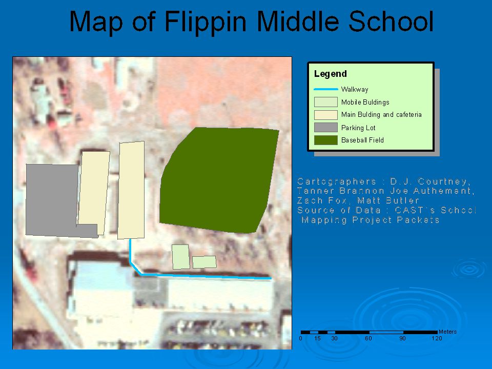
Some of the such school maps prepared with above mention tool kits and technologies are shown.

10
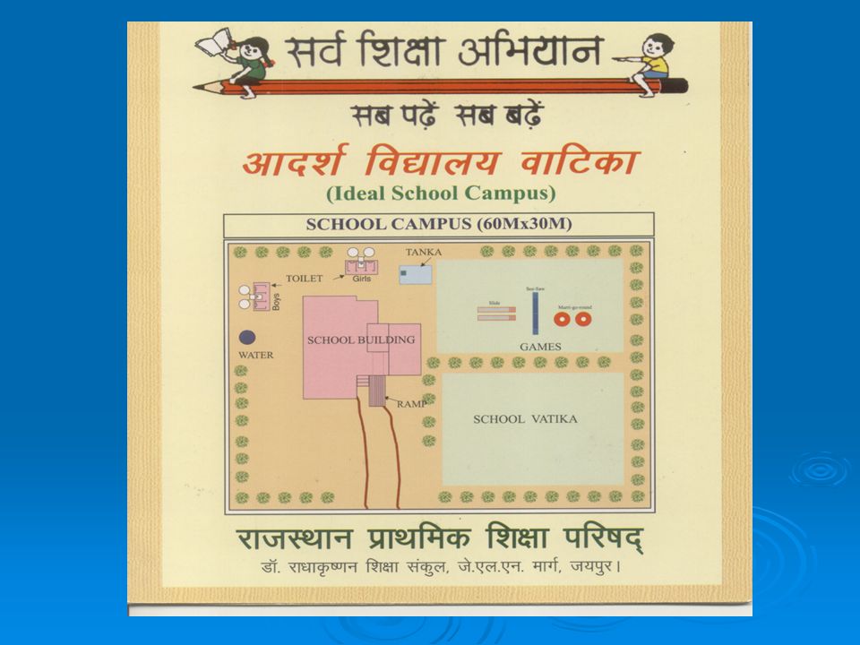
In India too under SSA, attempts have been made to prepare model school campus by some SSA States. one such map prepared by Rajasthan SSA is shown.

12
In India wherever schools in urban/ rural areas are constructed by engineering department like PWD on an ear marked site, necessary mapping/layout plan has been prepared before the construction is taken up. However the school constructed in rural areas by community, PRI, in unplanned colonies slums, generally the layout plan/school mapping is missing

13
Since inception of SSA more than 2.1 lakh primary, upper primary schools and 8.12 lakhs classrooms have been constructed or in progress. In addition to above, school infrastructure has also been added through various schemes like PMGY, MLA, MP funds, State government funds, funds from Finance Commission and through community including other sources. More than 75,000 upper primary school 20,000 primary schools and about 5,00000 classrooms are yet to be added from 2008-09 onward. Contd.

14
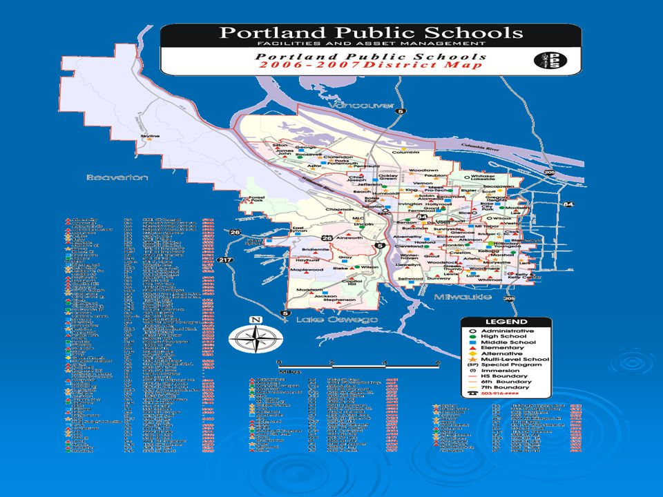
Hence need for school mapping for new construction is dire necessity. Delhi State has done school mapping using Global Information System (GIS) and Global Positioning System (GPS). In such cases school has been marked on geographical map and State is in position to know where the schools are located and where they need more schools. Such mapping help the planner to work out position of new school as and when required. Example of GPS is
 and Global Positioning System (GPS). In such cases school has been marked on geographical map and State is in position to know where the schools are located and where they need more schools. Such mapping help the planner to work out position of new school as and when required. Example of GPS is.")
16
Tamilnadu:- Has also done school mapping as has been done by Delhi for working out the requirement for un served habitations. Actually we are looking for school mapping of each and individual school which have already been constructed or which are likely to be constructed Actually we are looking for school mapping of each and individual school which have already been constructed or which are likely to be constructed

17
School mapping for new school Following inputs are require :- a. Location (name of the village,street,area etc.). b. Boundary of the campus with North direction and showing all roads pathway leading to school site. c. All existing land mark including tress, any tube well, any boundary wall or any other structure existing at site. d. Orientate the new building to be constructed.
. b. Boundary of the campus with North direction and showing all roads pathway leading to school site. c. All existing land mark including tress, any tube well, any boundary wall or any other structure existing at site. d. Orientate the new building to be constructed..")
18
Contd. e. Including position of trees, kitchen shed, child friendly elements, BALA element, anganwadi, toilet, drinking water facilities, gardening areas, assembly areas, parking, position of gate and any other components to be constructed. The map should show future expansion as well. f. Any important land mark near the proposed school

19
Contd. g. Data regarding tentative strength of school children, class wise, population of the locality, rate of growth of population, out of school children between 6 to 14 years teachers Strength, available feeder school. Other details will be :- i. Name of the school. ii. Name of the locality. iii. Name of the block. iv. Name of the districts

20
In addition whether school will be having electricity. In addition whether school will be having electricity. it is in tribal, non tribal, urban or rural areas. it is in tribal, non tribal, urban or rural areas.

21
School mapping of existing schools. Prepare layout plan/ site plan showing the following:- a) Exact boundary of the campus with North direction showing all roads, paths and any important land mark near by. b) Show all existing components such as school building, ramp if any school gate, path leading to school building, kitchen shed, Anganwadi, toilet, drinking water, soakage pit, garden areas, child friendly element, including trees.
 Exact boundary of the campus with North direction showing all roads, paths and any important land mark near by. b) Show all existing components such as school building, ramp if any school gate, path leading to school building, kitchen shed, Anganwadi, toilet, drinking water, soakage pit, garden areas, child friendly element, including trees..")
22
Contd. c. Architectural plan of the existing building showing the type of the building and condition of each classroom (foundation, walling, roofing, flooring, door windows etc.) d. Comparison with SSA norms of the above plan and any new infrastructure required. e. Class wise enrolment disintegrated to boys and girls. f. Number of classes. g. Number of out of school children. h. Population growth and growth of children 6-14 years
 d. Comparison with SSA norms of the above plan and any new infrastructure required. e. Class wise enrolment disintegrated to boys and girls. f. Number of classes. g. Number of out of school children. h. Population growth and growth of children 6-14 years.")
23
Contd. i. Whether school is having electricity. j. Is it in tribal, non tribal, rural or urban area. k. Any classroom which is unsafe. l. Deficiency in infrastructure in accordance with present strength and in accordance SSA norms. m. Four color photographs of front, rear, right and left view of the existing buildings. n. Any other requirement / information.

24
Software Software of school mapping will be developed and data will be stored duly compiled for each school at block, district and State level. In addition to above school map will be prepared for each school on A4 size paper, which will be displayed duly framed in the head master room for future reference and planning. Once this data is prepared this will serve as asset register and shall deter the local people to encroach upon school land.

25
Contd. State can think and prepared school mapping with any such means, tools, equipment which can serve the required purpose. Gujrat State has prepared school mapping through contract and also prepared terms of reference (TOR) for the contract. The same can be referred with reference to State context.
 for the contract. The same can be referred with reference to State context..")
26
THANKS

Similar presentations


 HYDERABAD. Web–enabled school mapping helps to Identify habitations without access to schooling facilities. Conduct proximity.>")
 HHHHaryana KKKKarnataka MMMMaharashtra.>")


 State:DELHI S. No.Activities Targets till date (Units) Cumulative Completed (Units) Cumulative In Progress (Units)>")


Ltd t/a NORTHERN GATEWAY CITY PORTION 2 OF 36-NQ>")
 ANNUAL WORK PLAN & BUDGET 2015-16 DEPARTMENT OF SCHOOL EDUCATION GOVERNMENT OF TELANGANA HYDERABAD.>")


