Download presentation
Presentation is loading. Please wait.

1
ISO Standards and the Australian Spatial Data Infrastructure Andrew Jones Australia

2
AUSTRALIA – PRE-1901 Until 1901, a grouping of British colonies rather than a single nation. Different defense forces Different railway gauges Border Posts Etc

3
AUSTRALIA – POST 1901 Federation in 1901 Areas of common interest referred to the Federal Government Land Administration was retained by the States Eight jurisdictions responsible for land administration

4
Jurisdictional LIS Each jurisdiction has its own computer- based land administration system –Textual Component - Owner and Valuation –Spatial Component - Digital Cadastral Mostly only used within parent jurisdiction Major data models for each system component

5
National Projects Data sub-sets need to be bought together for national projects Problems –Different legislative frameworks –Different terminology –Different conventions –Different data models

6
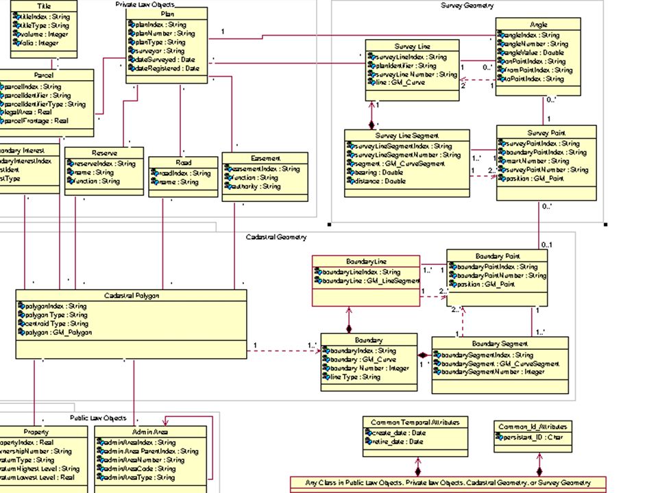
National Cadastral Data Model Developed by ICSM during 1996/97. Published on ICSM’s Web Site. Provided a model for the transfer of parcel- based data. Is suitable for database implementation. Provided a dictionary for common terminology

7
Updating to ISO 19100 Data Model in UML (ISO 19103) Uniform Geometry Description (ISO 19107) Uniform Date/Time Descriptions (ISO 19108) Consistency in Application Schema (ISO 19109) Feature Catalogue (ISO 19110) Metadata (ISO 19115) Encoding in XML (ISO 19118)
 Uniform Geometry Description (ISO 19107) Uniform Date/Time Descriptions (ISO 19108) Consistency in Application Schema (ISO 19109) Feature Catalogue (ISO 19110) Metadata (ISO 19115) Encoding in XML (ISO 19118)")
8
Data Model UML Conceptual Model Implementation Model for Databases –Include Association Classes

10
Feature Catalogue Seeking to comply with ISO 19110 Developed as Access Data Base –Easy to distribute –Allows reports to be produced –Assists data management Can include other data themes

12
Encoding Following ISO 19118 as far as possible Encoding standard is not yet stable XML Schema and DTD are being developed in parallel with the data model and feature catalogue Trial implementation between two jurisdictions later this year

13
XML Schema, XML DTD

14
Spatial Data Infrastructure Institutional Framework Standards and Specifications Fundamental Datasets Clearinghouse

15
Harmonising With Other Themes Themes –Cadastre, Topography, Place Names, Street Address –Traditionally have had a ‘silo’ mentality to data. –Each data model has been developed individually All data sets have certain common characteristics –Persistent identifiers –Create and retire dates –Feature level metadata –Geometric primitives

17
Lessons Need for an integrated approach –Document decisions –Tackle data model, feature catalogue and encoding simultaneously if possible One size does not fit all –Application - data transfer?, data storage? –High-level conceptual model with specific implementation models –Issue when harmonising themes

Similar presentations


 ISO/TC211 Workshop on Standards in Action Adelaide, South Australia October 2001 Mr. Neil Sandercock, SA.>")


