Download presentation
Presentation is loading. Please wait.

1
Impacts of Development on the Gulf Intracoastal Waterway: A Case Study in Alabama Dean Goodin, Ph.D. Eric Dohner Kristin Sutherlin Tetra Tech, Inc.

2
Introduction Coastal Alabama was heavily impacted by Hurricane Ivan (2004) Landfall at Gulf Shores and Orange Beach Category 3 with 130 mph winds
 Landfall at Gulf Shores and Orange Beach Category 3 with 130 mph winds")
3
BeforeAfter

4
BeforeAfter

5
Highway 182 (Perdido Beach Blvd)
")
6
Introduction Coastal Alabama was also impacted by Hurricane Katrina (2005) 67 mph sustained winds Storm surge of 10 feet
 67 mph sustained winds Storm surge of 10 feet")
7
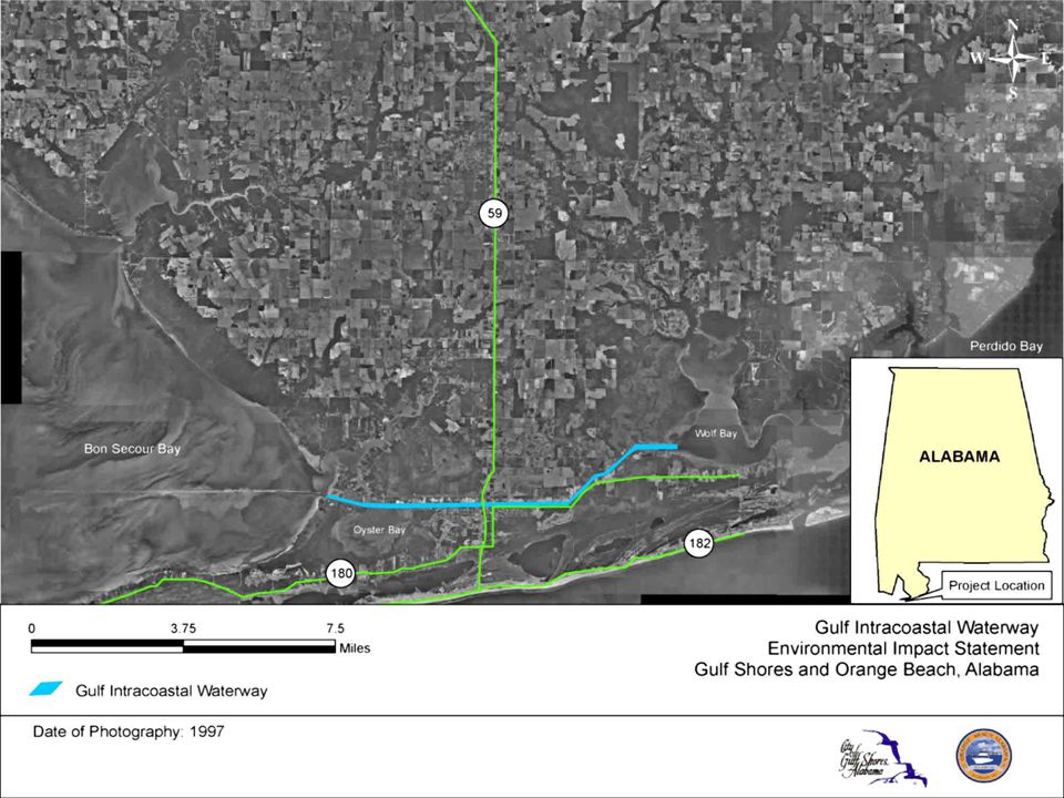
Introduction New development trend in northern Gulf Coast is construction along the Gulf Intracoastal Waterway (GIWW) Threat of tropical storms Escalating prices of beachfront property GIWW extends from Brownsville, TX to Apalachee Bay, FL 520 miles – open bays or coastal sounds 780 miles – man-made canals
 Threat of tropical storms Escalating prices of beachfront property GIWW extends from Brownsville, TX to Apalachee Bay, FL 520 miles – open bays or coastal sounds 780 miles – man-made canals")
8
Gulf Intracoastal Waterway

9
Foley Land Cut In coastal Alabama, the Foley Land Cut is poised for development 10-mile stretch of GIWW in Gulf Shores and Orange Beach Located approximately 2 miles inland Authorized channel dimensions 125 feet wide 12 feet deep Maintained by Corps of Engineers for commercial barge traffic operations

12
Foley Land Cut North Shore East Oyster Bay North Shore West

13
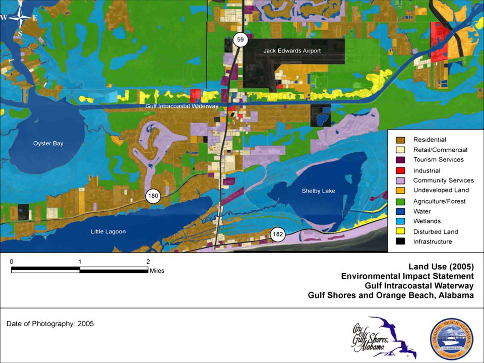
Foley Land Cut Gulf Shores/Orange Beach region being developed and marketed as a tourist destination From 1990 to 2000 permanent population increased 50% Gulf Shores 68% Orange Beach Seasonal population expected to increase 30% by 2008

14
Foley Land Cut Why FLC? Sheltered from tropical storms Available waterfront property Provides waterway access to Gulf of Mexico via Bon Secour Bay and Wolf Bay Existing development Condominiums/single-family homes Marinas Restaurant Commercial

16
Lulu’s Homeport Marina Sailboat Bay Marina Reynold’s Ready Mix The Wharf

18
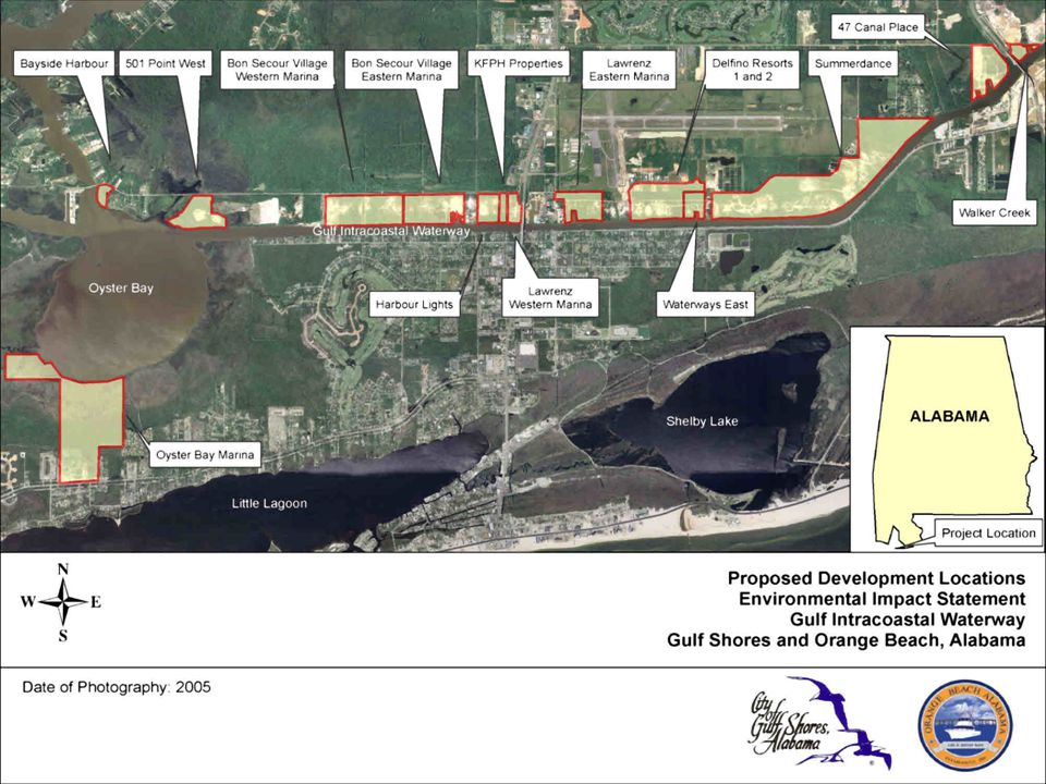
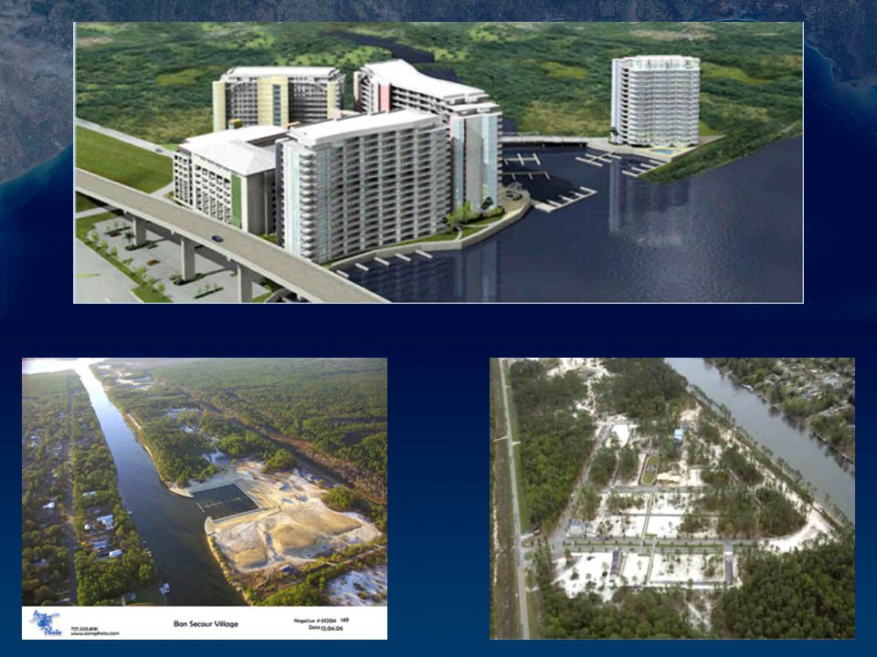
Proposed Development 15 proposed developments on FLC 14 located on north shore of FLC 1 located on south shore of Oyster Bay 16,700 condo units 3591 boat slips 1849 wet slips 1742 dry slips Marinas Retail shopping Office space Amenities (pools, greenspace, boardwalks)
")
20
DevelopmentSizeBoat SlipsCondominiums UnitsRetail/CommercialGreenspace (acres)WetDryPermanentSeasonal(square feet)(acres) 47 Canal Place31270308370905-- 501 Point West378280340797-18.5 Bayside Harbour8116-3581-4.7 Bon Secour Village Eastern Marina510528---- Bon Secour Village West1000107-3,000 750,000500 Delfino Resort 12653-14557925,00010.4 Delfino Resort 21250-8032030,0004.8 Harbour Lights Marina1676-170 25,000- KFPH Properties550-100 20,000- Lawrenz Eastern Marina3777-750500700,0001.85 Lawrenz Western Marina843-173115-0.84 Oyster Bay Marina205396-500 7,000155 Summerdance2404138261048212727,000100 Walker Creek1062-155316-- Waterways East1244-92200-10 TOTAL165218491742695897101,584,000806.09 Proposed Development
WetDryPermanentSeasonal(square feet)(acres) 47 Canal Place Point West Bayside Harbour Bon Secour Village Eastern Marina Bon Secour Village West , , Delfino Resort , Delfino Resort , Harbour Lights Marina ,000- KFPH Properties ,000- Lawrenz Eastern Marina , Lawrenz Western Marina Oyster Bay Marina , Summerdance , Walker Creek Waterways East TOTAL ,584, Proposed Development")
23
EIS Environmental Impact Statement (EIS) Evaluate environmental and socioeconomic consequences of development Address potential impacts to FLC and surrounding communities Waterway Capacity Study Hurricane Evacuation Study
 Evaluate environmental and socioeconomic consequences of development Address potential impacts to FLC and surrounding communities Waterway Capacity Study Hurricane Evacuation Study")
24
EIS Direct and indirect impacts Short-term and long-term impacts Cumulative impacts Mitigation of impacts Irreversible and irretrievable commitment of resources Alternatives to proposed actions

25
EIS Cultural Resources Threatened & Endangered Species Wetlands Fish & Wildlife Resources Vegetative Communities Water Quality Soils & Geology Land Use Recreation Resources Utilities Air Quality Noise Light Socioeconomic Resources Traffic & Transportation Hazardous & Toxic Materials

26
EIS Issues Identified Throughout Scoping Infrastructure impacts Socioeconomic impacts Waterway capacity Biological and natural resources Water quality Environmental impacts Hurricane evacuation

27
Waterway Capacity Study Federally authorized use for commercial traffic Recreational use must not impact present and future commercial operations Safety and navigation concerns Speeding Uneducated boaters Congestion in high use areas (Hwy 59 boat ramp, Lulu’s, bridges, etc.)
")
28
Lulu’s Homeport MarinaHighway 59 Bridge Public Boat Ramp Bon Secour Village MarinaThe Wharf Marina

29
Hurricane Evacuation Study Impacts of proposed developments Increased population of permanent and seasonal residents Increased number of vehicles Infrastructure Evacuation routes Vessel evacuation and security plan Shelters

31
Socioeconomic Analysis Impacts of proposed developments Housing Employment Schools Evaluate Labor force capacity Availability of affordable housing Public services Existing educational facilities Regional transportation

32
Biological & Natural Resources Wildlife and fisheries Habitat Species population/diversity Threatened and endangered species Nesting sea turtles Light pollution impacts Wetlands

34
Other Resource Areas Infrastructure Utilities Transportation network Water quality Fuel dispensing facilities Stormwater runoff Debris (recreational users, hurricanes) Recreation Public/private boat launches Ecotourism
 Recreation Public/private boat launches Ecotourism")
35
In Closing EIS to provide an objective evaluation of impacts associated with the proposed actions EIS will provide an example for future development along GIWW and Gulf Coast Florida St. Joe Land Company (Apalachicola Bay) Texas Port O’Connor (Dolphin Point Community)
 Texas Port O’Connor (Dolphin Point Community).")
36
Questions?

Similar presentations


>")


 on NC 12 over Oregon Inlet TIP Project No. B-2500 Citizens Informational Workshops.>")


: Environmental and Economic Implications Coastal Wetland Planning, Preservation, and Restoration Act.>")