Download presentation
Presentation is loading. Please wait.

1
Georgia’s Waterways Chapter 2 Section 3: This Place We Call Home SS8G2
(a, b) ~waterways~
 ~waterways~")
2
Words to know… -- Atlantic Intracoastal Waterway -- Semidiurnal tides -- Estuaries -- Reservoir -- Aquifer

3
Atlantic Intracoastal Waterway
1,000-mile inland waterway that runs from New York to Miami, Florida Between Georgia’s barrier islands and the Georgia coast gives commercial and recreational boating traffic safety from storms, strong currents, and waves of ocean routes. Savannah and Brunswick are Georgia’s two deep water ports

4
Atlantic Intracoastal Waterway

5
Georgia’s Tides A tide is a rise or fall of the sea level caused
by gravitational pull of the sun and the moon Georgia’s coastline has six-foot to 9-foot tides (unusual) Georgia has semidiurnal tides (two high tides and two low tides daily) Spring tides (tides at highest) and neap tides (tides at their lowest)
 Georgia has semidiurnal tides (two high tides. and two low tides daily) Spring tides (tides at highest) and neap tides. (tides at their lowest)")
6
Coastal Waterways: The Saltwater Marshes
Four- to six-mile band of saltwater marshes are between barrier islands and the mainland These marshes cover about 500,000 acres Cordgrass makes up 95 percent of the saltwater marsh vegetation Sand fiddlers, mud fiddlers, snails, and crabs are common

7
Coastal Waterways: Sloughs and Estuaries
Freshwater sloughs (pronounced “slaws”) are small ponds, swamps, and freshwater marshes Develop from marsh creeks that lose tidal flow Provides fresh water for forest animals Estuaries occur when freshwater rivers and salt water mix; include tidal rivers, sounds, and marsh creeks Crab, shrimp, fish, and shellfish thrive in these waters
 are small ponds, swamps, and freshwater marshes. Develop from marsh creeks that lose tidal flow. Provides fresh water for forest animals. Estuaries occur when freshwater rivers and salt water mix; include tidal rivers, sounds, and marsh creeks. Crab, shrimp, fish, and shellfish thrive in these waters.")
8
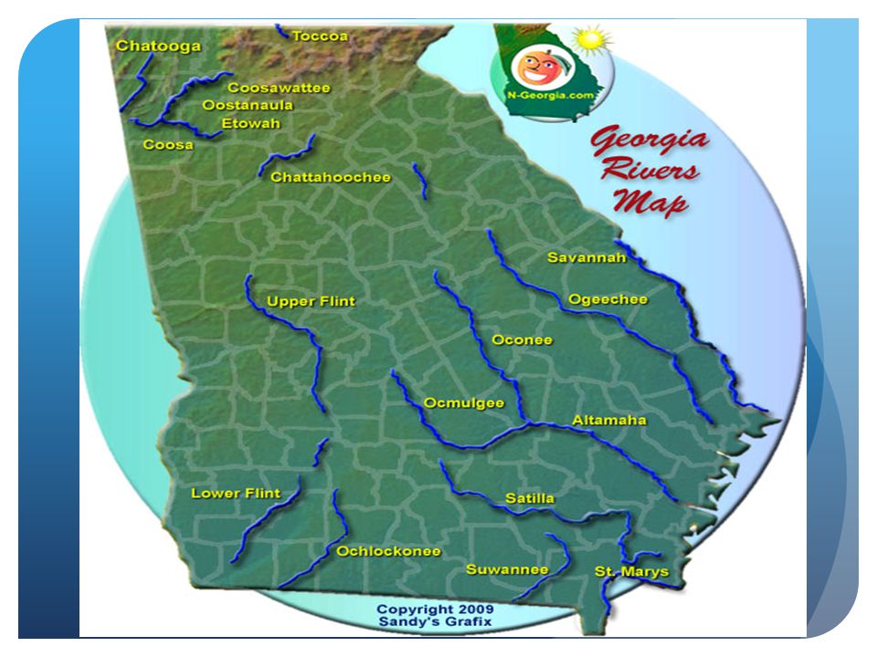
Georgia’s Rivers Twelve principal river systems
Savannah, Ogeechee, Altamaha (which combines Oconee and Ocmulgee), and Satilla rivers flow into Atlantic Ocean Chattahoochee and Flint rivers become part of Gulf of Mexico Oostanaula and Etowah rivers form the Coosa River, which flows through Alabama to the Gulf. Alapaha, Suwannee, and St. Mary’s form the Georgia- Florida border
, and Satilla rivers flow into Atlantic Ocean. Chattahoochee and Flint rivers become part of Gulf of Mexico. Oostanaula and Etowah rivers form the Coosa River, which flows through Alabama to the Gulf. Alapaha, Suwannee, and St. Mary’s form the Georgia- Florida border.")
10
Georgia’s Lakes No large natural lakes, but network of lakes formed from river system Many large lakes created by U.S. Corps of Engineers and the Georgia Power Company Carter Lake, Lake Lanier, Walter George, West Point, and Seminole generate hydroelectric power Thurmond Lake, Lake Oconee, and Lake Hartwell provide fishing, recreation, and boating opportunities

13
Georgia’s Ports Bainbridge and Columbus harbor two inland barge terminals Savannah’s port, the nation’s fifth largest container port, focuses on containerized cargo Brunswick’s port handles auto shipping, heavy equipment, farm machinery, and luxury tour buses

14
Reservoirs and Aquifers
Little groundwater in northern half of Georgia Manmade Reservoirs (holding tanks) provide much water for northern Georgia Georgia major aquifers (natural water storage tanks) are in Coastal Plain Augusta features a nine-mile canal; today it is a National Park Heritage Area
 provide much water for northern Georgia. Georgia major aquifers (natural water storage tanks) are in Coastal Plain. Augusta features a nine-mile canal; today it is a National Park Heritage Area.")
15
(North Georgia’s largest reservoir)
Lake Lanier (North Georgia’s largest reservoir)
")
Similar presentations


>")