Download presentation
Presentation is loading. Please wait.

1
Geologic History of N. America

2
Mesozoic Era The terrains of California are visible in the west. These were added to the coast as we overran the Farallon plate later on. The Appalachians are visible on the east coast of the continent.

3
Mesozoic Era 115 million years ago 75 million years ago

4
Cretaceous Inland Sea During the Cretaceous period, 90 million years ago, an inland sea formed in the center of the country. It was later filled in from sediment from the erosion of the Rockies on the west, Appalachians on the east.

5
Cenozoic Era 65 million years ago 8 million years ago

6
20,000 years ago The last ice age ended 10,000 years ago. The ice had advanced into much of the north and eastern United States. Glaciers also existed in the mountainous regions of the West.

7
Present Day As the glaciers retreated, they carved out huge depressions now called the Great Lakes. The Great Lakes hold 1/5 of the world’s freshwater reserves.

8
Geologic History of the Southwest USA

9
Sedimentary layers As you watch these pictures change, notice how the sediment changes. – Mud will solidify into shale – Water drops organisms which will solidify into limestone – Sand will solidify into sandstone These are the layers you see in the Grand Canyon; a visual history of Arizona’s past.

10
Proterozoic Eon – 2000 mya Mid Proterozoic Eon Late Proterozoic Eon

11
Cambrian Period 510 mya

12
Kartchner Caverns Underground caverns are formed in limestone which is deposited when an area is covered by shallow seas. We can see in the previous and following diagrams that Arizona has been under water in the past.

13
Paleozoic Era Ordovician Period - 470 mya Silurian Period – 430 mya

14
Paleozoic Era Permian Period – 270 myaPennsylvanian Period 300 mya

15
Permian Extinction The Permian period was the last in the Paleozoic Era. At the end of the Permian period, 95% of all species on Earth disappeared. Scientists are not sure why.

16
Mesozoic Era Triassic Period 240 mya Late Triassic Period 220 mya

17
Mesozoic Era Jurassic Period – 200 myaLate Jurassic period – 145 mya

18
Mesozoic Era Late Jurassic – 145 myaEarly Cretaceous Period 130 mya

19
Mesozoic Era Early Cretaceous period 130 mya Cretaceous Tertiary boundary 65 mya

20
Cenozoic Era Mid Tertiary period – 35 mya (Eocene Epoch) Tertiary period 50 mya (Eocene Epoch)
 Tertiary period 50 mya (Eocene Epoch)")
21
Cenozoic Era Miocene epoch 18 mya Uplift of the Colorado Plateau 18 million years ago. The uplift created the Grand Canyon, the Petrified Forest, the Mogollom Rim and the parks of Utah (Zion, Bryce and Canyonlands)
.")
22
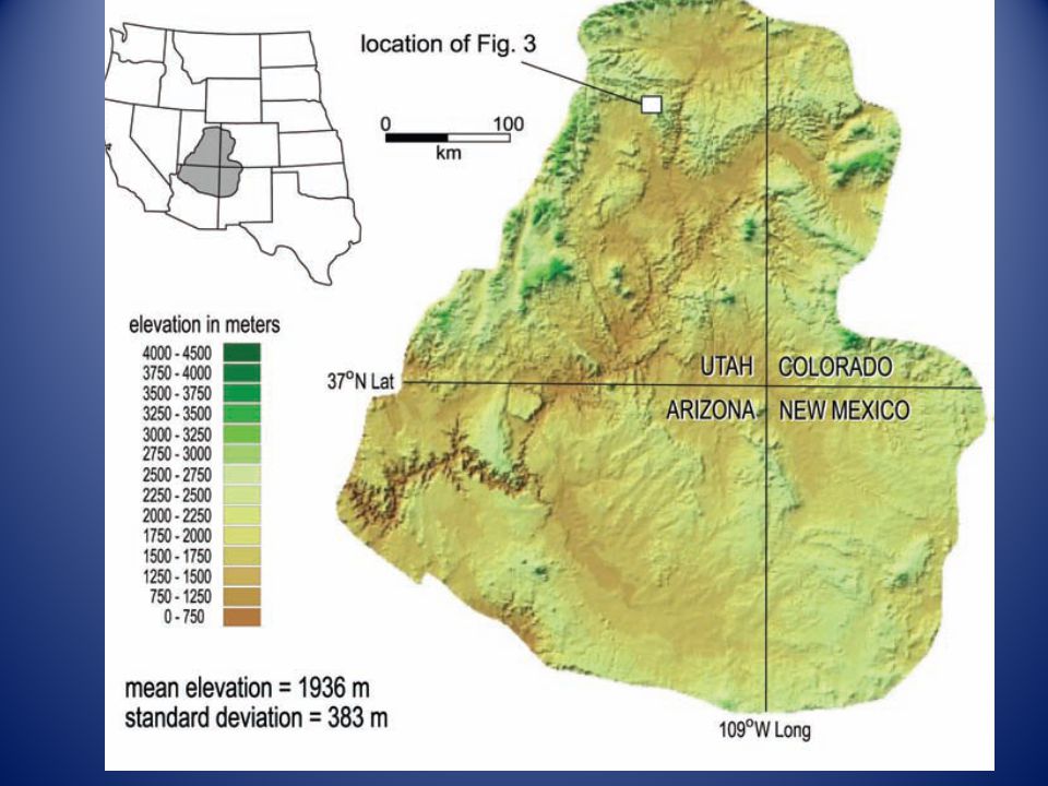
Colorado Plateau The Colorado Plateau covers a large part of the Southwest U.S. The uplift caused rivers to reverse course, mountains to form and canyons to be created.

25
Colorado Plateau in Arizona The uplift of the Colorado Plateau is the single biggest event that shaped Arizona as we know it today. Arizona now has three distinct areas; the low deserts, the Rim country and the plateau or higher elevation area

26
Grand Canyon: formed by uplift and erosion

27
Grand Canyon The Colorado River began to flow to the west during the uplift. The river was able to cut through the rising land quickly; much quicker than if the land was not lifting underneath it. The Canyon formed in 6 million years which is very fast in geologic terms.

28
Mogollom Rim The Mogollom Rim is the edge of the Colorado Plateau. We are driving up the edge of the plateau when we drive up to Payson or Prescott. ( )
.")
29
Petrified Forest A large lake existed in eastern Arizona. The uplift of the Colorado Plateau caused the lake to spill and flow to the west cutting the Grand Canyon. The leftover swamp water replaced the plant cells in trees as the swamp slowly dried up.

Similar presentations


>")

