Download presentation
Presentation is loading. Please wait.

1
Chapter 3 Section 2 Water Erosion

2
Water Cycle Watch the 2 water cycle animations while reviewing your water cycle diagram. When something from your diagram is discussed or shown put a If you are missing something, make a note of it on your diagram.

3
Water Cycle

4
Water Cycle

5
SURFACE WATER RIVERS (RUNOFF)
")
6
Raindrop Erosion

7
Raindrop Erosion The force of a falling raindrop can loosen and pick up soil particles. This starts the process of erosion.

8
RIVER EROSION

9
Why is runoff so important to erosion?
As water moves over land it carries particles with it. This moving water is runoff and is the major agent of erosion.

10
5 Factors for the Amount of Runoff:
1. Amount of Rain 2. Vegetation 3. Type of Soil 4. Shape of Land 5. How people use the land

11
Runoff leads to

14
STREAM

15
RIVER

16
T R I B U A Y

17
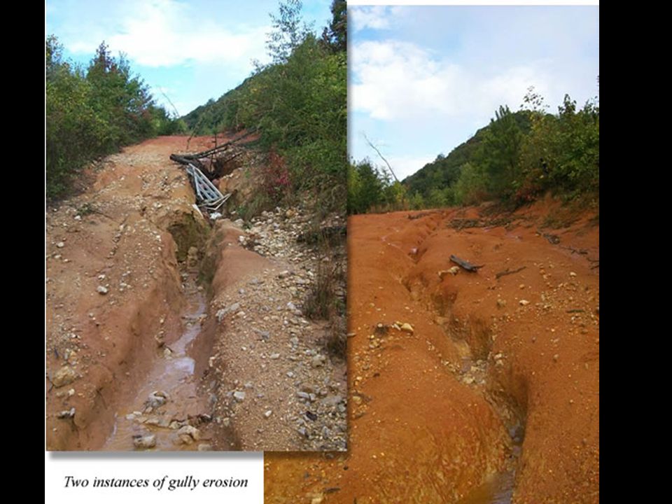
More Runoff = More Erosion
How are rills, gullies, streams, tributaries and rivers connected? Rills are small grooves that runoff creates and travels in the soil. Rills connect together and make larger channels called gullies. Gullies connect together forming larger channels called streams. Streams connect together as larger streams or rivers. (Tributary-any stream/river that flows into a larger one) RillGullyStreamRiver General Statement About Erosion: More Runoff = More Erosion
 RillGullyStreamRiver. General Statement About Erosion: More Runoff = More Erosion.")
18
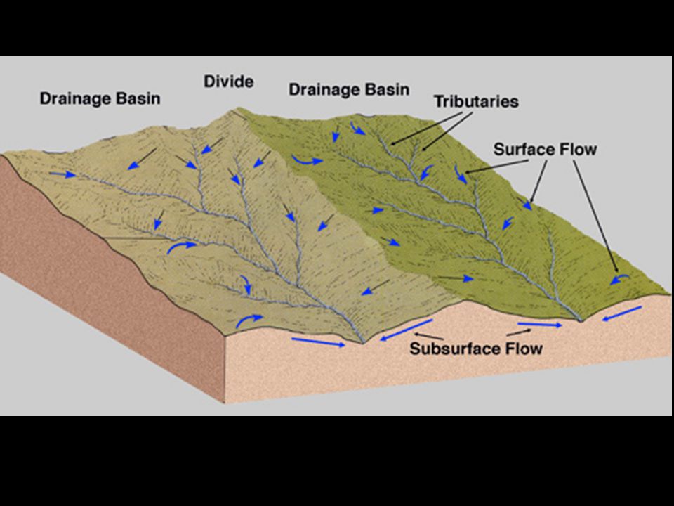
What is a drainage basin or watershed?

21
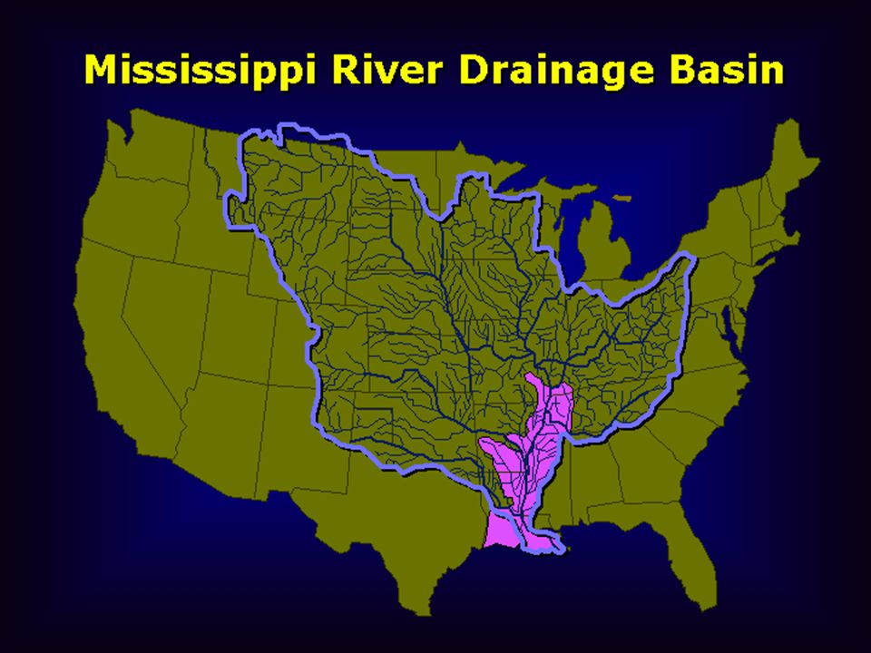
(Largest in US-Mississippi River Drainage Basin)
Parts of a River System:: Drainage basin (watershed)-A land area from which a major river and its tributaries collect its water (Largest in US-Mississippi River Drainage Basin) Divide-An area of the land around a drainage basin where the land is high and causes the water to run into that drainage basin.
-A land area from which a major river and its tributaries collect its water. (Largest in US-Mississippi River Drainage Basin) Divide-An area of the land around a drainage basin where the land is high and causes the water to run into that drainage basin.")
22
VALLEY When a river cuts into a steep slope of a mountain or a flat plateau a V-shape will be cut in the land

23
Where a river meets an area of rock that is very hard and erodes slowly. The rock below is softer and erodes quickly. W A T E R F L

24
W A T E R F L The river water flows over softer rock downstream.
The softer rock wears away faster than the harder rock. Eventually a waterfall develops where the softer rock was removed.

25
Flood Plain An area downriver where the land is gently sloping.
The river will erode a wide, flat area of land instead of a deep valley. When the river floods this land will fill with the excess water.

26
Softer rock eroded away
The moving water of a river will erode softer rock before eroding harder rock. This will cause the river to work its way around harder rock and create loop-like bends in the river. Overtime the bends become more and more curved. M E A N D R Softer rock eroded away Harder rock stays

27
A Meandering River

28
A meander that has been cut off from the main river during a time of flooding.
X B W L A K E

29
O X B W L A K E River flows through meander.
Deposition builds up inside meander curve. O X B W L A K E As the floodwaters drop, sediment builds up in front of the openings of the meander and dam up the water inside forming an oxbow lake. When the river floods, the high water finds a straighter route downstream.

30
RIVER DEPOSITION

31
Water slows when hits gentle slope
ALLUVIAL FAN Water slows when hits gentle slope Where a stream flows out of a steep, narrow mountain valley, the water slows down, drops sediment in the shape of a wide sloping fan. Steep mountain valley Sediment forms fan-shaped deposit

32
Water slows when hits gentle slope
ALLUVIAL FAN Water slows when hits gentle slope

33
D E L T A Mississippi River
Green-land built up from deposition When a river meets the ocean or large lake, the water slows down. The river drops its sediment and can build up new land.

34
River flooding adds soil to flood plain.
When waters rise, deposition occurs in the flood plain. This soil is very fertile.

35
PAUSE HERE FOR NIAGARA FALLS VIDEO

36
GROUNDWATER (Infiltration)
37
Infiltration- Increasing the amount of groundwater through precipitation or surface water that absorbs (or seeps) into the ground
 into the ground")
38
Water easily sinks down into the limestone.
KARST TOPOGRAPHY In regions where a layer of limestone is near the surface, groundwater erosion changes the shape of the land. Water easily sinks down into the limestone. Deep valleys, sinkholes and caverns are common.

39
KARST TOPOGRAPHY Before Rain After Rain

40
Groundwater-underground water causes erosion and deposition.
Water combines with carbon dioxide to make carbonic acid, flows into limestone, dissolves the limestone, and carries the particles away

41
Caves/Caverns- As limestone is dissolved over time large underground holes form

42
STALACTITE STALAGMITE

43
StalaCtite-As limestone particles in the groundwater is deposited on the Ceiling of a cave an icicle of limestone forms StalaGmite-As groundwater drips on the Ground of a cave an upside down icicle of limestone forms

44
SINKHOLE The roof of a cave collapses resulting in a depression.
The cave roof erodes the limestone too thin.

45
Guatemala Sinkhole Feb 24, 2007

46
END HERE FOR WATER’S JOURNEY VIDEO

Similar presentations