Download presentation
Presentation is loading. Please wait.

3
Earth’s Topographic Regions

4
Continental Shields

5
GEOLOGY OF THE USA

7
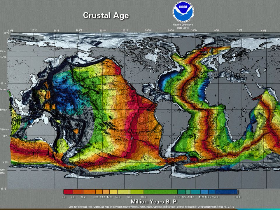
Atlantic Ocean Crustal Ages

8
Clues to Earth’s Surface
Mountains only in certain areas Rock types differ regionally Shields in interior of continents Oceans oldest near continents and youngest towards middle of oceans

9
EARTH’S LAYERS The Earth is divided into three chemical layers:
the core, the mantle and the crust Chemical differences

10
THE CORE The core is composed of mostly iron and nickel and remains very hot, even after 4.5 billion years of cooling. The core is divided into two layers: a solid inner core and a liquid outer core.

11
CORE GENERATES CURRENTS
Because the core is so hot, it radiates a natural heat to the upper layers. Because of this a current of heat comes into being. Those are also known as the convection currents. The convection currents cause the movement of the tectonic plates.

12
MAGNETIC FIELD It is well known that the axis of the magnetic field is tipped with respect to the rotation axis of the Earth. Thus, true north (defined by the direction to the north rotational pole) does not coincide with magnetic north (defined by the direction to the north magnetic pole) and compass directions must be corrected by fixed amounts at given points on the surface of the Earth to yield true directions.
 does not coincide with magnetic north (defined by the direction to the north magnetic pole) and compass directions must be corrected by fixed amounts at given points on the surface of the Earth to yield true directions.")
13
Origin of the Magnetic Field
Magnetic fields are produced by the motion of electrical charges. For example, the magnetic field of a bar magnet results from the motion of negatively charged electrons in the magnet. The origin of the Earth's magnetic field is not completely understood, but is thought to be associated with electrical currents produced by the coupling of convective effects and rotation in the spinning liquid metallic outer core of iron and nickel. This mechanism is termed the dynamo effect.

15
MANTLE and CRUST

16
MANTLE Composed of minerals rich in the elements iron, magnesium, silicon, and oxygen Source of mafic minerals

17
CRUST The crust is rich in the elements oxygen and silicon with lesser amounts of aluminum, iron, magnesium, calcium, potassium, and sodium. Oceanic crust is made of relatively dense rock called basalt Continental crust is made of lower density rocks, such as andesite and granite.

18
LITHOSPHERE The lithosphere (from the Greek, lithos, stone) is the rigid outermost layer made of crust and uppermost mantle The lithosphere is the "plate" of the plate tectonic theory

19
ASTHENOSPHERE The asthenosphere (from the Greek, asthenos, devoid of force) is part of the mantle that flows, a characteristic called plastic behavior. The flow of the asthenosphere is part of mantle convection, which plays an important role in moving lithospheric plates.
 is part of the mantle that flows, a characteristic called plastic behavior. The flow of the asthenosphere is part of mantle convection, which plays an important role in moving lithospheric plates.")
20
CRUST/MANTLE AGAIN lithosphere asthenosphere hard ~100 km thick
crust floats on top continental crust, 20 to 70 km thick oceanic crust, ~ 8 km thick asthenosphere soft ~3000 km thick “fluid-like”

21
ISOSTACIC REBOUND A heavy load on the crust, like an ice cap, large glacial lake, or mountain range, can bend the lithosphere down into the asthenosphere, which can flow out of the way. The load will sink until it is supported by buoyancy. If an ice cap melts or lake dries up due to climatic changes, or a mountain range erodes away, the lithosphere will buoyantly rise back up over thousands of years. This is the process of isostatic rebound.

22
EARTH STRUCTURE SUMMARY
The Earth is sphere with a diameter of about 12,700Kilometres. As we go deeper and deeper into the earth the temperature and pressure rises. The core temperature is believed to be an incredible °c. The crust is very thin (average 20Km). This does not sound very thin but if you were to imagine the Earth as a football, the crust would be about ½millimetre thick. The thinnest parts are under the oceans (OCEANIC CRUST) and go to a depth of roughly 10 kilometres. The thickest parts are the continents (CONTINENTAL CRUST) which extend down to 35 kilometres on average. The continental crust in the Himalayas is some 75 kilometres deep. The mantle is the layer beneath the crust which extends about half way to the centre. It's made of solid rock and behaves like an extremely viscous liquid - (This is the tricky bit... the mantle is a solid which flows????) The convection of heat from the centre of the Earth is what ultimately drives the movement of the tectonic plates and cause mountains to rise. The outer core is the layer beneath the mantle. It is made of liquid iron and nickel. Complex convection currents give rise to a dynamo effect which is responsible for the Earth's magnetic field. The inner core is the bit in the middle!. It is made of solid iron and nickel.
. This does not sound very thin but if you were to imagine the Earth as a football, the crust would be about ½millimetre thick. The thinnest parts are under the oceans (OCEANIC CRUST) and go to a depth of roughly 10 kilometres. The thickest parts are the continents (CONTINENTAL CRUST) which extend down to 35 kilometres on average. The continental crust in the Himalayas is some 75 kilometres deep. The mantle is the layer beneath the crust which extends about half way to the centre. It s made of solid rock and behaves like an extremely viscous liquid - (This is the tricky bit... the mantle is a solid which flows ) The convection of heat from the centre of the Earth is what ultimately drives the movement of the tectonic plates and cause mountains to rise. The outer core is the layer beneath the mantle. It is made of liquid iron and nickel. Complex convection currents give rise to a dynamo effect which is responsible for the Earth s magnetic field. The inner core is the bit in the middle!. It is made of solid iron and nickel.")
23
CONTINENTAL DRIFT Continental drift was originally proposed by Alfred Wegener, a German meteorologist, in 1912. Wegener used his observations to hypothesize that all of the present-day continents were once part of a single supercontinent called Pangaea.

24
ALFRED WEGENER Wegener obtained his doctorate in planetary astronomy in 1905 but soon became interested in meteorology; during his lifetime, he participated in several meteorologic expeditions to Greenland. Died in 1930 during Greenland expedition

25
CD: FOSSIL EVIDENCE Fossils of the same species were found on several different continents. Wegener proposed that the species dispersed when the continents were connected and later carried to their present positions as the continents drifted. For example, Glossopteris, a fern, was found on the continents of South America, Africa, India, and Australia.

26
TORN NEWSPAPER IDEA Rock sequences in South America, Africa, India, Antarctica, and Australia show remarkable similarities. Wegener showed that the same three layers occur at each of these localities. The bottom (oldest) layer is called tillite and is thought to be a glacial deposit. The middle layer is composed of sandstone, shale, and coal beds. Glossopteris fossils are in the bottom and middle layers. The top (youngest) layer is lava flows. The same three layers are in the same order in areas now separated by great distances.
 layer is called tillite and is thought to be a glacial deposit. The middle layer is composed of sandstone, shale, and coal beds. Glossopteris fossils are in the bottom and middle layers. The top (youngest) layer is lava flows. The same three layers are in the same order in areas now separated by great distances.")
27
SHIFTING CLIMATE Using the distribution of rock types, Wegener reconstructed the distribution of climates zones at specific times in the geologic past. He found that, unlike the present distribution, in which zones parallel the equator, the past zones occupied very different positions. This implies that the rotational pole was in very different locations relative to today. Wegener proposed an alternative interpretation. He believed that the climate zones remained stationary and the continents drifted to different locations. The drift of the continents caused the apparent movement of the climate zones.

28
POLAR WANDERING Wegener used the distribution of climate zones to determine the location of the poles at different times in the geologic past. He found that the rotational pole appears to gradually change location, arriving at its present position only in the very recent geologic past. The apparent movement in the pole position over time is called polar wandering. Wegener offered an alternative explanation. He suggested that the poles remained stationary and that the continents changed their positions relative to the poles.

29
ARGUMENTS AGAINST Today we know that it was the right
The greatest shortcoming, at least in the eyes of American geologists, was the lack of an adequate mechanism for moving the continents. Wegener proposed that the Earth's spin caused the continents to move, plowing through the oceanic plate and producing mountains on their leading edges. Geologists at that time understood enough about the strength of rocks to know that this was highly unlikely. Wegener's work was largely unaccepted in the northern hemisphere. In the southern hemisphere, where geologists were familiar with the rocks that Wegener used to support his hypothesis, continental drift was generally accepted. Today we know that it was the right idea for the wrong reasons.

30
Continental Drift Evidence
Puzzle idea: continents fit together Torn newspaper: matching geology Fossils: same fossil on different continent Paleoclimate Polar Wandering Glacial features

31
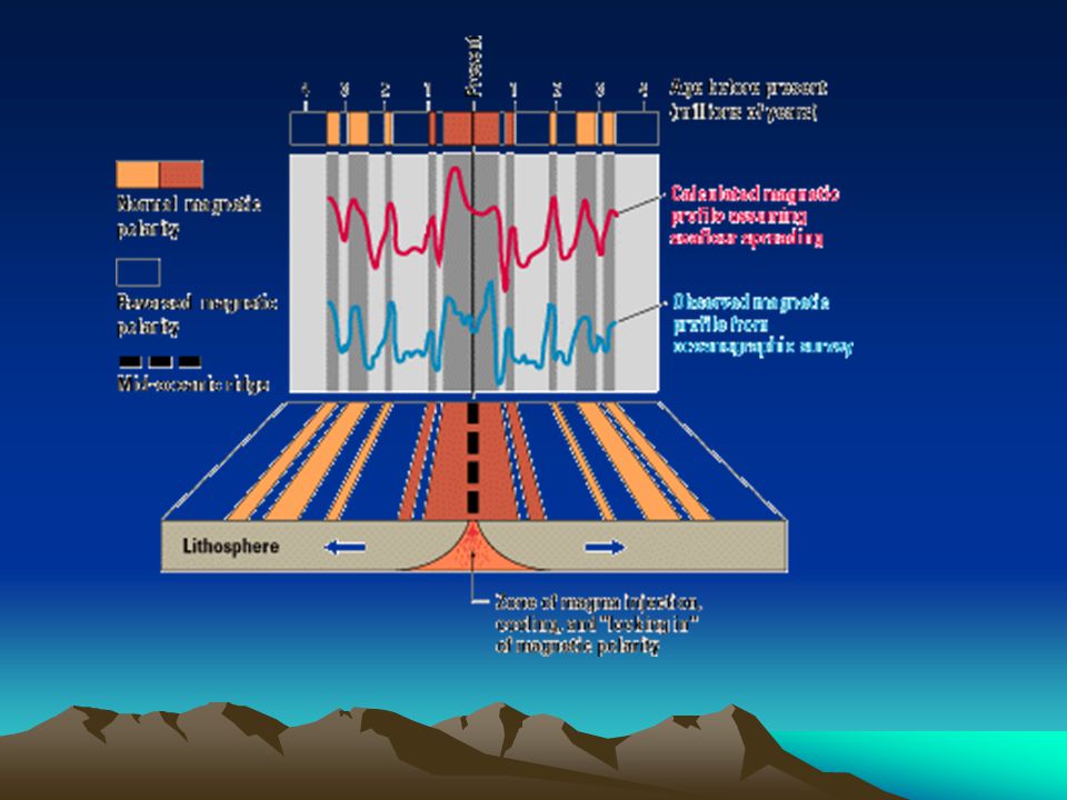
SEA-FLOOR SPREADING: the test
In the late 1950's, scientists mapped the present-day magnetic field generated by rocks on the floor of the Pacific Ocean.

32
SEA FLOOR SPREADING HO When mapped, the anomalies produce a zebra-striped pattern of parallel positive and negative bands. The pattern was centered along, and symmetrical to, the mid-ocean ridge

33
SEA FLOOR SPREADING HO

34
SEA FLOOR SPREADING HO

35
SEA FLOOR SPREADING HO

37
SEA FLOOR SPREADING In 1962, a geologist presented an explanation for the global rift system. Harry Hess proposed that new ocean floor is formed at the rift of mid-ocean ridges. The ocean floor, and the rock beneath it, are produced by magma that rises from deeper levels. Hess suggested that the ocean floor moved laterally away from the ridge and plunged into an oceanic trench along the continental margin.

38
SEA FLOOR SPREADING As Hess formulated his hypothesis, Robert Dietz independently proposed a similar model and called it sea floor spreading. Dietz's model had a significant addition. It assumed the sliding surface was at the base of the lithosphere, not at the base of the crust. Hess and Dietz succeeded where Wegener had failed. Continents are no longer thought to plow through oceanic crust but are considered to be part of plates that move on the soft, plastic asthenosphere. A driving force, convection currents, moved the plates. Technological advances and detailed studies of the ocean floor, both unavailable during Wegener's time, allowed Hess and Dietz to generate the new hypotheses.

39
SEA-FLOOR SUMMARY Vine and Matthews proposed that lava erupted on the sea floor on both sides of the rift, solidified, and moved away before more lava was erupted. If the Earth's magnetic field had reversed (changed from one geographic pole to the other) between the two eruptions, the lava flows would preserve a set of parallel bands with different magnetic properties. The ability of Vine and Matthews' hypothesis to explain the observed pattern of ocean floor magnetic anomalies provided strong support for sea floor spreading.
 between the two eruptions, the lava flows would preserve a set of parallel bands with different magnetic properties. The ability of Vine and Matthews hypothesis to explain the observed pattern of ocean floor magnetic anomalies provided strong support for sea floor spreading.")
40
EARTHQUAKES In 1935, K. Wadati, a Japanese seismologist, showed that earthquakes occurred at greater depths towards the interior of the Asian continent. Earthquakes beneath the Pacific Ocean occurred at shallow depths. Earthquakes beneath Siberia and China occurred at greater depths. After World War II, H. Benioff observed the same distribution of earthquakes but could not offer a plausible explanation.

41
SUBDUCTION If new oceanic lithosphere is created at mid-ocean ridges, where does it go? The movement of oceanic lithosphere away from mid-ocean ridges provides an explanation. Convection cells in the mantle help carry the lithosphere away from the ridge. The lithosphere arrives at the edge of a continent, where it is subducted or sinks into the asthenosphere.

Similar presentations


,>")


