Download presentation
Presentation is loading. Please wait.

1
Limestone

3
Limestone scenery Attermire scar, north Yorkshire
Scars and plateau Limestone scenery Attermire scar, north Yorkshire

5
Plateau

6
Limestone pavement Malham, Yorkshire

8
Malham, Yorkshire

9
Clints and Grykes

10
FORMATION OF LIMESTONE PAVEMENTS

11
Swallow holes

13
Underground features Underground features

17
Re-appearance stream Malham cove

18
Malham cove

19
Dry Valley WATLOWES VALLEY, MALHAMDALE

20
GORDALE SCAR, nr Malham, Yorkshire

21
Dry Valley, Castleton, Derbyshire, Peak District National Park

23
Italian Limestone- the Dolomites

24
Capri

25
Australian limestone

26
Jenolan Caves Just 30km from Oberon, has the most spectacular and best-known Limestone caves in Australia

28
caigana Blow hole nullarbor Australia

29
Limestone in Thailand

31
Limestone in Pang Nga A Famous mark in Pang Nga, deptly named Kui Lin of Thailand

32
Label the diagram of Limestone features
1 Limestone pavement Stalagmite 2 Scarr Pillar 3 Scree Swallow hole 4 Reappearance stream Well jointed rock 5 Cavern Pot hole 6 Stalactite Clints and Grykes Choose from Cavern, Scar, Stalagmite, Limestone plateau, reappearance stream, pot hole, Stalactite, scree, pillar, Swalow hole, clints and grykes, well jointed rock

33
Clints and Grykes Grykes Clints Label the diagram
Describe the main properties of carboniferous limestone A hard white or grey rock. It is pervious but not porous. It is well jointed. It dissolves in weak acid (rain water) 2. Which UK National parks are dominated by limestone scenery? Yorkshire dales and Peak district Describe a carboniferous limestone area. High plateau’s dissected by deep valleys. There is very little vegetation on the high plateau’s and there is exposed limestone pavement. On the edges of the plateau are scarrs (cliffs). At the bottom of these are scree slopes. The valleys are either dry gorges or have rivers running in them. The vegetation is lush around the rivers.
 2. Which UK National parks are dominated by limestone scenery Yorkshire dales and Peak district. Describe a carboniferous limestone area. High plateau’s dissected by deep valleys. There is very little vegetation on the high plateau’s. and there is exposed limestone pavement. On the edges of the plateau are scarrs (cliffs). At the bottom of these are scree slopes. The valleys are either dry gorges or have rivers. running in them. The vegetation is lush around the rivers.")
34
Limestone – Peak district
Swallow hole Label the diagram Cave Dry river bed Boulder clay Dry gorge Shake holes Re-appearance stream Impervious rock Pavement Limestone Impervious rock Definitions Boulder clay Dumped by ice during the ice age Shake holes Boulder clay sinks into hollows as limestone dissolved away Dry Gorge Formed by meltwater at end of last ice age Dry river bed Left as the river changes course in the valley floor Rising/ reappearance stream Stream re-appears at the surface Sink hole/ swallow hole Stream disappears down a crack in the limestone

35
Underground features Label the diagram Acid rain Abrasive stream action percolation Dissolving action Dripping action

36
Ingleton Mapwork: Limestone scenery
What evidence is there that this is a limestone area? 2. Find and give grid references for the following: 3 pot holes (look for words ‘hole’ or ‘pot’ 2 disappearing streams 4 scars (limestone cliffs) 2 limestone pavements (look for rocky outcrops –check map key) Describe the relief and drainage of this area of map 80 72 What facilities have been provided for tourists and/ or visitors in the area covered by the map (give map evidence) 5. Suggest why tourists and visitors are attracted here.
 2 limestone pavements (look for rocky outcrops –check map key) Describe the relief and drainage of this area of map What facilities have been provided for tourists and/ or visitors in the area. covered by the map (give map evidence) 5. Suggest why tourists and visitors are attracted here.")
37
Relief Drainage

38
Limestone Features Complete the features from the board Limestone pavement Underground tunnels and caves

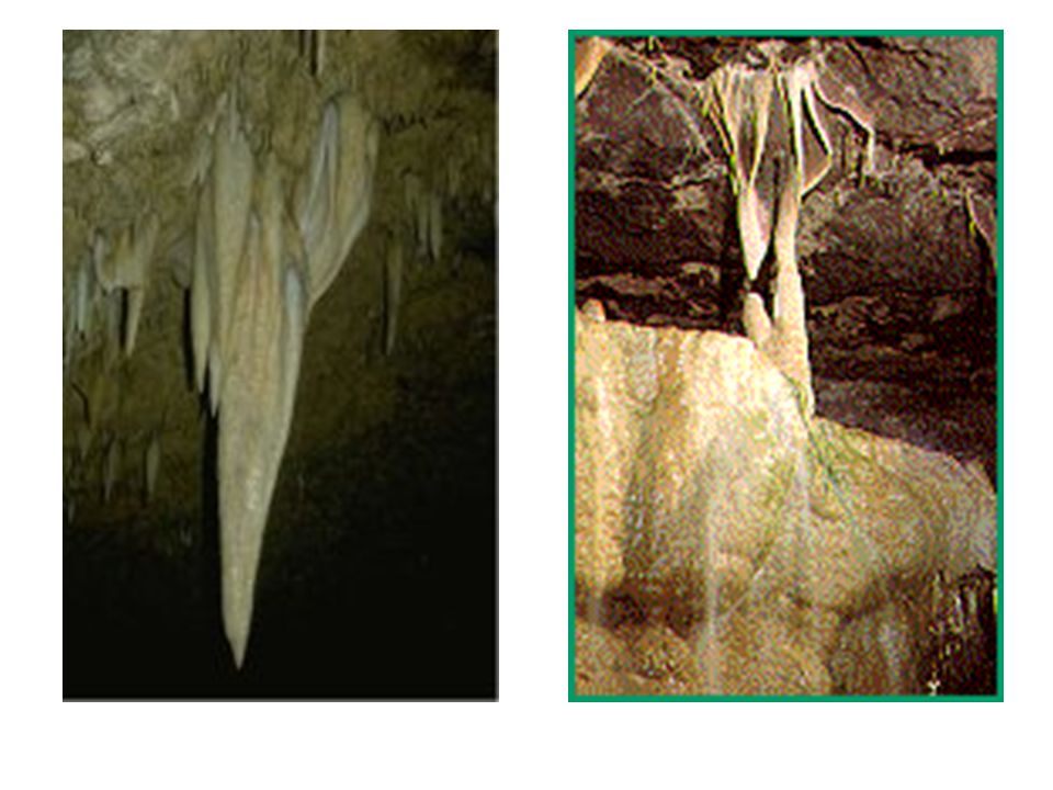
39
Re-appearance stream Stalactites and stalagmites

40
Dry valleys and gorges Theory 1 At the end of the last ice age all the cracks and joints in the limestone were filled with frozen water. This prevented water passing through the limestone. At this time the melting glaciers produced lots of water which passed over the landscape eroding deep river valleys . As the temperatures continued to rise the underground water melted, which meant surface water could pass through the cracks and joints in the limestone. This left the valleys as dry valleys. Theory 2 The roof on a series of underground caves collapses and leaves a gorge.

43
Summary of Peak district features
Complete the diagram from the power point ‘White Peak’ ‘Dark Peak’ Sheep grazing Crags (edges) Desolate rolling moorland Treeless rolling Plateau dissected By gorges Deep narrow gorges Limestone pavement Peat bog Peat bog Dry stone walls Hard millstone limestone Dairying Underground caves and caverns Limestone shale
 Desolate rolling. moorland. Treeless rolling. Plateau dissected. By gorges. Deep narrow. gorges. Limestone. pavement. Peat bog. Peat bog. Dry stone walls. Hard. millstone. limestone. Dairying. Underground caves. and caverns. Limestone. shale.")
46
Complete the grid Climate and veg Soils/ physical features Land use
High plateau Exposed rock and limestone pavement. Very little vegetation. Not a severe climate as it is not that high Thin soils. Flat topped Pot hole/ shake holes Disappearing streams Limestone pavement Recreation (walking, pot holing, mountain biking) Plateau edges Less exposed not very much veg because of the thin soils Steep cliffs on the edges of the plateau called scars with large scree slopes. Thin soils Climbing and abseiling, hang gliding). Water storage in the Dark Peak Quarrying Lower slopes valley floor Warmer and less harsh climate. Deciduous woodland, Oak and Beech but has mainly been cut down now. Rivers cut through the limestone plateaus where the rock is impermeable The soil either side of the rivers is rich and fertile. Streams reappear where impermeable rock begins Farming (sheep in the Dark Peak and dairying in the Light Peak). Water sports on the rivers Settlement and communication links. Sight seeing in towns e.g. Castleton Complete the grid
 Plateau edges. Less exposed not very much veg because of the thin soils. Steep cliffs on the edges of the plateau called scars with large scree slopes. Thin soils. Climbing and abseiling, hang gliding). Water storage in the Dark Peak. Quarrying. Lower slopes valley floor. Warmer and less harsh climate. Deciduous woodland, Oak and Beech but has mainly been cut down now. Rivers cut through the limestone plateaus where the rock is impermeable. The soil either side of the rivers is rich and fertile. Streams reappear where impermeable rock begins. Farming (sheep in the Dark Peak and dairying in the Light Peak). Water sports on the rivers. Settlement and communication links. Sight seeing in towns e.g. Castleton. Complete. the grid.")
47
Peak district-opportunities and conflicts

48
White Peak

49
Dark Peak

50
Mining - Tunstead Quarry
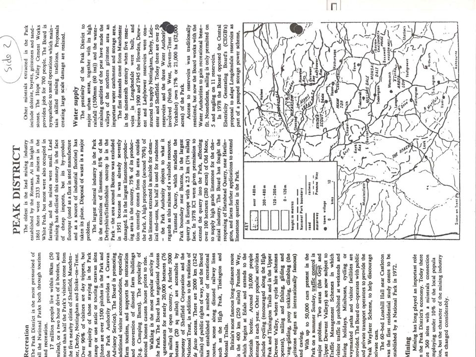
Largest quarry in Europe, straddles the park boundary Limestone is the main mineral extraction Extensions to the quarry have been resisted by the park authorities Hope Valley cement works provides 700 jobs Mining employs about 10% of the population of the peak district

51
Farming Sheep rearing on the hills of the Dark Peak
Dairying in the valleys of the White Peak (sheep on the hills) Moorlands are managed by burning the heather to maintain Grouse numbers for shooting
 Moorlands are managed by burning the heather to maintain. Grouse numbers for shooting.")
52
Water storage Water storage only in the impermeable rock of the Dark peak Good water retaining quality of the Peat High rainfall Close to major urban areas e.g. Manchester, Sheffield, Leeds E.G. Derwent reservoir and ladybower reservoir

53
Recreation and tourism
1/3 of the park is moorland. They provide some of the finest grouse shooting in the country The moors have to close for a few days a year during the shooting season Moorlands are managed by burning the heather to maintain Grouse numbers for shooting

54
Recreation and sightseeing
Walking most popular activity Old railway lines used e.g. High peak and Tissington and Monsul trails Cycling along the Tissington and High peak trails Pennine way (Britains longest distance walk) starts in the Peak district Pony treking Hang gliding Climbing on the grit stone edges Sightseeing in towns like Castleton Tourist caves – e.g. Blue John Mine
 starts in the Peak district. Pony treking. Hang gliding. Climbing on the grit stone edges. Sightseeing in towns like Castleton. Tourist caves – e.g. Blue John Mine.")
55
Woodland Coniferous forest owned by forestry commission is in and
around the reservoirs e.g. Snake valley, Goyt valley. Broadleaf woodland mainly on private land

56
Archaeology 3500 sites dating from 1500 AD
Stone age chambered tombs e.g. Taddington Castles e.g. Peveril castle Early industrial remains of textile Mills

57
Settlement and communication
Settlement built on flat land - Castleton Roads and railways built through lowlands and valleys e.g. A57 Small towns built up around bridging points Villages and isolated farms spread throughout the landscape

58
Conservation Northern limit of Southern species and
Southern limit of Northern species Many areas are SSSI’s e.g. Bleaklow and Kinder Scout Over 800 listed buildings Conservation of footpaths and dry stone walls important Underground features

59
Development opportunities
1. Complete the Diagram from the Resource sheet and slides Development opportunity Example Mining Farming Recreation/ sightseeing Water storage Settlement and communication Archaeology Conservation

60
Quarrying and farmers Crops (grass) does not grow as well as it is covered in dust Animals scared by blasting Animals scared by noise of trucks Quarrying and tourists Noise pollution effecting quiet scenery (blasting and trucks) Air pollution from dust Air pollution from trucks Trucks block roads and cause traffic tail backs Causes an ugly scar on the landscape
 Air pollution from dust. Air pollution from trucks. Trucks block roads and cause traffic tail backs. Causes an ugly scar on the landscape.")
61
Tourists and conservationists - footpaths
10,000s of walkers each year erode the footpaths and cause scarring Major erosion on Bleaklow and Kinder Scout Paths are closed in order to be reseeded Pennine Way is attempted by about 10,000 walkers each year Tourists and conservationists – traffic (Goyt Valley) Heavy traffic pressure especially at weekends Soil erosion, litter, damage to vegetation, damage to fences Solution – park and ride scheme at W/Es Car parks provided at either end. Only cyclists, pony trekkers, walkers allowed Picnic sites provided at main car parks and only one in valley itself
 Heavy traffic pressure especially at weekends. Soil erosion, litter, damage to vegetation, damage to fences. Solution – park and ride scheme at W/Es. Car parks provided at either end. Only cyclists, pony trekkers, walkers allowed. Picnic sites provided at main car parks and only one in valley itself.")
62
Tourists and farmers Leaving gates open and letting animals escape Leaving litter that animals eat Climbing over walls and fences and breaking them Taking short cuts through fields Letting dogs off leads that chase the sheep parking at field entrances Accidental fires Conservationists and farmers over grazing on heather moorlands causing soil erosion

63
Water storage and tourists
Over 50 reservoirs built in the area Access traditionally limited Now 11 reservoirs open for fishing and 5 available for sailing and canoeing e.g. Carsington, Rudyard and Errwood reservoirs Planning permission for sailing on Ladybower reservoir was turned down because of concerns over the rare ducks nesting there Zoning of the reservoir has helped overcome incompatible users

64
Land use conflicts The Peak district is the busiest of all the national parks. There are many potential conflicts in the area. Usually these are overcome by negotiated agreement on access between all the land users. From reading the information and watching the slides write down the main conflicts under the following headings. From reading the resource sheet and watching the power point write down the main conflicts under the following headings : The people involved The conflict with examples Quarrying and Farmers Quarrying and tourists Tourists and conservationists (footpaths) Tourists and Farmers Water storage and tourists Tourists and conservationists (traffic)
 Tourists and Farmers. Water storage and tourists. Tourists and conservationists (traffic)")
Similar presentations