Download presentation
Presentation is loading. Please wait.

2
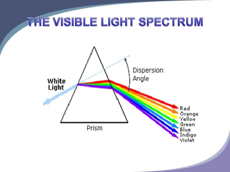
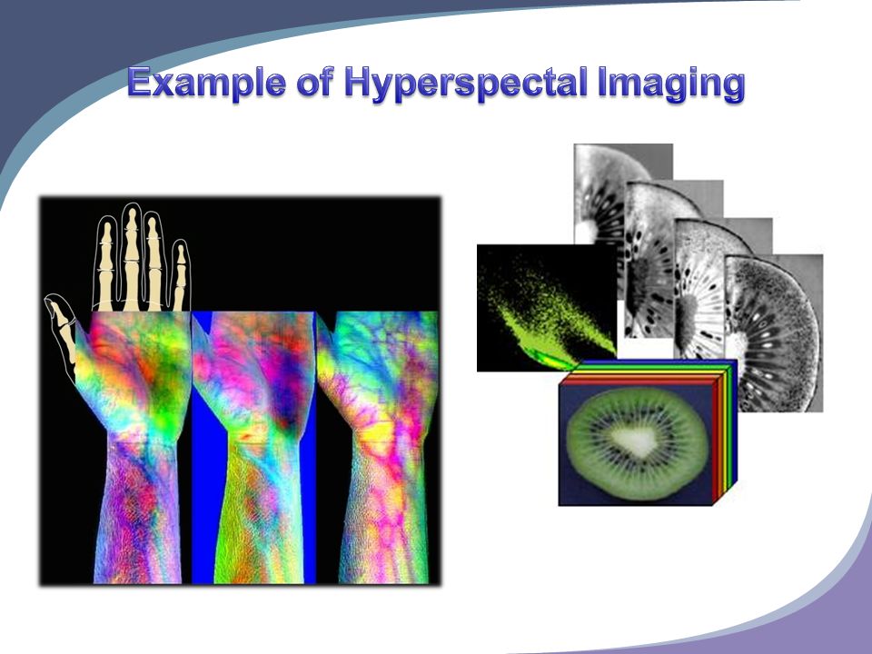
Collection of high resolution spectral detail over a large spatial and broad wavelength region from within each pixels instantaneous field of view A standard RGB image has three bands corresponding to red, green and blue. In contrast, a hyperspectral image records reflectance values at many different bands, typically > 200 bands. Many of these extra bands are in the ultraviolet and infrared ranges, outside the visible spectrum.

7
Military Hyperspectal imaging applications Civilian hyperspectral imager of the main application areas

8
Identification of camouflage: According to different spectral characteristics, the using hyperspectal imaging can find camouflaged target objects.

9
Weapons production survey Hyperspectral Imager can detect not only the spectral characteristics of the target but also can be used to analyze the material composition.By analyzing factory smoke, the material composition could be directly identified of the material which could help to determine the production of weapons Application of Naval Operations Analyzing imaging data like the transparency of the sea, the ocean depths, underwater hazards, currents, oil spills, seabed type, Oceanic and Atmospheric visibility, tides, bioluminescence, beach characteristics, the total amount of atmospheric water vapor could be very useful for naval operations.

10
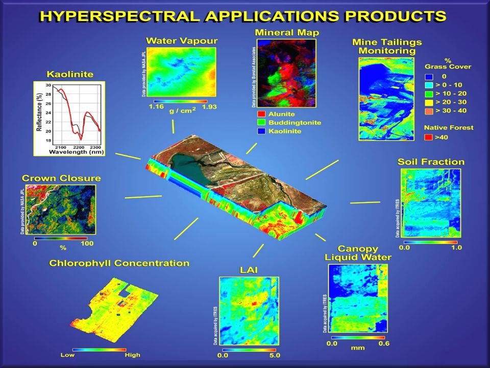
Survey of land resources, including mineral exploration, forest grassland surveys, land-use categories, urban planning, land desertification and soil degradation,etc. Remote sensing in forestry, including forest resources, deforestation, reforestation and forest protection. Environmental monitoring, including assessment of the ecological environment and ecological change investigation. Marine applications, including marine resources survey, water quality changes in water color, chlorophyll and plankton content analysis, coastal zone and marine ecosystems change and marine pollution monitoring

11
Agricultural applications, including assessment of crop growth and yield, crop type of investigation and monitoring of pests and diseases. Monitoring of natural disasters, including floods, droughts, hail, forest fires and earthquakes, such as multi-hazard monitoring and disaster assessment. The universe, atmosphere, space environment and a wide range of fields such as astronomy applications.

14
GVS (Green Vision Systems) is bringing to the market the next level of tracking biochemical contamination sources, such as city air pollution, by providing a comprehensive product suite that replaces processes of days, weeks and even months with that of hours or less. The suite is based on the company's patented and field- proven HSI (Hyper-Spectral Imaging) technology. GVS has already initiated mega projects with customers and partners, including in Europe, in Singapore and in the USA.
 technology. GVS has already initiated mega projects with customers and partners, including in Europe, in Singapore and in the USA..")
15
GVS was founded in 1996. Today, after more than 10 years in HSI technology (over 200 engineering man years) and 11 international patents, GVS is an ISO-9001 approved company and its products have been approved under the UL (Underwriters Laboratories) and CE (Conformance European) standards.
 and 11 international patents, GVS is an ISO-9001 approved company and its products have been approved under the UL (Underwriters Laboratories) and CE (Conformance European) standards..")
16
The suite is composed of several modular systems, enabling GVS to provide a solution that is tailor-made to the needs of each organization. It includesproducts for real-time data collection in the field (HyperEye™-ID platforms),integrated network communication (INSIP- 20™ software) and analysis in a central location (FIPA®- 20/40 systems). Below is a more detailed presentation of three of the suite's main HSI-based products:
,integrated network communication (INSIP- 20™ software) and analysis in a central location (FIPA®- 20/40 systems). Below is a more detailed presentation of three of the suite s main HSI-based products:.")
17
HyperEye™-ID (Immediate Detection) is an online station for air pollution monitoring, enabling 24/7 monitoring and tracking of air pollution in urban environments, including threats ranging from industrial/automotive contamination to Anthrax clouds due to terrorist activities. HyperEye™-ID

18
HyperEye™-RS (Remote Sensing) is a real-time remote sensing system, which should be placed on buildings or other high locations, for objects/surface spectral classification and tracking. HyperEye™- RS FIPA®-20/40 (Fluorescence Imaging Particle Analyzer) is semi-online system for laboratory P.M. (Particulate Matter1) investigation HSI microscopy. It captures, analyzes and generates information on the chemical, morphological and polymorphism (crystallization) characteristics of scanned particles (according to the C.M.B. standard). FIPA® -20/40
 is semi-online system for laboratory P.M. (Particulate Matter1) investigation HSI microscopy. It captures, analyzes and generates information on the chemical, morphological and polymorphism (crystallization) characteristics of scanned particles (according to the C.M.B. standard). FIPA® -20/40.")
19
ICNG Holding B.V. Scandinaviëweg 14 9723 AV GroningenThe NetherlandsTel:+31628807221 E mail: info@icng-holding.com Web: www.icng-holding.com

Similar presentations


 Open Joint-Stock.>")


 Turquoise = phytoplankton bloom.>")


 which was also the beginning.>")

