Download presentation
Presentation is loading. Please wait.

1
Nares Strait Aug.-3, 2009 Level-1B Band-1 @ 645nm

2
Infrared measurements of sea surface temperature (SST) Nares Strait motivation Vertical and temporal temperature changes Sensor calibration Cloud detection Atmospheric correction Validation References: 1. Robinson, I.S., 2004: Measuring the Oceans from Space, chapt.-7 2. Gumley, L., 2006: Modis Ocean Products, http://www.ssec.wisc.edu/library/coursefiles/SouthAfrica/Gumley_MODIS_Ocean.ppthttp://www.ssec.wisc.edu/library/coursefiles/SouthAfrica/Gumley_MODIS_Ocean.ppt 3. Vincent et al., 2008: Arctic waters and marginal ice zones, a composite Arctic sea surface temperature algorithm, J. Geophys. Res., 113, C04021, doi:10.1029/2007JC004353. 4. Luo, et al., 2008: Developing clear sky, cloud, and cloud shadow mask for producing clear-sky composites at 250-meter spatial resolution, Rem. Sens. Env., 112, 4167-4185. 5. Minnett, P.J., 2001: The marine-atmosphere emitted radiance interferometer, a high accuracy, seagoing infrared spectrometer, J, Atmos. Ocean. Tech., 18, 994-1013. Andreas Muenchow, University of Delaware, May-11, 2010

3
My first MODIS SST image (made 4 days ago): Pretty, but wrong on so many levels … Nares Strait Aug.-3, 2009 What is SST?
: Pretty, but wrong on so many levels … Nares Strait Aug.-3, 2009 What is SST")
4
Geophysical Parameter Name Description nLw_412Normalized water-leaving radiance at 412 nm nLw 443Normalized water-leaving radiance at 443 nm nLw_488Normalized water-leaving radiance at 488 nm nLw_531Normalized water-leaving radiance at 531 nm nLw_551Normalized water-leaving radiance at 551 nm nLw_667Normalized water-leaving radiance at 667 nm Tau_869Aerosol optical thickness at 869 nm Eps_78Epsilon of aerosol correction at 748 and 869 nm Chlor_aOC3 Chlorophyll a concentration K490Diffuse attenuation coefficient at 490nm Angstrom_531Angstrom coefficient, 531-869 nm SSTSea Surface Temperature: 11 micron SST4Sea Surface Temperature: 4 micron (night only) MODIS Ocean Standard Products (Level-2) [from Gumley, 2006]
![Geophysical Parameter Name Description nLw_412Normalized water-leaving radiance at 412 nm nLw 443Normalized water-leaving radiance at 443 nm nLw_488Normalized water-leaving radiance at 488 nm nLw_531Normalized water-leaving radiance at 531 nm nLw_551Normalized water-leaving radiance at 551 nm nLw_667Normalized water-leaving radiance at 667 nm Tau_869Aerosol optical thickness at 869 nm Eps_78Epsilon of aerosol correction at 748 and 869 nm Chlor_aOC3 Chlorophyll a concentration K490Diffuse attenuation coefficient at 490nm Angstrom_531Angstrom coefficient, nm SSTSea Surface Temperature: 11 micron SST4Sea Surface Temperature: 4 micron (night only) MODIS Ocean Standard Products (Level-2) [from Gumley, 2006]](http://images.slideplayer.com/13/3922201/slides/slide_4.jpg "Geophysical Parameter Name Description nLw_412Normalized water-leaving radiance at 412 nm nLw 443Normalized water-leaving radiance at 443 nm nLw_488Normalized water-leaving radiance at 488 nm nLw_531Normalized water-leaving radiance at 531 nm nLw_551Normalized water-leaving radiance at 551 nm nLw_667Normalized water-leaving radiance at 667 nm Tau_869Aerosol optical thickness at 869 nm Eps_78Epsilon of aerosol correction at 748 and 869 nm Chlor_aOC3 Chlorophyll a concentration K490Diffuse attenuation coefficient at 490nm Angstrom_531Angstrom coefficient, nm SSTSea Surface Temperature: 11 micron SST4Sea Surface Temperature: 4 micron (night only) MODIS Ocean Standard Products (Level-2) [from Gumley, 2006]")
5
sst4sst sst4 usable only at night (solar contributions) sst usable day and night (negligible solar contributions) 2 bands used to estimate sst and sst4 Planck’s Law: [from Robinson, 2004]
![sst4sst sst4 usable only at night (solar contributions) sst usable day and night (negligible solar contributions) 2 bands used to estimate sst and sst4 Planck’s Law: [from Robinson, 2004]](http://images.slideplayer.com/13/3922201/slides/slide_5.jpg "sst4sst sst4 usable only at night (solar contributions) sst usable day and night (negligible solar contributions) 2 bands used to estimate sst and sst4 Planck’s Law: [from Robinson, 2004]")
6
sst4 sst [from Robinson, 2004]
![sst4 sst [from Robinson, 2004]](http://images.slideplayer.com/13/3922201/slides/slide_6.jpg "sst4 sst [from Robinson, 2004]")
10
[from Minnett et al., 2001]
![[from Minnett et al., 2001]](http://images.slideplayer.com/13/3922201/slides/slide_10.jpg "[from Minnett et al., 2001]")
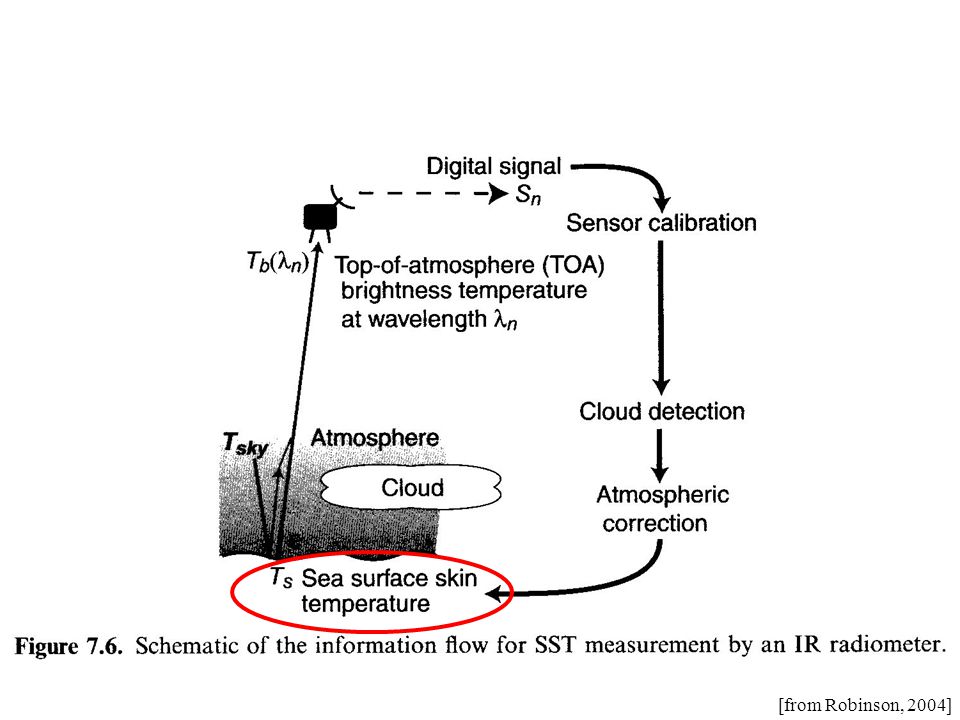
11
[from Robinson, 2004]
![[from Robinson, 2004]](http://images.slideplayer.com/13/3922201/slides/slide_11.jpg "[from Robinson, 2004]")
12
NightDay [from Robinson, 2004]
![NightDay [from Robinson, 2004]](http://images.slideplayer.com/13/3922201/slides/slide_12.jpg "NightDay [from Robinson, 2004]")
15
Sensor Calibration Band-integrated radiance as a function of temperature (Planck’s Law) at detector: L(T b ) = ∫ C 1 ( ) / [ 5 exp(C 2 / T b )-1] d where T b blackbody temperature ( ) detector response function (determined pre-launch) C 1, C 2 constants L = gain*S + offsetor T b = A + B ln(L) Calibration finds gain and offset to relate the digital output signal S to radiance at detector L: Need 2 known points to find gain and offset for each detector
![Sensor Calibration Band-integrated radiance as a function of temperature (Planck’s Law) at detector: L(T b ) = ∫ C 1 ( ) / [ 5 exp(C 2 / T b )-1] d where T b blackbody temperature ( ) detector response function (determined pre-launch) C 1, C 2 constants L = gain*S + offsetor T b = A + B ln(L) Calibration finds gain and offset to relate the digital output signal S to radiance at detector L: Need 2 known points to find gain and offset for each detector](http://images.slideplayer.com/13/3922201/slides/slide_15.jpg "Sensor Calibration Band-integrated radiance as a function of temperature (Planck’s Law) at detector: L(T b ) = ∫ C 1 ( ) / [ 5 exp(C 2 / T b )-1] d where T b blackbody temperature ( ) detector response function (determined pre-launch) C 1, C 2 constants L = gain*S + offsetor T b = A + B ln(L) Calibration finds gain and offset to relate the digital output signal S to radiance at detector L: Need 2 known points to find gain and offset for each detector")
16
Striping due to imperfect inter-detector calibrations SST MODIS has 10 detectors scanned by 2 mirror-sides --> 20 calibrations [from Gumley, 2006]
![Striping due to imperfect inter-detector calibrations SST MODIS has 10 detectors scanned by 2 mirror-sides --> 20 calibrations [from Gumley, 2006]](http://images.slideplayer.com/13/3922201/slides/slide_16.jpg "Striping due to imperfect inter-detector calibrations SST MODIS has 10 detectors scanned by 2 mirror-sides --> 20 calibrations [from Gumley, 2006]")
17
Chlor_a [from Gumley, 2006]
![Chlor_a [from Gumley, 2006]](http://images.slideplayer.com/13/3922201/slides/slide_17.jpg "Chlor_a [from Gumley, 2006]")
18
MODIS Chlorophyll Algorithm Semi-analytical algorithm (1) Chl_a = 10**(0.283 - 2.753*R + 1.457*R 2 + 0.659*R 3 - 1.403*R 4 ) where: R = log10((Rrs443 > Rrs488) / Rrs551) Rrs = nLw / F0; remote sensing reflectance F0 = extraterrestrial solar irradiance nLw = water leaving radiance at 443, 488, 551 (1) Performance of the MODIS Semi-analytical Ocean Color Algorithm for Chlorophyll-a Carder, K.L.; Chen, F.R.; Cannizzaro, J.P.; Campbell, J.W.; Mitchell, B.G. Advances in Space Research. Vol. 33, no. 7, pp. 1152-1159. 2004 [from Gumley, 2006]

19
[from Robinson, 2004]
![[from Robinson, 2004]](http://images.slideplayer.com/13/3922201/slides/slide_19.jpg "[from Robinson, 2004]")
20
Canadian Center for Remote Sensing Cloud Detection Standard NASA Cloud Detection [from Luo et al., 2008]
![Canadian Center for Remote Sensing Cloud Detection Standard NASA Cloud Detection [from Luo et al., 2008]](http://images.slideplayer.com/13/3922201/slides/slide_20.jpg "Canadian Center for Remote Sensing Cloud Detection Standard NASA Cloud Detection [from Luo et al., 2008]")
21
This really is another full lecture [from Robinson, 2004]
![This really is another full lecture [from Robinson, 2004]](http://images.slideplayer.com/13/3922201/slides/slide_21.jpg "This really is another full lecture [from Robinson, 2004]")
23
2008 [from Luo et al., 2008]
![2008 [from Luo et al., 2008]](http://images.slideplayer.com/13/3922201/slides/slide_23.jpg "2008 [from Luo et al., 2008]")
24
Modis Bands B i with i=1,2,3,6 [from Luo et al., 2008]
![Modis Bands B i with i=1,2,3,6 [from Luo et al., 2008]](http://images.slideplayer.com/13/3922201/slides/slide_24.jpg "Modis Bands B i with i=1,2,3,6 [from Luo et al., 2008]")
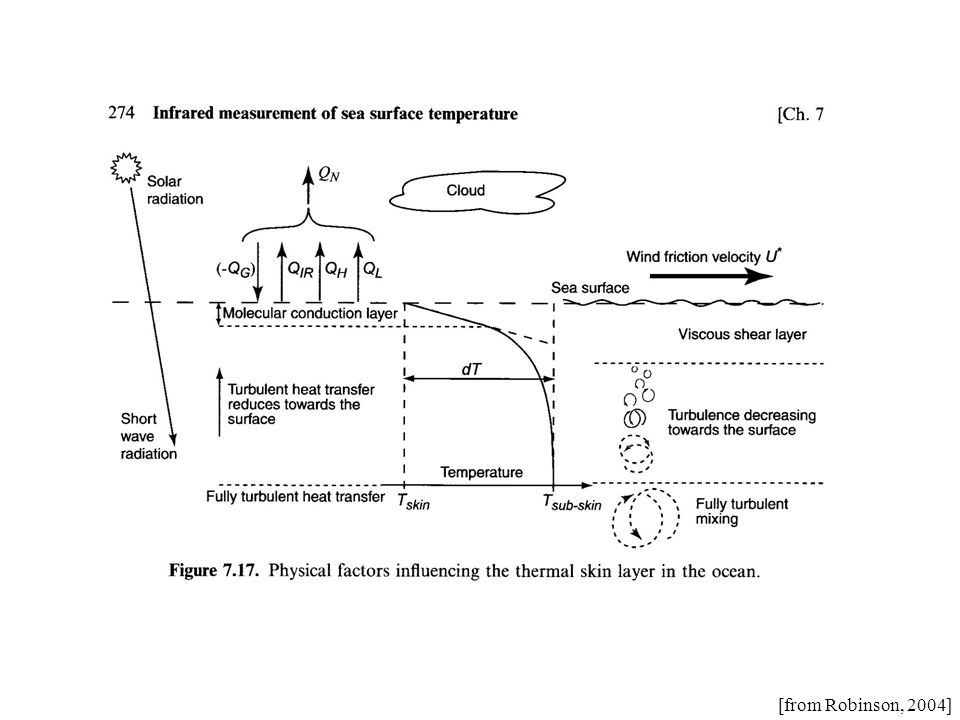
27
[from Robinson, 2004]
![[from Robinson, 2004]](http://images.slideplayer.com/13/3922201/slides/slide_27.jpg "[from Robinson, 2004]")
28
SST = a + b*T 4 + c*(T 4 -T 5 ) + d* (T 4 -T 5 )*(sec -1) T bi brightness temperature channel “i”, e.g, T 4 (Band-31 in Modis) T bj brightness temperature channel “j”, e.g, T 5 (Band-32 in Modis) Atmosphere-A:Atmosphere-B [from Robinson, 2004]
![SST = a + b*T 4 + c*(T 4 -T 5 ) + d* (T 4 -T 5 )*(sec -1) T bi brightness temperature channel i , e.g, T 4 (Band-31 in Modis) T bj brightness temperature channel j , e.g, T 5 (Band-32 in Modis) Atmosphere-A:Atmosphere-B [from Robinson, 2004]](http://images.slideplayer.com/13/3922201/slides/slide_28.jpg "SST = a + b*T 4 + c*(T 4 -T 5 ) + d* (T 4 -T 5 )*(sec -1) T bi brightness temperature channel i , e.g, T 4 (Band-31 in Modis) T bj brightness temperature channel j , e.g, T 5 (Band-32 in Modis) Atmosphere-A:Atmosphere-B [from Robinson, 2004]")
29
SST = a + b*T 4 + c*(T 4 -T 5 ) + d* (T 4 -T 5 )*(sec -1) a=-263.006 b=0.963563 c=2.579211 d=0.242598 sensor zenith Daytime Coefficients for NOAA-12 AVHRR SST algorithm(McClain et al., 1985) SST SST4 [from Robinson, 2004]
![SST = a + b*T 4 + c*(T 4 -T 5 ) + d* (T 4 -T 5 )*(sec -1) a= b= c= d= sensor zenith Daytime Coefficients for NOAA-12 AVHRR SST algorithm(McClain et al., 1985) SST SST4 [from Robinson, 2004]](http://images.slideplayer.com/13/3922201/slides/slide_29.jpg "SST = a + b*T 4 + c*(T 4 -T 5 ) + d* (T 4 -T 5 )*(sec -1) a= b= c= d= sensor zenith Daytime Coefficients for NOAA-12 AVHRR SST algorithm(McClain et al., 1985) SST SST4 [from Robinson, 2004]")
30
MODIS Longwave Infrared Sea Surface Temperature ---> SST dBT <= 0.5 sst = a00 + a01*BT11 + a02*dBT*bsst + a03*dBT*(sec() - 1.0) dBT >= 0.9 sst = a10 + a11*BT11 + a12*dBT*bsst + a13*dBT*(sec() - 1.0) 0.5 < dBt < 0.9 sstlo = a00 + a01*BT11 + a02*dBT*bsst + a03*dBT*(sec() - 1.0) ssthi = a10 + a11*BT11 + a12*dBT*bsst + a13*dBT*(sec() - 1.0) sst = sstlo + (dBT - 0.5)/(0.9 - 0.5)*(ssthi - sstlo) where: dBT = BT11 - BT12 BT11 = brightness temperature at 11 um, in deg-C BT12 = brightness temperature at 12 um, in deg-C bsst = Either sst4 (if valid) or sstref (from Reynolds OISST) sec() = 1/(cosine of sensor zenith angle) a00, a01, a02, a03, a10, a11, a12, a13 derived from match-ups [from Gumley, 2006]
![MODIS Longwave Infrared Sea Surface Temperature ---> SST dBT <= 0.5 sst = a00 + a01*BT11 + a02*dBT*bsst + a03*dBT*(sec() - 1.0) dBT >= 0.9 sst = a10 + a11*BT11 + a12*dBT*bsst + a13*dBT*(sec() - 1.0) 0.5 < dBt < 0.9 sstlo = a00 + a01*BT11 + a02*dBT*bsst + a03*dBT*(sec() - 1.0) ssthi = a10 + a11*BT11 + a12*dBT*bsst + a13*dBT*(sec() - 1.0) sst = sstlo + (dBT - 0.5)/( )*(ssthi - sstlo) where: dBT = BT11 - BT12 BT11 = brightness temperature at 11 um, in deg-C BT12 = brightness temperature at 12 um, in deg-C bsst = Either sst4 (if valid) or sstref (from Reynolds OISST) sec() = 1/(cosine of sensor zenith angle) a00, a01, a02, a03, a10, a11, a12, a13 derived from match-ups [from Gumley, 2006]](http://images.slideplayer.com/13/3922201/slides/slide_30.jpg "MODIS Longwave Infrared Sea Surface Temperature ---> SST dBT <= 0.5 sst = a00 + a01*BT11 + a02*dBT*bsst + a03*dBT*(sec() - 1.0) dBT >= 0.9 sst = a10 + a11*BT11 + a12*dBT*bsst + a13*dBT*(sec() - 1.0) 0.5 < dBt < 0.9 sstlo = a00 + a01*BT11 + a02*dBT*bsst + a03*dBT*(sec() - 1.0) ssthi = a10 + a11*BT11 + a12*dBT*bsst + a13*dBT*(sec() - 1.0) sst = sstlo + (dBT - 0.5)/( )*(ssthi - sstlo) where: dBT = BT11 - BT12 BT11 = brightness temperature at 11 um, in deg-C BT12 = brightness temperature at 12 um, in deg-C bsst = Either sst4 (if valid) or sstref (from Reynolds OISST) sec() = 1/(cosine of sensor zenith angle) a00, a01, a02, a03, a10, a11, a12, a13 derived from match-ups [from Gumley, 2006]")
31
MODIS Shortwave Infrared Sea Surface Temperature --> SST4 sst4 = a0 + a1 * BT39 + a2 * dBT + a3 * ( sec() - 1.0 ) where: dBT = BT39 - BT40 BT39 = brightness temperature at 3.959 um, in deg-C BT40 = brightness temperature at 4.050 um, in deg-C sec() = 1/(cosine of sensor zenith angle) a0, a1, a2, and a3 are time dependent coefficients derived from match- ups between observed MODIS brightness temperature and field measurements of SST. Note: sst4 is not valid during daytime because of solar reflection. [from Gumley, 2006]

32
Measuring at-sea skin temperature for SST validation and algorithm development [from Minnett et al., 2001]
![Measuring at-sea skin temperature for SST validation and algorithm development [from Minnett et al., 2001]](http://images.slideplayer.com/13/3922201/slides/slide_32.jpg "Measuring at-sea skin temperature for SST validation and algorithm development [from Minnett et al., 2001]")
33
My first MODIS SST image (made 4 days ago): Pretty, but wrong on so many levels … Nares Strait Aug.-3, 2009 What is SST?
: Pretty, but wrong on so many levels … Nares Strait Aug.-3, 2009 What is SST")
34
Standard SST algorithm Arctic SST algorithm [from Vincent et al., 2008]
![Standard SST algorithm Arctic SST algorithm [from Vincent et al., 2008]](http://images.slideplayer.com/13/3922201/slides/slide_34.jpg "Standard SST algorithm Arctic SST algorithm [from Vincent et al., 2008]")
37
Is atmospheric correction always appropriate? SST = a + b*T 4 + c*(T 4 -T 5 ) + d* (T 4 -T 5 )*(sec -1) Is anything lost by applying atmospheric corrections?
 + d* (T 4 -T 5 )*(sec -1) Is anything lost by applying atmospheric corrections .")
38
Is atmospheric correction always appropriate? SST = a + b*T 4 + c*(T 4 -T 5 ) + d* (T 4 -T 5 )*(sec -1) Is anything lost by applying atmospheric corrections? Image noise may be enhanced Includes noise from 2channels Thermal gradients are modified
 + d* (T 4 -T 5 )*(sec -1) Is anything lost by applying atmospheric corrections. Image noise may be enhanced Includes noise from 2channels Thermal gradients are modified.")
39
Is atmospheric correction always appropriate? SST = a + b*T 4 + c*(T 4 -T 5 ) + d* (T 4 -T 5 )*(sec -1) Is anything lost by applying atmospheric corrections? Image noise may be enhanced Includes noise from 2channels Thermal gradients are modified If spatial structures, patterns, fronts, eddies, plumes are studied Use brightness temperatures T i, not SST
 + d* (T 4 -T 5 )*(sec -1) Is anything lost by applying atmospheric corrections. Image noise may be enhanced Includes noise from 2channels Thermal gradients are modified If spatial structures, patterns, fronts, eddies, plumes are studied Use brightness temperatures T i, not SST.")
Similar presentations


 Kirsten de Beurs.>")

 basics NASA Ocean Biology Processing Group Goddard Space Flight Center,>")
, Sue Walsh, Vicki Halliwell, Liz.>")

>")


